Local events in Dennison
Nothing is posted for Dennison itself yet; here is what is on within 20 miles. All local events in Dennison
Know a calendar we should watch? Send the link
Checked October 20; the events page is refreshed daily.
How Dennison began
Dennison was laid out in 1865 by the Dennison Land Company and incorporated as a village in 1873, named for Ohio Governor William Dennison. It grew almost overnight into a railroad town after the Pittsburgh, Cincinnati & St. Louis Railway built the country's largest locomotive shops and yards there in 1864, employing about 3,000 workers at peak and spanning parts of Mill and Union townships. During the Second World War its depot restaurant ran as the Red Cross canteen "Dreamsville," serving troop trains around the clock from 1942 to 1946. Rail traffic wound down through the late 20th century, and the depot survives today as the Dennison Railroad Depot Museum.
Platted 1865, incorporated 1873, by the Dennison Land Company.
Where the name comes from
Dennison was named for William Dennison Jr., who served as Ohio's governor from 1860 to 1862 (and later as U.S. Postmaster General); the town grew around the Pittsburgh, Cincinnati & St. Louis Railway's shops and was laid out by the Dennison Land Company in 1865.
Before the town
No Native American village, trail, or treaty site specific to the ground that became Dennison (platted new in 1865, well after the Treaty of Greenville opened the county) is documented in the sources consulted. Dennison spans parts of Mill and Union townships in the Tuscarawas River valley, ground that was Delaware (Lenape) country through the 18th century.
Timeline
- — The Pittsburgh, Cincinnati & St. Louis Railway builds what becomes the country's largest railroad shops and yards at the site, chosen because it sits about 100 miles from both Pittsburgh and Columbus, a convenient point for locomotive water stops.
- — The Dennison Land Company lays out the town of Dennison, named for former Ohio Governor William Dennison.
- — Dennison incorporates as a village.
- — The village records its historical population peak of 5,524.
- — A nationwide railroad shopmen's strike hits Dennison hard, and the village's population declines afterward.
- — A Red Cross servicemen's canteen opens March 19 in a gas station at Center and Fifth streets to serve troop trains passing through Dennison.
- — The canteen, relocated to the depot restaurant and nicknamed "Dreamsville," closes April 8 after nearly four years of round-the-clock service to troop trains.
- — Passenger rail service through Dennison ends.
- — The last freight stop at Dennison's yards takes place, closing out the town's working railroad era.
- — The Pennsylvania Railroad Depot and Baggage Room is designated a National Historic Landmark on June 17.
Stories
Dreamsville: the depot canteen
During the Second World War, hundreds of troop trains a month passed through Dennison's yards, and on March 19, 1942, local volunteers opened a Red Cross canteen in a gas station at Center and Fifth streets to meet the soldiers with food and coffee during their brief stops. Demand quickly outgrew the gas station, and the canteen moved into the depot's own restaurant, where it earned the nickname "Dreamsville" from the soldiers who passed through it. Volunteers kept it running around the clock for the length of the war and beyond, finally closing on April 8, 1946 — nearly four years after it opened — having served an untold number of servicemen a hot meal and a friendly face on their way to and from the front.
A rail town from nothing
Before 1864 there was no town here at all. The Pittsburgh, Cincinnati & St. Louis Railway picked the spot deliberately: it sat almost exactly 100 miles from both Pittsburgh and Columbus, a natural place to water locomotives and swap crews, so the railroad built what became the country's largest set of railroad shops and yards on the site that year. The Dennison Land Company platted the town around the yards in 1865 and named it for Ohio's wartime governor, William Dennison; the village incorporated in 1873. At its peak the shops employed about 3,000 workers and the village held more than 5,500 people in 1920, before a 1922 nationwide shopmen's strike marked the start of a long decline that mirrored the American railroad industry's own contraction — passenger service ended in 1968 and the last freight stop came in 1982.
Photographs
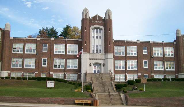
Photo: Wikimedia Commons user Bwsmith84, CC BY 3.0 · Wikimedia Commons
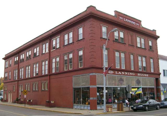
Photo: Wikimedia Commons user Bwsmith84, CC BY 3.0 · Wikimedia Commons
Local history sources: en.wikipedia.org · en.wikipedia.org · commons.wikimedia.org · commons.wikimedia.org
Historic places
4 places in Dennison on the National Register of Historic Places, 1 of them National Historic Landmark. Press a pin or a name for its whole record.
-
Pennsylvania Railroad Depot And Baggage Room LandmarkBuilding · Dennison · listed 1976
- Address
- 400 Center St.
- Where
- Dennison, Tuscarawas County · ZIP 44621
- What it is
- Building
- Listed on the National Register
- 1976
- National Historic Landmark
- Yes
- NRIS reference number
- 76001536
- Coordinates
- 40.39207, -81.33210
National Register file (NPS) ↗ Search Wikipedia ↗ Street map and directions ↗ On the Cracked Buckeye map
-
Dennison High SchoolBuilding · Dennison · listed 2006
- Address
- 220 N. Third St.
- Where
- Dennison, Tuscarawas County · ZIP 44621
- What it is
- Building
- Listed on the National Register
- 2006
- NRIS reference number
- 05001573
- Coordinates
- 40.39450, -81.33335
National Register file (NPS) ↗ Search Wikipedia ↗ Street map and directions ↗ On the Cracked Buckeye map
-
Lanning, T., & Co. Department StoreBuilding · Dennison · listed 2000
- Address
- 226-228 Grant St.
- Where
- Dennison, Tuscarawas County · ZIP 44621
- What it is
- Building
- Listed on the National Register
- 2000
- NRIS reference number
- 00000420
- Coordinates
- 40.39297, -81.33411
National Register file (NPS) ↗ Search Wikipedia ↗ Street map and directions ↗ On the Cracked Buckeye map
-
Railway Chapel, TheBuilding · Dennison · listed 2009
- Address
- 301 Grant St.
- Where
- Dennison, Tuscarawas County · ZIP 44621
- What it is
- Building
- Listed on the National Register
- 2009
- NRIS reference number
- 09000212
- Coordinates
- 40.39612, -81.33377
National Register file (NPS) ↗ Search Wikipedia ↗ Street map and directions ↗ On the Cracked Buckeye map
Source: National Park Service, National Register of Historic Places point file. The listing year is shown where NPS's certification date agrees with the listing's reference number. Listing recognizes significance; it does not restrict a private owner.
Water
Tuscarawas River valley aquifer (local wells) The water here
- Twin City Water and Sewer District98% of residentsTuscarawas River valley aquifer (local wells)
- Aqua Ohio - Midvale2% of residentsGroundwater wells (3 wells)
Hospitals, fire stations and more
Inside Dennison's boundary: 1 hospital, 1 fire or EMS station, 1 public school, 1 private school, 1 poor-rated bridge, 1 library, 2 museums, 1 police station and 2 spill cases. Press a pin or a name for its whole record and its source.
Hospitals (1)
-
Twin City Medical CenterGeneral hospital · Dennison
- What it is
- General hospital
- Address
- 819 North First Street, Dennison, OH 44621
- County
- Tuscarawas County
- Beds
- 25
- Helipad
- Yes
- Ownership
- Non-profit
- Medicare overall rating
- not rated
- Emergency department (Medicare)
- Yes
- Phone
- (740) 922-2800
- Medicare ID
- 361302
Medicare Care Compare ↗ Where HIFLD got this record ↗ HIFLD hospitals (source) ↗ Street map and directions ↗
Source: HIFLD hospitals inventory via FEMA (closed hospitals it still lists left out, hospitals opened since added), with Medicare Care Compare ratings matched by name and address.
Fire and EMS stations (1)
-
Dennison Fire DepartmentDennison
- Address
- 302 Grant Street, Dennison, OH 44621
- Coordinates
- 40.39280, -81.33393
USGS National Map structures (source) ↗ Street map and directions ↗
Source: USGS National Map structures (most Ohio records last updated 2019 to 2022), checked against the Columbus and Cleveland station lists. The department that answers a call is set by jurisdiction and mutual aid, not by distance.
Public schools (1)
-
Claymont Intermediate School2.5 of 5 stars · Dennison
- Address
- 220 N 3rd St, Dennison, OH 44621
- School district
- Claymont City School District
- Kind (NCES)
- Regular School
- Students, 2023-24
- 347
- Teachers (full-time equivalent)
- 18.75
- Report card, 2025-26
- 2.5 of 5 stars
- Performance index
- 68.7%
- Ohio building IRN
- 027805
- NCES school ID
- 390437700407
NCES school record ↗ Ohio School Report Card ↗ Street map and directions ↗
Source: NCES EDGE public school locations 2024-25 and Common Core of Data 2023-24 (type, students, teachers); Ohio School Report Cards 2025-26 (Department of Education and Workforce), matched by name within the district.
Private schools (1)
-
Immaculate ConceptionPrivate, Catholic · Dennison
- Address
- 100 Sherman St, Dennison, OH 44621
- Kind
- Catholic
- Students, 2023-24
- 108
- Teachers (full-time equivalent)
- 9.9
- Students per teacher
- 10.9091
- Phone
- (740) 922-3539
- NCES private school ID
- A1903443
Source: NCES Private School Survey 2023-24.
Bridges rated poor (1)
-
1st St & Denn Corp over Little Stillwater CreekPoor · built 1941
- Condition
- Poor: a deck, superstructure, substructure or culvert rated 4 or below on the 0 to 9 scale
- What it is
- Bridge
- Built
- 1941
- Length
- 31 ft
- Owner
- City
- Vehicles a day
- 1,957
- Coordinates
- 40.39050, -81.33577
National Bridge Inventory (source) ↗ Street map and directions ↗
Source: FHWA National Bridge Inventory 2025. "Poor" means one major part rated 4 or below on the 0 to 9 scale; it calls for repair, not closing, unless the state posts or closes the bridge.
Public libraries (1)
-
Dennison Branch LibraryBranch · Dennison
- Address
- 15 N. 4Th Street, Dennison, OH 44621
- What it is
- Branch
- Library system
- Claymont School District Public Library
- Open
- 936 hours a year, 52 weeks
- Building
- 3,700 sq ft
- System's visits, FY2024
- 9,724
- System's loans, FY2024
- 106,717
- People the system serves
- 11,834
- Phone
- (740) 922-5851
IMLS Public Libraries Survey (source) ↗ Street map and directions ↗
Source: IMLS Public Libraries Survey FY2024 (outlets and their systems). Any Ohio resident can get a free card at any Ohio public library.
Museums, historical societies, gardens and zoos (2)
-
Dennison Railroad Depot MuseumMuseum · Dennison
- What it is
- Museum
- City
- Dennison
- Coordinates
- 40.39211, -81.33150
Search Wikipedia ↗ IMLS Museum Data Files (source) ↗ Street map and directions ↗
The museum list is IMLS's 2018 file; a museum may have closed or moved since.
-
Historic Center Street AssociationHistorical society · Dennison
- What it is
- Historical society
- City
- Dennison
- Coordinates
- 40.41126, -81.31985
Search Wikipedia ↗ IMLS Museum Data Files (source) ↗ Street map and directions ↗
The museum list is IMLS's 2018 file; a museum may have closed or moved since.
Source: IMLS Museum Data Files, 2018.
Police stations (1)
-
Dennison Police DepartmentDennison
- Address
- 302 Grant Street, Dennison, OH 44621
- Coordinates
- 40.39291, -81.33386
USGS National Map structures (source) ↗ Street map and directions ↗
Source: USGS National Map structures, police stations, corrected and completed by hand (September 2026). The department that answers a call is set by jurisdiction, not by distance.
Spills reported since 2021 (2)
-
Natural Gas2024-09-10 · Dennison
- Reported
- 2024-09-10
- What spilled
- Natural Gas
- Where
- Dennison, Tuscarawas County
- Ohio EPA district office
- SEDO
- Ohio EPA case number
- 2409EPA0001555
Ohio EPA spill reports (source) ↗ Street map and directions ↗
-
Oil Hydraulic Fluid(S)2024-06-28 · Dennison
- Reported
- 2024-06-28
- What spilled
- Oil Hydraulic Fluid(S)
- Where
- Dennison, Tuscarawas County
- Ohio EPA district office
- SEDO
- Ohio EPA case number
- 2406EPA0001085
Ohio EPA spill reports (source) ↗ Street map and directions ↗
Source: Ohio EPA emergency response spill reports, 2021 to September 2026, one point per case where Ohio EPA placed it. A report is what the caller or responder recorded; amounts are often blank or estimated.
Its ZIP codes
Each ZIP code that touches Dennison, with the share of its residents who live here and the same headline figures as the ZIP page.
| ZIP | Share | Water | Radon | Home value | Schools | Flood |
|---|---|---|---|---|---|---|
| 44621 Dennison | 58% | Tuscarawas River valley aquifer (local wells) | 7.1 pCi/L average radon | Median year built 1940 | Claymont City · 3 stars overall | 5.2% of residents in the 1% floodplain |
Local government
Who holds office in Dennison, how its elections and ballot issues came out, and the state auditor's record.
Money issues on the ballot since 2020: 2 of 2 passed; of those asking for new or higher taxes, 1 of 1.
Ballot issues
| Date | Issue | For | Against | Result |
|---|---|---|---|---|
| 2020-11-03 | 9: 9 Proposed Tax Levy (Renewal) Village of Dennison Dennison Vlg | 738 | 267 | Passed (73.43% for) |
| 2020-11-03 | 14: 14 Proposed Tax Levy (Additional) Mill Township (Excluding the Village of Dennison) Mill Twp Only | 591 | 338 | Passed (63.62% for) |
Elections for office
| Date | Office | Candidates and votes |
|---|---|---|
| 2019-11-05 | Member of Council | Tracie Bolitho 203, 41.77%; Greg L. DiDonato 283, 58.23% |
| 2019-11-05 | Mayor | Tim Still 290, 100.0% |
| 2019-05-07 | Member of Council (DEM primary) | Tracie Bolitho 89, 40.64%; Greg L. DiDonato 130, 59.36% |
| 2019-05-07 | Mayor (DEM primary) | Jeffrey W. Dryden 57, 36.31%; Tim Still 100, 63.69% |
Winners in bold. Results from the county board of elections' official canvass unless marked.
The county
Tuscarawas County: 17 ZIP codes, 40 cities, villages and townships, 92,903 people.
Nearby places
Rain and snow
How much has actually fallen on Dennison, day by day, from 1893 to now. Daily totals, not averages.
- rain, last 30 days
- 0.91 in
- 2026-09-30 to 2026-10-29
- rain so far in 2026
- 36.0 in
- about normal for the date
- snow so far in 2026
- 22.5 in
- a normal year brings 17.8 in
- a normal year
- 42.5 in
- average of 30 years, 1991-2020
| Month | Rain (in) | Snow (in) | Days counted |
|---|---|---|---|
| October 2026 | 0.91 | — | 29 |
| September 2026 | 2.69 | — | 30 |
| August 2026 | 6.24 | — | 31 |
| July 2026 | 4.24 | — | 31 |
| June 2026 | 3.66 | — | 30 |
| May 2026 | 4.37 | — | 31 |
| April 2026 | 4.47 | — | 30 |
| March 2026 | 5.88 | 1.1 | 31 |
| February 2026 | 1.41 | 2.4 | 28 |
| January 2026 | 2.12 | 19.0 | 31 |
| December 2025 | 2.40 | 10.1 | 31 |
| November 2025 | 2.28 | 0.1 | 30 |
| Wettest year | 2004 — 65.0 in |
|---|---|
| Driest year | 1930 — 24.7 in |
| Snowiest year | 1960 — 60.4 in |
| Wettest day on record | 8 September 2004 — 4.35 in |
| Heaviest snowfall in a day | 20 April 1901 — 11.43 in |
| Deepest snow on the ground | 28 November 1950 — 21.63 in |
Estimated, not measured. No rain gauge has ever stood inside Dennison, so every figure here is worked out from the gauges around it - the nearest ones weighted most. Treat them as close estimates rather than readings.
48,736 days of records, 1893-01-01 to 2026-10-29. Source: NOAA NCEI GHCN-Daily, 3,240 gauges in and around Ohio. A day is "gauged" when a gauge standing inside the boundary reported it, and the value is the mean of those gauges. Otherwise it is interpolated by inverse distance from every gauge reporting within 50 miles. Nothing is carried forward, back-filled or smoothed. Against NOAA nClimDiv county monthly precipitation over 136,848 complete county-months (checked 2026-10-31): correlation 0.9515, median absolute difference 0.217 in a month. Built 2026-10-31 from the Cracked Buckeye precipitation archive. Snow is the softer number — snowfall is measured by hand with a ruler, no agency publishes a gridded county snowfall series, and blowing snow defeats every observer.
Environmental permits and filings
What Ohio EPA has on file for Dennison: permits, inspections, violations, cleanups and the state loans behind sewer and water work. Every line links to the agency's own document.
- facilities and sites on file
- 9
- those placed on the map inside Dennison
| Program | Facilities and sites |
|---|---|
| Hazardous waste | 4 |
| Sewer and water-line construction | 2 |
| Air pollution | 1 |
| Scrap tires | 1 |
| Wastewater and stormwater discharge | 1 |
| Date | Facility or site | What |
|---|---|---|
| TWIN CITY WWTP | Sewer and water-line construction permit | |
| BAXTER - STILLWATER AVENUE TIRE SITE | Scrap tires violation resolved | |
| TWIN CITY WWTP | Sewer and water-line construction permit | |
| BAXTER - STILLWATER AVENUE TIRE SITE | Scrap tires notice of violation | |
| BAXTER - STILLWATER AVENUE TIRE SITE | Scrap tires notice of violation | |
| BAXTER - STILLWATER AVENUE TIRE SITE | Scrap tires notice of violation | |
| BAXTER - STILLWATER AVENUE TIRE SITE | Scrap tires notice of violation | |
| SSI MARCELLUS I LLC - DENNISON | Air pollution permit | |
| BAXTER - STILLWATER AVENUE TIRE SITE | Scrap tires notice of violation | |
| SSI MARCELLUS I LLC - DENNISON | Wastewater and stormwater discharge permit | |
| SSI MARCELLUS I, LLC - DENNISON | Air pollution permit | |
| TWIN CITY WWTP | Sewer and water-line construction permit | |
| TWIN CITY WWTP | Sewer and water-line construction permit | |
| CVS PHARMACY #10961 | Hazardous waste compliance letter | |
| D&I SILICA, LLC DENNISON | Air pollution permit | |
| D&I SILICA, LLC DENNISON | Air pollution permit | |
| D&I SILICA, LLC DENNISON | Air pollution permit |
Source: Ohio EPA eDocument portal (edocpub.epa.ohio.gov), indexed 2026-10-14. Facilities are placed on the map from Ohio EPA's own map layers, EPA's Facility Registry, coordinates written in the filings, or a geocoded street address. A permit filed under a private person's name (most are household septic systems) is counted but never named, placed or linked; licenses for individual workers and open-burning notices are left out entirely.
Quick answers
What county is Dennison, Ohio in?
Dennison is a village in Tuscarawas County, Ohio, with 2,676 residents.
When was Dennison, Ohio founded?
Dennison was laid out 1865; incorporated 1873. Founders on record: the Dennison Land Company. Source
How did Dennison, Ohio get its name?
Dennison was named for William Dennison Jr., who served as Ohio's governor from 1860 to 1862 (and later as U.S. Source
What ZIP code is Dennison, Ohio?
Most of Dennison is in ZIP code 44621.
Where does Dennison, Ohio get its water?
The main water source for Dennison (Twin City Water and Sewer District): Tuscarawas River valley aquifer (local wells).
Cite this page
Cite this page as:
Cracked Buckeye, "Dennison, Tuscarawas County", https://crackedbuckeye.com/place/dennison/, built 2026-10-31, accessed [date].
How to cite · Report a correction · Built 2026-10-31
