How Newark Township, Licking County began
Newark Township was surveyed in 1797 and settled beginning in 1801, but its central event came in 1802, when General William C. Schenck platted the town of Newark on the forks of the Licking River and named it for his native Newark, New Jersey. The township, organized in 1810, was built directly on and around one of the largest complexes of Hopewell-culture earthworks in North America, the Newark Earthworks, whose Great Circle and Octagon were raised roughly 100 BCE to 400 CE and inscribed as a UNESCO World Heritage Site in 2023. Almost the whole of the original township is now the city of Newark itself, the Licking County seat, with only scattered corners and enclaves remaining unincorporated. The 1881 county history that describes Newark's mounds in exhaustive, if often speculative, nineteenth-century detail says in the same breath that 'but little, if any, Indian history' of the historic tribes was preserved for the township, a gap the county file addresses more broadly.
Settled 1801 (four families, including Samuel Parr, within the future township limits), platted 1802, incorporated June 6, 1810 (township organized); the city of Newark, laid out in 1802, was incorporated in 1813 as the Licking County seat, by General William C. Schenck, who platted the town of Newark.
Where the name comes from
General William C. Schenck, a Warren County surveyor and land partner in the township's section four, platted the town in 1802 and 'call[ed] it after his native place, Newark, New Jersey,' according to the 1881 county history; Wikipedia's article on the city confirms the same origin.
Before the town
Newark Township holds one of the most extensive Hopewell-culture earthwork complexes anywhere, built roughly between 100 BCE and 400 CE: the Great Circle (a 1,200-foot enclosure with Eagle Mound at its center, now known from excavation to sit atop the remains of a large ceremonial building rather than a burial), the 50-acre Octagon connected to a 20-acre Observatory Circle whose walls a 1982 study concluded were engineered to track the moon's 18.6-year cycle, and the now largely destroyed Wright Square. The 1881 county history, written when the earthworks' builders were popularly assumed to be a vanished 'lost race' distinct from and superior to Native Americans (a theory long since abandoned by archaeologists, who identify the Hopewell as ancestral Native American mound-building people), records that the earthworks already sat 'within the limits' of the growing city, with many mounds leveled for streets and buildings; a railroad crew destroyed a notable group of four mounds east of the Old Fort in building the Central Ohio line, and Indian burials with copper and mica ornaments were found intermixed with older Mound Builder burials in that same group. On the historic tribes, the same source is unusually candid about the limits of the record: 'But little, if any, Indian history connected with this township has been preserved. A few temporary camps are remembered.' The county's broader Indian-history chapter places a small, temporary Wyandot and Shawnee presence on the Licking bottoms a mile or two below the forks, within the township's own area, alongside seasonal hunting rather than permanent towns. The land was ceded by the 1795 Treaty of Greenville. In 2023 UNESCO inscribed the Newark Earthworks, together with earthworks near Chillicothe, as the Hopewell Ceremonial Earthworks World Heritage Site, and in 2024 the Moundbuilders Country Club, which had golfed over the Octagon since 1910 under a long-term lease, reached a deal to leave the site, vacating it on January 1, 2025, after the Ohio Supreme Court ruled in 2022 that the Ohio History Connection could reclaim it by eminent domain.
Nations recorded here: Hopewell culture, Wyandot, Shawnee.
- Old Fort (Great Circle Earthworks) and Eagle Mound (earthwork) — within the city of Newark, on the plain between the North and South forks of the Licking, Hopewell culture, c. 100 BCE-400 CE (en.wikipedia.org)
- Octagon Earthworks and Observatory Circle (earthwork) — Newark, connected to the Great Circle complex, Hopewell culture, c. 100 BCE-400 CE (en.wikipedia.org)
- Mound group destroyed by the Central Ohio Railroad (mound) — at the foot of Cherry Valley, near the Ohio Canal, within Newark Township, Hopewell culture, with later Native burials intermixed (archive.org)
Timeline
- — Hopewell-culture people build the Great Circle, Octagon and Wright Square earthworks on the plain between the forks of the Licking River.
- — The Treaty of Greenville cedes most of what becomes Ohio, including the future Newark Township, to the United States.
- — The township is surveyed by John G. Jackson, deputy surveyor under Surveyor General Rufus Putnam.
- — Pioneer settler Isaac Stadden is recorded as the first to formally note and describe the Old Fort earthwork.
- — Four families, including Samuel Parr, James Macauly, James Danner and Benoni Benjamin, become the township's first white settlers.
- — General William C. Schenck plats the town of Newark at the forks of the Licking River, naming it for his native Newark, New Jersey.
- — Newark Township is formally organized.
- — The city of Newark is incorporated as the seat of Licking County.
- — Ohio Governor Allen Trimble and New York Governor DeWitt Clinton break ground on the Ohio and Erie Canal at the Licking Summit near Newark.
- — Workers digging the Ohio Canal uncover a small mound and human bones near the second lock.
- — An archaeological and astronomical study concludes that the Octagon Earthworks' walls were engineered to track the moon's 18.6-year rise-and-set cycle.
- — The Ohio Supreme Court rules that the Ohio History Connection may use eminent domain to reclaim the Octagon Earthworks from the Moundbuilders Country Club's golf lease.
- — The Newark Earthworks are inscribed, together with earthworks near Chillicothe, as the Hopewell Ceremonial Earthworks UNESCO World Heritage Site.
- — The Moundbuilders Country Club vacates the Octagon Earthworks under a 2024 settlement, ending 115 years of golf on the site.
Stories
A City Raised on the Old Fort
The 1881 county history describes Newark as 'built upon the ruins of the works' of the people it calls the Mound Builders, with many mounds leveled to make way for streets and buildings even as the city grew. Its most vivid account concerns a group of four connected mounds near the Ohio Canal that stood in the way of the Central Ohio Railroad: workers digging the railroad embankment found layered earth, evidence of repeated ceremonial burnings, sheets of mica, copper implements, and skeletons of two apparent ages, older Mound Builder burials and, laid in among them, later Native American burials accompanied by copper quivers, a shell drinking cup and a copper hatchet. The railroad took the mounds anyway; a rolling mill was later built over the largest one. It is a plain record of how thoroughly the growing city consumed the earthworks that had stood on the site for well over a thousand years.
General Schenck Names a Town
In 1802, William C. Schenck, a Warren County surveyor and veteran of the Northwest Territory's first councils, rode over from the Miami valley to survey land he had purchased at the forks of the Licking River with partners John N. Cummins and John Burnet. Finding the location promising for a town, he platted it himself, following the letter of territorial law, and recorded a copy of the plat naming Main Street eight poles wide and setting aside public ground for county use. He named the new town after his own birthplace, Newark, New Jersey. Schenck went on to serve in Ohio's first state senate and its house of representatives, and later fought under General William Henry Harrison in the War of 1812; he died in office at Columbus in January 1821. His descendants, Rear Admiral James F. Schenck and Civil War general and congressman Robert C. Schenck, carried the family name into national prominence, but it is the plat he filed at the forks of the Licking that gave Licking County its seat.
A Golf Course Leaves the Octagon
For 115 years, the Moundbuilders Country Club's golf course occupied the Octagon Earthworks, the 1,100-year-old Hopewell ceremonial complex whose walls a 1982 study showed were built to track the rise and set of the moon over an 18.6-year cycle. The club's long-term lease with the Ohio History Connection, which owns the land, became the subject of a legal fight that reached the Ohio Supreme Court, which ruled in 2022 that the History Connection could use eminent domain to reclaim the site for public access. A settlement was reached in August 2024, and the golf course closed for good on January 1, 2025, just over a year after the earthworks joined the UNESCO World Heritage list as part of the Hopewell Ceremonial Earthworks. Nearly two thousand years after the Octagon's walls were raised, the ground was opened again to the public it was built for.
Photographs
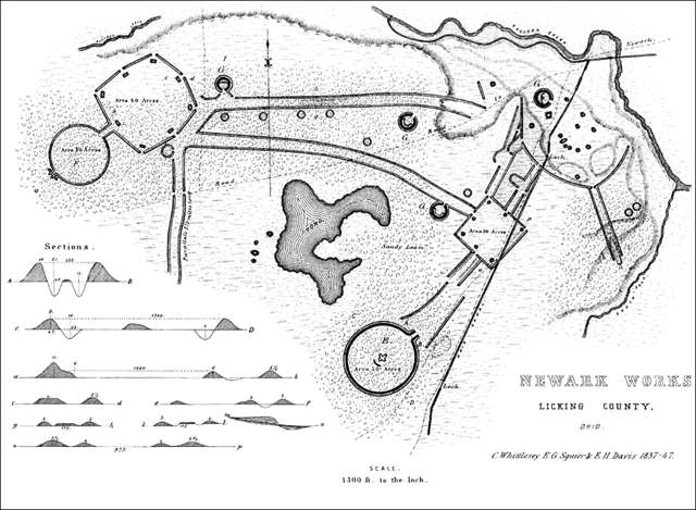
Photo: Ephraim G. Squier and Edwin H. Davis, public domain · Wikimedia Commons
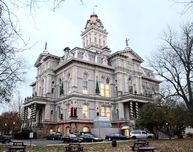
Photo: Tysto, via Wikimedia Commons, public domain · Wikimedia Commons
Local history sources: archive.org · en.wikipedia.org · en.wikipedia.org · en.wikipedia.org · en.wikipedia.org · en.wikipedia.org · commons.wikimedia.org · commons.wikimedia.org
Water
North Fork of the Licking River, drawn directly at riverbank intake screens beside the plant at the north end of Newark The water here
- Newark City98% of residentsNorth Fork Licking River
- Licking County Prescott Estates1% of residentsGroundwater wells (3 wells)
- Lakeshore Court Mobile Home1% of residentsGroundwater wells (1 wells)
- St. Louisville Village0% of residentsGroundwater wells (2 wells)
- City of Heath0% of residentslocal wells
- Winding Creek Estates0% of residentsGroundwater wells (1 wells)
- Valley Mobile Home Park0% of residentsGroundwater wells (2 wells)
- Wilkins Mobile Home Park0% of residentsGroundwater wells (2 wells)
Its ZIP codes
Each ZIP code that touches Newark Township, Licking County, with the share of its residents who live here and the same headline figures as the ZIP page.
| ZIP | Share | Water | Radon | Home value | Schools | Flood |
|---|---|---|---|---|---|---|
| 43055 Newark | 3% | North Fork of the Licking River, drawn directly at riverbank intake screens beside the plant at the north end of Newark | 11.5 pCi/L average radon | Median year built 1960 | Newark City · 2.5 stars overall | 6.1% of residents in the 1% floodplain |
The county
Licking County: 17 ZIP codes, 38 cities, villages and townships, 160,939 people.
Nearby places
Cite this page
Cite this page as:
Cracked Buckeye (Open Shower Co), "Newark Township, Licking County", https://crackedbuckeye.com/place/newark-township-licking-county/, built 2026-09-16, accessed [date].
Machine-readable: /api/place/newark-township-licking-county.json (open JSON, CC BY 4.0 for the compilation; the underlying records keep their own terms) · How to cite · Report a correction · Built 2026-09-16