How Madison Township, Franklin County began
Madison Township was organized on March 4, 1810 (the 1880 Franklin and Pickaway county history gives 1809) and named for President James Madison; its first settler, George Tongue, had arrived on George's Creek about 1802-1803, and settler families from Maryland, Pennsylvania, New Jersey, Nova Scotia and Kentucky followed within a few years. The Ohio and Erie Canal, dug through the township between 1828 and 1831, created both of its villages: Winchester (renamed Canal Winchester in 1841), platted by Reuben Dove in 1828 after the canal cut through his wheat field, and Groveport, formed in the winter of 1846-47 when the rival plats of Wert's Grove and Rarey's-port merged under a compromise name. Water shaped the township's history throughout: canal locks numbered 19 through 22 ran through it, Big Walnut and Little Walnut creeks powered its early grist and saw mills, and a cholera outbreak carried in on a canal boat killed about thirty residents in 1833. The township also produced John S. Rarey, the internationally famous horse-tamer who performed for Queen Victoria, and lost at least one early settlement, Middletown (renamed Oregon in 1830), when its post office closed around 1842. Today the township contains parts of Groveport, Canal Winchester, Obetz, Pickerington and Columbus, and was, by Bareis's 1902 account, the largest township in Franklin County by area.
Settled 1802 or 1803, incorporated 1810, by George Tongue, first settler, on George's Creek; the township was organized March 4, 1810, with Ebenezer Richards and George Hays elected as its first justices of the peace (the 1880 Franklin and Pickaway county history gives the organization year as 1809).
Where the name comes from
The land was first surveyed in 1799 by John Matthews and Ebenezer Buckingham as Range 21, Township 11 of the U.S. Congress Lands. For civil government it was organized in 1810 and named after James Madison, the fourth President of the United States, whose administration had just begun; Bareis's 1902 history notes that the surveyed-township numbering and the civil-township name follow different systems and are easily confused.
Before the town
Bareis's 1902 township history states plainly that, as far as could be learned, no Indian villages stood within Madison Township itself, though it records three specific traces. A flint-worker's shop was inferred near Asbury Church from a heavy scatter of flint chips found there. Early settlers in adjoining Violet Township, Fairfield County, remembered a village of twenty or thirty wigwams on the north bank of Little Walnut Creek about a mile east of Winchester, abandoned within a year or two of the first Euro-American settlers' arrival. And a trail linking 'To-be-town' (at Royalton) and 'Cranetown' (at Upper Sandusky) crossed the farm of Irvin E. Stevenson in the township. Bareis does not name a nation for any of these, but Upper Sandusky was the center of Wyandot settlement in Ohio from the 1810s into the 1840s (the Upper Sandusky Reservation, 1818-1842), which suggests the trail's northern end lay in Wyandot country; this is inference from a separate source, not a claim Bareis himself makes. Franklin County as a whole lies within the land the Wyandot, Shawnee, Lenape (Delaware), Miami, Ottawa and other nations of the Western Confederacy ceded to the United States at the 1795 Treaty of Greenville, placing Madison Township's land on the ceded side of the treaty line by the time of its first settlement in 1802-03. Fuller county-wide Native American context - prehistoric mound-building cultures, named villages, and the sequence of eighteenth- and nineteenth-century treaties - will be in the Franklin County file, not yet written.
Nations recorded here: Wyandot.
- Flint-worker's shop (inferred from flint-chip scatter) (other) — near Asbury Church, Madison Township, undated, pre-contact (archive.org)
- Wigwam village (remembered by early settlers, 20-30 dwellings) (village) — north bank of Little Walnut Creek, about one mile east of Winchester, in Violet Township, Fairfield County, just outside Madison Township, occupied to shortly after 1802-03 (archive.org)
- Trail from To-be-town (Royalton) to Cranetown (Upper Sandusky) (trail) — crossed the farm of Irvin E. Stevenson, Madison Township, pre-settlement into the early 1800s (archive.org)
Timeline
- — The Treaty of Greenville cedes most of Ohio, including the future Franklin County, to the United States, opening the land to Euro-American settlement.
- — George Tongue becomes the township's first settler, locating on George's Creek.
- — Families from Maryland, Pennsylvania, New Jersey, Nova Scotia and Kentucky settle the township, including the Kalb, Stevenson, Kramer, Rarey and Decker families.
- — Mathew Taylor builds the township's first grist and saw mill near the mouth of Alum Creek, and Lewis Kramer builds a second on Little Walnut Creek about the same time.
- — Madison Township is organized on March 4, with Ebenezer Richards and George Hays elected its first justices of the peace (the 1880 Franklin and Pickaway county history gives the year as 1809).
- — Isaac D. Decker plats Middletown, a village on the Columbus and Lancaster road that is renamed Oregon in 1830 and largely disappears after its post office closes about 1842.
- — Reuben Dove and John Colman plat the town of Winchester, recorded November 4-5, after Ohio and Erie Canal construction cuts through Dove's wheat field.
- — Active construction begins on the section of the Ohio and Erie Canal running through the township, with local landowners Adam Rarey, Reuben Dove, W. H. Richardson and Abraham Harrison bidding on individual sections.
- — The first canal boats, Cincinnati, Red Rover and Lady Jane, pass through the township on September 25 as the canal opens for navigation between Newark, Columbus and Circleville.
- — Cholera, apparently carried in on a canal traveler's laundry, breaks out near Winchester in late June and kills about thirty people within a few weeks before reaching Columbus in July.
- — The rival plats of Rarey's-port (recorded February 8, 1844) and Wert's Grove (recorded October 9, 1845) are laid out on adjoining land at the canal crossing.
- — Citizens merge the two rival village names into Groveport over the winter of 1846-47, incorporate it, and elect Abraham Shoemaker its first mayor on April 17.
- — Daily passenger trains begin running between Columbus and Lancaster through Groveport and Winchester on January 18, after the Columbus and Hocking Valley Railroad reached the township in 1868.
- — Groveport United Methodist Church is completed at 512 Main Street; it is later listed on the National Register of Historic Places.
Stories
The Wheat Field That Became a Town
Henry Dove entered the quarter section that became Winchester around 1802-1803 and, before his death, divided it between his sons Reuben and Jacob. When Ohio and Erie Canal surveyors marked a route straight through Reuben Dove's wheat field in 1827, he objected and talked of suing the state for damages to his crop. Workmen digging the canal suggested he lay out a town instead, reasoning there would be more money in selling lots than in a lawsuit, since the site sat roughly halfway between Lancaster and Columbus. Dove and his neighbor John Colman hired surveyor James O'Kane, and on November 4-5, 1828 they recorded the plat of Winchester, named for the Virginia town where Dove's father had once lived. Three years later, on September 25, 1831, the first canal boats reached the new town; crowds gathered for miles along the banks, and when the sound of a Lancaster brass band drifted up the towpath the cry went up, 'The boat is coming!' The village became Canal Winchester after its post office took that name in 1841, to distinguish it from five other Ohio towns called Winchester.
Two Villages, One Name
In 1832 Jacob B. Wert leased ground from Adam Rarey where the new Ohio and Erie Canal crossed the Lancaster and Columbus road, opening a warehouse and store. Wm. H. Rarey platted his own town, Rarey's-port, on the east side of the crossing in February 1844; Wert platted Wert's Grove on the west side in October 1845. Each man wanted the whole settlement to carry his name, and it was said that Wert quietly relabeled any mail addressed to 'Rarey's-port' so it read 'Wert's Grove' instead. Citizens met through the winter of 1846-47 to settle the dispute; one meeting even weighed naming the town Palo Alto, after a recent battle of the Mexican-American War, before Dr. Abel Clark proposed dropping both personal names and keeping only the last syllable of each. The compromise produced Groveport, which incorporated as a village that same winter and held its first election on April 17, 1847, electing Abraham Shoemaker its first mayor.
Cholera on the Towpath
In late June 1833 a canal-boat traveler from Cleveland stopped at a house about a mile and a half west of Winchester and asked Mrs. Woodcock to wash his clothes; the clothing, it was later believed, carried cholera. Mr. Woodcock went fishing on George's Creek, came home, drank buttermilk, and within hours fell violently ill; he and his wife were both dead within a day. Neighbors who gathered to help, not yet understanding the danger, carried the infection home with them, and within a few weeks about thirty people died in the same rural neighborhood, most within hours of showing symptoms. The outbreak reached Columbus by July 14 and continued into October, killing roughly two hundred people in a town of about three thousand, a third of whom had already fled to the countryside. By local account this Madison Township outbreak was cholera's first appearance in Franklin County.
The Groveport Boy Who Tamed Cruiser
John S. Rarey was born December 6, 1827, in his father Adam's log tavern just east of Groveport, the youngest of eleven children; by age twelve he was already known locally for training a pony his father had given him. After a financially unsuccessful start as a horse-tamer in Texas in 1855, Rarey sailed for England in 1857 with letters of introduction from Ohio's governor, and there he was asked to demonstrate his method on Cruiser, a blooded stallion so vicious he had been confined for three years in an iron-lined box stall. Rarey worked with the horse for about three hours and then rode him, tame, into London; he later bought Cruiser and brought him home to Groveport. His reputation carried him to Buckingham Palace, where he performed for Queen Victoria, Prince Albert and a hall of European royalty on the eve of the Princess Royal's wedding, and the queen herself stroked Cruiser's neck. The small instruction manuals Rarey sold to paying pupils for ten dollars a lesson were, Bareis notes, still being guarded as private property by Madison Township families when he wrote his history in 1902.
Oregon, the Town That Lost Its Name Twice
In 1817 Isaac D. Decker platted a village on the Columbus and Lancaster road and called it Middletown, for its position roughly halfway between the two cities. Two miles east, Frederick Baugher platted a rival stopping-place around 1815 called Centerville, for the same reason; it was later renamed Lithopolis. In 1830 Middletown itself was renamed Oregon, and guideposts were planted at nearby crossroads to direct travelers there; one sign, on the west side of the Oregon road, spelled the name backward as 'Nogero' so that, read in the direction of travel, it pointed the way. The township's first post office had opened at the settlement in 1829 under Dr. Hersey, passed to Isaac D. Decker in 1833, and closed for good around 1842. By the time Bareis wrote in 1902, only two or three buildings remained on the site, though older residents still called the place by its original name, Middletown.
Photographs
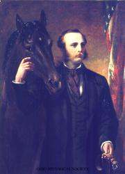
Photo: Miner Kilbourne Kellogg; Ohio Historical Society, public domain · Wikimedia Commons
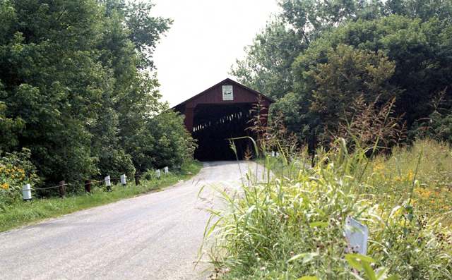
Photo: A. V. Shirk; Columbus Metropolitan Library via Digital Public Library of America, public domain · Wikimedia Commons
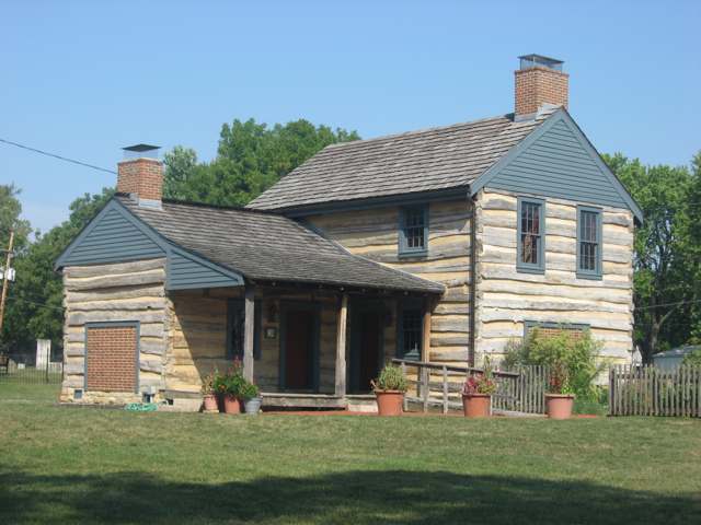
Photo: Nyttend, public domain · Wikimedia Commons
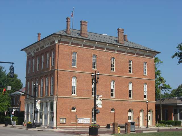
Photo: Nyttend, public domain · Wikimedia Commons
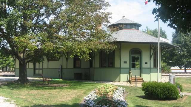
Photo: Nyttend, public domain · Wikimedia Commons
Local history sources: en.wikipedia.org · en.wikipedia.org · en.wikipedia.org · en.wikipedia.org · en.wikipedia.org · en.wikipedia.org · en.wikipedia.org · archive.org · archive.org · commons.wikimedia.org · commons.wikimedia.org · commons.wikimedia.org · commons.wikimedia.org · commons.wikimedia.org · commons.wikimedia.org
Water
South Well Field wells in Scioto valley sand and gravel, off Parsons Ave near Shadeville and Lockbourne The water here
- Columbus Public Water System77% of residentsScioto River (Griggs & O'Shaughnessy), Hoover Reservoir on Big Walnut Ck, plus wells
- Aqua Ohio - Blacklick15% of residentsGroundwater wells (3 wells)
- Groveport5% of residentsGroundwater wells (2 wells)
- Obetz Satellite 21% of residentsScioto River (Griggs & O'Shaughnessy), Hoover Reservoir on Big Walnut Ck, plus wells
- Obetz Village1% of residentsGroundwater wells (2 wells)
- Canal Winchester City1% of residentsLocal groundwater wells (Franklin Co.)
- Fairfield County Utilities0% of residentsLocal groundwater wells (central Ohio, aquifer undocumented)
- Lithopolis Village0% of residentsGroundwater wells (3 wells)
- Pickerington City0% of residentslocal buried-valley aquifer (wells near Diley Road)
- Reynoldsburg City0% of residentsScioto River (Griggs & O'Shaughnessy), Hoover Reservoir on Big Walnut Ck, plus wells
Its ZIP codes
Each ZIP code that touches Madison Township, Franklin County, with the share of its residents who live here and the same headline figures as the ZIP page.
The county
Franklin County: 45 ZIP codes, 42 cities, villages and townships, 1,356,733 people.
Nearby places
Cite this page
Cite this page as:
Cracked Buckeye (Open Shower Co), "Madison Township, Franklin County", https://crackedbuckeye.com/place/madison-township-franklin-county/, built 2026-09-16, accessed [date].
Machine-readable: /api/place/madison-township-franklin-county.json (open JSON, CC BY 4.0 for the compilation; the underlying records keep their own terms) · How to cite · Report a correction · Built 2026-09-16