How Hamilton Township, Franklin County began
Hamilton Township, in southern Franklin County along the Scioto and Big Walnut (Gahanna) creeks, was organized under its present name in 1807, a few years after the first settlers arrived around 1800. It lies within the Congress Lands survey, just west of the Refugee Tract. Its main village, Groveport, formed in 1846 when two rival canal towns, Wert's Grove and Rarey's Port, merged and incorporated the next year; the township also holds Lockbourne and Obetz. Today much of its northern and western area has been absorbed into Columbus, and it is home to Rickenbacker Air National Guard Base and the Scioto Downs racetrack.
Settled c. 1800, incorporated 1807.
Where the name comes from
No source found states why the township was given the name Hamilton. The 1880 county history says only that 'the township was organized under its present name in 1807,' when it still included the territory that later became Madison Township; it does not explain the choice of name.
Before the town
The 1880 county history devotes a section to 'Ancient Remains,' recording that Hamilton Township 'contains a number of mounds, or earthworks, the only records of the existence of a former race.' It describes an ancient fort or ditch on the west bank of the Gahanna (Big Walnut) Creek in section 34, 'almost completely obliterated' by 1880; two mounds a quarter mile apart on Thomas M. Clark's farm, one round and larger, one oblong and smaller, in which 'implements and human bones were found' when opened; and several more mounds elsewhere in the township whose builders were already a mystery to nineteenth-century residents. The source does not name a culture, but the mound-and-earthwork pattern matches the Adena and Hopewell mound-building traditions documented elsewhere in central Ohio. No named historic-era Native village, trail, or camp is recorded specifically within the township's bounds. The 1880 history states directly that 'Hamilton township is within the, so-called, Congress lands' — placing it just west of the Refugee Tract, the 103,527-acre strip granted to Canadian and Nova Scotian supporters of the American Revolution that ran along the south line of the U.S. Military District through Franklin, Fairfield, Licking and Perry counties. The land was opened to settlement by the Treaty of Greenville, signed August 3, 1795, in which the Wyandot, Lenape (Delaware), Shawnee, Ottawa, Ojibwe (Chippewa), Potawatomi, Miami and other nations ceded most of what is now Ohio to the United States; Lucas Sullivant founded Franklinton, the county's first permanent settlement, a few miles to the northwest in 1797.
Nations recorded here: Wyandot, Shawnee, Lenape (Delaware), Miami, Ottawa, Adena culture, Hopewell culture.
- Gahanna Creek earthwork (Section 34) (earthwork) — west bank of the Gahanna (Big Walnut) Creek, section 34, Hamilton Township, unknown (pre-contact) (ohiogenealogyexpress.com)
- Thomas M. Clark farm mounds (mound) — Thomas M. Clark's farm, Hamilton Township, unknown (pre-contact) (ohiogenealogyexpress.com)
Timeline
- — The Treaty of Greenville cedes most of what becomes Ohio, including the future Hamilton Township, to the United States.
- — Lucas Sullivant founds Franklinton, the first permanent settlement in what becomes Franklin County, a few miles northwest of the township.
- — John Dill, from York County, Pennsylvania, becomes probably the first settler in Hamilton Township, entering 1,200 acres in the north and northwest part.
- — Thomas Morris, who had surveyed the area in 1799, settles with his family; the Stambaugh family also arrives.
- — The township is organized under the name Hamilton, then still including the territory that later becomes Madison Township.
- — A Lutheran congregation organizes in the township; it builds a log meeting house in 1821 and a brick church in 1844.
- — The log house later known as the Groveport Log House is built.
- — The Rohr family arrives in the township on August 16.
- — John and Cornelius McCarthy build a sawmill at Shadeville.
- — Hamilton Presbyterian Church is built, organized by Rev. Dr. Hoge.
- — The rival canal towns of Wert's Grove and Rarey's Port merge to form Groveport, on the Ohio and Erie Canal.
- — Groveport is incorporated as a village and its post office opens.
- — St. Matthew's Evangelical Lutheran Church is built at Lockbourne.
- — The 1815 Groveport Log House is relocated near Groveport Cemetery for preservation.
Stories
Two Rival Towns on the Canal
When the Ohio and Erie Canal reached southern Franklin County in the 1830s, two small settlements grew up side by side on it: Wert's Grove and Rarey's Port, named for local landowning families. Rather than compete indefinitely, the two merged into a single town in 1846, and the combined village was incorporated the next year, 1847, when a post office named Groveport also opened. The Rarey and Wert families are still visible in the village today — Commons hosts modern photographs of both the Rarey House and the Jacob Wert House standing in Groveport. The canal that brought the two towns together is remembered with a historical marker in the village.
Mounds the Settlers Could Not Explain
When Hamilton Township's farms were cleared in the early 1800s, settlers found evidence that someone had lived on this land long before them. The 1880 county history records an old fort or ditch on the west bank of the Gahanna Creek in section 34, already 'almost completely obliterated,' and two burial mounds a quarter mile apart on Thomas M. Clark's farm — one round and larger, one oblong and smaller. When local residents opened the mounds they found human bones and implements inside, but no one in 1880 could say who had built them or when. Several smaller mounds elsewhere in the township are mentioned only in passing, suggesting the full extent of the township's ancient earthworks was never systematically recorded.
Mills on the Gahanna
Water power drove the township's earliest industry. Michael Fisher, one of the first settlers, built a sawmill on the Scioto in the northwest part of the township not long after he arrived from Virginia around 1800. Others followed on the Gahanna (Big Walnut) Creek: Joseph Murray and Isaac Weatherington ran a sawmill there, and John Herr and Francis Johnston combined a sawmill, gristmill, and distillery on the same stream. Decades later, in 1834, brothers John and Cornelius McCarthy built a sawmill at Shadeville, and the Cottage Mills were raised at the same crossroads in 1841 — evidence that the township's little mill villages kept growing well after the first pioneer generation had died out.
A Log House Moved to Save It
One of the township's oldest surviving buildings is a log house built in Groveport in 1815, back when the village was still two separate hamlets on the canal-to-be. As Groveport grew up around it across the nineteenth and twentieth centuries, the little building survived long enough to be recognized as historic, and in 1974 it was physically relocated to a new site near Groveport Cemetery to preserve it. It was later listed on the National Register of Historic Places as one of the Groveport Log Houses, alongside the Groveport Town Hall Historic Group and Groveport United Methodist Church, giving the merged canal town three separate National Register listings from its nineteenth-century core.
Photographs
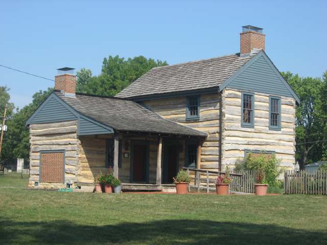
Photo: Nyttend, public domain · Wikimedia Commons
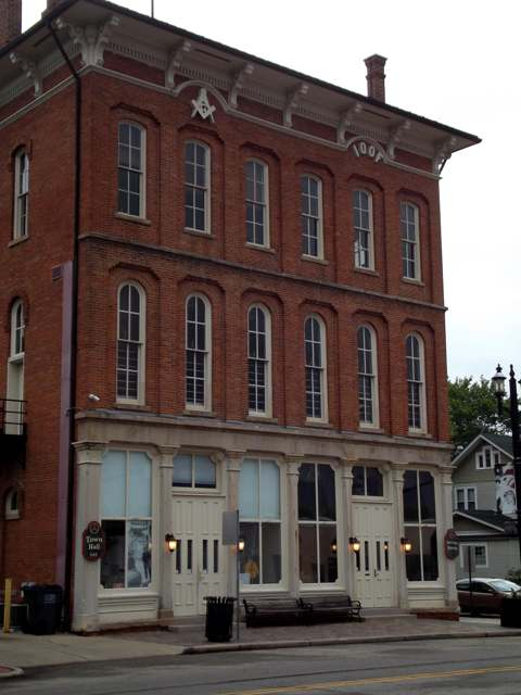
Photo: Central Avenue, via Wikimedia Commons, CC BY 4.0 · Wikimedia Commons
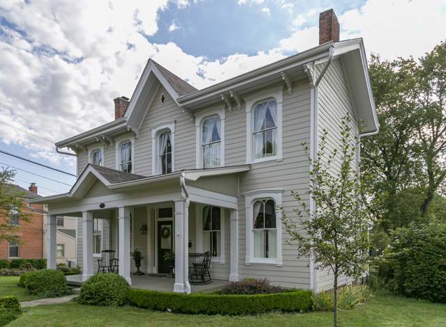
Photo: Pythaglio (Christopher Riley), via Wikimedia Commons, CC BY-SA 4.0 · Wikimedia Commons
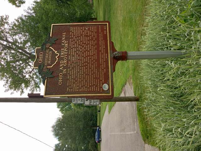
Photo: Nahida, via Wikimedia Commons, CC0 · Wikimedia Commons
Local history sources: ohiogenealogyexpress.com · en.wikipedia.org · en.wikipedia.org · en.wikipedia.org · en.wikipedia.org · en.wikipedia.org · commons.wikimedia.org · commons.wikimedia.org · commons.wikimedia.org · commons.wikimedia.org
Water
South Well Field wells in Scioto valley sand and gravel, off Parsons Ave near Shadeville and Lockbourne The water here
- Columbus Public Water System90% of residentsScioto River (Griggs & O'Shaughnessy), Hoover Reservoir on Big Walnut Ck, plus wells
- Obetz Village6% of residentsGroundwater wells (2 wells)
- Caravan Village MHP2% of residentsGroundwater wells (2 wells)
- Enchanted Acres MHP1% of residentsGroundwater wells (2 wells)
- Obetz Satellite 61% of residentsScioto River (Griggs & O'Shaughnessy), Hoover Reservoir on Big Walnut Ck, plus wells
- Lockbourne Village0% of residentsScioto River (Griggs & O'Shaughnessy), Hoover Reservoir on Big Walnut Ck, plus wells
- Obetz Satellite 10% of residentsScioto River (Griggs & O'Shaughnessy), Hoover Reservoir on Big Walnut Ck, plus wells
Its ZIP codes
Each ZIP code that touches Hamilton Township, Franklin County, with the share of its residents who live here and the same headline figures as the ZIP page.
| ZIP | Share | Water | Radon | Home value | Schools | Flood |
|---|---|---|---|---|---|---|
| 43137 Harrison Township and Lockbourne | 18% | South Well Field wells in Scioto valley sand and gravel, off Parsons Ave near Shadeville and Lockbourne | 9.5 pCi/L average radon | Median year built 1978 | Teays Valley Local · 4 stars overall | 9.3% of residents in the 1% floodplain |
| 43217 Columbus | 11% | South Well Field wells in Scioto valley sand and gravel, off Parsons Ave near Shadeville and Lockbourne | 4.1 pCi/L average radon | Median year built 1962 | Hamilton Local · 2.5 stars overall | 0.0% of residents in the 1% floodplain |
| 43207 Columbus | 6% | South Well Field wells in Scioto valley sand and gravel, off Parsons Ave near Shadeville and Lockbourne | 5.0 pCi/L average radon | Median year built 1962 | Columbus City · 2 stars overall | 1.5% of residents in the 1% floodplain |
The county
Franklin County: 45 ZIP codes, 42 cities, villages and townships, 1,356,733 people.
Nearby places
Cite this page
Cite this page as:
Cracked Buckeye (Open Shower Co), "Hamilton Township, Franklin County", https://crackedbuckeye.com/place/hamilton-township-franklin-county/, built 2026-09-16, accessed [date].
Machine-readable: /api/place/hamilton-township-franklin-county.json (open JSON, CC BY 4.0 for the compilation; the underlying records keep their own terms) · How to cite · Report a correction · Built 2026-09-16