How Obetz began
Obetz began in 1838 as a stagecoach-road crossroads called Obetz Junction in Hamilton Township, a stretch of Franklin County bounded on the west by the Scioto River, and took its name from Charles Obetz, an early landowning settler whose family's presence in the county is independently confirmed in the 1880 county history. Reese Station handled its rail traffic while neighboring Groveport, Lockbourne, and Canal Winchester grew up a short distance away on the Ohio and Erie Canal. Residents incorporated it as the village of Obetz in 1928, dropping "Junction" from the name, and the Lutheran congregation organized in the township as early as 1812 built the brick church on Groveport Road that is now listed on the National Register of Historic Places. Obetz stayed a small rail-and-farm village for most of the twentieth century until warehouse and logistics growth tied to nearby Rickenbacker International Airport pushed its population past 5,000, and it became a city in 2020.
Settled 1838, incorporated 1928, by Named for Charles Obetz, an early landowning settler in Hamilton Township; no single founder or platter of the village itself is documented in the sources reviewed.
Where the name comes from
Obetz takes its name from Charles Obetz, an early landowning settler in Hamilton Township. The community was first known as Obetz Junction, for its place at a stagecoach junction and later a rail junction, and dropped "Junction" when it incorporated as a village in 1928. A Charles and Catharine Obitz (a period spelling of the same name) appear independently in Franklin County's 1880 county history as the parents of a woman married in the county in 1857, confirming a family of that name was established there by the mid-nineteenth century, though the book does not place them in Hamilton Township specifically.
Before the town
No Native American village, camp, trail, mound, or earthwork has been documented by name within Obetz's own municipal boundaries. Hamilton Township, the larger jurisdiction Obetz was later carved from, is described in the 1880 "History of Franklin and Pickaway Counties, Ohio" as containing "a number of mounds, or earthworks -- the only records of the existence of a former race": a largely plowed-out ancient fort or ditch on the west bank of the Gahanna river (Big Walnut Creek, which flows into the Scioto within the township) in section thirty-four, and two burial mounds about a mile east of it on the farm of Thomas M. Clark, one round and one oblong, already dug into by 1880 with human bone and implements found inside. That source does not name a culture and does not place either site relative to the later village of Obetz; central Ohio earthworks of this kind are generally credited by archaeologists to the Adena (about 800 BC to AD 100) or Hopewell (100 BC to AD 500) mound-building traditions, but no source found here makes that identification for these particular sites. More broadly, the same county history places the historic-era Shawnee, who "had their greatest strength in the valleys of the Scioto and Mad rivers," as the dominant nation of the Scioto valley in which Obetz sits, alongside Wyandot (Huron), Lenape (Delaware), Mingo (an offshoot of the Six Nations, ancestral to today's Seneca-Cayuga), and Miami bands who also traveled and camped in the valley before 1795. The Treaty of Greenville, concluded August 3, 1795, ended the fighting that had kept United States survey and settlement out of this part of Ohio and opened the way for the 1807 organization of Hamilton Township. Because none of this is tied to a specific place within modern Obetz, fuller county-wide detail on named villages, leaders, and later treaties belongs in the Franklin County file (data/history/counties/Franklin.json).
- Ancient fort or ditch on the Gahanna river (Big Walnut Creek) (earthwork) — West bank of the Gahanna river (now called Big Walnut Creek), section 34, Hamilton Township, Franklin County -- a township-wide location only; the 1880 source does not place it relative to modern Obetz, Unattributed by the source; central Ohio earthworks of this form are commonly linked by archaeologists to the Adena or Hopewell mound-building traditions (archive.org)
- Two burial mounds on the Thomas M. Clark farm (mound) — About one mile east of the Gahanna river earthwork, Hamilton Township, Franklin County -- a township-wide location only, not placed relative to modern Obetz, Unattributed by the source (archive.org)
Timeline
- — The Treaty of Greenville is concluded on August 3, ending the Northwest Indian War and opening the Scioto valley, including the future Hamilton Township, to United States land survey and settlement.
- — Hamilton Township, from which Obetz was later formed, is organized under its present name within Franklin County's Congress Lands, bounded on the west by the Scioto River.
- — The Reverend M. Foster begins preaching to German Lutheran and Reformed families in Hamilton Township; within about two years they organize formally, with Philip Helsel, G. Kissinger, Michael Stimmel, and Nicholas Young among the founding elders and wardens.
- — A stagecoach-road crossroads in Hamilton Township is settled and becomes known as Obetz Junction, named for settler Charles Obetz.
- — A local cemetery history gives 1843 as the founding of the Lutheran cemetery beside the Hamilton Township church, with some burials reportedly earlier still, "when the church was just a little log cabin"; standard Ohio cemetery references instead list the establishment date as 1868.
- — The Hamilton Township Lutheran and Reformed congregation, meeting since 1812, builds its first brick church under pastor Philip Gast.
- — Catharine, daughter of Charles and Catharine Obitz, marries Franklin County commissioner Isaac S. Beekey on April 23 -- the earliest independently documented record found of the Obetz family (spelled "Obitz") in Franklin County.
- — The Hamilton Township Lutheran congregation erects a larger brick church costing about nine thousand dollars, dedicated June 7, 1874; the building still stands on Groveport Road in Obetz.
- — The community incorporates as the village of Obetz, dropping "Junction" from its earlier name of Obetz Junction.
- — Zion's Evangelical Lutheran Church at 4501 Groveport Road, Obetz, is listed on the National Register of Historic Places on June 16 (reference number 04000609).
- — Obetz's population passes the 5,000 mark and the village becomes a city under Ohio law.
Stories
From Obetz Junction to a City
Obetz began as an informal stagecoach crossroads in Hamilton Township in 1838, taking its name from Charles Obetz, an early landowner whose family's presence in Franklin County is confirmed independently: the 1880 county history records a Charles and Catharine Obitz (a common period spelling) as the parents of a bride married in the county in 1857. For nearly a century the place was known as Obetz Junction, sitting near, but not directly on, the Ohio and Erie Canal towns of Groveport, Lockbourne, and Canal Winchester, while Reese Station handled its rail traffic. Residents incorporated it as the village of Obetz in 1928, quietly dropping "Junction" from the name. It stayed a small rail-and-farm village through most of the twentieth century; only after industrial and logistics growth tied to nearby Rickenbacker International Airport pulled its population past five thousand did Obetz cross the state's population threshold to become a city, in 2020.
The Lutheran Church at the Crossroads
In 1812 the Reverend M. Foster, an Evangelical Lutheran minister, began preaching in the homes of German Lutheran and Reformed families scattered across Hamilton Township. Within about two years they organized formally as the German Lutheran and Reformed Congregation of the Township of Hamilton, with Philip Helsel and G. Kissinger chosen as elders and Michael Stimmel and Nicholas Young as wardens. The congregation built a log meetinghouse in 1821, its first brick church in 1844 under pastor Philip Gast, and, after outgrowing that building, a larger brick church in 1873 that cost about nine thousand dollars and was dedicated June 7, 1874, with services held on alternating Sundays in English and German. That 1873 building, at 4501 Groveport Road, was listed on the National Register of Historic Places in 2004 as Zion's Evangelical Lutheran Church, and the cemetery beside it holds Helsel and Stimmel graves among its earliest. A local cemetery history states that the congregation was later rededicated as Obetz Christian Church in 1962, though how that later identity relates to the Lutheran congregation named in the 2004 National Register listing is not explained in the sources found here and would repay a closer look at church or diocesan records.
A Bear Hunt in Hamilton Township
Wild game was still common in the woods and clearings around the future Obetz well into the early nineteenth century, though black bears had grown scarce enough that a sighting was an event. About 1818, according to the 1880 county history, a bear was spotted by Jacob Hamler stalking one of George Rohr's hogs near his house. Hamler ran for help, and a party of neighbors armed with guns and axes and trailed by dogs chased the animal for about a mile until it climbed a large black oak tree. By the time the men caught up it was too dark to shoot accurately, so they built a bonfire, poured a volley of bullets into the bear, cut down the tree it had climbed, and found the animal dead with sixteen bullet holes in its body; the neighborhood held a barbecue the next day. The story is set in Hamilton Township generally rather than at a spot that can be pinned to modern Obetz, but it is one of the few surviving glimpses of everyday pioneer life in the area before the rail junction, or the Obetz name, existed.
Photographs
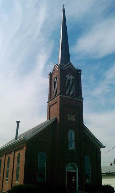
Photo: Strongdar, via Wikimedia Commons (Wiki Loves Monuments 2012), CC BY-SA 3.0 · Wikimedia Commons
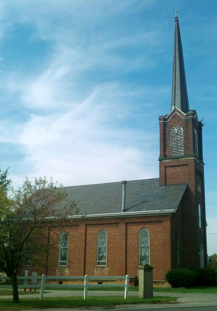
Photo: Strongdar, via Wikimedia Commons (Wiki Loves Monuments 2012), CC BY-SA 3.0 · Wikimedia Commons
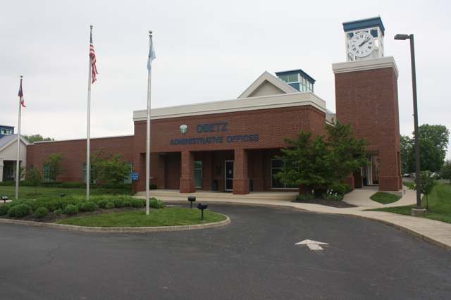
Photo: JacobGifford, via Wikimedia Commons, CC BY-SA 4.0 · Wikimedia Commons
Local history sources: en.wikipedia.org · en.wikipedia.org · en.wikipedia.org · en.wikipedia.org · obetz.gov · obetzhistorians.org · obetzhistorians.org · archive.org · genealogybug.net · genealogybug.net · commons.wikimedia.org · commons.wikimedia.org · commons.wikimedia.org · commons.wikimedia.org
Water
South Well Field wells in Scioto valley sand and gravel, off Parsons Ave near Shadeville and Lockbourne The water here
- Columbus Public Water System83% of residentsScioto River (Griggs & O'Shaughnessy), Hoover Reservoir on Big Walnut Ck, plus wells
- Obetz Village7% of residentsGroundwater wells (2 wells)
- Groveport6% of residentsGroundwater wells (2 wells)
- Obetz Satellite 22% of residentsScioto River (Griggs & O'Shaughnessy), Hoover Reservoir on Big Walnut Ck, plus wells
- Enchanted Acres MHP1% of residentsGroundwater wells (2 wells)
- Obetz Satellite 61% of residentsScioto River (Griggs & O'Shaughnessy), Hoover Reservoir on Big Walnut Ck, plus wells
- Obetz Satellite 10% of residentsScioto River (Griggs & O'Shaughnessy), Hoover Reservoir on Big Walnut Ck, plus wells
- Caravan Village MHP0% of residentsGroundwater wells (2 wells)
- Lockbourne Village0% of residentsScioto River (Griggs & O'Shaughnessy), Hoover Reservoir on Big Walnut Ck, plus wells
Its ZIP codes
Each ZIP code that touches Obetz, with the share of its residents who live here and the same headline figures as the ZIP page.
The county
Franklin County: 45 ZIP codes, 42 cities, villages and townships, 1,356,733 people.
Nearby places
Cite this page
Cite this page as:
Cracked Buckeye (Open Shower Co), "Obetz, Franklin County", https://crackedbuckeye.com/place/obetz/, built 2026-09-16, accessed [date].
Machine-readable: /api/place/obetz.json (open JSON, CC BY 4.0 for the compilation; the underlying records keep their own terms) · How to cite · Report a correction · Built 2026-09-16