Local events in Jackson Township, Jackson County
Nothing is posted for Jackson Township itself yet; here is what is on within 10 miles. All local events in Jackson Township, Jackson County
Know a calendar we should watch? Send the link
Checked October 20; the events page is refreshed daily.
How Jackson Township, Jackson County began
Jackson Township, in the northwest corner of Jackson County, was created by the commissioners on July 1, 1816 as one of the county's first townships and named for Andrew Jackson. The land was surveyed in 1799 (Thomas Worthington and J. B. Finley) and March 1801 (Jesse Spencer). Its best-known landmark is the Leo Petroglyph, a sandstone slab carved with 37 human and animal figures, possibly by Fort Ancient people AD 1000-1650, which has had a New Deal shelter since the 1930s. The 1900 county history also records 'Camp Rock', a boulder on Salt Creek carved 'Camp of 1812'. The township had 410 people in 1840, 1,869 in 1880 and 1,214 in 2020 and has no village.
Incorporated 1816-07-01 (created by the Jackson County commissioners), by Jackson County commissioners, on the petition of the inhabitants.
Where the name comes from
Named for Andrew Jackson, as the county was; the 1900 county history groups it with Hamilton and Clinton as townships named for 'three distinguished Americans'. One of thirty-seven Jackson Townships in Ohio.
Before the town
The township's defining Native American site is the Leo Petroglyph, a sandstone panel west of the community of Leo with 37 images of human figures, animals and footprints, possibly carved by people of the Fort Ancient culture around AD 1000-1650; the slab measures about 20 by 16 feet on the edge of a Mississippian sandstone cliff and its meaning is unknown. It was listed on the National Register on November 10, 1970 and is maintained by the Ohio History Connection. No treaty or historic-era village is placed in the township; for the Shawnee and the Scioto salt licks, and the county's mounds and rock shelters.
Nations recorded here: Fort Ancient culture, Shawnee.
- Leo Petroglyph (other) — Sandstone cliff west of Leo, Jackson Township, possibly AD 1000-1650 (Fort Ancient) (en.wikipedia.org)
Timeline
- — Thomas Worthington, assisted by J. B. Finley (later a noted Methodist preacher), surveys part of township 7, range 20, now in Jackson Township.
- — Jesse Spencer surveys township 8, range 19, the rest of the future Jackson Township.
- — General Tupper's army is supposed to have camped a night by a sandstone boulder on Salt Creek near the old Stinson tavern, later carved 'Camp of 1812' and called Camp Rock.
- — The commissioners incorporate Jackson Township as a new township in the northwest corner of the county 'and be called Jackson'.
- — Jackson Township's population is 410 in the federal census.
- — Jackson Township's population is 1,869, more than four times the 1840 count.
- — A wooden shelter is built over the Leo Petroglyph as a Works Progress Administration project.
- — The Leo Petroglyph is listed on the National Register of Historic Places.
- — The census counts 1,214 people in the township.
Stories
Thirty-seven figures on a sandstone slab
On a low sandstone cliff west of the crossroads community of Leo, a 20-by-16-foot slab carries 37 carved images: human figures, animals and footprints. Wikipedia attributes them to the Fort Ancient culture, possibly AD 1000-1650, making them older than any European presence in the Ohio country. The Ohio History Connection maintains the site, which is sheltered under a wooden roof built as a Works Progress Administration project, and the National Register listed it in 1970. What the carvings meant to the people who made them is unknown.
Camp Rock on Salt Creek
County historian Williams visited a huge sandstone boulder beside the road near the old Stinson tavern on Salt Creek in 1895 and wrote down what he saw. It had broken off the hill centuries before and lodged on the creek bank, about fifty feet long, fifteen thick and twenty high, with the road running between rock and hill as it always had. Cut deep into the face toward the road were the words CAMP OF 1812. General Tupper and his army, he wrote, were supposed to have camped a night near it, where the creek is fordable and a spring used to flow; old citizens claimed the names of soldiers had once been carved there too, but they had worn away. A blast had taken stone from the east end for a bridge abutment a year or two earlier.
Photographs
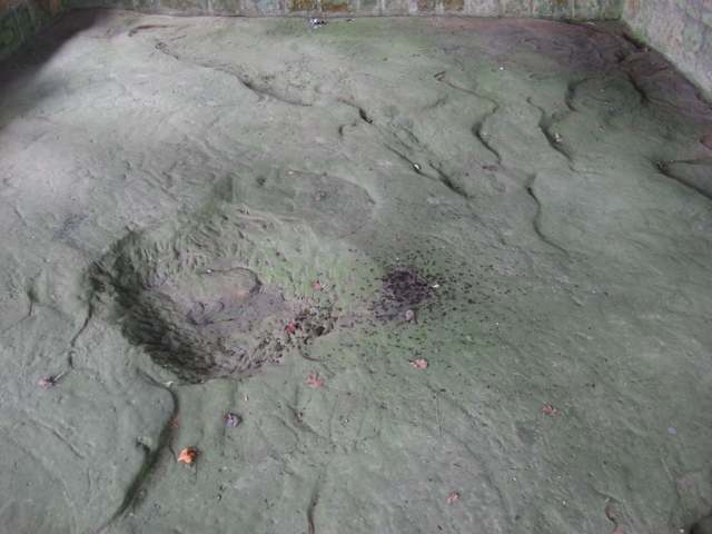
Photo: Nyttend, public domain · Wikimedia Commons
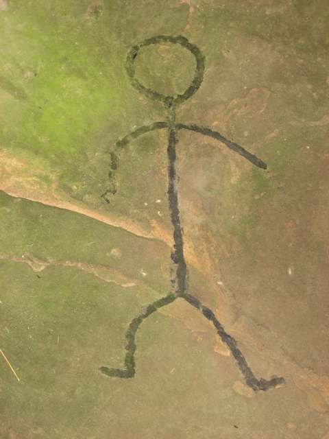
Photo: Nyttend, public domain · Wikimedia Commons
Local history sources: en.wikipedia.org · en.wikipedia.org · en.wikipedia.org · jackson.ohgenweb.org · en.wikipedia.org · archive.org · genealogytrails.com · npgallery.nps.gov · commons.wikimedia.org · commons.wikimedia.org
Water
Mostly private wells The water here
- Ross County Water Co. Inc62% of residentsTeays Valley Aquifer (buried valley groundwater)
- Jackson, City Of23% of residentsJisco Lake + Hammertown Lake (Jackson City Reservoir)
- Wellston City15% of residentsLake Rupert + Lake Alma (Little Raccoon Creek reservoirs)
- Coalton0% of residentsTeays River Buried Valley Aquifer (own wells)
Hospitals, fire stations and more
Inside Jackson Township, Jackson County's boundary: 4 poor-rated bridges and 6 spill cases. Press a pin or a name for its whole record and its source.
Bridges rated poor (4)
-
Brohard Rd over Pigeon CreekPoor · built 1955
- Condition
- Poor: a deck, superstructure, substructure or culvert rated 4 or below on the 0 to 9 scale
- What it is
- Bridge
- Built
- 1955
- Length
- 16 ft
- Owner
- County
- Vehicles a day
- 324
- Coordinates
- 39.14538, -82.75136
National Bridge Inventory (source) ↗ Street map and directions ↗
-
Bronx Corners over Trib To L Salt CrPoor · built 1945
- Condition
- Poor: a deck, superstructure, substructure or culvert rated 4 or below on the 0 to 9 scale
- What it is
- Bridge
- Built
- 1945
- Length
- 7 ft
- Owner
- County
- Vehicles a day
- 223
- Coordinates
- 39.18758, -82.75144
National Bridge Inventory (source) ↗ Street map and directions ↗
-
Perkins Road over Poplar RunPoor · built 1960
- Condition
- Poor: a deck, superstructure, substructure or culvert rated 4 or below on the 0 to 9 scale
- What it is
- Bridge
- Built
- 1960
- Length
- 13 ft
- Owner
- County
- Vehicles a day
- 106
- Coordinates
- 39.12254, -82.75805
National Bridge Inventory (source) ↗ Street map and directions ↗
-
Springer Rd over Pigeon CrPoor · built 1901
- Condition
- Poor: a deck, superstructure, substructure or culvert rated 4 or below on the 0 to 9 scale
- What it is
- Bridge
- Built
- 1901
- Length
- 20 ft
- Owner
- County
- Vehicles a day
- 324
- Coordinates
- 39.16274, -82.76312
National Bridge Inventory (source) ↗ Street map and directions ↗
Source: FHWA National Bridge Inventory 2025. "Poor" means one major part rated 4 or below on the 0 to 9 scale; it calls for repair, not closing, unless the state posts or closes the bridge.
Spills reported since 2021 (6)
-
Fuel Diesel / Diesel Fuel (Vehicle On Or Off Road)2025-11-07 · Jackson Twp
- Reported
- 2025-11-07
- What spilled
- Fuel Diesel / Diesel Fuel (Vehicle On Or Off Road)
- Where
- Jackson Twp, Jackson County
- Ohio EPA district office
- SEDO
- Ohio EPA case number
- 2511EPA0001820
Ohio EPA spill reports (source) ↗ Street map and directions ↗
-
Fuel Diesel / Diesel Fuel (Vehicle On Or Off Road)2024-04-13 · Jackson Twp
- Reported
- 2024-04-13
- What spilled
- Fuel Diesel / Diesel Fuel (Vehicle On Or Off Road)
- Largest amount reported
- 100 gallons
- Where
- Jackson Twp, Jackson County
- Ohio EPA district office
- SEDO
- Ohio EPA case number
- 2404EPA0000610
Ohio EPA spill reports (source) ↗ Street map and directions ↗
-
Other / All Other / Trade Name / Mixture / Solution Etc2023-07-10 · Jackson Twp
- Reported
- 2023-07-10
- What spilled
- Other / All Other / Trade Name / Mixture / Solution Etc
- Where
- Jackson Twp, Jackson County
- Ohio EPA district office
- SEDO
- Ohio EPA case number
- 2307EPA0001146
Ohio EPA spill reports (source) ↗ Street map and directions ↗
-
Fuel Diesel / Diesel Fuel (Vehicle On Or Off Road)2023-01-03 · Jackson Twp
- Reported
- 2023-01-03
- What spilled
- Fuel Diesel / Diesel Fuel (Vehicle On Or Off Road)
- Largest amount reported
- 15 gallons
- Where
- Jackson Twp, Jackson County
- Ohio EPA district office
- SEDO
- Ohio EPA case number
- 2301EPA0000010
Ohio EPA spill reports (source) ↗ Street map and directions ↗
-
Fuel Diesel / Diesel Fuel (Vehicle On Or Off Road)2021-10-04 · Jackson Twp
- Reported
- 2021-10-04
- What spilled
- Fuel Diesel / Diesel Fuel (Vehicle On Or Off Road)
- Largest amount reported
- 50 gallons
- Where
- Jackson Twp, Jackson County
- Ohio EPA district office
- SEDO
- Ohio EPA case number
- 2110EPA0001572
Ohio EPA spill reports (source) ↗ Street map and directions ↗
-
Fuel Diesel / Diesel Fuel (Vehicle On Or Off Road) Reached water2021-04-29 · Jackson Twp
- Reported
- 2021-04-29
- What spilled
- Fuel Diesel / Diesel Fuel (Vehicle On Or Off Road)
- Largest amount reported
- 50 gallons
- Reached a waterway
- 99 - Unnamed
- Where
- Jackson Twp, Jackson County
- Ohio EPA district office
- SEDO
- Ohio EPA case number
- 2104EPA0000585
Ohio EPA spill reports (source) ↗ Street map and directions ↗
Source: Ohio EPA emergency response spill reports, 2021 to September 2026, one point per case where Ohio EPA placed it. A report is what the caller or responder recorded; amounts are often blank or estimated.
Its ZIP codes
Each ZIP code that touches Jackson Township, Jackson County, with the share of its residents who live here and the same headline figures as the ZIP page.
| ZIP | Share | Water | Radon | Home value | Schools | Flood |
|---|---|---|---|---|---|---|
| 45672 Jackson Township and Ray | 48% | Mostly private wells | Too few radon tests | Median year built 1986 | Vinton County Local · 3 stars overall | No digital FEMA flood map for this county |
| 45640 Jackson | 1% | Hammertown Lake (primary); Jisco Lake (backup) | 2.4 pCi/L average radon | Median year built 1971 | Jackson City · 3.5 stars overall | 4.3% of residents in the 1% floodplain |
| 45692 Wellston | 1% | Surface water from Raccoon Creek, Lake Alma reservoir and Lake Rupert reservoir; built about 1927 and expanded in 1967; approved capacity 2.2 MGD. | 0.8 pCi/L average radon | Median year built 1955 | Wellston City · 3.5 stars overall | 3.1% of residents in the 1% floodplain |
The county
Vinton County: 7 ZIP codes, 13 cities, villages and townships, 11,430 people.
Nearby places
Quick answers
What county is Jackson Township, Ohio in?
Jackson Township, Jackson County is a township in Vinton County, Ohio, with 1,205 residents.
When was Jackson Township, Ohio founded?
Jackson Township, Jackson County was incorporated 1816-07-01 (created by the Jackson County commissioners). Founders on record: Jackson County commissioners, on the petition of the inhabitants. Source
How did Jackson Township, Ohio get its name?
Named for Andrew Jackson, as the county was; the 1900 county history groups it with Hamilton and Clinton as townships named for 'three distinguished Americans'. Source
What ZIP code is Jackson Township, Ohio?
Most of Jackson Township, Jackson County is in ZIP code 45672.
Where does Jackson Township, Ohio get its water?
The main water source for Jackson Township, Jackson County (Ross County Water Co. Inc): Mostly private wells.
Cite this page
Cite this page as:
Cracked Buckeye, "Jackson Township, Jackson County", https://crackedbuckeye.com/place/jackson-township-jackson-county/, built 2026-10-31, accessed [date].
How to cite · Report a correction · Built 2026-10-31
