Local events in Wellston
Nothing is posted for Wellston itself yet; here is what is on within 20 miles. All local events in Wellston
Know a calendar we should watch? Send the link
Checked October 20; the events page is refreshed daily.
How Wellston began
Wellston was laid out in 1873 in northeastern Jackson County on land owned by Harvey Wells, who built a blast furnace here in 1874 and aimed to make the town a regional industrial center; it was incorporated in 1876. The furnace and local coal mining drove rapid growth, and the town rebuilt after a major fire in 1888. Wellston's population peaked at 8,045 in 1900 before the coal and iron resources that built it were largely worked out, and it has since settled into a smaller, quieter city of about 5,400.
Settled 1873, platted 1873, incorporated 1876, by Harvey Wells.
Where the name comes from
Wellston is named for its founder, Harvey Wells, who laid out the town in 1873 on land he owned.
Before the town
No source found records a Native village, mound, trail, or specific encounter on the site that became Wellston; the town was founded in 1873, decades after the Treaty of Greenville (1795) ended Native land claims in this part of Ohio. At the county level, Jackson County was Mingo, Lenape (Delaware), and Shawnee territory before removal, and Native people worked the Scioto Salt Licks near Jackson for salt for thousands of years — but nothing specific to the Wellston site itself is recorded in the sources checked.
Nations recorded here: Mingo (Seneca-Cayuga), Lenape (Delaware), Shawnee.
Timeline
- — Wellston is laid out and founded on land owned by Harvey Wells.
- — Harvey Wells builds a blast furnace at Wellston, anchoring the town's early iron economy.
- — The town of Wellston is incorporated.
- — The Harvey Wells House is built at 403 (later addressed 407) E. A St.
- — A widespread fire destroys much of Wellston; the town is rebuilt afterward.
- — Harvey Wells dies chronically in debt; his furniture is sold off to help settle his estate, though he never personally owned the house that bears his name.
- — Wellston's population peaks at 8,045.
- — The Clutts House, home of industrialist Joseph Clutts, is built at 16 E. Broadway St.
- — The Morgan Mansion, home of industrialist T. J. Morgan, is built at Broadway and Pennsylvania Aves.; it later becomes Wellston's city hall.
- — The Morgan Mansion is listed on the National Register of Historic Places (February 16).
- — The Clutts House is listed on the National Register of Historic Places (November 26).
- — The Harvey Wells House is listed on the National Register of Historic Places (April 14).
Stories
The founder who never owned his own house
Harvey Wells set out in the 1870s to build the leading city of northeastern Jackson County, and by most measures he succeeded: he laid out the town in 1873, put up a blast furnace in 1874, saw it incorporated in 1876, and rebuilt it after a fire tore through it in 1888. But Wells ran his ambitions on borrowed money. He was chronically in debt for most of his life, and when he died in 1896 his own furniture had to be auctioned to help pay down what he owed his creditors. The grand Victorian and Italianate house at 403 E. A St. that carries his name and now sits on the National Register was, by the record, never actually his own property — a small irony at the center of the city he founded.
Two mansions of the iron trade
Wellston's short boom produced two grand houses that still anchor the town. Joseph Clutts, who arrived in 1882 and became a leading figure in the Wellston Iron and Steel Company he organized in 1896, built a buff-brick, tile-roofed house at 16 E. Broadway in 1902. Three years later T. J. Morgan, another of the county's leading industrialists, commissioned Columbus architect Wilbur Mills to design a Jacobethan-and-Spanish-Mission mansion at Broadway and Pennsylvania. Both houses outlasted the industries that paid for them: the Morgan Mansion today serves as Wellston's city hall.
Photographs
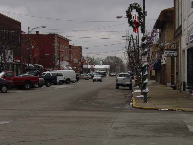
Photo: dankeck, CC0 · Wikimedia Commons
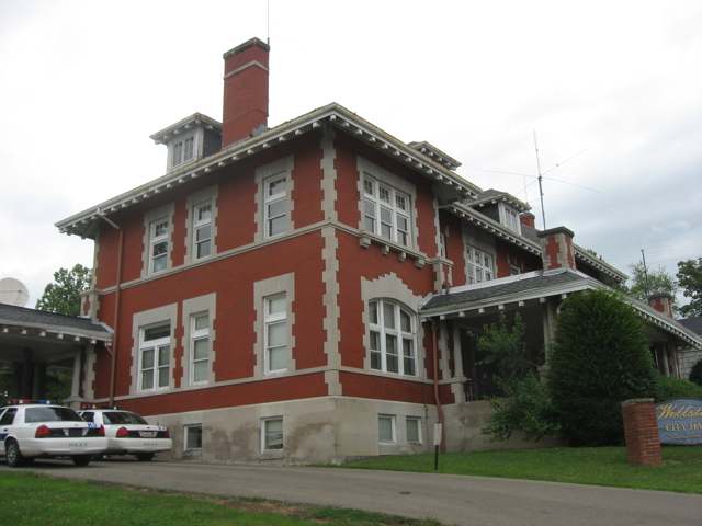
Photo: Nyttend, public domain · Wikimedia Commons
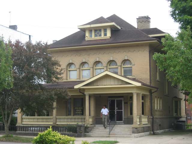
Photo: Nyttend, public domain · Wikimedia Commons
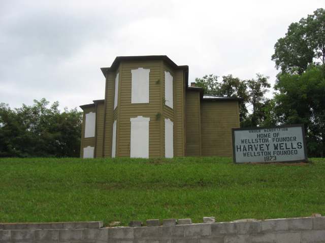
Photo: Nyttend, public domain · Wikimedia Commons
Local history sources: en.wikipedia.org · en.wikipedia.org · en.wikipedia.org · en.wikipedia.org · en.wikipedia.org · en.wikipedia.org · commons.wikimedia.org · commons.wikimedia.org · commons.wikimedia.org · commons.wikimedia.org
Historic places
3 places in Wellston on the National Register of Historic Places. Press a pin or a name for its whole record.
-
Clutts HouseBuilding · Wellston · listed 1980
- Address
- 16 E. Broadway St.
- Where
- Wellston, Jackson County · ZIP 45692
- What it is
- Building
- Listed on the National Register
- 1980
- NRIS reference number
- 80003105
- Coordinates
- 39.12376, -82.53438
National Register file (NPS) ↗ Search Wikipedia ↗ Street map and directions ↗ On the Cracked Buckeye map
-
Morgan MansionBuilding · Wellston · listed 1979
- Address
- Broadway and Pennsylvania Aves.
- Where
- Wellston, Jackson County · ZIP 45692
- What it is
- Building
- Listed on the National Register
- 1979
- NRIS reference number
- 79001867
- Coordinates
- 39.12364, -82.53287
National Register file (NPS) ↗ Search Wikipedia ↗ Street map and directions ↗ On the Cracked Buckeye map
-
Wells, Harvey, HouseBuilding · Wellston · listed 2009
- Address
- 403 E. A St.
- Where
- Wellston, Jackson County · ZIP 45692
- What it is
- Building
- Listed on the National Register
- 2009
- NRIS reference number
- 09000211
- Coordinates
- 39.12444, -82.53013
National Register file (NPS) ↗ Search Wikipedia ↗ Street map and directions ↗ On the Cracked Buckeye map
Source: National Park Service, National Register of Historic Places point file. The listing year is shown where NPS's certification date agrees with the listing's reference number. Listing recognizes significance; it does not restrict a private owner.
Water
Surface water from Raccoon Creek, Lake Alma reservoir and Lake Rupert reservoir; built about 1927 and expanded in 1967; approved capacity 2.2 MGD. The water here
- Wellston City97% of residentsLake Rupert + Lake Alma (Little Raccoon Creek reservoirs)
- Jackson, City Of2% of residentsJisco Lake + Hammertown Lake (Jackson City Reservoir)
- Coalton1% of residentsTeays River Buried Valley Aquifer (own wells)
Hospitals, fire stations and more
Inside Wellston's boundary: 1 nursing home, 1 fire or EMS station, 1 high-hazard dam, 4 public schools, 1 poor-rated bridge, 1 library, 1 museum, 1 police station, 1 Superfund site, 2 Toxics Release Inventory facilities and 16 spill cases. Press a pin or a name for its whole record and its source.
Nursing homes (1)
-
Edgewood Manor of Wellston5 of 5 stars · Wellston
- Address
- 405 North Park Avenue, Wellston, OH 45692
- Certified beds
- 50
- Residents on an average day
- 45
- Medicare overall rating
- 5 of 5 stars
- Health inspections
- 4 of 5 stars
- Staffing
- 2 of 5 stars
- Quality measures
- 5 of 5 stars
- Penalties since 2023
- 1 fine totalling $18,655 (latest 2024-07-31)
- Ownership
- For profit - Corporation
- Chain
- AOM HEALTHCARE
- Takes
- Medicare and Medicaid
- Phone
- (740) 384-5611
- Medicare ID
- 365939
Medicare Care Compare ↗ CMS nursing home data (source) ↗ Street map and directions ↗
Source: CMS Care Compare nursing home provider and penalties files; Medicare star ratings run 1 to 5.
Fire and EMS stations (1)
-
Wellston Fire Department Station 1Wellston
- Address
- 200 North Pennsylvania Avenue, Wellston, OH 45692
- Coordinates
- 39.12550, -82.53240
USGS National Map structures (source) ↗ Street map and directions ↗
Source: USGS National Map structures (most Ohio records last updated 2019 to 2022), checked against the Columbus and Cleveland station lists. The department that answers a call is set by jurisdiction and mutual aid, not by distance.
High-hazard dams (1)
-
Wellston Reservoir Dam PoorTributary To Little Raccoon Creek · condition: poor
- Hazard class
- High: a failure would probably cost a life
- Condition
- Poor (assessed 05/11/2021)
- River or stream
- Tributary To Little Raccoon Creek
- Purpose
- Water Supply
- Type
- Earth
- Height
- 41 ft
- Storage
- 95 acre-feet
- Completed
- 1920
- Owner type
- Local Government
- County
- Jackson County
- Nearest town (NID)
- Ratchford
- Last inspection
- 05/11/2021
- Emergency action plan
- Yes
- NID ID
- OH00813
National Inventory of Dams record ↗ National Inventory of Dams (source) ↗ Street map and directions ↗
Source: U.S. Army Corps of Engineers National Inventory of Dams, August 2026. "High hazard" rates what a failure would cost downstream, not how likely one is; the condition is the state's assessment.
Public schools (4)
-
Bundy Elementary School2 of 5 stars · Wellston
- Address
- 527 S Missouri Ave, Wellston, OH 45692
- School district
- Wellston City School District
- Kind (NCES)
- Regular School
- Students, 2023-24
- 333
- Teachers (full-time equivalent)
- 18.5
- Report card, 2025-26
- 2 of 5 stars
- Ohio building IRN
- 062786
- NCES school ID
- 390450201939
NCES school record ↗ Ohio School Report Card ↗ Street map and directions ↗
-
Wellston High School3 of 5 stars · Wellston
- Address
- 200 Golden Rocket Drive, Wellston, OH 45692
- School district
- Wellston City School District
- Kind (NCES)
- Regular School
- Students, 2023-24
- 370
- Teachers (full-time equivalent)
- 18.63
- Report card, 2025-26
- 3 of 5 stars
- Performance index
- 72.8%
- Four-year graduation rate
- 95.8%
- Ohio building IRN
- 040261
- NCES school ID
- 390450201942
NCES school record ↗ Ohio School Report Card ↗ Street map and directions ↗
-
Wellston Intermediate School2.5 of 5 stars · Wellston
- Address
- 225 Golden Rocket Dr, Wellston, OH 45692
- School district
- Wellston City School District
- Kind (NCES)
- Regular School
- Students, 2023-24
- 278
- Teachers (full-time equivalent)
- 19
- Report card, 2025-26
- 2.5 of 5 stars
- Performance index
- 74.1%
- Ohio building IRN
- 006809
- NCES school ID
- 390450201941
NCES school record ↗ Ohio School Report Card ↗ Street map and directions ↗
-
Wellston Middle School3.5 of 5 stars · Wellston
- Address
- 227 Golden Rocket Drive, Wellston, OH 45692
- School district
- Wellston City School District
- Kind (NCES)
- Regular School
- Students, 2023-24
- 284
- Teachers (full-time equivalent)
- 22.33
- Report card, 2025-26
- 3.5 of 5 stars
- Performance index
- 70%
- Ohio building IRN
- 005447
- NCES school ID
- 390450201940
NCES school record ↗ Ohio School Report Card ↗ Street map and directions ↗
Source: NCES EDGE public school locations 2024-25 and Common Core of Data 2023-24 (type, students, teachers); Ohio School Report Cards 2025-26 (Department of Education and Workforce), matched by name within the district.
Bridges rated poor (1)
-
Honey Suckle Ln over Meadow RunPoor · built 1933
- Condition
- Poor: a deck, superstructure, substructure or culvert rated 4 or below on the 0 to 9 scale
- What it is
- Bridge
- Built
- 1933
- Length
- 14 ft
- Owner
- City
- Coordinates
- 39.10519, -82.53493
National Bridge Inventory (source) ↗ Street map and directions ↗
Source: FHWA National Bridge Inventory 2025. "Poor" means one major part rated 4 or below on the 0 to 9 scale; it calls for repair, not closing, unless the state posts or closes the bridge.
Public libraries (1)
-
Sylvester Memorial Wellston Public LibraryCentral library · Wellston
- Address
- 135 E. Second St., Wellston, OH 45692
- What it is
- Central library
- Library system
- Sylvester Memorial Wellston Public Library
- Open
- 2,184 hours a year, 52 weeks
- Building
- 7,600 sq ft
- System's visits, FY2024
- 11,492
- System's loans, FY2024
- 27,865
- People the system serves
- 8,980
- Phone
- (740) 384-6660
IMLS Public Libraries Survey (source) ↗ Street map and directions ↗
Source: IMLS Public Libraries Survey FY2024 (outlets and their systems). Any Ohio resident can get a free card at any Ohio public library.
Museums, historical societies, gardens and zoos (1)
-
Wellston Historical AssociationHistorical society · Wellston
- What it is
- Historical society
- City
- Wellston
- Coordinates
- 39.12426, -82.52945
Search Wikipedia ↗ IMLS Museum Data Files (source) ↗ Street map and directions ↗
The museum list is IMLS's 2018 file; a museum may have closed or moved since.
Source: IMLS Museum Data Files, 2018.
Police stations (1)
-
Wellston Police DepartmentWellston
- Address
- 203 East Broadway Street, Wellston, OH 45692
- Coordinates
- 39.12373, -82.53255
USGS National Map structures (source) ↗ Street map and directions ↗
Source: USGS National Map structures, police stations, corrected and completed by hand (September 2026). The department that answers a call is set by jurisdiction, not by distance.
Superfund sites (1)
-
Frick-Gallagher Manufacturing SiteSuperfund program · Wellston
- Address
- 201 S. Michigan Ave., Wellston, OH 45692
- County
- Jackson County
- Status
- Superfund program site, not on the National Priorities List
- EPA program ID
- OHN000510094
- EPA registry ID
- 110000591903
EPA facility record ↗ EPA Facility Registry Service (source) ↗ Street map and directions ↗
Source: EPA Facility Registry Service, Superfund (SEMS) and National Priorities List sites. Many program sites were assessed and needed no cleanup.
Facilities reporting toxic releases (2)
-
Frick-Gallagher Manufacturing SiteToxics Release Inventory · Wellston
- Address
- 201 S. Michigan Ave., Wellston, OH 45692
- County
- Jackson County
- Status
- Reports to the Toxics Release Inventory (closed)
- EPA program ID
- 45692FRCKG201SO
- EPA registry ID
- 110000591903
EPA facility record ↗ EPA Facility Registry Service (source) ↗ Street map and directions ↗
-
General Mills IncToxics Release Inventory · Wellston
- Address
- 2403 South Pennsylvania Avenue, Wellston, OH 45692
- County
- Jackson County
- Status
- Reports to the Toxics Release Inventory (active)
- EPA program ID
- 45692JNSXX2403S
- EPA registry ID
- 110000395322
EPA facility record ↗ EPA Facility Registry Service (source) ↗ Street map and directions ↗
Source: EPA Facility Registry Service, Toxics Release Inventory reporters. Reporting a release is required of large users of listed chemicals; it is not by itself a violation.
Spills reported since 2021 (16)
-
Other / All Other / Trade Name / Mixture / Solution Etc2025-11-26 · Wellston
- Reported
- 2025-11-26
- What spilled
- Other / All Other / Trade Name / Mixture / Solution Etc
- Largest amount reported
- 3,600 gallons
- Where
- Wellston, Jackson County
- Ohio EPA district office
- SEDO
- Ohio EPA case number
- 2511EPA0001931
Ohio EPA spill reports (source) ↗ Street map and directions ↗
-
Anhydrous Ammonia (Nh3)2025-11-12 · Wellston
- Reported
- 2025-11-12
- What spilled
- Anhydrous Ammonia (Nh3)
- Where
- Wellston, Jackson County
- Ohio EPA district office
- SEDO
- Ohio EPA case number
- 2511EPA0001852
Ohio EPA spill reports (source) ↗ Street map and directions ↗
-
Anhydrous Ammonia (Nh3)2025-08-20 · Wellston
- Reported
- 2025-08-20
- What spilled
- Anhydrous Ammonia (Nh3)
- Where
- Wellston, Jackson County
- Ohio EPA district office
- SEDO
- Ohio EPA case number
- 2508EPA0001425
Ohio EPA spill reports (source) ↗ Street map and directions ↗
-
Anhydrous Ammonia (Nh3)2025-04-28 · Wellston
- Reported
- 2025-04-28
- What spilled
- Anhydrous Ammonia (Nh3)
- Where
- Wellston, Jackson County
- Ohio EPA district office
- SEDO
- Ohio EPA case number
- 2504EPA0000659
Ohio EPA spill reports (source) ↗ Street map and directions ↗
-
Anhydrous Ammonia (Nh3)2025-03-19 · Wellston
- Reported
- 2025-03-19
- What spilled
- Anhydrous Ammonia (Nh3)
- Where
- Wellston, Jackson County
- Ohio EPA district office
- SEDO
- Ohio EPA case number
- 2503EPA0000395
Ohio EPA spill reports (source) ↗ Street map and directions ↗
-
Sewage Sludge / Biosolids Reached water2024-07-29 · Wellston
- Reported
- 2024-07-29
- What spilled
- Sewage Sludge / Biosolids; Material Undetermined / Other
- Reached a waterway
- 99 - Unnamed
- Where
- Wellston, Jackson County
- Ohio EPA district office
- SEDO
- Ohio EPA case number
- 2407EPA0001295
Ohio EPA spill reports (source) ↗ Street map and directions ↗
-
Oil Hydraulic Fluid(S)2024-05-23 · Wellston
- Reported
- 2024-05-23
- What spilled
- Oil Hydraulic Fluid(S)
- Largest amount reported
- 30 gallons
- Where
- Wellston, Jackson County
- Ohio EPA district office
- SEDO
- Ohio EPA case number
- 2405EPA0000869
Ohio EPA spill reports (source) ↗ Street map and directions ↗
-
Oil Transformer Non Pcb2023-08-04 · Wellston
- Reported
- 2023-08-04
- What spilled
- Oil Transformer Non Pcb
- Largest amount reported
- 25 gallons
- Where
- Wellston, Jackson County
- Ohio EPA district office
- SEDO
- Ohio EPA case number
- 2308EPA0001334
Ohio EPA spill reports (source) ↗ Street map and directions ↗
-
Anhydrous Ammonia (Nh3)2023-03-16 · Wellston
- Reported
- 2023-03-16
- What spilled
- Anhydrous Ammonia (Nh3)
- Where
- Wellston, Jackson County
- Ohio EPA district office
- SEDO
- Ohio EPA case number
- 2303EPA0000393
Ohio EPA spill reports (source) ↗ Street map and directions ↗
-
Material Unknown Reached water2022-11-10 · Wellston
- Reported
- 2022-11-10
- What spilled
- Material Unknown
- Reached a waterway
- 99 - Unnamed
- Where
- Wellston, Jackson County
- Ohio EPA district office
- SEDO
- Ohio EPA case number
- 2211EPA0001672
Ohio EPA spill reports (source) ↗ Street map and directions ↗
-
Chlorine (Cl) (Gas)2022-08-17 · Wellston
- Reported
- 2022-08-17
- What spilled
- Chlorine (Cl) (Gas)
- Where
- Wellston, Jackson County
- Ohio EPA district office
- SEDO
- Ohio EPA case number
- 2208EPA0001252
Ohio EPA spill reports (source) ↗ Street map and directions ↗
-
Ammonia (Nh3)2021-11-30 · Wellston
- Reported
- 2021-11-30
- What spilled
- Ammonia (Nh3)
- Where
- Wellston, Jackson County
- Ohio EPA district office
- SEDO
- Ohio EPA case number
- 2111EPA0001794
Ohio EPA spill reports (source) ↗ Street map and directions ↗
-
Ammonia (Nh3)2021-06-24 · Wellston
- Reported
- 2021-06-24
- What spilled
- Ammonia (Nh3)
- Where
- Wellston, Jackson County
- Ohio EPA district office
- SEDO
- Ohio EPA case number
- 2106EPA0000918
Ohio EPA spill reports (source) ↗ Street map and directions ↗
-
Anhydrous Ammonia (Nh3)2021-04-21 · Wellston
- Reported
- 2021-04-21
- What spilled
- Anhydrous Ammonia (Nh3)
- Where
- Wellston, Jackson County
- Ohio EPA district office
- SEDO
- Ohio EPA case number
- 2104EPA0000548
Ohio EPA spill reports (source) ↗ Street map and directions ↗
-
Anhydrous Ammonia (Nh3)2021-01-13 · Wellston
- Reported
- 2021-01-13
- What spilled
- Anhydrous Ammonia (Nh3)
- Where
- Wellston, Jackson County
- Ohio EPA district office
- SEDO
- Ohio EPA case number
- 2101EPA0000043
Ohio EPA spill reports (source) ↗ Street map and directions ↗
-
Anhydrous Ammonia (Nh3)2026-01-02 · Wellston
- Reported
- 2026-01-02
- What spilled
- Anhydrous Ammonia (Nh3)
- Where
- Wellston, Jackson County
- Ohio EPA district office
- SEDO
- Ohio EPA case number
- 2601EPA0000005
Ohio EPA spill reports (source) ↗ Street map and directions ↗
Source: Ohio EPA emergency response spill reports, 2021 to September 2026, one point per case where Ohio EPA placed it. A report is what the caller or responder recorded; amounts are often blank or estimated.
Its ZIP codes
Each ZIP code that touches Wellston, with the share of its residents who live here and the same headline figures as the ZIP page.
| ZIP | Share | Water | Radon | Home value | Schools | Flood |
|---|---|---|---|---|---|---|
| 45692 Wellston | 64% | Surface water from Raccoon Creek, Lake Alma reservoir and Lake Rupert reservoir; built about 1927 and expanded in 1967; approved capacity 2.2 MGD. | 0.8 pCi/L average radon | Median year built 1955 | Wellston City · 3.5 stars overall | 3.1% of residents in the 1% floodplain |
Local government
Who holds office in Wellston, how its elections and ballot issues came out, and the state auditor's record.
Money issues on the ballot since 2020: 1 of 1 passed.
Ballot issues
| Date | Issue | For | Against | Result |
|---|---|---|---|---|
| 2020-03-17 | Issue: WELLSTONFIRELEVY | 553 | 240 | Passed (69.74% for) |
| 2017-11-07 | Issue: Wellston City Police | 392 | 520 | Failed (42.98% for) |
Elections for office
| Date | Office | Candidates and votes |
|---|---|---|
| 2023-11-07 | President of Council | Rick A. Hudson 887, 100.0% |
| 2019-05-07 | Member of Council, At Large (REP primary) | TOM CLARK 242, 100.0% |
| 2019-05-07 | Mayor (REP primary) | CHARLES D. HUDSON 321, 100.0% |
| 2019-05-07 | Director of Law (REP primary) | RANDY DUPREE 268, 100.0% |
| 2019-05-07 | Auditor (REP primary) | ALICIA A. BEATTY 99, 26.98%; GARY L. CRABTREE 143, 38.96%; CHRIS DUPREE 125, 34.06% |
| 2015-05-05 | Ward 4 Council REP (unofficial count) | Fred Myers 91, 100.0% |
| 2015-05-05 | Ward 1 Council REP (unofficial count) | D. Keith Woolum 110, 100.0% |
| 2015-05-05 | Treasurer REP (unofficial count) | Peggy Barber 264, 50.77%; Amy Mullins 256, 49.23% |
| 2015-05-05 | Mayor REP (unofficial count) | Connie Pelletier 380, 74.51%; Brad Benson 130, 25.49% |
| 2015-05-05 | Law Director REP (unofficial count) | Shannon S. Weber 426, 100.0% |
| 2015-05-05 | Council At Large REP (unofficial count) | Thomas D. Clark 374, 92.8% |
| 2015-05-05 | Auditor REP (unofficial count) | Chris Dupree 324, 63.65%; Tony Cox 185, 36.35% |
Winners in bold. Results from the county board of elections' official canvass unless marked.
Auditor of State record
- Fiscal emergency: declared 2009-10-01, released 2017-07-21. source
- Financial Health Indicators (the Auditor of State's 17 measures; critical / cautionary / positive): 2020 0 / 1 / 16; 2021 0 / 3 / 14; 2022 1 / 4 / 12; 2023 2 / 1 / 14; 2024 1 / 3 / 13; 2025 1 / 4 / 11.
- Financial Audit, 2024, released 2026-01-27
- Financial Audit, 2023, released 2024-10-22
The county
Jackson County: 4 ZIP codes, 16 cities, villages and townships, 31,291 people.
Nearby places
Rain and snow
How much has actually fallen on Wellston, day by day, from 1890 to now. Daily totals, not averages.
- rain, last 30 days
- 0.49 in
- 2026-09-30 to 2026-10-29
- rain so far in 2026
- 42.9 in
- 5.3 in above normal for the date
- snow so far in 2026
- 16.0 in
- a normal year brings 20.1 in
- a normal year
- 44.3 in
- average of 30 years, 1991-2020
| Month | Rain (in) | Snow (in) | Days counted |
|---|---|---|---|
| October 2026 | 0.49 | — | 29 |
| September 2026 | 9.69 | — | 30 |
| August 2026 | 8.46 | — | 31 |
| July 2026 | 3.93 | — | 31 |
| June 2026 | 4.33 | — | 30 |
| May 2026 | 5.85 | — | 31 |
| April 2026 | 1.72 | — | 30 |
| March 2026 | 5.50 | 2.3 | 31 |
| February 2026 | 0.83 | 5.1 | 28 |
| January 2026 | 2.08 | 8.6 | 31 |
| December 2025 | 1.66 | 8.9 | 31 |
| November 2025 | 3.66 | 1.6 | 30 |
| Wettest year | 1890 — 63.1 in |
|---|---|
| Driest year | 1930 — 25.6 in |
| Snowiest year | 1917 — 52.0 in |
| Wettest day on record | 2 March 1997 — 4.39 in |
| Heaviest snowfall in a day | 5 March 1902 — 13.61 in |
| Deepest snow on the ground | 4 February 1907 — 23.12 in |
Mostly estimated. Only 1% of these days come from a gauge standing inside Wellston - the rest are worked out from the nearest gauges around it, so read them as close estimates rather than readings.
49,778 days of records, 1890-01-01 to 2026-10-29. Source: NOAA NCEI GHCN-Daily, 3,240 gauges in and around Ohio. A day is "gauged" when a gauge standing inside the boundary reported it, and the value is the mean of those gauges. Otherwise it is interpolated by inverse distance from every gauge reporting within 50 miles. Nothing is carried forward, back-filled or smoothed. Against NOAA nClimDiv county monthly precipitation over 136,848 complete county-months (checked 2026-10-31): correlation 0.9515, median absolute difference 0.217 in a month. Built 2026-10-31 from the Cracked Buckeye precipitation archive. Snow is the softer number — snowfall is measured by hand with a ruler, no agency publishes a gridded county snowfall series, and blowing snow defeats every observer.
Environmental permits and filings
What Ohio EPA has on file for Wellston: permits, inspections, violations, cleanups and the state loans behind sewer and water work. Every line links to the agency's own document.
- facilities and sites on file
- 33
- those placed on the map inside Wellston
| Program | Facilities and sites |
|---|---|
| State water loans | 7 |
| Hazardous waste | 6 |
| Voluntary cleanup | 6 |
| Brownfield | 3 |
| Sewer and water-line construction | 2 |
| State sewer loans | 2 |
| Wastewater and stormwater discharge | 2 |
| Air pollution | 1 |
| Contaminated-site cleanup | 1 |
| Public drinking water | 1 |
| Source-water protection | 1 |
| Wetland and stream fill | 1 |
| Date | Facility or site | What |
|---|---|---|
| WELLSTON VILLA APARTMENTS | Wastewater and stormwater discharge notice of violation | |
| WELLSTON PUBLIC WATER SYSTEM PWS | Public drinking water compliance letter | |
| FORMER MCKINLEY AUTO | Brownfield assessment | |
| FORMER MCKINLEY AUTO | Brownfield assessment | |
| WELLSTON SEWAGE PLANT NORTH | Wastewater and stormwater discharge inspection | |
| WELLSTON PUBLIC WATER SYSTEM PWS | Public drinking water warning letter | |
| WELLSTON PUBLIC WATER SYSTEM PWS | State water loans | |
| WELLSTON PUBLIC WATER SYSTEM PWS | Public drinking water report | |
| WELLSTON PUBLIC WATER SYSTEM PWS | State water loans | |
| D STREET NEIGHBORHOOD | Wetland and stream fill permit | |
| WELLSTON PUBLIC WATER SYSTEM PWS | Public drinking water notice of violation | |
| WELLSTON PUBLIC WATER SYSTEM PWS | Public drinking water monitoring results | |
| WELLSTON WWTP NORTH | Sewer and water-line construction permit | |
| WELLSTON PUBLIC WATER SYSTEM PWS | Public drinking water notice of violation | |
| WELLSTON WWTP NORTH | Sewer and water-line construction permit | |
| WELLSTON PUBLIC WATER SYSTEM PWS | Public drinking water inspection | |
| WELLSTON PUBLIC WATER SYSTEM PWS | Public drinking water plan | |
| WELLSTON PUBLIC WATER SYSTEM PWS | State water loans | |
| REFCO INC | Voluntary cleanup technical help | |
| WELLSTON PUBLIC WATER SYSTEM PWS | Public drinking water notice of violation | |
| WELLSTON WWTP NORTH | Sewer and water-line construction permit | |
| WELLSTON SEWAGE PLANT NORTH | Wastewater and stormwater discharge permit | |
| WELLSTON PUBLIC WATER SYSTEM PWS | Public drinking water plan | |
| WELLSTON PUBLIC WATER SYSTEM PWS | Public drinking water inspection | |
| WELLSTON PUBLIC WATER SYSTEM PWS | Public drinking water inspection |
Source: Ohio EPA eDocument portal (edocpub.epa.ohio.gov), indexed 2026-10-14. Facilities are placed on the map from Ohio EPA's own map layers, EPA's Facility Registry, coordinates written in the filings, or a geocoded street address. A permit filed under a private person's name (most are household septic systems) is counted but never named, placed or linked; licenses for individual workers and open-burning notices are left out entirely.
Quick answers
What county is Wellston, Ohio in?
Wellston is a city in Jackson County, Ohio, with 5,412 residents.
When was Wellston, Ohio founded?
Wellston was settled 1873; laid out 1873; incorporated 1876. Founders on record: Harvey Wells. Source
How did Wellston, Ohio get its name?
Wellston is named for its founder, Harvey Wells, who laid out the town in 1873 on land he owned. Source
What ZIP code is Wellston, Ohio?
Most of Wellston is in ZIP code 45692.
Where does Wellston, Ohio get its water?
The main water source for Wellston (Wellston City): Surface water from Raccoon Creek, Lake Alma reservoir and Lake Rupert reservoir; built about 1927 and expanded in 1967; approved capacity 2.2 MGD.
Cite this page
Cite this page as:
Cracked Buckeye, "Wellston, Jackson County", https://crackedbuckeye.com/place/wellston/, built 2026-10-31, accessed [date].
How to cite · Report a correction · Built 2026-10-31
