Local events in Jackson
Jackson itself has 1 event posted in the next 90 days; the others here are within 20 miles. All local events in Jackson
Checked October 20; the events page is refreshed daily.
History from Jackson
People and inventions tied to this place, each with its sources. All people · All inventions
How Jackson began
Jackson grew up around the Scioto Salt Licks, a natural brine spring worked first by Native people and then, after 1795, by early American salt makers. The town was laid out and established in 1817 as seat of Jackson County (organized 1816) and named for Andrew Jackson, the War of 1812 general later elected president. Iron manufacturing and, later, Welsh immigrant labor in the furnaces and clay works drove its growth through the 19th century, and by 1900 it was the county's largest community, a position it still holds. Jackson today has one of the largest Welsh-descended populations of any U.S. city.
Settled 1795 (salt works; first sustained American settlement), platted 1817, by county organizers, on the site of the Scioto Salt Licks.
Where the name comes from
Jackson, like Jackson County, was named for Andrew Jackson, a hero of the War of 1812 who was later elected President of the United States.
Before the town
Jackson stands on the Scioto Salt Licks, a naturally occurring brine spring that Native people worked for salt, drawing travelers from great distances; American salt makers took over the licks after the Treaty of Greenville (1795), though Native bands kept returning every summer until about 1815. Jackson County as a whole was Mingo, Lenape (Delaware), and Shawnee territory in the Colonial period before removal under U.S. Indian policy; no source found ties a specific named village, trail, or mound to the city site itself beyond the salt works.
Nations recorded here: Mingo (Seneca-Cayuga), Lenape (Delaware), Shawnee.
- Scioto Salt Licks / Scioto Salt Works (other) — in and around Jackson, on Salt Creek, used by Native people before settlement; American salt production 1795-1826 (ohiohistory.org)
Timeline
- — Joseph Conklin, arriving from Mason County, Kentucky, becomes the first American to operate a salt works at the Scioto Salt Licks, the site that became Jackson.
- — Jackson County is organized (March 1) and named for Andrew Jackson.
- — The town of Jackson is established as county seat.
- — Jackson has a population of 297.
- — Population reaches 3,021 as two railroad lines through town spur growth.
- — Jackson has two newspaper offices, eight churches, two banks, and iron firms including the Star Furnace Company and the Globe Iron Company, each employing about 30 men.
- — The Gibson House at 187 Main St. is listed on the National Register of Historic Places (December 5).
- — Scioto Grange No. 1234, at 255 Cove Rd. — built 1897, later a schoolhouse (1917-1935) and community store (1907-1937) — is listed on the National Register of Historic Places (February 9).
Stories
Salt before the town
Long before Jackson was platted, the ground it sits on was known for its brine springs. Native people gathered salt here long before settlement, traveling long distances to do it, and even after the 1795 Treaty of Greenville, which pushed the boundary between Native and American land through Ohio, Native bands kept returning every summer until about 1815. Joseph Conklin, who came from Mason County, Kentucky, is credited as the first American operator at the licks that same year. Salt making grew into a real industry. It did not last — the works were finally abandoned once much stronger brine was found in Virginia — but the salt works are the reason there was a settlement here at all before the county was organized around it in 1816.
Iron and Welsh labor
Jackson's 19th-century growth rode on iron. By 1886 the town's largest employers were the Star Furnace Company and the Globe Iron Company, each with about 30 workers, part of the wider Hanging Rock Iron Region that stretched across southern Ohio. Welsh immigrants, many drawn to the area's coal and iron work and to farming, settled in and around Jackson in large numbers through the 19th century. The legacy persists: Jackson is recorded as having the eighth-largest population of people of Welsh descent of any city in the United States and the fourth-largest in Ohio.
Photographs
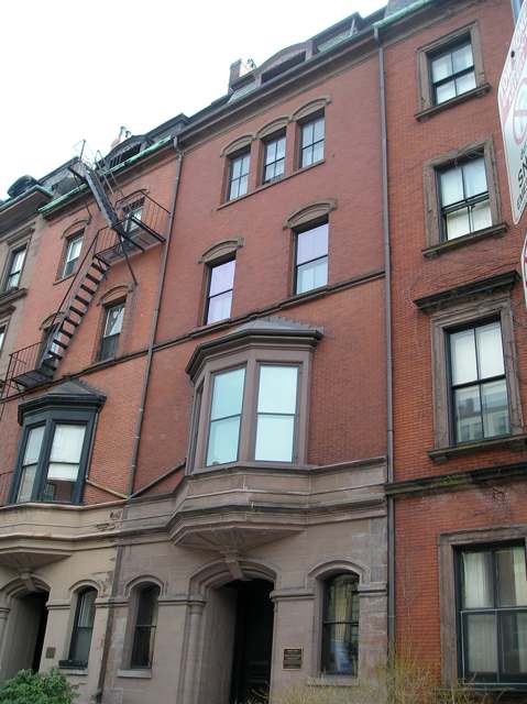
Photo: Adam Lenhardt, CC BY-SA 3.0 · Wikimedia Commons
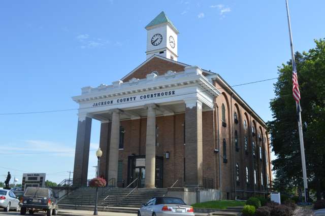
Photo: Nyttend, public domain · Wikimedia Commons
Local history sources: en.wikipedia.org · en.wikipedia.org · en.wikipedia.org · en.wikipedia.org · visitjacksoncountyohio.com · archive.org · ohiohistory.org · commons.wikimedia.org · commons.wikimedia.org
Historic places
1 place in Jackson on the National Register of Historic Places. Press a pin or a name for its whole record.
-
Gibson HouseBuilding · Jackson · listed 1985
- Address
- 187 Main St.
- Where
- Jackson, Jackson County · ZIP 45640
- What it is
- Building
- Listed on the National Register
- 1985
- NRIS reference number
- 85003045
- Coordinates
- 39.05283, -82.63801
National Register file (NPS) ↗ Search Wikipedia ↗ Street map and directions ↗ On the Cracked Buckeye map
Source: National Park Service, National Register of Historic Places point file. The listing year is shown where NPS's certification date agrees with the listing's reference number. Listing recognizes significance; it does not restrict a private owner.
Water
Hammertown Lake (primary); Jisco Lake (backup) The water here
- Jackson, City Of94% of residentsJisco Lake + Hammertown Lake (Jackson City Reservoir)
- Wellston City6% of residentsLake Rupert + Lake Alma (Little Raccoon Creek reservoirs)
Hospitals, fire stations and more
Inside Jackson's boundary: 1 hospital, 2 health centers, 1 fire or EMS station, 1 high-hazard dam, 5 public schools, 2 poor-rated bridges, 1 library, 3 museums, 2 police stations, 6 Toxics Release Inventory facilities and 9 spill cases. Press a pin or a name for its whole record and its source.
Hospitals (1)
-
Holzer Medical Center - JacksonCritical access hospital · Jackson
- What it is
- Critical access hospital
- Address
- 500 Burlington Road, Jackson, OH 45640
- County
- Jackson County
- Beds
- 25
- Helipad
- Yes
- Ownership
- Non-profit
- Medicare overall rating
- 3 of 5 stars
- Emergency department (Medicare)
- Yes
- Medicare reports it as
- Holzer Medical Center Jackson
- Phone
- (740) 395-8500
- Medicare ID
- 361320
Medicare Care Compare ↗ Hospital's website ↗ Where HIFLD got this record ↗ HIFLD hospitals (source) ↗ Street map and directions ↗
Source: HIFLD hospitals inventory via FEMA (closed hospitals it still lists left out, hospitals opened since added), with Medicare Care Compare ratings matched by name and address.
Community health centers (2)
-
Hopewell Health Centers - Jackson BurlingtonHealth center · Jackson
- Run by
- a federally qualified health center
- Setting
- Clinic
- City
- Jackson
- Coordinates
- 39.03231, -82.64076
Find a Health Center (HRSA) ↗ HRSA data (source) ↗ Street map and directions ↗
-
Hopewell Health Centers - Jackson McCartyHealth center · Jackson
- Run by
- a federally qualified health center
- Setting
- Clinic
- City
- Jackson
- Coordinates
- 39.03238, -82.61990
Find a Health Center (HRSA) ↗ HRSA data (source) ↗ Street map and directions ↗
Source: HRSA health center service delivery sites, active, September 2026 (school-based sites left out). Health centers see patients whether or not they have insurance, with fees on a sliding scale.
Fire and EMS stations (1)
-
Jackson Fire DepartmentJackson
- Address
- 152 Pearl Street, Jackson, OH 45640
- Coordinates
- 39.05286, -82.63985
USGS National Map structures (source) ↗ Street map and directions ↗
Source: USGS National Map structures (most Ohio records last updated 2019 to 2022), checked against the Columbus and Cleveland station lists. The department that answers a call is set by jurisdiction and mutual aid, not by distance.
High-hazard dams (1)
-
Hammertown Lake Dam PoorTributary To Buckeye Creek · condition: poor
- Hazard class
- High: a failure would probably cost a life
- Condition
- Poor (assessed 12/15/2023)
- River or stream
- Tributary To Buckeye Creek
- Purpose
- Water Supply;Recreation
- Type
- Earth
- Height
- 60 ft
- Storage
- 6,239 acre-feet
- Completed
- 1954
- Owner type
- Local Government
- County
- Jackson County
- Nearest town (NID)
- Sharon
- Last inspection
- 11/03/2022
- Emergency action plan
- Yes
- NID ID
- OH00507
National Inventory of Dams record ↗ National Inventory of Dams (source) ↗ Street map and directions ↗
Source: U.S. Army Corps of Engineers National Inventory of Dams, August 2026. "High hazard" rates what a failure would cost downstream, not how likely one is; the condition is the state's assessment.
Public schools (5)
-
Jackson High School3 of 5 stars · Jackson
- Address
- 500 Vaughn St, Jackson, OH 45640
- School district
- Jackson City School District
- Kind (NCES)
- Regular School
- Students, 2023-24
- 605
- Teachers (full-time equivalent)
- 31
- Report card, 2025-26
- 3 of 5 stars
- Performance index
- 72.5%
- Four-year graduation rate
- 97.5%
- Ohio building IRN
- 017756
- NCES school ID
- 390441501075
NCES school record ↗ Ohio School Report Card ↗ Street map and directions ↗
-
Jackson Middle School2.5 of 5 stars · Jackson
- Address
- 21 Tropic St, Jackson, OH 45640
- School district
- Jackson City School District
- Kind (NCES)
- Regular School
- Students, 2023-24
- 524
- Teachers (full-time equivalent)
- 30.38
- Report card, 2025-26
- 2.5 of 5 stars
- Performance index
- 75.5%
- Ohio building IRN
- 020453
- NCES school ID
- 390441501077
NCES school record ↗ Ohio School Report Card ↗ Street map and directions ↗
-
Jackson Northview Elementary School3 of 5 stars · Jackson
- Address
- 11507 Chillicothe Pike, Jackson, OH 45640
- School district
- Jackson City School District
- Kind (NCES)
- Regular School
- Students, 2023-24
- 398
- Teachers (full-time equivalent)
- 27
- Report card, 2025-26
- 3 of 5 stars
- Performance index
- 80.7%
- Ohio building IRN
- 009160
- NCES school ID
- 390441505400
NCES school record ↗ Ohio School Report Card ↗ Street map and directions ↗
-
Jackson Southview Elementary School4.5 of 5 stars · Jackson
- Address
- 13842 State Route 93, Jackson, OH 45640
- School district
- Jackson City School District
- Kind (NCES)
- Regular School
- Students, 2023-24
- 368
- Teachers (full-time equivalent)
- 26
- Report card, 2025-26
- 4.5 of 5 stars
- Performance index
- 81.7%
- Ohio building IRN
- 152298
- NCES school ID
- 390441504535
NCES school record ↗ Ohio School Report Card ↗ Street map and directions ↗
-
Jackson Westview Elementary School5 of 5 stars · Jackson
- Address
- 16349 Beaver Pike, Jackson, OH 45640
- School district
- Jackson City School District
- Kind (NCES)
- Regular School
- Students, 2023-24
- 405
- Teachers (full-time equivalent)
- 24
- Report card, 2025-26
- 5 of 5 stars
- Performance index
- 88.8%
- Ohio building IRN
- 000429
- NCES school ID
- 390441505279
NCES school record ↗ Ohio School Report Card ↗ Street map and directions ↗
Source: NCES EDGE public school locations 2024-25 and Common Core of Data 2023-24 (type, students, teachers); Ohio School Report Cards 2025-26 (Department of Education and Workforce), matched by name within the district.
Bridges rated poor (2)
-
Burlington Road over Mcdowells RunPoor · built 1935
- Condition
- Poor: a deck, superstructure, substructure or culvert rated 4 or below on the 0 to 9 scale
- What it is
- Bridge
- Built
- 1935
- Length
- 8 ft
- Owner
- City
- Vehicles a day
- 2,108
- Coordinates
- 39.04589, -82.63663
National Bridge Inventory (source) ↗ Street map and directions ↗
-
Logan Street over Horse CreekPoor · built 1935
- Condition
- Poor: a deck, superstructure, substructure or culvert rated 4 or below on the 0 to 9 scale
- What it is
- Bridge
- Built
- 1935
- Length
- 12 ft
- Owner
- City
- Vehicles a day
- 478
- Coordinates
- 39.05984, -82.63651
National Bridge Inventory (source) ↗ Street map and directions ↗
Source: FHWA National Bridge Inventory 2025. "Poor" means one major part rated 4 or below on the 0 to 9 scale; it calls for repair, not closing, unless the state posts or closes the bridge.
Public libraries (1)
-
Jackson City LibraryCentral library · Jackson
- Address
- 21 Broadway St., Jackson, OH 45640
- What it is
- Central library
- Library system
- Jackson City Library
- Open
- 2,236 hours a year, 52 weeks
- Building
- 10,269 sq ft
- System's visits, FY2024
- 40,924
- System's loans, FY2024
- 71,279
- People the system serves
- 16,053
- Phone
- (740) 286-4111
IMLS Public Libraries Survey (source) ↗ Street map and directions ↗
Source: IMLS Public Libraries Survey FY2024 (outlets and their systems). Any Ohio resident can get a free card at any Ohio public library.
Museums, historical societies, gardens and zoos (3)
-
Jackson County Veterans OrganizationHistorical society · Jackson
- What it is
- Historical society
- City
- Jackson
- Coordinates
- 39.04719, -82.65255
Search Wikipedia ↗ IMLS Museum Data Files (source) ↗ Street map and directions ↗
The museum list is IMLS's 2018 file; a museum may have closed or moved since.
-
Jackson Historical SocietyHistorical society · Jackson
- What it is
- Historical society
- City
- Jackson
- Coordinates
- 39.04531, -82.65187
Search Wikipedia ↗ IMLS Museum Data Files (source) ↗ Street map and directions ↗
The museum list is IMLS's 2018 file; a museum may have closed or moved since.
-
Lillian Jones MuseumMuseum · Jackson
- What it is
- Museum
- City
- Jackson
- Coordinates
- 39.05396, -82.63282
Search Wikipedia ↗ IMLS Museum Data Files (source) ↗ Street map and directions ↗
The museum list is IMLS's 2018 file; a museum may have closed or moved since.
Source: IMLS Museum Data Files, 2018.
Police stations (2)
-
Jackson County Sheriff's OfficeJackson
- Address
- 350 Portsmouth Street, Jackson, OH 45640
- Coordinates
- 39.05331, -82.63710
USGS National Map structures (source) ↗ Street map and directions ↗
-
Jackson Police DepartmentJackson
- Address
- 199 Portsmouth Street, Jackson, OH 45640
- Coordinates
- 39.05143, -82.63913
USGS National Map structures (source) ↗ Street map and directions ↗
Source: USGS National Map structures, police stations, corrected and completed by hand (September 2026). The department that answers a call is set by jurisdiction, not by distance.
Facilities reporting toxic releases (6)
-
Bellisio FoodsToxics Release Inventory · Jackson
- Address
- 100 E Broadway St, Jackson, OH 45640
- County
- Jackson County
- Status
- Reports to the Toxics Release Inventory (active)
- EPA program ID
- 45640JNSXX100EB
- EPA registry ID
- 110000537321
EPA facility record ↗ EPA Facility Registry Service (source) ↗ Street map and directions ↗
-
Elemetal Refining LlcToxics Release Inventory · Jackson
- Address
- 16064 Beaver Pike, Jackson, OH 45640
- County
- Jackson County
- Status
- Reports to the Toxics Release Inventory (active)
- EPA program ID
- 45640PMLLC1664B
- EPA registry ID
- 110004624853
EPA facility record ↗ EPA Facility Registry Service (source) ↗ Street map and directions ↗
-
Jm Moss Dba My Gold TradeToxics Release Inventory · Jackson
- Address
- 45 E South St, Jackson, OH 45640
- County
- Jackson County
- Status
- Reports to the Toxics Release Inventory
- EPA program ID
- TRI_OFFSITE_1094
- EPA registry ID
- 110070691658
EPA facility record ↗ EPA Facility Registry Service (source) ↗ Street map and directions ↗
-
Lykins- (Jackson Bulk Plant #0648)Toxics Release Inventory · Jackson
- Address
- 107 Athens St., Jackson, OH 45640
- County
- Jackson County
- Status
- Reports to the Toxics Release Inventory
- EPA program ID
- 4564WLYKNS17ATH
- EPA registry ID
- 110000814334
EPA facility record ↗ EPA Facility Registry Service (source) ↗ Street map and directions ↗
-
Ohio Precious Metals LlcToxics Release Inventory · Jackson
- Address
- 305 Water St, Jackson, OH 45640
- County
- Jackson County
- Status
- Reports to the Toxics Release Inventory (active)
- EPA program ID
- 45640HPRCS305WA
- EPA registry ID
- 110000395215
EPA facility record ↗ EPA Facility Registry Service (source) ↗ Street map and directions ↗
-
Osco Industries Inc - Jackson DivToxics Release Inventory · Jackson
- Address
- 165 Athens St, Jackson, OH 45640
- County
- Jackson County
- Status
- Reports to the Toxics Release Inventory (open)
- EPA program ID
- 45640SCNDSATHEN
- EPA registry ID
- 110000605471
EPA facility record ↗ EPA Facility Registry Service (source) ↗ Street map and directions ↗
Source: EPA Facility Registry Service, Toxics Release Inventory reporters. Reporting a release is required of large users of listed chemicals; it is not by itself a violation.
Spills reported since 2021 (9)
-
Ethylene Glycol (C2H6O2) Reached water2025-12-10 · Jackson
- Reported
- 2025-12-10
- What spilled
- Ethylene Glycol (C2H6O2)
- Reached a waterway
- 99 - Unnamed
- Where
- Jackson, Jackson County
- Ohio EPA district office
- SEDO
- Ohio EPA case number
- 2512EPA0001977
Ohio EPA spill reports (source) ↗ Street map and directions ↗
-
Sewage Human Reached water2025-09-22 · Jackson
- Reported
- 2025-09-22
- What spilled
- Sewage Human
- Reached a waterway
- 99 - Unnamed
- Where
- Jackson, Jackson County
- Ohio EPA district office
- SEDO
- Ohio EPA case number
- 2509EPA0001576
Ohio EPA spill reports (source) ↗ Street map and directions ↗
-
Oil Transformer Non Pcb2024-08-29 · Liberty Twp
- Reported
- 2024-08-29
- What spilled
- Oil Transformer Non Pcb
- Largest amount reported
- 56 gallons
- Where
- Liberty Twp, Jackson County
- Ohio EPA district office
- SEDO
- Ohio EPA case number
- 2408EPA0001483
Ohio EPA spill reports (source) ↗ Street map and directions ↗
-
Sewage Human2024-07-16 · Jackson
- Reported
- 2024-07-16
- What spilled
- Sewage Human
- Where
- Jackson, Jackson County
- Ohio EPA district office
- SEDO
- Ohio EPA case number
- 2407EPA0001208
Ohio EPA spill reports (source) ↗ Street map and directions ↗
-
Sewage Human2024-07-03 · Jackson
- Reported
- 2024-07-03
- What spilled
- Sewage Human
- Where
- Jackson, Jackson County
- Ohio EPA district office
- SEDO
- Ohio EPA case number
- 2407EPA0001114
Ohio EPA spill reports (source) ↗ Street map and directions ↗
-
Natural Gas2024-01-26 · Jackson
- Reported
- 2024-01-26
- What spilled
- Natural Gas
- Where
- Jackson, Jackson County
- Ohio EPA district office
- SEDO
- Ohio EPA case number
- 2401EPA0000133
Ohio EPA spill reports (source) ↗ Street map and directions ↗
-
Oil Mineral / Baby Oil / White Oil / Liquid Paraffin2023-05-10 · Jackson
- Reported
- 2023-05-10
- What spilled
- Oil Mineral / Baby Oil / White Oil / Liquid Paraffin
- Largest amount reported
- 20 gallons
- Where
- Jackson, Jackson County
- Ohio EPA district office
- SEDO
- Ohio EPA case number
- 2305EPA0000761
Ohio EPA spill reports (source) ↗ Street map and directions ↗
-
Oil Petroleum Not Otherwise Specified (Nos)2026-06-29 · Jackson
- Reported
- 2026-06-29
- What spilled
- Oil Petroleum Not Otherwise Specified (Nos); Antifreeze Vehicle Cooling
- Where
- Jackson, Jackson County
- Ohio EPA district office
- SEDO
- Ohio EPA case number
- 2606EPA0001158
Ohio EPA spill reports (source) ↗ Street map and directions ↗
-
Anhydrous Ammonia (Nh3)2026-05-31 · Jackson
- Reported
- 2026-05-31
- What spilled
- Anhydrous Ammonia (Nh3)
- Where
- Jackson, Jackson County
- Ohio EPA district office
- SEDO
- Ohio EPA case number
- 2605EPA0000947
Ohio EPA spill reports (source) ↗ Street map and directions ↗
Source: Ohio EPA emergency response spill reports, 2021 to September 2026, one point per case where Ohio EPA placed it. A report is what the caller or responder recorded; amounts are often blank or estimated.
Its ZIP codes
Each ZIP code that touches Jackson, with the share of its residents who live here and the same headline figures as the ZIP page.
| ZIP | Share | Water | Radon | Home value | Schools | Flood |
|---|---|---|---|---|---|---|
| 45640 Jackson | 39% | Hammertown Lake (primary); Jisco Lake (backup) | 2.4 pCi/L average radon | Median year built 1971 | Jackson City · 3.5 stars overall | 4.3% of residents in the 1% floodplain |
Local government
Who holds office in Jackson, how its elections and ballot issues came out, and the state auditor's record.
Money issues on the ballot since 2020: 2 of 2 passed.
Ballot issues
| Date | Issue | For | Against | Result |
|---|---|---|---|---|
| 2020-11-03 | Issue: CITY OF JACKSON 1.5% INCOME TAX | 1,482 | 1,228 | Passed (54.69% for), unofficial |
| 2020-11-03 | Issue: CITY OF JACKSON CEMETERY | 1,690 | 991 | Passed (63.04% for), unofficial |
Elections for office
| Date | Office | Candidates and votes |
|---|---|---|
| 2019-05-07 | Member of Council, At Large (REP primary) | MARVA COLBY 369, 45.0%; BRETT FOSTER 451, 55.0% |
| 2019-05-07 | Mayor (REP primary) | ERIC G. BROWN 288, 35.38%; RANDY EVANS 526, 64.62% |
| 2019-05-07 | Auditor (REP primary) | BRETT E. REED 574, 100.0% |
| 2015-05-05 | Ward 4 Council REP (unofficial count) | Brett Foster 94, 59.12%; Marva J. Colby 65, 40.88% |
| 2015-05-05 | Ward 3 Council REP (unofficial count) | Jeff Elliott 44, 100.0% |
| 2015-05-05 | Ward 1 Council REP (unofficial count) | Jon Hensler 68, 100.0% |
| 2015-05-05 | Treasurer REP (unofficial count) | John T. Evans 232, 100.0% |
| 2015-05-05 | President of Council REP (unofficial count) | Eric G. Brown 255, 100.0% |
| 2015-05-05 | Mayor REP (unofficial count) | Douglas A. Reed 194, 100.0% |
| 2015-05-05 | Council At Large REP (number of seats not on file, so winners are not marked) (unofficial count) | Jon L. Ondera 222, 28.68%; George Kitchen 210, 27.13%; Loretta Jones 179, 23.13%; Deborah C. Biggs 163, 21.06% |
| 2015-05-05 | Auditor REP (unofficial count) | Brett E. Reed 272, 100.0% |
Winners in bold. Results from the county board of elections' official canvass unless marked.
Auditor of State record
- Fiscal watch: declared 2002-11-18, released 2005-01-10. source
- Financial Health Indicators (the Auditor of State's 17 measures; critical / cautionary / positive): 2020 0 / 1 / 15; 2021 0 / 3 / 13; 2022 0 / 1 / 15; 2023 0 / 0 / 16; 2024 0 / 0 / 16; 2025 0 / 2 / 13.
- OPERS Examination, 2025, released 2026-05-07
- Financial Audit, 2024, released 2025-09-11
- Financial Audit, 2023, released 2024-10-08
The county
Jackson County: 4 ZIP codes, 16 cities, villages and townships, 31,291 people.
Nearby places
Rain and snow
How much has actually fallen on Jackson, day by day, from 1893 to now. Daily totals, not averages.
- rain, last 30 days
- 0.57 in
- 2026-09-30 to 2026-10-29
- rain so far in 2026
- 39.9 in
- 2.0 in above normal for the date
- snow so far in 2026
- 17.0 in
- a normal year brings 20.4 in
- a normal year
- 44.5 in
- average of 30 years, 1991-2020
| Month | Rain (in) | Snow (in) | Days counted |
|---|---|---|---|
| October 2026 | 0.57 | — | 29 |
| September 2026 | 9.66 | — | 30 |
| August 2026 | 5.25 | — | 31 |
| July 2026 | 4.69 | — | 31 |
| June 2026 | 4.05 | — | 30 |
| May 2026 | 6.61 | — | 31 |
| April 2026 | 1.66 | — | 30 |
| March 2026 | 4.69 | 1.1 | 31 |
| February 2026 | 0.73 | 5.0 | 28 |
| January 2026 | 1.94 | 10.8 | 31 |
| December 2025 | 1.34 | 9.9 | 31 |
| November 2025 | 3.41 | 2.3 | 30 |
| Wettest year | 2011 — 61.3 in |
|---|---|
| Driest year | 1987 — 25.3 in |
| Snowiest year | 1917 — 53.0 in |
| Wettest day on record | 2 March 1997 — 4.76 in |
| Heaviest snowfall in a day | 5 March 1902 — 13.88 in |
| Deepest snow on the ground | 4 February 1907 — 39.02 in |
Mostly estimated. Only 1% of these days come from a gauge standing inside Jackson - the rest are worked out from the nearest gauges around it, so read them as close estimates rather than readings.
48,542 days of records, 1893-01-01 to 2026-10-29. Source: NOAA NCEI GHCN-Daily, 3,240 gauges in and around Ohio. A day is "gauged" when a gauge standing inside the boundary reported it, and the value is the mean of those gauges. Otherwise it is interpolated by inverse distance from every gauge reporting within 50 miles. Nothing is carried forward, back-filled or smoothed. Against NOAA nClimDiv county monthly precipitation over 136,848 complete county-months (checked 2026-10-31): correlation 0.9515, median absolute difference 0.217 in a month. Built 2026-10-31 from the Cracked Buckeye precipitation archive. Snow is the softer number — snowfall is measured by hand with a ruler, no agency publishes a gridded county snowfall series, and blowing snow defeats every observer.
Environmental permits and filings
What Ohio EPA has on file for Jackson: permits, inspections, violations, cleanups and the state loans behind sewer and water work. Every line links to the agency's own document.
- facilities and sites on file
- 58
- those placed on the map inside Jackson
| Program | Facilities and sites |
|---|---|
| Hazardous waste | 16 |
| State sewer loans | 8 |
| Air pollution | 7 |
| Voluntary cleanup | 6 |
| Brownfield | 5 |
| Public drinking water | 4 |
| Wastewater and stormwater discharge | 4 |
| Contaminated-site cleanup | 2 |
| Wetland and stream fill | 2 |
| Sewer and water-line construction | 1 |
| Source-water protection | 1 |
| State water loans | 1 |
| 1 smaller programs |
| Date | Facility or site | What |
|---|---|---|
| JACKSON WWTP | Sewer and water-line construction permit | |
| JACKSON WWTP | Sewer and water-line construction permit | |
| JACKSON WWTP | Sewer and water-line construction permit | |
| JACKSON, CITY OF PWS | Public drinking water violation resolved | |
| W4C MINISTRIES BUILDING | Brownfield assessment | |
| PATTONSVILLE SWITCH LINE EXTENSION PROJECT | Wastewater and stormwater discharge permit | |
| JACKSON, CITY OF PWS | Public drinking water compliance letter | |
| SPEYSIDE BOURBON COOPERAGE INC | Air pollution permit | |
| SOUTHERN OHIO CREMATION SERVICES | Air pollution report | |
| JACKSON, CITY OF PWS | Public drinking water report | |
| GOODYEAR TIRE & RUBBER CO, JACKSON | Voluntary cleanup inspection | |
| OHIO SAND SOLUTIONS LLC | Air pollution report | |
| SPEYSIDE BOURBON COOPERAGE INC | Air pollution permit | |
| JACKSON, CITY OF PWS | Public drinking water letter | |
| CITY OF JACKSON STREAM IMPROVEMENTS PROJECT | Wetland and stream fill permit | |
| W4C MINISTRIES BUILDING | Brownfield assessment | |
| W4C MINISTRIES BUILDING | Brownfield assessment | |
| JACKSON, CITY OF PWS | Public drinking water plan | |
| JACKSON, CITY OF PWS | Public drinking water notice of violation | |
| GOODYEAR TIRE & RUBBER CO, JACKSON | Voluntary cleanup inspection | |
| W4C MINISTRIES BUILDING | Brownfield assessment | |
| GENERAL TIBBETS STREET EXTENSION | Wastewater and stormwater discharge permit | |
| JACKSON, CITY OF PWS | Public drinking water notice of violation | |
| JACKSON, CITY OF PWS | Public drinking water inspection | |
| W4C MINISTRIES BUILDING | Brownfield assessment |
Source: Ohio EPA eDocument portal (edocpub.epa.ohio.gov), indexed 2026-10-14. Facilities are placed on the map from Ohio EPA's own map layers, EPA's Facility Registry, coordinates written in the filings, or a geocoded street address. A permit filed under a private person's name (most are household septic systems) is counted but never named, placed or linked; licenses for individual workers and open-burning notices are left out entirely.
Quick answers
What county is Jackson, Ohio in?
Jackson is a city in Jackson County, Ohio, with 6,195 residents.
When was Jackson, Ohio founded?
Jackson was settled 1795 (salt works; first sustained American settlement); laid out 1817. Founders on record: county organizers, on the site of the Scioto Salt Licks. Source
How did Jackson, Ohio get its name?
Jackson, like Jackson County, was named for Andrew Jackson, a hero of the War of 1812 who was later elected President of the United States. Source
What ZIP code is Jackson, Ohio?
Most of Jackson is in ZIP code 45640.
Where does Jackson, Ohio get its water?
The main water source for Jackson (Jackson, City Of): Hammertown Lake (primary); Jisco Lake (backup).
Cite this page
Cite this page as:
Cracked Buckeye, "Jackson, Jackson County", https://crackedbuckeye.com/place/jackson/, built 2026-10-31, accessed [date].
How to cite · Report a correction · Built 2026-10-31
