Local events in Scioto Township, Jackson County
Nothing is posted for Scioto Township itself yet; here is what is on within 20 miles. All local events in Scioto Township, Jackson County
Know a calendar we should watch? Send the link
Checked October 20; the events page is refreshed daily.
How Scioto Township, Jackson County began
Scioto Township, organized in 1816 as one of Jackson County's original townships, takes its name from the Scioto River system draining the western part of the county. It covers 42.4 square miles and has no incorporated village of its own; the unincorporated crossroads of Petersburg is its best-known place-name. Its landmark is the Johnson Road Covered Bridge, an 1870 Smith-truss bridge over the Brushy Fork of the Little Scioto River, built by Robert W. Smith himself using his 1867 patent. Beyond the bridge and its boundaries, the surviving record of the township's own settlement history is thin.
Incorporated 1816.
Where the name comes from
Named after the Scioto River.
Before the town
No source we found names a village, camp, trail, or mound specific to Scioto Township's own land. At the county level, Jackson County was home to Mingo, Lenape (Delaware), and Shawnee people before removal, and the county holds burial and ceremonial mounds and petroglyphs from earlier prehistoric occupation, but nothing checked here ties any of that specifically to Scioto Township.
Nations recorded here: Mingo (Seneca-Cayuga), Lenape (Delaware), Shawnee.
Timeline
- — Scioto Township is organized as one of Jackson County's original townships, named for the Scioto River.
- — The Jackson County commissioners fix the boundaries of Scioto Township and receive the first road petition, brought by Isaac Baker, for a road from the fork of the creek above Lewis Mercer's on the new county road from Portsmouth to the Scioto salt works toward Hugh Gilliland's on Simms Creek; it is established in 1817, nine and three-quarter miles long.
- — The Johnson Road Covered Bridge is built over the Brushy Fork of the Little Scioto River near Petersburg, using Robert W. Smith's 1867 patented truss design.
- — The Johnson Road Covered Bridge is listed on the National Register of Historic Places, on August 23.
- — The census counts 1,949 residents in Scioto Township.
Stories
A Smith truss on the Brushy Fork
Robert W. Smith patented a truss design for wooden bridges in 1867, and it caught on fast in southern Ohio: nearly every covered bridge Jackson County built in the following decades used it. The Johnson Road Covered Bridge, raised over the Brushy Fork of the Little Scioto River near Petersburg in Scioto Township around 1870, was one of them. Ohio's covered bridges fell one by one over the following century, to floods, fire, neglect, and the simple math of replacing wood with steel and concrete. It was added to the National Register of Historic Places on August 23, 1984.
Photographs
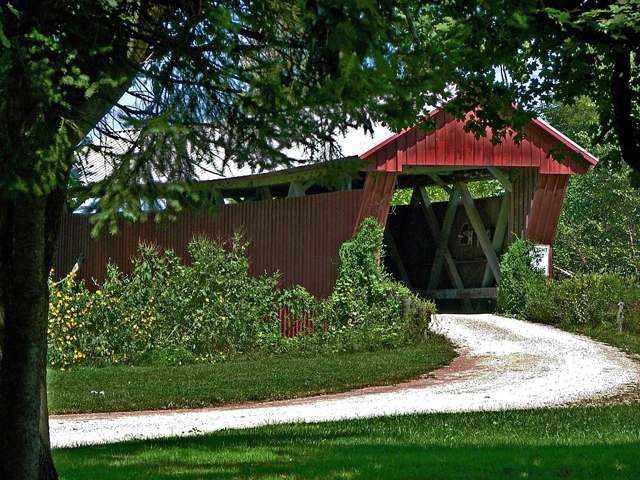
Photo: dok1 (Flickr user), via Wikimedia Commons, CC BY 2.0 · Wikimedia Commons
Local history sources: en.wikipedia.org · en.wikipedia.org · en.wikipedia.org · en.wikipedia.org · ahgp.org · en.wikipedia.org · archive.org
Historic places
2 places in Scioto Township, Jackson County on the National Register of Historic Places. Press a pin or a name for its whole record.
-
Johnson Road Covered BridgeStructure · Petersburg · listed 1984
- Address
- Johnson Rd.
- Where
- Petersburg, Jackson County · ZIP 45640
- What it is
- Structure
- Listed on the National Register
- 1984
- NRIS reference number
- 84003749
- Coordinates
- 38.95873, -82.78760
National Register file (NPS) ↗ Search Wikipedia ↗ Street map and directions ↗ On the Cracked Buckeye map
-
Scioto Grange No. 1234Building · Jackson · listed 2005
- Address
- 255 Cove Rd.
- Where
- Jackson, Jackson County · ZIP 45640
- What it is
- Building
- Listed on the National Register
- 2005
- NRIS reference number
- 05000030
- Coordinates
- 39.01361, -82.74762
National Register file (NPS) ↗ Search Wikipedia ↗ Street map and directions ↗ On the Cracked Buckeye map
Source: National Park Service, National Register of Historic Places point file. The listing year is shown where NPS's certification date agrees with the listing's reference number. Listing recognizes significance; it does not restrict a private owner.
Water
Hammertown Lake (primary); Jisco Lake (backup) The water here
- Jackson, City Of88% of residentsJisco Lake + Hammertown Lake (Jackson City Reservoir)
- Wellston City5% of residentsLake Rupert + Lake Alma (Little Raccoon Creek reservoirs)
- Beaver5% of residentsGroundwater wells (2 wells)
- Oak Hill, Village Of1% of residentsPurchased: Scioto Co. Regional Water Dist. #1 (Teays Valley Aquifer)
Hospitals, fire stations and more
Inside Scioto Township, Jackson County's boundary: 1 fire or EMS station and 2 poor-rated bridges. Press a pin or a name for its whole record and its source.
Fire and EMS stations (1)
-
Scioto Township Volunteer Fire DepartmentJackson
- Address
- 4701 State Route 776, Jackson, OH 45640
- Coordinates
- 38.99023, -82.74562
USGS National Map structures (source) ↗ Street map and directions ↗
Source: USGS National Map structures (most Ohio records last updated 2019 to 2022), checked against the Columbus and Cleveland station lists. The department that answers a call is set by jurisdiction and mutual aid, not by distance.
Bridges rated poor (2)
-
Beaver Pike over Little Scioto RivPoor · built 1935
- Condition
- Poor: a deck, superstructure, substructure or culvert rated 4 or below on the 0 to 9 scale
- What it is
- Bridge
- Built
- 1935
- Length
- 15 ft
- Owner
- County
- Vehicles a day
- 3,341
- Coordinates
- 39.02767, -82.78684
National Bridge Inventory (source) ↗ Street map and directions ↗
-
Bucklick Rd over Sugarcamp CrPoor · built 1901
- Condition
- Poor: a deck, superstructure, substructure or culvert rated 4 or below on the 0 to 9 scale
- What it is
- Bridge
- Built
- 1901
- Length
- 16 ft
- Owner
- County
- Vehicles a day
- 45
- Coordinates
- 38.94828, -82.73886
National Bridge Inventory (source) ↗ Street map and directions ↗
Source: FHWA National Bridge Inventory 2025. "Poor" means one major part rated 4 or below on the 0 to 9 scale; it calls for repair, not closing, unless the state posts or closes the bridge.
Its ZIP codes
Each ZIP code that touches Scioto Township, Jackson County, with the share of its residents who live here and the same headline figures as the ZIP page.
| ZIP | Share | Water | Radon | Home value | Schools | Flood |
|---|---|---|---|---|---|---|
| 45640 Jackson | 10% | Hammertown Lake (primary); Jisco Lake (backup) | 2.4 pCi/L average radon | Median year built 1971 | Jackson City · 3.5 stars overall | 4.3% of residents in the 1% floodplain |
| 45613 Marion Township and Beaver | 9% | Mostly private wells | 3.5 pCi/L average radon | Appraisal records without year built | Eastern Local · 3 stars overall | 1.9% of residents in the 1% floodplain |
| 45656 Jefferson Township and Oak Hill | 1% | Mostly private wells | 1.4 pCi/L average radon | Median year built 1972 | Oak Hill Union Local · 2.5 stars overall | 1.4% of residents in the 1% floodplain |
Local government
Who holds office in Scioto Township, Jackson County, how its elections and ballot issues came out, and the state auditor's record.
Elections for office
| Date | Office | Candidates and votes |
|---|---|---|
| 2017-11-07 | Township Trustee | Charles Durham 182, 48.66%; James S. Leonard 192, 51.34% |
Winners in bold. Results from the county board of elections' official canvass unless marked.
Auditor of State record
- No fiscal caution, watch or emergency on the Auditor of State's lists.
- Financial Audit, 2020 to 2021, released 2025-07-08
The county
Jackson County: 4 ZIP codes, 16 cities, villages and townships, 31,291 people.
Nearby places
Quick answers
What county is Scioto Township, Ohio in?
Scioto Township, Jackson County is a township in Jackson County, Ohio, with 1,949 residents.
When was Scioto Township, Ohio founded?
Scioto Township, Jackson County was incorporated 1816. Source
How did Scioto Township, Ohio get its name?
Named after the Scioto River. Source
What ZIP code is Scioto Township, Ohio?
Scioto Township, Jackson County is served by ZIP codes 45640 and 45613; 45640 holds the largest share of its residents.
Where does Scioto Township, Ohio get its water?
The main water source for Scioto Township, Jackson County (Jackson, City Of): Hammertown Lake (primary); Jisco Lake (backup).
Cite this page
Cite this page as:
Cracked Buckeye, "Scioto Township, Jackson County", https://crackedbuckeye.com/place/scioto-township-jackson-county/, built 2026-10-31, accessed [date].
How to cite · Report a correction · Built 2026-10-31
