Local events in Hanover Township, Columbiana County
Nothing is posted for Hanover Township itself yet; here is what is on within 10 miles. All local events in Hanover Township, Columbiana County
Know a calendar we should watch? Send the link
Checked October 20; the events page is refreshed daily.
How Hanover Township, Columbiana County began
Hanover Township was organized in 1806 in western Columbiana County and holds the village of Hanoverton, founded in 1813 by Quaker abolitionist James Craig, which boomed as a stop on the Sandy and Beaver Canal in the 1830s -- reaching roughly 2,000 residents before the 1852 completion of the Cleveland and Pittsburgh Railroad made the canal unprofitable and the town's growth stalled. Hanoverton's well-preserved canal-era brick buildings, including the 1837 Spread Eagle Tavern (a stop for modern-day political figures as much as travelers), earned the village's 23-acre core a National Register historic district in 1977. Local tradition also credits Hanoverton buildings, including a tunnel linking the Spread Eagle Tavern and the merchant George Sloan's 'Brick Row' to his brother-in-law's house, with Underground Railroad use. Northwest of Hanoverton on State Route 172, the 1832 Hostetter Inn survives as an unusually unaltered example of the township's early commercial architecture.
Settled 1806, platted 1813 (Hanoverton), incorporated 1836 (Hanoverton village), by James Craig (Hanoverton); Columbiana County commissioners (township).
Where the name comes from
No source we reviewed documents the specific reasoning behind Hanover Township's or Hanoverton's name beyond the common practice of naming Ohio towns for German and English namesakes (Hanover, Germany/England) in this period; we do not assert an unconfirmed origin.
Before the town
No source we reviewed names a specific Native American village, camp or burial site within Hanover Township's present boundaries. The township lies within the region ceded under the 1785 Treaty of Fort McIntosh and confirmed by the 1795 Treaty of Greenville. No township-specific site or encounter was found in the sources checked.
Timeline
- — Hanover Township is organized in western Columbiana County.
- — Quaker abolitionist James Craig founds Hanoverton.
- — The Sandy and Beaver Canal reaches Hanoverton, driving rapid growth toward a peak of about 2,000 residents.
- — The Hostetter family builds the two-story brick inn on the road northwest of Hanoverton that becomes the Hostetter Inn.
- — Hanoverton incorporates as a village.
- — The Spread Eagle Tavern opens in Hanoverton.
- — Completion of the Cleveland and Pittsburgh Railroad ends the Sandy and Beaver Canal's profitability, and Hanoverton's growth stalls.
- — A 23-acre Hanoverton Canal Town Historic District, preserving largely unchanged canal-era architecture, is listed on the National Register of Historic Places.
- — The Hostetter Inn, northwest of Lisbon on State Route 172, is separately listed on the National Register of Historic Places.
Stories
A canal town frozen at its peak
James Craig, a Quaker abolitionist, founded Hanoverton in 1813, but it was the Sandy and Beaver Canal's arrival in the 1830s that transformed it from a small crossroads into a genuine boomtown, briefly reaching about 2,000 residents as goods and travelers moved through on the water. That boom collapsed almost as fast as it had come: the canal was never reliably profitable, and the 1852 completion of the Cleveland and Pittsburgh Railroad finished it off, leaving Hanoverton's growth stalled at essentially its canal-era size. The upside of that arrested development showed up more than a century later -- because the town never grew enough to tear down and rebuild its early brick storefronts and inns, a 23-acre core of largely unaltered canal-era architecture survived intact long enough to be listed as a National Register historic district in 1977, and the 1837 Spread Eagle Tavern still operates as a restaurant today, one that has hosted a string of modern political figures from Dan Quayle to JD Vance.
A tunnel under Brick Row
Local history in Hanoverton holds that the Underground Railroad ran, quite literally, underground here: an underground passage is said to have connected merchant George Sloan's building known as 'Brick Row' with the home of his brother-in-law, Dr. James Robertson, where a secret room sheltered people escaping slavery, and the Spread Eagle Tavern is likewise said to have had a tunnel feeding into the same network. Whether every physical detail of the tunnels survives verification, the tradition sits comfortably alongside the documented antislavery activity of nearby Salem and Columbiana, part of a broader pattern across Quaker-settled Columbiana County of hidden rooms, sympathetic households and canal-town geography used to move people north.
Photographs
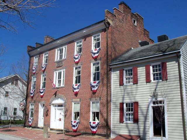
Photo: Roseohioresident (Wikimedia Commons), CC BY-SA 4.0 · Wikimedia Commons
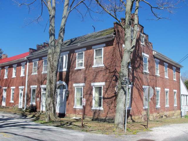
Photo: Roseohioresident (Wikimedia Commons), CC BY-SA 4.0 · Wikimedia Commons
Local history sources: en.wikipedia.org · en.wikipedia.org · en.wikipedia.org · commons.wikimedia.org · commons.wikimedia.org
Historic places
1 place in Hanover Township, Columbiana County on the National Register of Historic Places. Press a pin or a name for its whole record.
-
Hostetter InnBuilding · Lisbon · listed 1980
- Address
- NW of Lisbon, 32901 OH 172
- Where
- Lisbon, Columbiana County · ZIP 44432
- What it is
- Building
- Listed on the National Register
- 1980
- NRIS reference number
- 80002965
- Coordinates
- 40.79293, -80.88045
National Register file (NPS) ↗ Search Wikipedia ↗ Street map and directions ↗ On the Cracked Buckeye map
Source: National Park Service, National Register of Historic Places point file. The listing year is shown where NPS's certification date agrees with the listing's reference number. Listing recognizes significance; it does not restrict a private owner.
Water
Mostly private wells The water here
- Lisbon Village98% of residentsGroundwater wells (6 wells)
- Columbiana County-county Home Rd2% of residentsEast Cold Run Reservoir & Spring Valley Reservoir (Cold Run Creek)
Hospitals, fire stations and more
Inside Hanover Township, Columbiana County's boundary: 1 fire or EMS station, 1 high-hazard dam, 2 public schools, 1 museum, 17 shale and injection wells, 1 Superfund site, 2 Toxics Release Inventory facilities and 8 spill cases. Press a pin or a name for its whole record and its source.
Fire and EMS stations (1)
-
Hanover Township Volunteer Fire Department Guilford Lake StationLisbon
- Address
- 33555 State Highway 172, Lisbon, OH 44432
- Coordinates
- 40.79146, -80.86656
USGS National Map structures (source) ↗ Street map and directions ↗
Source: USGS National Map structures (most Ohio records last updated 2019 to 2022), checked against the Columbus and Cleveland station lists. The department that answers a call is set by jurisdiction and mutual aid, not by distance.
High-hazard dams (1)
-
Guilford Lake Dam PoorWest Fork Little Beaver Creek · condition: poor
- Hazard class
- High: a failure would probably cost a life
- Condition
- Poor (assessed 06/27/2019)
- River or stream
- West Fork Little Beaver Creek
- Purpose
- Recreation
- Type
- Earth
- Height
- 35 ft
- Storage
- 5,650 acre-feet
- Completed
- 1933
- Owner type
- State
- County
- Columbiana County
- Nearest town (NID)
- Guilford
- Last inspection
- 05/09/2024
- Emergency action plan
- Yes
- NID ID
- OH00636
National Inventory of Dams record ↗ National Inventory of Dams (source) ↗ Street map and directions ↗
Source: U.S. Army Corps of Engineers National Inventory of Dams, August 2026. "High hazard" rates what a failure would cost downstream, not how likely one is; the condition is the state's assessment.
Public schools (2)
-
United Elementary School3.5 of 5 stars · Hanoverton
- Address
- 8143 State Route 9, Hanoverton, OH 44423
- School district
- United Local School District
- Kind (NCES)
- Regular School
- Students, 2023-24
- 441
- Teachers (full-time equivalent)
- 29
- Report card, 2025-26
- 3.5 of 5 stars
- Performance index
- 79.2%
- Ohio building IRN
- 037903
- NCES school ID
- 390464502561
NCES school record ↗ Ohio School Report Card ↗ Street map and directions ↗
-
United High School4 of 5 stars · Hanoverton
- Address
- 8143 State Route 9, Hanoverton, OH 44423
- School district
- United Local School District
- Kind (NCES)
- Regular School
- Students, 2023-24
- 553
- Teachers (full-time equivalent)
- 36.5
- Report card, 2025-26
- 4 of 5 stars
- Performance index
- 76.2%
- Four-year graduation rate
- 97.1%
- Ohio building IRN
- 037911
- NCES school ID
- 390464502562
NCES school record ↗ Ohio School Report Card ↗ Street map and directions ↗
Source: NCES EDGE public school locations 2024-25 and Common Core of Data 2023-24 (type, students, teachers); Ohio School Report Cards 2025-26 (Department of Education and Workforce), matched by name within the district.
Museums, historical societies, gardens and zoos (1)
-
Hanover Township Historical SocietyHistorical society · Kensington
- What it is
- Historical society
- City
- Kensington
- Coordinates
- 40.73590, -80.95458
Search Wikipedia ↗ IMLS Museum Data Files (source) ↗ Street map and directions ↗
The museum list is IMLS's 2018 file; a museum may have closed or moved since.
Source: IMLS Museum Data Files, 2018.
Shale and injection wells (17)
-
Altenhof 10-15-4 3HUtica shale well
- What it is
- Utica shale well
- Drilled sideways
- Yes
- Operator
- Eog Ohio, Llc
- County
- Columbiana County
- API well number
- 34029218040100
- Coordinates
- 40.79205, -80.90997
ODNR oil and gas wells (source) ↗ Street map and directions ↗
The point is the surface well head (the pad); a horizontal well runs a mile or more underground from it.
-
D & B Kibler 29-15-4 1HUtica shale well
- What it is
- Utica shale well
- Drilled sideways
- Yes
- Operator
- Eog Ohio, Llc
- County
- Columbiana County
- API well number
- 34029218470000
- Coordinates
- 40.74544, -80.94041
ODNR oil and gas wells (source) ↗ Street map and directions ↗
The point is the surface well head (the pad); a horizontal well runs a mile or more underground from it.
-
Frank Zehentbauer 26-15-4 10HUtica shale well
- What it is
- Utica shale well
- Drilled sideways
- Yes
- Operator
- Eog Ohio, Llc
- County
- Columbiana County
- API well number
- 34029218240000
- Coordinates
- 40.74716, -80.88738
ODNR oil and gas wells (source) ↗ Street map and directions ↗
The point is the surface well head (the pad); a horizontal well runs a mile or more underground from it.
-
Frank Zehentbauer 26-15-4 3HUtica shale well
- What it is
- Utica shale well
- Drilled sideways
- Yes
- Operator
- Eog Ohio, Llc
- County
- Columbiana County
- API well number
- 34029218180000
- Coordinates
- 40.74718, -80.88748
ODNR oil and gas wells (source) ↗ Street map and directions ↗
The point is the surface well head (the pad); a horizontal well runs a mile or more underground from it.
-
Hanover Farms 34-15-4 3HUtica shale well
- What it is
- Utica shale well
- Drilled sideways
- Yes
- Operator
- Eog Ohio, Llc
- County
- Columbiana County
- API well number
- 34029217120000
- Coordinates
- 40.73236, -80.90419
ODNR oil and gas wells (source) ↗ Street map and directions ↗
The point is the surface well head (the pad); a horizontal well runs a mile or more underground from it.
-
Hanover Farms 34-15-4 6HUtica shale well
- What it is
- Utica shale well
- Drilled sideways
- Yes
- Operator
- Eog Ohio, Llc
- County
- Columbiana County
- API well number
- 34029217200000
- Coordinates
- 40.73225, -80.90417
ODNR oil and gas wells (source) ↗ Street map and directions ↗
The point is the surface well head (the pad); a horizontal well runs a mile or more underground from it.
-
Henceroth 36-15-4 3HUtica shale well
- What it is
- Utica shale well
- Drilled sideways
- Yes
- Operator
- Eog Ohio, Llc
- County
- Columbiana County
- API well number
- 34029217080000
- Coordinates
- 40.73839, -80.86825
ODNR oil and gas wells (source) ↗ Street map and directions ↗
The point is the surface well head (the pad); a horizontal well runs a mile or more underground from it.
-
Jan Paul Farms 17-15-4 8HUtica shale well
- What it is
- Utica shale well
- Drilled sideways
- Yes
- Operator
- Eog Ohio, Llc
- County
- Columbiana County
- API well number
- 34029217340000
- Coordinates
- 40.77976, -80.94008
ODNR oil and gas wells (source) ↗ Street map and directions ↗
The point is the surface well head (the pad); a horizontal well runs a mile or more underground from it.
-
Judy Brown 27-15-4 3HUtica shale well
- What it is
- Utica shale well
- Drilled sideways
- Yes
- Operator
- Eog Ohio, Llc
- County
- Columbiana County
- API well number
- 34029218050000
- Coordinates
- 40.74901, -80.90221
ODNR oil and gas wells (source) ↗ Street map and directions ↗
The point is the surface well head (the pad); a horizontal well runs a mile or more underground from it.
-
Judy Brown 27-15-4 6HUtica shale well
- What it is
- Utica shale well
- Drilled sideways
- Yes
- Operator
- Eog Ohio, Llc
- County
- Columbiana County
- API well number
- 34029218230000
- Coordinates
- 40.74891, -80.90220
ODNR oil and gas wells (source) ↗ Street map and directions ↗
The point is the surface well head (the pad); a horizontal well runs a mile or more underground from it.
-
Moats 31-15-4 1HUtica shale well
- What it is
- Utica shale well
- Drilled sideways
- Yes
- Operator
- Eog Ohio, Llc
- County
- Columbiana County
- API well number
- 34029218220000
- Coordinates
- 40.73947, -80.96090
ODNR oil and gas wells (source) ↗ Street map and directions ↗
The point is the surface well head (the pad); a horizontal well runs a mile or more underground from it.
-
Mountz Cl Han 1Horizontal shale well
- What it is
- Horizontal shale well
- Drilled sideways
- Yes
- Operator
- Eog Ohio, Llc
- County
- Columbiana County
- API well number
- 34029219410000
- Coordinates
- 40.81231, -80.92181
ODNR oil and gas wells (source) ↗ Street map and directions ↗
The point is the surface well head (the pad); a horizontal well runs a mile or more underground from it.
-
Mountz Cl Han 205HHorizontal shale well
- What it is
- Horizontal shale well
- Drilled sideways
- Yes
- Operator
- Eog Ohio, Llc
- County
- Columbiana County
- API well number
- 34029219560000
- Coordinates
- 40.81247, -80.92177
ODNR oil and gas wells (source) ↗ Street map and directions ↗
The point is the surface well head (the pad); a horizontal well runs a mile or more underground from it.
-
Mountz Cl Han 3HHorizontal shale well
- What it is
- Horizontal shale well
- Drilled sideways
- Yes
- Operator
- Eog Ohio, Llc
- County
- Columbiana County
- API well number
- 34029219590000
- Coordinates
- 40.81236, -80.92180
ODNR oil and gas wells (source) ↗ Street map and directions ↗
The point is the surface well head (the pad); a horizontal well runs a mile or more underground from it.
-
Mountz Cl Han 5HHorizontal shale well
- What it is
- Horizontal shale well
- Drilled sideways
- Yes
- Operator
- Eog Ohio, Llc
- County
- Columbiana County
- API well number
- 34029219550000
- Coordinates
- 40.81242, -80.92179
ODNR oil and gas wells (source) ↗ Street map and directions ↗
The point is the surface well head (the pad); a horizontal well runs a mile or more underground from it.
-
Trebilcock 25-15-4 1HUtica shale well
- What it is
- Utica shale well
- Drilled sideways
- Yes
- Operator
- Eog Ohio, Llc
- County
- Columbiana County
- API well number
- 34029217190100
- Coordinates
- 40.75059, -80.86437
ODNR oil and gas wells (source) ↗ Street map and directions ↗
The point is the surface well head (the pad); a horizontal well runs a mile or more underground from it.
-
Trebilcock South 25-15-4 8HUtica shale well
- What it is
- Utica shale well
- Drilled sideways
- Yes
- Operator
- Eog Ohio, Llc
- County
- Columbiana County
- API well number
- 34029217280000
- Coordinates
- 40.75048, -80.86437
ODNR oil and gas wells (source) ↗ Street map and directions ↗
The point is the surface well head (the pad); a horizontal well runs a mile or more underground from it.
Source: ODNR Division of Oil and Gas Resources well inventory (September 2026): drilled Utica, Marcellus and horizontal wells and Class II injection wells not plugged. Older vertical wells are on the full map.
Superfund sites (1)
-
Sr Recycling SiteSuperfund program · Kensington
- Address
- U.S. Route 30 & Sr 644, Kensington, OH 44427
- County
- Columbiana County
- Status
- Superfund program site, not on the National Priorities List
- EPA program ID
- OHN000510411
- EPA registry ID
- 110040319688
EPA facility record ↗ EPA Facility Registry Service (source) ↗ Street map and directions ↗
Source: EPA Facility Registry Service, Superfund (SEMS) and National Priorities List sites. Many program sites were assessed and needed no cleanup.
Facilities reporting toxic releases (2)
-
Ohio Valley Midstream Llc-Ohio Valley Midstream LlcToxics Release Inventory · Kensington
- Address
- 11543 State Route 644, Kensington, OH 44427
- County
- Columbiana County
- Status
- Reports to the Toxics Release Inventory (***unchanged***)
- EPA program ID
- 4442WHVLLY11543
- EPA registry ID
- 110063373825
EPA facility record ↗ EPA Facility Registry Service (source) ↗ Street map and directions ↗
-
Utica East Ohio Midstream Llc Kensington Processing PlantToxics Release Inventory · Kensington
- Address
- 11543 Sr 644, Kensington, OH 44427
- County
- Columbiana County
- Status
- Reports to the Toxics Release Inventory (***unchanged***)
- EPA program ID
- 4442WTCSTH11543
- EPA registry ID
- 110066962861
EPA facility record ↗ EPA Facility Registry Service (source) ↗ Street map and directions ↗
Source: EPA Facility Registry Service, Toxics Release Inventory reporters. Reporting a release is required of large users of listed chemicals; it is not by itself a violation.
Spills reported since 2021 (8)
-
Material Green2025-02-25 · Hanover Twp
- Reported
- 2025-02-25
- What spilled
- Material Green
- Where
- Hanover Twp, Columbiana County
- Ohio EPA district office
- NEDO
- Ohio EPA case number
- 2502EPA0000253
Ohio EPA spill reports (source) ↗ Street map and directions ↗
-
Fuel Diesel / Diesel Fuel (Vehicle On Or Off Road)2024-06-03 · Hanover Twp
- Reported
- 2024-06-03
- What spilled
- Fuel Diesel / Diesel Fuel (Vehicle On Or Off Road)
- Largest amount reported
- 80 gallons
- Where
- Hanover Twp, Columbiana County
- Ohio EPA district office
- NEDO
- Ohio EPA case number
- 2406EPA0000928
Ohio EPA spill reports (source) ↗ Street map and directions ↗
-
Oil Cutting /Cutting Oil / Coolant / Lubricant2023-07-11 · Hanover Twp
- Reported
- 2023-07-11
- What spilled
- Oil Cutting /Cutting Oil / Coolant / Lubricant
- Largest amount reported
- 300 gallons
- Where
- Hanover Twp, Columbiana County
- Ohio EPA district office
- NEDO
- Ohio EPA case number
- 2307EPA0001147
Ohio EPA spill reports (source) ↗ Street map and directions ↗
-
Oil Transformer Non Pcb2023-03-27 · Hanover Twp
- Reported
- 2023-03-27
- What spilled
- Oil Transformer Non Pcb
- Largest amount reported
- 50 gallons
- Where
- Hanover Twp, Columbiana County
- Ohio EPA district office
- NEDO
- Ohio EPA case number
- 2303EPA0000458
Ohio EPA spill reports (source) ↗ Street map and directions ↗
-
Fuel Diesel / Diesel Fuel (Vehicle On Or Off Road)2022-09-20 · Hanover Twp
- Reported
- 2022-09-20
- What spilled
- Fuel Diesel / Diesel Fuel (Vehicle On Or Off Road)
- Where
- Hanover Twp, Columbiana County
- Ohio EPA district office
- NEDO
- Ohio EPA case number
- 2209EPA0001441
Ohio EPA spill reports (source) ↗ Street map and directions ↗
-
Fuel Oil/ Home Heating / Heating Oil2021-12-01 · Hanover Twp
- Reported
- 2021-12-01
- What spilled
- Fuel Oil/ Home Heating / Heating Oil
- Largest amount reported
- 170 gallons
- Where
- Hanover Twp, Columbiana County
- Ohio EPA district office
- NEDO
- Ohio EPA case number
- 2112EPA0001800
Ohio EPA spill reports (source) ↗ Street map and directions ↗
-
Material Unknown2026-03-11 · Hanover Twp
- Reported
- 2026-03-11
- What spilled
- Material Unknown
- Where
- Hanover Twp, Columbiana County
- Ohio EPA district office
- NEDO
- Ohio EPA case number
- 2603EPA0000356
Ohio EPA spill reports (source) ↗ Street map and directions ↗
-
Oil Transformer Non Pcb2026-03-08 · Hanover Twp
- Reported
- 2026-03-08
- What spilled
- Oil Transformer Non Pcb
- Largest amount reported
- 15 gallons
- Where
- Hanover Twp, Columbiana County
- Ohio EPA district office
- NEDO
- Ohio EPA case number
- 2603EPA0000323
Ohio EPA spill reports (source) ↗ Street map and directions ↗
Source: Ohio EPA emergency response spill reports, 2021 to September 2026, one point per case where Ohio EPA placed it. A report is what the caller or responder recorded; amounts are often blank or estimated.
Its ZIP codes
Each ZIP code that touches Hanover Township, Columbiana County, with the share of its residents who live here and the same headline figures as the ZIP page.
| ZIP | Share | Water | Radon | Home value | Schools | Flood |
|---|---|---|---|---|---|---|
| 44423 Hanover Township and Hanoverton | 70% | Mostly private wells | 11.3 pCi/L average radon | Appraisal records without year built | United Local · 4 stars overall | 1.8% of residents in the 1% floodplain |
| 44427 East Township and Kensington | 28% | Mostly private wells | 14.8 pCi/L average radon | Appraisal records without year built | Carrollton Exempted Village · 4 stars overall | 6.5% of residents in the 1% floodplain |
| 44625 West Township and East Rochester | 14% | Mostly private wells | 9.6 pCi/L average radon | Appraisal records without year built | Minerva Local · 3.5 stars overall | 9.9% of residents in the 1% floodplain |
| 44432 Elkrun Township and Lisbon | 7% | Mostly private wells | 6.7 pCi/L average radon | Appraisal records without year built | Lisbon Exempted Village · 3.5 stars overall | 1.1% of residents in the 1% floodplain |
Local government
Who holds office in Hanover Township, Columbiana County, how its elections and ballot issues came out, and the state auditor's record.
Money issues on the ballot since 2022: 4 of 4 passed.
Ballot issues
| Date | Issue | For | Against | Result |
|---|---|---|---|---|
| 2024-11-05 | Issue: Township of Hanover Tax Levy Roads | 1,094 | 717 | Passed (60.41% for) |
| 2024-11-05 | Issue: Township of Hanover Tax Levy Fire | 1,158 | 674 | Passed (63.21% for) |
| 2023-11-07 | Issue: Hanover Township Tax Levy Fire | 723 | 501 | Passed (59.07% for) |
| 2022-11-08 | Issue: Hanover Township Tax Levy Fire | 1,092 | 291 | Passed (78.96% for) |
Elections for office
| Date | Office | Candidates and votes |
|---|---|---|
| 2023-11-07 | Township Trustee | Robert L. Manfull 1,066, 100.0% |
| 2023-11-07 | Township Fiscal Officer | Bobbie Jo Vickroy 921, 100.0% |
| 2021-11-02 | Township Trustee | Jason T. Raymond 267, 44.8%; John S. Zehentbauer 329, 55.2% |
Winners in bold. Results from the county board of elections' official canvass unless marked.
Auditor of State record
- No fiscal caution, watch or emergency on the Auditor of State's lists.
- Agreed Upon Procedures, 2024 to 2025, released 2026-05-21
The county
Columbiana County: 20 ZIP codes, 33 cities, villages and townships, 106,075 people.
Nearby places
Quick answers
What county is Hanover Township, Ohio in?
Hanover Township, Columbiana County is a township in Columbiana County, Ohio, with 3,105 residents.
When was Hanover Township, Ohio founded?
Hanover Township, Columbiana County was settled 1806; laid out 1813 (Hanoverton); incorporated 1836 (Hanoverton village). Founders on record: James Craig (Hanoverton); Columbiana County commissioners (township). Source
What ZIP code is Hanover Township, Ohio?
Hanover Township, Columbiana County is served by ZIP codes 44423, 44427, 44625 and 44432; 44423 holds the largest share of its residents.
Where does Hanover Township, Ohio get its water?
The main water source for Hanover Township, Columbiana County (Lisbon Village): Mostly private wells.
Cite this page
Cite this page as:
Cracked Buckeye, "Hanover Township, Columbiana County", https://crackedbuckeye.com/place/hanover-township-columbiana-county/, built 2026-10-31, accessed [date].
How to cite · Report a correction · Built 2026-10-31
