Local events in Wayne Township, Columbiana County
Nothing is posted for Wayne Township itself yet; here is what is on within 10 miles. All local events in Wayne Township, Columbiana County
Know a calendar we should watch? Send the link
Checked October 20; the events page is refreshed daily.
How Wayne Township, Columbiana County began
Wayne Township, organized in 1806 in southern Columbiana County, holds no incorporated village of its own but is the actual site of Confederate raider John Hunt Morgan's surrender on July 26, 1863 -- on the Gavers-West Point Road one mile east of Prosperity Corners, a spot commemorated today by a monument on the National Register of Historic Places. The township was also, by 18th-century tradition, home to frontiersman Adam Poe, of the well-known Poe-Big Foot fight, who is recorded as having lived on the west fork of Little Beaver Creek within the township.
Settled by the 1810s-20s, incorporated 1806 (township organized), by Columbiana County commissioners.
Where the name comes from
No source reviewed gives a documented origin for the township's name; Ohio has twenty townships named Wayne, most commonly understood to honor General Anthony Wayne, whose 1794 victory at Fallen Timbers and 1795 Treaty of Greenville opened this part of Ohio to settlement, though we could not confirm that specific attribution for this township.
Before the town
Local county histories record that frontiersman Adam Poe, of the well-known 1782 hand-to-hand fight with a Wyandot warrior remembered as Big Foot (accounts of which differ on its date and location), once resided in Wayne Township on the west fork of Little Beaver Creek. No source reviewed names a specific Native American village, camp or burial site within the township's present boundaries. The township lies within the region ceded under the 1785 Treaty of Fort McIntosh and confirmed by the 1795 Treaty of Greenville.
Nations recorded here: Wyandot.
Timeline
- — Wayne Township is organized in southern Columbiana County.
- — James Armstrong, the first white person to die in Wayne Township, dies of a congestive chill after bathing in the creek.
- — Rev. James Robertson, a graduate of St. Andrew's University, Edinburgh, begins stated preaching within the bounds of the later Bethel congregation, two Sabbaths a month, in a tent in summer and in dwelling houses in winter.
- — John Roley buries a child in a solitary grave near where the first township schoolhouse stood.
- — Bethel Presbyterian Church is organized as a branch of the Yellow Creek congregation, with Andrew Adams, Thomas Patterson, James Welch and Richard Gilson as elders; Patterson gives two acres for a graveyard and church site, and a double-hewed log house is built, the township's first public burial ground.
- — The first Methodist Episcopal preaching in the township is held at the house of Gideon Gaver.
- — 'Old man Powell,' a white-haired, white-bearded teacher, is a well-known schoolmaster of the township; Rev. Robertson leaves the Bethel pastorate this year.
- — Joseph Paxton, a blacksmith of Elk Run Township, begins preaching at Thomas Cross's house to United Brethren, who are soon reorganized as a Methodist Episcopal congregation under Peter Coss; Pleasant Grove church is built in 1848.
- — The West Beaver post office is established; Gaver is the township's other post office, with Robert L. Fleming its first postmaster.
- — A frame church replaces the old Bethel building, and membership rises from 30 in 1850 to nearly 100 in 1851 under Rev. Robert Hays, pastor from 1850; the Lebanon United Presbyterian congregation builds a small frame church in 1858.
- — Confederate Brig. Gen. John Hunt Morgan surrenders to Federal forces on the Gavers-West Point Road, one mile east of Prosperity Corners, ending Morgan's Raid.
- — Six district schools serve the township, which has two post offices, Gaver and West Beaver, and no incorporated village.
- — A photograph is taken of the surrender site, later adapted into a sketch by Henry Howe.
- — Henry Howe publishes his sketch of the surrender site in Historical Collections of Ohio, The Ohio Centennial Edition.
- — The Morgan Surrender Site is listed on the National Register of Historic Places.
- — The census counts 797 people in Wayne Township.
Stories
The exact spot on the Gavers-West Point Road
Accounts of where, precisely, John Hunt Morgan's Raid ended vary by a mile or two -- some say near West Point, others near Salineville -- but Wayne Township's own record is specific: the surrender happened on the Gavers-West Point Road, one mile east of a crossroads called Prosperity Corners, on the afternoon of July 26, 1863, after Union cavalry had already broken Morgan's exhausted column earlier that day at the Battle of Salineville. A photograph of the site taken in 1886 became the basis for a sketch Henry Howe published in his 1889 Historical Collections of Ohio, keeping the scene in circulation well after the participants had died, and a monument marking the spot was added to the National Register of Historic Places in 1973 -- a rural township road corner that, for one afternoon in 1863, was the last piece of ground the Confederacy's northernmost raid ever crossed.
A tent for a pulpit
The Rev. James Robertson, a graduate of the University of St. Andrews in Scotland, was the first Presbyterian minister to labor regularly in Wayne Township. Beginning in 1818 he preached two Sabbaths a month, setting up a tent in a field in summer and using settlers' dwellings in winter, in a country of bad roads and little organized religion. The county historians say he worked 'with much success against such inconveniences.' In 1821 a church was organized as a branch of the Yellow Creek congregation, Thomas Patterson gave two acres for a church and graveyard, and the members raised a double-hewed log house together. The name Bethel was chosen to honor a church of that name in the Pittsburgh Presbytery, and by 1823 the joint membership of Bethel and Robertson's other church, Bethesda in Franklin Township, was 202. Robertson left Bethel in 1827; a new pastor, Rev. Robert Hays, came in 1850 and served for thirty years.
Morgan's last stand, as the county history had it
The 1879 county history gives a short account of the end of John Hunt Morgan's raid. After a sharp skirmish with General Shackelford's force at Salineville the raiders escaped toward Summitville, in Franklin Township, and were hotly pursued into Wayne Township, where Morgan made his last stand and was captured on the farm of David Burbick near the township line. The history adds that those who knew the facts say he was taken by Capt. Harvey Hibbetts, in command of a troop of home guards, who turned him over to General Shackelford, and that beyond causing great alarm and stealing all the horses within reach, the raid was 'not a serious affair.' The surrender site on the Gavers-West Point Road was listed on the National Register of Historic Places in 1973.
Photographs
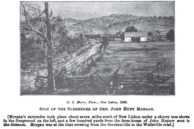
Photo: Henry Howe, from an 1886 photograph, public domain · Wikimedia Commons
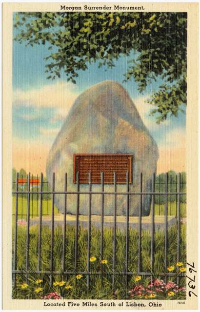
Photo: Tichnor Bros., Inc. (Boston Public Library, Tichnor Brothers collection), public domain · Wikimedia Commons
Local history sources: en.wikipedia.org · genealogytrails.com · commons.wikimedia.org · commons.wikimedia.org · archive.org
Historic places
1 place in Wayne Township, Columbiana County on the National Register of Historic Places. Press a pin or a name for its whole record.
-
Morgan, John H., Surrender SiteSite · West Point · listed 1973
- Address
- 3.1 mi. W of West Point on OH 518
- Where
- West Point, Columbiana County · ZIP 44432
- What it is
- Site
- Listed on the National Register
- 1973
- NRIS reference number
- 73001401
- Coordinates
- 40.69813, -80.74698
National Register file (NPS) ↗ Search Wikipedia ↗ Street map and directions ↗ On the Cracked Buckeye map
Source: National Park Service, National Register of Historic Places point file. The listing year is shown where NPS's certification date agrees with the listing's reference number. Listing recognizes significance; it does not restrict a private owner.
Water
Mostly private wells The water here
- Buckeye Water District - Ohio River53% of residentsOhio River
- Lisbon Village47% of residentsGroundwater wells (6 wells)
- Columbiana County-county Home Rd0% of residentsEast Cold Run Reservoir & Spring Valley Reservoir (Cold Run Creek)
Its ZIP codes
Each ZIP code that touches Wayne Township, Columbiana County, with the share of its residents who live here and the same headline figures as the ZIP page.
| ZIP | Share | Water | Radon | Home value | Schools | Flood |
|---|---|---|---|---|---|---|
| 43945 Salineville | 11% | Mostly private wells | 15.5 pCi/L average radon | Appraisal records without year built | Southern Local · 3 stars overall | 0.4% of residents in the 1% floodplain |
| 44432 Elkrun Township and Lisbon | 4% | Mostly private wells | 6.7 pCi/L average radon | Appraisal records without year built | Lisbon Exempted Village · 3.5 stars overall | 1.1% of residents in the 1% floodplain |
| 44423 Hanover Township and Hanoverton | 1% | Mostly private wells | 11.3 pCi/L average radon | Appraisal records without year built | United Local · 4 stars overall | 1.8% of residents in the 1% floodplain |
Local government
Who holds office in Wayne Township, Columbiana County, how its elections and ballot issues came out, and the state auditor's record.
Money issues on the ballot since 2021: 2 of 3 passed.
Ballot issues
| Date | Issue | For | Against | Result |
|---|---|---|---|---|
| 2023-11-07 | Issue: Wayne Township Tax Levy Roads | 149 | 133 | Passed (52.84% for) |
| 2022-11-08 | Issue: Wayne Township Tax Levy Building | 152 | 181 | Failed (45.65% for) |
| 2021-11-02 | Issue: Wayne Twp Tax Levy Fire | 67 | 41 | Passed (62.04% for) |
Elections for office
| Date | Office | Candidates and votes |
|---|---|---|
| 2023-11-07 | Township Trustee | Everett Bleakney 73, 25.98%; Michael Greathouse 67, 23.84%; Nathaniel Pirogowicz 141, 50.18% |
| 2023-11-07 | Township Fiscal Officer | Carl Gene Bartholow 143, 54.37%; Amanda Greathouse 120, 45.63% |
| 2021-11-02 | Township Trustee | Edward J. Dailey 68, 43.59%; Jim May 88, 56.41% |
Winners in bold. Results from the county board of elections' official canvass unless marked.
Auditor of State record
- No fiscal caution, watch or emergency on the Auditor of State's lists.
- Financial Audit, 2024 to 2025, released 2026-06-23
The county
Columbiana County: 20 ZIP codes, 33 cities, villages and townships, 106,075 people.
Nearby places
Quick answers
What county is Wayne Township, Ohio in?
Wayne Township, Columbiana County is a township in Columbiana County, Ohio, with 797 residents.
When was Wayne Township, Ohio founded?
Wayne Township, Columbiana County was settled by the 1810s-20s; incorporated 1806 (township organized). Founders on record: Columbiana County commissioners. Source
What ZIP code is Wayne Township, Ohio?
Wayne Township, Columbiana County is served by ZIP codes 43945 and 44432; 43945 holds the largest share of its residents.
Where does Wayne Township, Ohio get its water?
The main water source for Wayne Township, Columbiana County (Buckeye Water District - Ohio River): Mostly private wells.
Cite this page
Cite this page as:
Cracked Buckeye, "Wayne Township, Columbiana County", https://crackedbuckeye.com/place/wayne-township-columbiana-county/, built 2026-10-31, accessed [date].
How to cite · Report a correction · Built 2026-10-31
