Local events in Hanoverton
Nothing is posted for Hanoverton itself yet; here is what is on within 10 miles. All local events in Hanoverton
Know a calendar we should watch? Send the link
Checked October 20; the events page is refreshed daily.
How Hanoverton began
Hanoverton was founded in 1813 by Quaker abolitionist James Craig and incorporated as a village in 1836, growing quickly once the Sandy and Beaver Canal reached it in the 1830s -- briefly touching about 2,000 residents -- before the canal's mid-century collapse and the rise of the railroad stalled the town near its canal-era size for good. That arrested growth left a 23-acre core of largely unaltered early-19th-century brick buildings intact long enough to become a National Register historic district in 1977, including the 1837 Spread Eagle Tavern, the 1835 Hanover House, and the 1831 Brick Row; local tradition also credits the village with Underground Railroad tunnels connecting several of these same buildings. Hanoverton counts fewer than 400 residents today, a small canal town preserved largely by having stopped growing.
Settled 1813, platted 1813, incorporated 1836, by James Craig.
Where the name comes from
No source we reviewed documents the specific reasoning behind the name Hanoverton, though it follows the common practice of Ohio towns named for Hanover, Germany or England; the surrounding township carries the same name.
Before the town
No source we reviewed names a specific Native American village, camp or burial site within present Hanoverton's boundaries. The village was founded in 1813, nearly two decades after the region's Native land claims were ceded under the 1785 Treaty of Fort McIntosh and confirmed by the 1795 Treaty of Greenville.
Timeline
- — Quaker abolitionist James Craig founds Hanoverton.
- — The Sandy and Beaver Canal reaches Hanoverton, driving growth toward a peak of about 2,000 residents.
- — The building known as Brick Row is constructed.
- — The Hanover House is built at the intersection of Main and Howard streets.
- — Hanoverton incorporates as a village.
- — The Spread Eagle Tavern opens.
- — Completion of the Cleveland and Pittsburgh Railroad ends the Sandy and Beaver Canal's profitability, and Hanoverton's growth stalls near its canal-era size.
- — A 23-acre Hanoverton Canal Town Historic District, preserving largely unchanged canal-era architecture, is listed on the National Register of Historic Places.
Stories
A canal town frozen at its peak
James Craig, a Quaker abolitionist, founded Hanoverton in 1813, but it was the Sandy and Beaver Canal's arrival in the 1830s that transformed it from a small crossroads into a genuine boomtown, briefly reaching about 2,000 residents as goods and travelers moved through on the water. That boom collapsed almost as fast as it had come: the canal was never reliably profitable, and the 1852 completion of the Cleveland and Pittsburgh Railroad finished it off, leaving Hanoverton's growth stalled at essentially its canal-era size. The upside of that arrested development showed up more than a century later -- because the town never grew enough to tear down and rebuild its early brick storefronts and inns, a 23-acre core of largely unaltered canal-era architecture survived intact long enough to be listed as a National Register historic district in 1977, and the 1837 Spread Eagle Tavern still operates as a restaurant today, one that has hosted a string of modern political figures from Dan Quayle to JD Vance.
A tunnel under Brick Row
Local history in Hanoverton holds that the Underground Railroad ran, quite literally, underground here: an underground passage is said to have connected merchant George Sloan's building known as 'Brick Row' with the home of his brother-in-law, Dr. James Robertson, where a secret room sheltered people escaping slavery, and the Spread Eagle Tavern is likewise said to have had a tunnel feeding into the same network. Whether every physical detail of the tunnels survives verification, the tradition sits comfortably alongside the documented antislavery activity of nearby Salem and Columbiana, part of a broader pattern across Quaker-settled Columbiana County of hidden rooms, sympathetic households and canal-town geography used to move people north.
Photographs
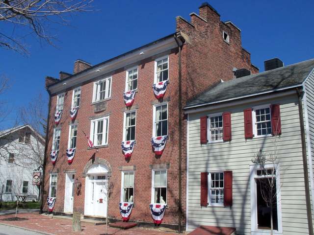
Photo: Roseohioresident (Wikimedia Commons), CC BY-SA 4.0 · Wikimedia Commons
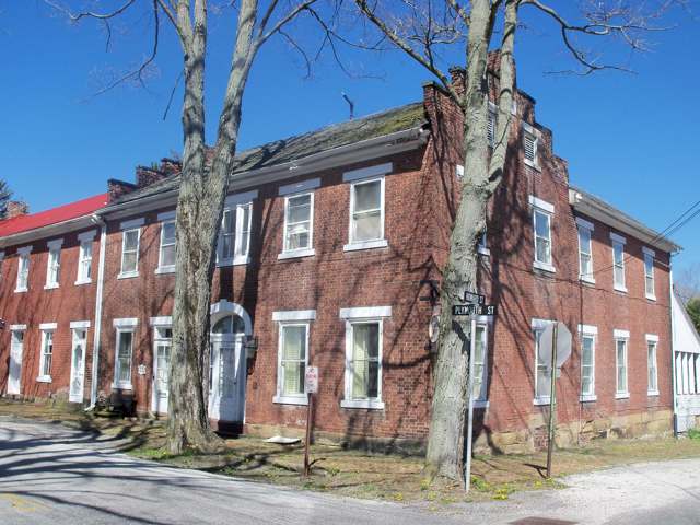
Photo: Roseohioresident (Wikimedia Commons), CC BY-SA 4.0 · Wikimedia Commons
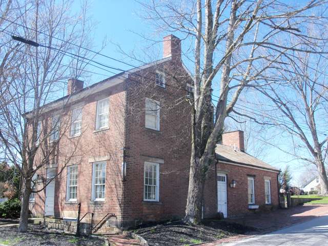
Photo: Roseohioresident (Wikimedia Commons), CC BY-SA 4.0 · Wikimedia Commons
Local history sources: en.wikipedia.org · commons.wikimedia.org · commons.wikimedia.org · commons.wikimedia.org
Water
No water-system data is linked to Hanoverton's ZIP codes yet.
Hospitals, fire stations and more
Inside Hanoverton's boundary: 1 fire or EMS station and 1 Toxics Release Inventory facility. Press a pin or a name for its whole record and its source.
Fire and EMS stations (1)
-
Hanover Township Fire DepartmentHanoverton
- Address
- 10133 Chestnut Lane, Hanoverton, OH 44423
- Coordinates
- 40.75363, -80.92747
USGS National Map structures (source) ↗ Street map and directions ↗
Source: USGS National Map structures (most Ohio records last updated 2019 to 2022), checked against the Columbus and Cleveland station lists. The department that answers a call is set by jurisdiction and mutual aid, not by distance.
Facilities reporting toxic releases (1)
-
National Torch Tip Inc Winona BuildingToxics Release Inventory · Hanoverton
- Address
- 10201 First St., Hanoverton, OH 44423
- County
- Columbiana County
- Status
- Reports to the Toxics Release Inventory (active)
- EPA program ID
- 44423WNNMN10201
- EPA registry ID
- 110000389623
EPA facility record ↗ EPA Facility Registry Service (source) ↗ Street map and directions ↗
Source: EPA Facility Registry Service, Toxics Release Inventory reporters. Reporting a release is required of large users of listed chemicals; it is not by itself a violation.
Its ZIP codes
Each ZIP code that touches Hanoverton, with the share of its residents who live here and the same headline figures as the ZIP page.
| ZIP | Share | Water | Radon | Home value | Schools | Flood |
|---|---|---|---|---|---|---|
| 44423 Hanover Township and Hanoverton | 16% | Mostly private wells | 11.3 pCi/L average radon | Appraisal records without year built | United Local · 4 stars overall | 1.8% of residents in the 1% floodplain |
Local government
How its elections and ballot issues came out and the state auditor's record.
Money issues on the ballot since 2024: 1 of 1 passed.
Ballot issues
| Date | Issue | For | Against | Result |
|---|---|---|---|---|
| 2024-11-05 | Issue: Village of Hanoverton Tax Levy Police | 88 | 78 | Passed (53.01% for) |
Elections for office
| Date | Office | Candidates and votes |
|---|---|---|
| 2023-11-07 | Member of Council | Samuel Hake 80, 44.94%; Scott Sabatino 98, 55.06% |
| 2023-11-07 | Mayor | Gwen Huff 30, 23.62%; Becky Kibler 97, 76.38% |
| 2021-11-02 | Member of Council | Gwendolyn Huff 33, 24.81%; Keith Kaiser 28, 21.05%; Zach Kennedy 38, 28.57%; David L. Phillips 34, 25.56% |
Winners in bold. Results from the county board of elections' official canvass unless marked. The county's results on file run through 2024-11-05; later elections are not loaded yet.
Auditor of State record
- No fiscal caution, watch or emergency on the Auditor of State's lists.
- Basic Audit, 2022 to 2023, released 2024-11-19
On the November 3, 2026 ballot
Statewide question: State Issue 3: Voter ID
Races, candidates and every question for an address: your ballot. County offices and judges are on your county board's sample ballot.
The county
Columbiana County: 20 ZIP codes, 33 cities, villages and townships with pages here, 99,377 people (Census Bureau estimate, July 2025).
Nearby places
Rain and snow
How much has actually fallen on Hanoverton, day by day, from 1892 to now. Daily totals, not averages.
- rain, last 30 days
- 1.52 in
- 2026-10-01 to 2026-10-30
- rain so far in 2026
- 44.4 in
- 9.0 in above normal for the date
- snow so far in 2026
- 35.3 in
- a normal year brings 35.0 in
- a normal year
- 41.3 in
- average of 30 years, 1991-2020
| Month | Rain (in) | Snow (in) | Days counted |
|---|---|---|---|
| October 2026 | 1.52 | — | 30 |
| September 2026 | 5.96 | — | 30 |
| August 2026 | 9.41 | — | 31 |
| July 2026 | 5.75 | — | 31 |
| June 2026 | 3.25 | — | 30 |
| May 2026 | 4.79 | — | 31 |
| April 2026 | 4.80 | — | 30 |
| March 2026 | 5.09 | 3.2 | 31 |
| February 2026 | 1.15 | 6.7 | 28 |
| January 2026 | 2.64 | 25.4 | 31 |
| December 2025 | 3.91 | 13.8 | 31 |
| November 2025 | 1.89 | 0.3 | 30 |
| Wettest year (estimated) | 2020 — 58.0 in |
|---|---|
| Driest year (estimated) | 1991 — 26.1 in |
| Snowiest year (estimated) | 2010 — 71.9 in |
| Wettest day (estimated) | 9 September 2004 — 4.66 in |
| Heaviest snowfall in a day (estimated) | 2 December 1974 — 17.10 in |
| Deepest snow on the ground (estimated) | 29 November 1950 — 22.05 in |
Mostly estimated. Only 7% of these days come from a gauge standing inside Hanoverton - the rest are worked out from the nearest gauges around it, so read them as close estimates rather than readings.
48,866 days of records, 1892-09-01 to 2026-10-30. Source: NOAA NCEI GHCN-Daily, 3,240 gauges in and around Ohio. A day is "gauged" when a gauge standing inside the boundary reported it, and the value is the mean of those gauges. Otherwise it is interpolated by inverse distance from every gauge reporting within 50 miles. Nothing is carried forward, back-filled or smoothed. Against NOAA nClimDiv county monthly precipitation over 136,848 complete county-months (checked 2026-11-01): correlation 0.9515, median absolute difference 0.217 in a month. Built 2026-11-01 from the Cracked Buckeye precipitation archive. Snow is the softer number — snowfall is measured by hand with a ruler, no agency publishes a gridded county snowfall series, and blowing snow defeats every observer.
Environmental permits and filings
What Ohio EPA has on file for Hanoverton: permits, inspections, violations, cleanups and the state loans behind sewer and water work. Every line links to the agency's own document.
- facilities and sites on file
- 2
- those placed on the map inside Hanoverton
| Program | Facilities and sites |
|---|---|
| Hazardous waste | 1 |
| Public drinking water | 1 |
Source: Ohio EPA eDocument portal (edocpub.epa.ohio.gov), indexed 2026-10-14. Facilities are placed on the map from Ohio EPA's own map layers, EPA's Facility Registry, coordinates written in the filings, or a geocoded street address. A permit filed under a private person's name (most are household septic systems) is counted but never named, placed or linked; licenses for individual workers and open-burning notices are left out entirely.
Quick answers
What county is Hanoverton, Ohio in?
Hanoverton is a village in Columbiana County, Ohio, with 354 residents.
When was Hanoverton, Ohio founded?
Hanoverton was settled 1813; laid out 1813; incorporated 1836. Founders on record: James Craig. Source
What ZIP code is Hanoverton, Ohio?
Most of Hanoverton is in ZIP code 44423.
Where does Hanoverton, Ohio get its water?
The main water source for Hanoverton: Mostly private wells.
Cite this page
Cite this page as:
Cracked Buckeye, "Hanoverton, Columbiana County", https://crackedbuckeye.com/place/hanoverton/, built 2026-10-31, accessed [date].
How to cite · Report a correction · Built 2026-10-31