Local events in East Township, Carroll County
Nothing is posted for East Township itself yet; here is what is on within 20 miles. All local events in East Township, Carroll County
Know a calendar we should watch? Send the link
Checked October 20; the events page is refreshed daily.
How East Township, Carroll County began
East Township occupies the northeastern corner of Carroll County, hard against the Columbiana County line, and was originally organized as Franklin Township under Columbiana County before being reassigned to Carroll County and renamed - the only East Township in Ohio. It comprises three rows of sections from the original surveyed Township 14, Range 4, plus six sections taken from Augusta Township by the county commissioners. It has never held an incorporated village; its one platted place, Norris's Norristown of 1832, never amounted to more than a name on a plat map. Its population was 995 at the 1840 census and 808 in 2020.
Settled by 1820s, by reorganized from Franklin Township, Columbiana County, into Carroll County's East Township; exact date not found.
Where the name comes from
The township was Franklin Township when it belonged to Columbiana County; the 1921 county history says it was 'originally under the name of Franklin Township, in a contribution from Columbiana County,' and it became East Township, the county's extreme northeastern subdivision, when Carroll County was organized in 1833. No source gives the reason for 'East' beyond its position.
Before the town
No mound, earthwork, or named Native village has been documented specifically within East Township, and no Carroll County-level history file exists yet to check further. The township's own 1921 county history discusses glacial boulders and coal prospects on its Columbiana County border but records no Native site or encounter. As with the rest of Carroll County, this land passed to the United States under the Treaty of Fort McIntosh (1785), in which the Wyandot, Lenape (Delaware), Ojibwe, and Ottawa were pressured into ceding roughly two-thirds of present Ohio; the historic Lenape and Wyandot both traveled and hunted the upper Little Beaver and Sandy Creek watersheds that this township borders, though no source ties either nation to a specific place inside the township.
Nations recorded here: Wyandot, Lenape (Delaware).
Timeline
- — Daniel Norris plats Norristown in section 29 on September 4; it never grows beyond a name on the map.
- — East Township has 995 people at the 1840 census, the first count after Carroll County's organization; it then covered 24 square miles, made of three rows of sections from original township 14, range 4, plus six sections taken from Augusta Township.
- — The township census is 640; it falls to 606 in 1900 and 572 in 1910.
- — Three-quarters of a mile of the Cleveland and Pittsburgh Railroad runs through the township's northeastern corner, and the county's highest point, 1,375 feet above sea level, lies near its north edge.
- — Population has fallen to 468, the township's low point in the 1840-2020 census record, as the 19th-century farm population thins out.
- — Glade Run Mennonite Church is built south of Kensington, at the crossroads of Bane and Aurora roads, and remains an active congregation in the township.
Stories
A village that stayed a plat
On September 4, 1832, Daniel Norris filed a plat for a village he called Norristown on Section 29 of what would become East Township. Ohio's county histories are full of towns like it: a landowner's optimism, a grid of streets drawn on paper, and then nothing - no depot, no mill, no store district ever grew up to fill the lots. The 1921 county history disposes of Norristown in a single line, noting only that it 'never developed to be known as much of a place.' It is the closest thing East Township has to a founding story, and it is really a story about a town that did not happen.
Photographs
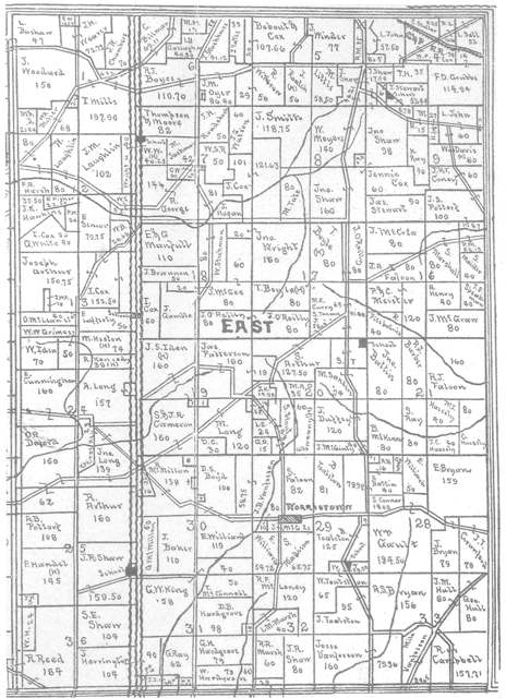
Photo: Linn Boyd Atkinson (1894 map); photographed by Roseohioresident, public domain · Wikimedia Commons
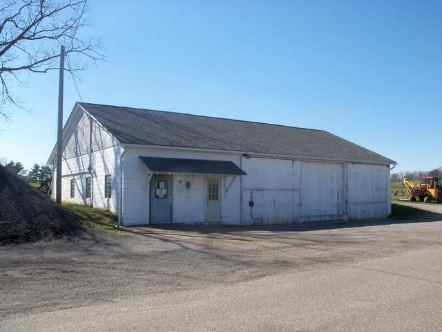
Photo: Roseohioresident, Wikimedia Commons, CC BY-SA 4.0 · Wikimedia Commons
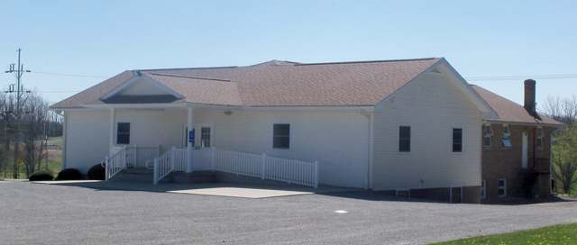
Photo: Roseohioresident, Wikimedia Commons, CC BY-SA 4.0 · Wikimedia Commons
Local history sources: genealogytrails.com · ohiogenealogyexpress.com · en.wikipedia.org · pilgrimministry.org · en.wikipedia.org · commons.wikimedia.org · commons.wikimedia.org · commons.wikimedia.org · archive.org
Water
Mostly private wells The water here
- Buckeye Water District - Ohio River91% of residentsOhio River
- Columbiana County-county Home Rd9% of residentsEast Cold Run Reservoir & Spring Valley Reservoir (Cold Run Creek)
Hospitals, fire stations and more
Inside East Township, Carroll County's boundary: 33 shale and injection wells and 3 spill cases. Press a pin or a name for its whole record and its source.
Shale and injection wells (33)
-
7R 20-14-4 1HUtica shale well
- What it is
- Utica shale well
- Drilled sideways
- Yes
- Operator
- Eog Ohio, Llc
- County
- Carroll County
- API well number
- 34019224650000
- Coordinates
- 40.68572, -80.95201
ODNR oil and gas wells (source) ↗ Street map and directions ↗
The point is the surface well head (the pad); a horizontal well runs a mile or more underground from it.
-
7R 20-14-4 8HUtica shale well
- What it is
- Utica shale well
- Drilled sideways
- Yes
- Operator
- Eog Ohio, Llc
- County
- Carroll County
- API well number
- 34019224630000
- Coordinates
- 40.68567, -80.95194
ODNR oil and gas wells (source) ↗ Street map and directions ↗
The point is the surface well head (the pad); a horizontal well runs a mile or more underground from it.
-
Bainter 25-15-5 10HUtica shale well
- What it is
- Utica shale well
- Drilled sideways
- Yes
- Operator
- Eog Ohio, Llc
- County
- Carroll County
- API well number
- 34019224050000
- Coordinates
- 40.66791, -80.99046
ODNR oil and gas wells (source) ↗ Street map and directions ↗
The point is the surface well head (the pad); a horizontal well runs a mile or more underground from it.
-
Bucey 21-14-4 3 H MMarcellus shale well
- What it is
- Marcellus shale well
- Drilled sideways
- Yes
- Operator
- Eog Ohio, Llc
- County
- Carroll County
- API well number
- 34019220860100
- Coordinates
- 40.68160, -80.92504
ODNR oil and gas wells (source) ↗ Street map and directions ↗
The point is the surface well head (the pad); a horizontal well runs a mile or more underground from it.
-
Bucey 21-14-4 3HUtica shale well
- What it is
- Utica shale well
- Drilled sideways
- Yes
- Operator
- Eog Ohio, Llc
- County
- Carroll County
- API well number
- 34019220740000
- Coordinates
- 40.68159, -80.92496
ODNR oil and gas wells (source) ↗ Street map and directions ↗
The point is the surface well head (the pad); a horizontal well runs a mile or more underground from it.
-
Bucey 21-14-4 5HUtica shale well
- What it is
- Utica shale well
- Drilled sideways
- Yes
- Operator
- Eog Ohio, Llc
- County
- Carroll County
- API well number
- 34019221030000
- Coordinates
- 40.68154, -80.92500
ODNR oil and gas wells (source) ↗ Street map and directions ↗
The point is the surface well head (the pad); a horizontal well runs a mile or more underground from it.
-
Bucey 21-14-4 6HUtica shale well
- What it is
- Utica shale well
- Drilled sideways
- Yes
- Operator
- Eog Ohio, Llc
- County
- Carroll County
- API well number
- 34019221040000
- Coordinates
- 40.68154, -80.92515
ODNR oil and gas wells (source) ↗ Street map and directions ↗
The point is the surface well head (the pad); a horizontal well runs a mile or more underground from it.
-
Buck 24-15-5 1HUtica shale well
- What it is
- Utica shale well
- Drilled sideways
- Yes
- Operator
- Eog Ohio, Llc
- County
- Carroll County
- API well number
- 34019223680000
- Coordinates
- 40.67173, -80.98323
ODNR oil and gas wells (source) ↗ Street map and directions ↗
The point is the surface well head (the pad); a horizontal well runs a mile or more underground from it.
-
Buck 24-15-5 6HUtica shale well
- What it is
- Utica shale well
- Drilled sideways
- Yes
- Operator
- Eog Ohio, Llc
- County
- Carroll County
- API well number
- 34019223490000
- Coordinates
- 40.67168, -80.98326
ODNR oil and gas wells (source) ↗ Street map and directions ↗
The point is the surface well head (the pad); a horizontal well runs a mile or more underground from it.
-
Burry 20-14-4 6HUtica shale well
- What it is
- Utica shale well
- Drilled sideways
- Yes
- Operator
- Eog Ohio, Llc
- County
- Carroll County
- API well number
- 34019223420000
- Coordinates
- 40.68216, -80.93869
ODNR oil and gas wells (source) ↗ Street map and directions ↗
The point is the surface well head (the pad); a horizontal well runs a mile or more underground from it.
-
Burry 20-14-4 8HUtica shale well
- What it is
- Utica shale well
- Drilled sideways
- Yes
- Operator
- Eog Ohio, Llc
- County
- Carroll County
- API well number
- 34019221210000
- Coordinates
- 40.68213, -80.93862
ODNR oil and gas wells (source) ↗ Street map and directions ↗
The point is the surface well head (the pad); a horizontal well runs a mile or more underground from it.
-
Coniglio 7-14-4 1HUtica shale well
- What it is
- Utica shale well
- Drilled sideways
- Yes
- Operator
- Eog Ohio, Llc
- County
- Carroll County
- API well number
- 34019221740000
- Coordinates
- 40.71621, -80.95899
ODNR oil and gas wells (source) ↗ Street map and directions ↗
The point is the surface well head (the pad); a horizontal well runs a mile or more underground from it.
-
Coniglio 7-14-4 3HUtica shale well
- What it is
- Utica shale well
- Drilled sideways
- Yes
- Operator
- Eog Ohio, Llc
- County
- Carroll County
- API well number
- 34019223320000
- Coordinates
- 40.71624, -80.95893
ODNR oil and gas wells (source) ↗ Street map and directions ↗
The point is the surface well head (the pad); a horizontal well runs a mile or more underground from it.
-
Coniglio 7-14-4 6HUtica shale well
- What it is
- Utica shale well
- Drilled sideways
- Yes
- Operator
- Eog Ohio, Llc
- County
- Carroll County
- API well number
- 34019220840100
- Coordinates
- 40.71618, -80.95890
ODNR oil and gas wells (source) ↗ Street map and directions ↗
The point is the surface well head (the pad); a horizontal well runs a mile or more underground from it.
-
G Saltsman 28-14-4 10HUtica shale well
- What it is
- Utica shale well
- Drilled sideways
- Yes
- Operator
- Eog Ohio, Llc
- County
- Carroll County
- API well number
- 34019225780000
- Coordinates
- 40.66181, -80.93564
ODNR oil and gas wells (source) ↗ Street map and directions ↗
The point is the surface well head (the pad); a horizontal well runs a mile or more underground from it.
-
G Saltsman 28-14-4 6HUtica shale well
- What it is
- Utica shale well
- Drilled sideways
- Yes
- Operator
- Eog Ohio, Llc
- County
- Carroll County
- API well number
- 34019225620000
- Coordinates
- 40.66171, -80.93558
ODNR oil and gas wells (source) ↗ Street map and directions ↗
The point is the surface well head (the pad); a horizontal well runs a mile or more underground from it.
-
G Saltsman 28-14-4 8HUtica shale well
- What it is
- Utica shale well
- Drilled sideways
- Yes
- Operator
- Eog Ohio, Llc
- County
- Carroll County
- API well number
- 34019225770000
- Coordinates
- 40.66176, -80.93561
ODNR oil and gas wells (source) ↗ Street map and directions ↗
The point is the surface well head (the pad); a horizontal well runs a mile or more underground from it.
-
Haley 8-14-4 10HUtica shale well
- What it is
- Utica shale well
- Drilled sideways
- Yes
- Operator
- Eog Ohio, Llc
- County
- Carroll County
- API well number
- 34019222530000
- Coordinates
- 40.71354, -80.94368
ODNR oil and gas wells (source) ↗ Street map and directions ↗
The point is the surface well head (the pad); a horizontal well runs a mile or more underground from it.
-
Haley 8-14-4 8HUtica shale well
- What it is
- Utica shale well
- Drilled sideways
- Yes
- Operator
- Eog Ohio, Llc
- County
- Carroll County
- API well number
- 34019222110000
- Coordinates
- 40.71353, -80.94375
ODNR oil and gas wells (source) ↗ Street map and directions ↗
The point is the surface well head (the pad); a horizontal well runs a mile or more underground from it.
-
Heston 13-15-5 10HUtica shale well
- What it is
- Utica shale well
- Drilled sideways
- Yes
- Operator
- Eog Ohio, Llc
- County
- Carroll County
- API well number
- 34019225910000
- Coordinates
- 40.68517, -80.97878
ODNR oil and gas wells (source) ↗ Street map and directions ↗
The point is the surface well head (the pad); a horizontal well runs a mile or more underground from it.
-
Heston 13-15-5 1HUtica shale well
- What it is
- Utica shale well
- Drilled sideways
- Yes
- Operator
- Eog Ohio, Llc
- County
- Carroll County
- API well number
- 34019225900000
- Coordinates
- 40.68523, -80.97889
ODNR oil and gas wells (source) ↗ Street map and directions ↗
The point is the surface well head (the pad); a horizontal well runs a mile or more underground from it.
-
Heston 13-15-5 6HUtica shale well
- What it is
- Utica shale well
- Drilled sideways
- Yes
- Operator
- Eog Ohio, Llc
- County
- Carroll County
- API well number
- 34019225890000
- Coordinates
- 40.68516, -80.97892
ODNR oil and gas wells (source) ↗ Street map and directions ↗
The point is the surface well head (the pad); a horizontal well runs a mile or more underground from it.
-
Heston 13-15-5 8HUtica shale well
- What it is
- Utica shale well
- Drilled sideways
- Yes
- Operator
- Eog Ohio, Llc
- County
- Carroll County
- API well number
- 34019225920000
- Coordinates
- 40.68517, -80.97885
ODNR oil and gas wells (source) ↗ Street map and directions ↗
The point is the surface well head (the pad); a horizontal well runs a mile or more underground from it.
-
Leslie 9-14-4 5HUtica shale well · Well drilled
- What it is
- Utica shale well
- Drilled sideways
- Yes
- Status (ODNR)
- Well drilled
- Operator
- Eog Ohio, Llc
- County
- Carroll County
- API well number
- 34019225950000
- Coordinates
- 40.71410, -80.93312
ODNR oil and gas wells (source) ↗ Street map and directions ↗
The point is the surface well head (the pad); a horizontal well runs a mile or more underground from it.
-
Leslie 9-14-4 8HUtica shale well
- What it is
- Utica shale well
- Drilled sideways
- Yes
- Operator
- Eog Ohio, Llc
- County
- Carroll County
- API well number
- 34019222540000
- Coordinates
- 40.71404, -80.93315
ODNR oil and gas wells (source) ↗ Street map and directions ↗
The point is the surface well head (the pad); a horizontal well runs a mile or more underground from it.
-
Mills 1-15-5 1HUtica shale well
- What it is
- Utica shale well
- Drilled sideways
- Yes
- Operator
- Eog Ohio, Llc
- County
- Carroll County
- API well number
- 34019222880000
- Coordinates
- 40.71453, -80.97736
ODNR oil and gas wells (source) ↗ Street map and directions ↗
The point is the surface well head (the pad); a horizontal well runs a mile or more underground from it.
-
Mills 1-15-5 8HUtica shale well
- What it is
- Utica shale well
- Drilled sideways
- Yes
- Operator
- Eog Ohio, Llc
- County
- Carroll County
- API well number
- 34019222870000
- Coordinates
- 40.71446, -80.97733
ODNR oil and gas wells (source) ↗ Street map and directions ↗
The point is the surface well head (the pad); a horizontal well runs a mile or more underground from it.
-
S Farms 32-14-4 3HUtica shale well
- What it is
- Utica shale well
- Drilled sideways
- Yes
- Operator
- Eog Ohio, Llc
- County
- Carroll County
- API well number
- 34019223790000
- Coordinates
- 40.64736, -80.94813
ODNR oil and gas wells (source) ↗ Street map and directions ↗
The point is the surface well head (the pad); a horizontal well runs a mile or more underground from it.
-
S Farms 32-14-4 8HUtica shale well
- What it is
- Utica shale well
- Drilled sideways
- Yes
- Operator
- Eog Ohio, Llc
- County
- Carroll County
- API well number
- 34019223750000
- Coordinates
- 40.64730, -80.94801
ODNR oil and gas wells (source) ↗ Street map and directions ↗
The point is the surface well head (the pad); a horizontal well runs a mile or more underground from it.
-
Schmuck 31-14-4 10HUtica shale well
- What it is
- Utica shale well
- Drilled sideways
- Yes
- Operator
- Eog Ohio, Llc
- County
- Carroll County
- API well number
- 34019223340000
- Coordinates
- 40.64552, -80.95968
ODNR oil and gas wells (source) ↗ Street map and directions ↗
The point is the surface well head (the pad); a horizontal well runs a mile or more underground from it.
-
Schmuck 31-14-4 1HUtica shale well
- What it is
- Utica shale well
- Drilled sideways
- Yes
- Operator
- Eog Ohio, Llc
- County
- Carroll County
- API well number
- 34019222430000
- Coordinates
- 40.64555, -80.95977
ODNR oil and gas wells (source) ↗ Street map and directions ↗
The point is the surface well head (the pad); a horizontal well runs a mile or more underground from it.
-
Schmuck 31-14-4 6HUtica shale well
- What it is
- Utica shale well
- Drilled sideways
- Yes
- Operator
- Eog Ohio, Llc
- County
- Carroll County
- API well number
- 34019223390000
- Coordinates
- 40.64549, -80.95977
ODNR oil and gas wells (source) ↗ Street map and directions ↗
The point is the surface well head (the pad); a horizontal well runs a mile or more underground from it.
-
Schmuck 31-14-4 8HUtica shale well
- What it is
- Utica shale well
- Drilled sideways
- Yes
- Operator
- Eog Ohio, Llc
- County
- Carroll County
- API well number
- 34019221120000
- Coordinates
- 40.64546, -80.95968
ODNR oil and gas wells (source) ↗ Street map and directions ↗
The point is the surface well head (the pad); a horizontal well runs a mile or more underground from it.
Source: ODNR Division of Oil and Gas Resources well inventory (September 2026): drilled Utica, Marcellus and horizontal wells and Class II injection wells not plugged. Older vertical wells are on the full map.
Spills reported since 2021 (3)
-
Bentonite / Drilling Mud2023-07-20 · Null
- Reported
- 2023-07-20
- What spilled
- Bentonite / Drilling Mud
- Largest amount reported
- 100 gallons
- Where
- Null, Carroll County
- Ohio EPA district office
- NEDO
- Ohio EPA case number
- 2307EPA0001223
Ohio EPA spill reports (source) ↗ Street map and directions ↗
-
Bentonite / Drilling Mud2023-07-19 · East Twp
- Reported
- 2023-07-19
- What spilled
- Bentonite / Drilling Mud
- Largest amount reported
- 100 gallons
- Where
- East Twp, Carroll County
- Ohio EPA district office
- NEDO
- Ohio EPA case number
- 2307EPA0001217
Ohio EPA spill reports (source) ↗ Street map and directions ↗
-
Bentonite / Drilling Mud2023-07-19 · East Twp
- Reported
- 2023-07-19
- What spilled
- Bentonite / Drilling Mud
- Largest amount reported
- 200 gallons
- Where
- East Twp, Carroll County
- Ohio EPA district office
- NEDO
- Ohio EPA case number
- 2307EPA0001214
Ohio EPA spill reports (source) ↗ Street map and directions ↗
Source: Ohio EPA emergency response spill reports, 2021 to September 2026, one point per case where Ohio EPA placed it. A report is what the caller or responder recorded; amounts are often blank or estimated.
Its ZIP codes
Each ZIP code that touches East Township, Carroll County, with the share of its residents who live here and the same headline figures as the ZIP page.
| ZIP | Share | Water | Radon | Home value | Schools | Flood |
|---|---|---|---|---|---|---|
| 44427 East Township and Kensington | 36% | Mostly private wells | 14.8 pCi/L average radon | Appraisal records without year built | Carrollton Exempted Village · 4 stars overall | 6.5% of residents in the 1% floodplain |
| 44651 Fox Township and Mechanicstown | 18% | Mostly private wells | 2.6 pCi/L average radon | Median year built 1973 | Carrollton Exempted Village · 4 stars overall | 0.0% of residents in the 1% floodplain |
| 43945 Salineville | 4% | Mostly private wells | 15.5 pCi/L average radon | Appraisal records without year built | Southern Local · 3 stars overall | 0.4% of residents in the 1% floodplain |
The county
Columbiana County: 20 ZIP codes, 33 cities, villages and townships, 106,075 people.
Nearby places
Quick answers
What county is East Township, Ohio in?
East Township, Carroll County is a township in Columbiana County, Ohio, with 808 residents.
When was East Township, Ohio founded?
East Township, Carroll County was settled by 1820s. Founders on record: reorganized from Franklin Township, Columbiana County, into Carroll County's East Township; exact date not found. Source
How did East Township, Ohio get its name?
The township was Franklin Township when it belonged to Columbiana County; the 1921 county history says it was 'originally under the name of Franklin Township, in a contribution from Columbiana County,' and it became East Township, the county's extreme northeastern subdivision, when Carroll County was organized in 1833. Source
What ZIP code is East Township, Ohio?
East Township, Carroll County is served by ZIP codes 44427, 44651 and 43945; 44427 holds the largest share of its residents.
Where does East Township, Ohio get its water?
The main water source for East Township, Carroll County (Buckeye Water District - Ohio River): Mostly private wells.
Cite this page
Cite this page as:
Cracked Buckeye, "East Township, Carroll County", https://crackedbuckeye.com/place/east-township-carroll-county/, built 2026-10-31, accessed [date].
How to cite · Report a correction · Built 2026-10-31
