Local events in Pultney Township, Belmont County
Nothing is posted for Pultney Township itself yet; here is what is on within 10 miles. All local events in Pultney Township, Belmont County
Know a calendar we should watch? Send the link
Checked October 20; the events page is refreshed daily.
How Pultney Township, Belmont County began
Pultney Township was organized in 1801, one of Belmont County's original townships, stretching along the Ohio River in the county's eastern reach. By 1833 it held a store or two, several grist and flour mills, sawmills, and a woolen factory; over the following century its Ohio River villages, Bellaire and Shadyside, industrialized around glass and rail while its inland coal camps, including Neffs and Lansing, mined the hills. The township's worst single event was the March 16, 1940 explosion at the Hanna Coal Company's No. 10 Mine at Willow Grove, near Neffs, which killed 72 men. Rock Hill Presbyterian Church, rebuilt in 1903 after an 1895 fire, stands northwest of Bellaire as the township's National Register-listed landmark.
Incorporated 1801, by organized as an original Belmont County township.
Where the name comes from
No documented explanation of the township's name was found in the sources consulted; Ohio has only this one Pultney Township statewide.
Before the town
No Native village, camp, or trail specific to Pultney Township was found in the sources consulted. The township's Ohio River frontage lay within the general eighteenth-century travel and hunting range, shared among the Lenape (Delaware), Shawnee, Wyandot, and Mingo before the treaty cessions of 1785 and 1795.
Timeline
- — The area later known as Neffs, in the township's interior, is settled, taking its name from the Neffs (Neife) family, who had come to Belmont County from Switzerland by way of Pennsylvania and Maryland.
- — Pultney Township is organized as one of Belmont County's original townships.
- — The township is recorded as containing one or two stores, four flouring mills, three or four gristmills, several sawmills, and a woolen factory.
- — Neffs gets its own post office, formalizing the community within the township.
- — The original Rock Hill Presbyterian Church building northwest of Bellaire is destroyed by fire.
- — The present Rock Hill Presbyterian Church, designed by architect George D. Giffin in the Late Gothic Revival style, is built for $13,000 to replace the burned church.
- — An explosion at the Hanna Coal Company's No. 10 Mine at Willow Grove, near Neffs, kills 72 men around 11:00 a.m. on March 16.
- — Rock Hill Presbyterian Church is added to the National Register of Historic Places on February 18.
Stories
Seventy-two men at Willow Grove
On the morning of March 16, 1940, an explosion tore through the Hanna Coal Company's No. 10 Mine at Willow Grove, in the hills near Neffs in Pultney Township. Around 11:00 a.m., the blast killed 72 miners, making it one of the deadliest coal-mining disasters in Belmont County's long mining history. Neffs itself was a small farming and milling community, settled in 1797 by families including the Swiss-descended Neffs for whom it was named, that had grown a post office by 1892 and, like much of the surrounding township, come to depend on the coal seams beneath it for work. The disaster is remembered locally as one of the costliest days in the region's mining era, a reminder of how central, and how dangerous, coal work had become to the township's coal camps by the mid-twentieth century.
A church rebuilt after fire
The Presbyterian congregation northwest of Bellaire had already been meeting for decades when fire destroyed their church building in 1895. It took the congregation until 1903 to complete a replacement, but when they did, they built something considerably grander than what had burned: a red brick, Late Gothic Revival building designed by architect George D. Giffin, cross-shaped in plan, with a hipped roof, dentil molding, a bell tower topped by a tall spire, and an interior where the original oak pews were arranged in concentric arches to improve both sightlines and acoustics, all for a construction cost of $13,000. The building has stood since, and was added to the National Register of Historic Places in 2009.
Photographs
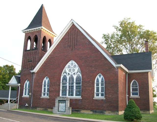
Photo: Bwsmith84, Wikimedia Commons, CC BY 3.0 · Wikimedia Commons
Local history sources: en.wikipedia.org · en.wikipedia.org · en.wikipedia.org · en.wikipedia.org · commons.wikimedia.org
Historic places
1 place in Pultney Township, Belmont County on the National Register of Historic Places. Press a pin or a name for its whole record.
-
Rock Hill Presbyterian ChurchBuilding · Bellaire · listed 2009
- Address
- 56244 High Ridge Rd.
- Where
- Bellaire, Belmont County · ZIP 43906
- What it is
- Building
- Listed on the National Register
- 2009
- NRIS reference number
- 09000169
- Coordinates
- 40.03738, -80.77315
National Register file (NPS) ↗ Search Wikipedia ↗ Street map and directions ↗ On the Cracked Buckeye map
Source: National Park Service, National Register of Historic Places point file. The listing year is shown where NPS's certification date agrees with the listing's reference number. Listing recognizes significance; it does not restrict a private owner.
Water
Mostly private wells The water here
- Bellaire Public Water System72% of residentsOhio River (via bank infiltration wells)
- Belmont Co. Sanitary District 319% of residentsOhio River valley aquifer (wells)
- Shadyside Public Water System9% of residentsGroundwater wells (2 wells)
- St. Clairsville, City Of0% of residentsSt. Clairsville Main & Provident Reservoirs (local runoff)
- York Township Water Authority0% of residentsGroundwater wells (3 wells)
Hospitals, fire stations and more
Inside Pultney Township, Belmont County's boundary: 1 nursing home, 2 fire and EMS stations, 2 public schools, 3 poor-rated bridges, 1 museum, 36 shale and injection wells and 15 spill cases. Press a pin or a name for its whole record and its source.
Nursing homes (1)
-
Country Club Retirement Ctr Iv1 of 5 stars · Bellaire
- Address
- 55801 Conno-Mara Drive, Bellaire, OH 43906
- Certified beds
- 62
- Residents on an average day
- 43
- Medicare overall rating
- 1 of 5 stars
- Health inspections
- 1 of 5 stars
- Staffing
- 1 of 5 stars
- Quality measures
- 4 of 5 stars
- Penalties since 2023
- none
- Ownership
- For profit - Limited Liability company
- Chain
- COUNTRY CLUB REHABILITATION CAMPUS
- Continuing care retirement community
- Yes
- Takes
- Medicare and Medicaid
- Phone
- (740) 676-2300
- Medicare ID
- 365699
Medicare Care Compare ↗ CMS nursing home data (source) ↗ Street map and directions ↗
Source: CMS Care Compare nursing home provider and penalties files; Medicare star ratings run 1 to 5.
Fire and EMS stations (2)
-
Neffs Fire DepartmentNeffs
- Address
- 54044 Pike Street, Neffs, OH 43906
- Coordinates
- 40.02698, -80.81433
USGS National Map structures (source) ↗ Street map and directions ↗
-
Spirit of 76 Volunteer Fire DepartmentBellaire
- Address
- 53890 Key Bellaire Road, Bellaire, OH 43906
- Coordinates
- 39.99720, -80.81737
USGS National Map structures (source) ↗ Street map and directions ↗
Source: USGS National Map structures (most Ohio records last updated 2019 to 2022), checked against the Columbus and Cleveland station lists. The department that answers a call is set by jurisdiction and mutual aid, not by distance.
Public schools (2)
-
Bellaire Elementary School3.5 of 5 stars · Bellaire
- Address
- 53299 Pike St, Bellaire, OH 43906
- School district
- Bellaire City School District
- Kind (NCES)
- Regular School
- Students, 2023-24
- 482
- Teachers (full-time equivalent)
- 28
- Report card, 2025-26
- 3.5 of 5 stars
- Performance index
- 86.7%
- Ohio building IRN
- 142505
- NCES school ID
- 390435704192
NCES school record ↗ Ohio School Report Card ↗ Street map and directions ↗
-
Bellaire Middle School4 of 5 stars · Bellaire
- Address
- 54555 Bellaire-Neffs Rd, Bellaire, OH 43906
- School district
- Bellaire City School District
- Kind (NCES)
- Regular School
- Students, 2023-24
- 336
- Teachers (full-time equivalent)
- 27
- Report card, 2025-26
- 4 of 5 stars
- Performance index
- 82.8%
- Ohio building IRN
- 142513
- NCES school ID
- 390435704193
NCES school record ↗ Ohio School Report Card ↗ Street map and directions ↗
Source: NCES EDGE public school locations 2024-25 and Common Core of Data 2023-24 (type, students, teachers); Ohio School Report Cards 2025-26 (Department of Education and Workforce), matched by name within the district.
Bridges rated poor (3)
-
Ch 3 over Moss RunPoor · built 1938
- Condition
- Poor: a deck, superstructure, substructure or culvert rated 4 or below on the 0 to 9 scale
- What it is
- Bridge
- Built
- 1938
- Length
- 16 ft
- Owner
- County
- Vehicles a day
- 477
- Coordinates
- 40.02596, -80.79522
National Bridge Inventory (source) ↗ Street map and directions ↗
-
Ch 42 over Brooks RunPoor · built 1925
- Condition
- Poor: a deck, superstructure, substructure or culvert rated 4 or below on the 0 to 9 scale
- What it is
- Bridge
- Built
- 1925
- Length
- 8 ft
- Owner
- County
- Vehicles a day
- 531
- Coordinates
- 40.01094, -80.76592
National Bridge Inventory (source) ↗ Street map and directions ↗
-
TR 1195 Quincy over Mcmahon CreekPoor · built 1945
- Condition
- Poor: a deck, superstructure, substructure or culvert rated 4 or below on the 0 to 9 scale
- What it is
- Bridge
- Built
- 1945
- Length
- 31 ft
- Owner
- County
- Vehicles a day
- 451
- Coordinates
- 40.02451, -80.81246
National Bridge Inventory (source) ↗ Street map and directions ↗
Source: FHWA National Bridge Inventory 2025. "Poor" means one major part rated 4 or below on the 0 to 9 scale; it calls for repair, not closing, unless the state posts or closes the bridge.
Museums, historical societies, gardens and zoos (1)
-
National Imperial Glass MuseumMuseum · Bellaire
- What it is
- Museum
- City
- Bellaire
- Coordinates
- 40.01737, -80.76369
Search Wikipedia ↗ IMLS Museum Data Files (source) ↗ Street map and directions ↗
The museum list is IMLS's 2018 file; a museum may have closed or moved since.
Source: IMLS Museum Data Files, 2018.
Shale and injection wells (36)
-
Fleagane N Plt Bl 3HUtica shale well
- What it is
- Utica shale well
- Drilled sideways
- Yes
- Operator
- Ascent Resources Utica Llc
- County
- Belmont County
- API well number
- 34013215450000
- Coordinates
- 40.04502, -80.79715
ODNR oil and gas wells (source) ↗ Street map and directions ↗
The point is the surface well head (the pad); a horizontal well runs a mile or more underground from it.
-
Fleagane Ne Plt Bl 5HUtica shale well
- What it is
- Utica shale well
- Drilled sideways
- Yes
- Operator
- Ascent Resources Utica Llc
- County
- Belmont County
- API well number
- 34013215470000
- Coordinates
- 40.04507, -80.79711
ODNR oil and gas wells (source) ↗ Street map and directions ↗
The point is the surface well head (the pad); a horizontal well runs a mile or more underground from it.
-
Fleagane Ne Plt Bl 7HUtica shale well
- What it is
- Utica shale well
- Drilled sideways
- Yes
- Operator
- Ascent Resources Utica Llc
- County
- Belmont County
- API well number
- 34013215480000
- Coordinates
- 40.04511, -80.79707
ODNR oil and gas wells (source) ↗ Street map and directions ↗
The point is the surface well head (the pad); a horizontal well runs a mile or more underground from it.
-
Fleagane Nw Plt Bl 1HUtica shale well
- What it is
- Utica shale well
- Drilled sideways
- Yes
- Operator
- Ascent Resources Utica Llc
- County
- Belmont County
- API well number
- 34013215460000
- Coordinates
- 40.04498, -80.79720
ODNR oil and gas wells (source) ↗ Street map and directions ↗
The point is the surface well head (the pad); a horizontal well runs a mile or more underground from it.
-
Fleagane Se Plt Bl 6HUtica shale well
- What it is
- Utica shale well
- Drilled sideways
- Yes
- Operator
- Ascent Resources Utica Llc
- County
- Belmont County
- API well number
- 34013214880000
- Coordinates
- 40.04488, -80.79729
ODNR oil and gas wells (source) ↗ Street map and directions ↗
The point is the surface well head (the pad); a horizontal well runs a mile or more underground from it.
-
Fleagane Se Plt Bl 8HUtica shale well
- What it is
- Utica shale well
- Drilled sideways
- Yes
- Operator
- Ascent Resources Utica Llc
- County
- Belmont County
- API well number
- 34013214890000
- Coordinates
- 40.04492, -80.79725
ODNR oil and gas wells (source) ↗ Street map and directions ↗
The point is the surface well head (the pad); a horizontal well runs a mile or more underground from it.
-
Fleagane Sw Plt Bl 2HUtica shale well
- What it is
- Utica shale well
- Drilled sideways
- Yes
- Operator
- Ascent Resources Utica Llc
- County
- Belmont County
- API well number
- 34013214860000
- Coordinates
- 40.04479, -80.79738
ODNR oil and gas wells (source) ↗ Street map and directions ↗
The point is the surface well head (the pad); a horizontal well runs a mile or more underground from it.
-
Fleagane Sw Plt Bl 4HUtica shale well
- What it is
- Utica shale well
- Drilled sideways
- Yes
- Operator
- Ascent Resources Utica Llc
- County
- Belmont County
- API well number
- 34013214870000
- Coordinates
- 40.04483, -80.79733
ODNR oil and gas wells (source) ↗ Street map and directions ↗
The point is the surface well head (the pad); a horizontal well runs a mile or more underground from it.
-
Miller Mc Plt Bl M14HMarcellus shale well
- What it is
- Marcellus shale well
- Drilled sideways
- Yes
- Operator
- Ascent Resources Utica Llc
- County
- Belmont County
- API well number
- 34013216240000
- Coordinates
- 40.00068, -80.78763
ODNR oil and gas wells (source) ↗ Street map and directions ↗
The point is the surface well head (the pad); a horizontal well runs a mile or more underground from it.
-
Miller Se Plt Bl 12HUtica shale well
- What it is
- Utica shale well
- Drilled sideways
- Yes
- Operator
- Ascent Resources Utica Llc
- County
- Belmont County
- API well number
- 34013216230000
- Coordinates
- 40.00079, -80.78763
ODNR oil and gas wells (source) ↗ Street map and directions ↗
The point is the surface well head (the pad); a horizontal well runs a mile or more underground from it.
-
Miller Sw Plt Bl 10HUtica shale well
- What it is
- Utica shale well
- Drilled sideways
- Yes
- Operator
- Ascent Resources Utica Llc
- County
- Belmont County
- API well number
- 34013216220000
- Coordinates
- 40.00074, -80.78763
ODNR oil and gas wells (source) ↗ Street map and directions ↗
The point is the surface well head (the pad); a horizontal well runs a mile or more underground from it.
-
Miller Unit A 4HUtica shale well
- What it is
- Utica shale well
- Drilled sideways
- Yes
- Operator
- Ascent Resources Utica Llc
- County
- Belmont County
- API well number
- 34013209660000
- Coordinates
- 40.00083, -80.78772
ODNR oil and gas wells (source) ↗ Street map and directions ↗
The point is the surface well head (the pad); a horizontal well runs a mile or more underground from it.
-
Miller Unit A 6HUtica shale well
- What it is
- Utica shale well
- Drilled sideways
- Yes
- Operator
- Ascent Resources Utica Llc
- County
- Belmont County
- API well number
- 34013213470000
- Coordinates
- 40.00079, -80.78772
ODNR oil and gas wells (source) ↗ Street map and directions ↗
The point is the surface well head (the pad); a horizontal well runs a mile or more underground from it.
-
Miller Unit B 3HUtica shale well
- What it is
- Utica shale well
- Drilled sideways
- Yes
- Operator
- Ascent Resources Utica Llc
- County
- Belmont County
- API well number
- 34013209950000
- Coordinates
- 40.00087, -80.78772
ODNR oil and gas wells (source) ↗ Street map and directions ↗
The point is the surface well head (the pad); a horizontal well runs a mile or more underground from it.
-
Miller Unit C 2HUtica shale well
- What it is
- Utica shale well
- Drilled sideways
- Yes
- Operator
- Ascent Resources Utica Llc
- County
- Belmont County
- API well number
- 34013210000000
- Coordinates
- 40.00091, -80.78772
ODNR oil and gas wells (source) ↗ Street map and directions ↗
The point is the surface well head (the pad); a horizontal well runs a mile or more underground from it.
-
Miller Unit C 8HUtica shale well
- What it is
- Utica shale well
- Drilled sideways
- Yes
- Operator
- Ascent Resources Utica Llc
- County
- Belmont County
- API well number
- 34013214060000
- Coordinates
- 40.00075, -80.78772
ODNR oil and gas wells (source) ↗ Street map and directions ↗
The point is the surface well head (the pad); a horizontal well runs a mile or more underground from it.
-
Robinson C Plt Bl 6HUtica shale well
- What it is
- Utica shale well
- Drilled sideways
- Yes
- Operator
- Ascent Resources Utica Llc
- County
- Belmont County
- API well number
- 34013216340000
- Coordinates
- 40.01218, -80.76986
ODNR oil and gas wells (source) ↗ Street map and directions ↗
The point is the surface well head (the pad); a horizontal well runs a mile or more underground from it.
-
Robinson Sw Plt Bl 2HUtica shale well
- What it is
- Utica shale well
- Drilled sideways
- Yes
- Operator
- Ascent Resources Utica Llc
- County
- Belmont County
- API well number
- 34013216320000
- Coordinates
- 40.01229, -80.76985
ODNR oil and gas wells (source) ↗ Street map and directions ↗
The point is the surface well head (the pad); a horizontal well runs a mile or more underground from it.
-
Robinson W Plt Bl 4HUtica shale well
- What it is
- Utica shale well
- Drilled sideways
- Yes
- Operator
- Ascent Resources Utica Llc
- County
- Belmont County
- API well number
- 34013216330000
- Coordinates
- 40.01223, -80.76985
ODNR oil and gas wells (source) ↗ Street map and directions ↗
The point is the surface well head (the pad); a horizontal well runs a mile or more underground from it.
-
Shimble 210284 1DUtica shale well
- What it is
- Utica shale well
- Drilled sideways
- Yes
- Operator
- Gulfport Appalachia Llc
- County
- Belmont County
- API well number
- 34013213510000
- Coordinates
- 40.04986, -80.82031
ODNR oil and gas wells (source) ↗ Street map and directions ↗
The point is the surface well head (the pad); a horizontal well runs a mile or more underground from it.
-
Shimble 210284 3BUtica shale well
- What it is
- Utica shale well
- Drilled sideways
- Yes
- Operator
- Gulfport Appalachia Llc
- County
- Belmont County
- API well number
- 34013213530000
- Coordinates
- 40.04980, -80.82039
ODNR oil and gas wells (source) ↗ Street map and directions ↗
The point is the surface well head (the pad); a horizontal well runs a mile or more underground from it.
-
Shimble 210284 4AUtica shale well
- What it is
- Utica shale well
- Drilled sideways
- Yes
- Operator
- Gulfport Appalachia Llc
- County
- Belmont County
- API well number
- 34013213540000
- Coordinates
- 40.04977, -80.82043
ODNR oil and gas wells (source) ↗ Street map and directions ↗
The point is the surface well head (the pad); a horizontal well runs a mile or more underground from it.
-
Violet Unit 5HUtica shale well
- What it is
- Utica shale well
- Drilled sideways
- Yes
- Operator
- Ascent Resources Utica Llc
- County
- Belmont County
- API well number
- 34013209640000
- Coordinates
- 40.01453, -80.79241
ODNR oil and gas wells (source) ↗ Street map and directions ↗
The point is the surface well head (the pad); a horizontal well runs a mile or more underground from it.
-
Wassmann A Plt Bl 1HUtica shale well
- What it is
- Utica shale well
- Drilled sideways
- Yes
- Operator
- Ascent Resources Utica Llc
- County
- Belmont County
- API well number
- 34013215570000
- Coordinates
- 39.98983, -80.79144
ODNR oil and gas wells (source) ↗ Street map and directions ↗
The point is the surface well head (the pad); a horizontal well runs a mile or more underground from it.
-
Wassmann B Plt Bl 2HUtica shale well
- What it is
- Utica shale well
- Drilled sideways
- Yes
- Operator
- Ascent Resources Utica Llc
- County
- Belmont County
- API well number
- 34013215580000
- Coordinates
- 39.98984, -80.79137
ODNR oil and gas wells (source) ↗ Street map and directions ↗
The point is the surface well head (the pad); a horizontal well runs a mile or more underground from it.
-
Wassmann B Plt Bl 4HUtica shale well
- What it is
- Utica shale well
- Drilled sideways
- Yes
- Operator
- Ascent Resources Utica Llc
- County
- Belmont County
- API well number
- 34013215590000
- Coordinates
- 39.98985, -80.79130
ODNR oil and gas wells (source) ↗ Street map and directions ↗
The point is the surface well head (the pad); a horizontal well runs a mile or more underground from it.
-
Wassmann Unit A 6HUtica shale well
- What it is
- Utica shale well
- Drilled sideways
- Yes
- Operator
- Ascent Resources Utica Llc
- County
- Belmont County
- API well number
- 34013209940000
- Coordinates
- 39.98980, -80.79160
ODNR oil and gas wells (source) ↗ Street map and directions ↗
The point is the surface well head (the pad); a horizontal well runs a mile or more underground from it.
-
Wassmann Unit B 5HUtica shale well
- What it is
- Utica shale well
- Drilled sideways
- Yes
- Operator
- Ascent Resources Utica Llc
- County
- Belmont County
- API well number
- 34013209700000
- Coordinates
- 39.98980, -80.79155
ODNR oil and gas wells (source) ↗ Street map and directions ↗
The point is the surface well head (the pad); a horizontal well runs a mile or more underground from it.
-
Wise Ne Plt Bl 5HUtica shale well
- What it is
- Utica shale well
- Drilled sideways
- Yes
- Operator
- Ascent Resources Utica Llc
- County
- Belmont County
- API well number
- 34013215830000
- Coordinates
- 40.04301, -80.78083
ODNR oil and gas wells (source) ↗ Street map and directions ↗
The point is the surface well head (the pad); a horizontal well runs a mile or more underground from it.
-
Wise Ne Plt Bl 7HUtica shale well
- What it is
- Utica shale well
- Drilled sideways
- Yes
- Operator
- Ascent Resources Utica Llc
- County
- Belmont County
- API well number
- 34013215840000
- Coordinates
- 40.04307, -80.78082
ODNR oil and gas wells (source) ↗ Street map and directions ↗
The point is the surface well head (the pad); a horizontal well runs a mile or more underground from it.
-
Wise Nw Plt Bl 1HUtica shale well
- What it is
- Utica shale well
- Drilled sideways
- Yes
- Operator
- Ascent Resources Utica Llc
- County
- Belmont County
- API well number
- 34013215810000
- Coordinates
- 40.04290, -80.78084
ODNR oil and gas wells (source) ↗ Street map and directions ↗
The point is the surface well head (the pad); a horizontal well runs a mile or more underground from it.
-
Wise Nw Plt Bl 3HUtica shale well
- What it is
- Utica shale well
- Drilled sideways
- Yes
- Operator
- Ascent Resources Utica Llc
- County
- Belmont County
- API well number
- 34013215820000
- Coordinates
- 40.04296, -80.78083
ODNR oil and gas wells (source) ↗ Street map and directions ↗
The point is the surface well head (the pad); a horizontal well runs a mile or more underground from it.
-
Wise Se Plt Bl 6HHorizontal shale well
- What it is
- Horizontal shale well
- Drilled sideways
- Yes
- Operator
- Ascent Resources Utica Llc
- County
- Belmont County
- API well number
- 34013215080000
- Coordinates
- 40.04284, -80.78075
ODNR oil and gas wells (source) ↗ Street map and directions ↗
The point is the surface well head (the pad); a horizontal well runs a mile or more underground from it.
-
Wise Se Plt Bl 8HHorizontal shale well
- What it is
- Horizontal shale well
- Drilled sideways
- Yes
- Operator
- Ascent Resources Utica Llc
- County
- Belmont County
- API well number
- 34013215090000
- Coordinates
- 40.04279, -80.78076
ODNR oil and gas wells (source) ↗ Street map and directions ↗
The point is the surface well head (the pad); a horizontal well runs a mile or more underground from it.
-
Wise Sw Plt Bl 2HHorizontal shale well
- What it is
- Horizontal shale well
- Drilled sideways
- Yes
- Operator
- Ascent Resources Utica Llc
- County
- Belmont County
- API well number
- 34013215060000
- Coordinates
- 40.04295, -80.78074
ODNR oil and gas wells (source) ↗ Street map and directions ↗
The point is the surface well head (the pad); a horizontal well runs a mile or more underground from it.
-
Wise Sw Plt Bl 4HHorizontal shale well
- What it is
- Horizontal shale well
- Drilled sideways
- Yes
- Operator
- Ascent Resources Utica Llc
- County
- Belmont County
- API well number
- 34013215070000
- Coordinates
- 40.04290, -80.78075
ODNR oil and gas wells (source) ↗ Street map and directions ↗
The point is the surface well head (the pad); a horizontal well runs a mile or more underground from it.
Source: ODNR Division of Oil and Gas Resources well inventory (September 2026): drilled Utica, Marcellus and horizontal wells and Class II injection wells not plugged. Older vertical wells are on the full map.
Spills reported since 2021 (15)
-
Fuel Diesel / Diesel Fuel (Vehicle On Or Off Road)2025-10-19 · Pultney Twp
- Reported
- 2025-10-19
- What spilled
- Fuel Diesel / Diesel Fuel (Vehicle On Or Off Road)
- Largest amount reported
- 80 gallons
- Where
- Pultney Twp, Belmont County
- Ohio EPA district office
- SEDO
- Ohio EPA case number
- 2510EPA0001727
Ohio EPA spill reports (source) ↗ Street map and directions ↗
-
Fuel Diesel / Diesel Fuel (Vehicle On Or Off Road)2025-08-20 · Pultney Twp
- Reported
- 2025-08-20
- What spilled
- Fuel Diesel / Diesel Fuel (Vehicle On Or Off Road)
- Largest amount reported
- 150 gallons
- Where
- Pultney Twp, Belmont County
- Ohio EPA district office
- SEDO
- Ohio EPA case number
- 2508EPA0001414
Ohio EPA spill reports (source) ↗ Street map and directions ↗
-
Oil Hydraulic Fluid(S)2025-06-26 · Pultney Twp
- Reported
- 2025-06-26
- What spilled
- Oil Hydraulic Fluid(S)
- Largest amount reported
- 10 gallons
- Where
- Pultney Twp, Belmont County
- Ohio EPA district office
- SEDO
- Ohio EPA case number
- 2506EPA0001068
Ohio EPA spill reports (source) ↗ Street map and directions ↗
-
Fuel Diesel / Diesel Fuel (Vehicle On Or Off Road)2025-02-15 · Pultney Twp
- Reported
- 2025-02-15
- What spilled
- Fuel Diesel / Diesel Fuel (Vehicle On Or Off Road)
- Largest amount reported
- 100 gallons
- Where
- Pultney Twp, Belmont County
- Ohio EPA district office
- SEDO
- Ohio EPA case number
- 2502EPA0000202
Ohio EPA spill reports (source) ↗ Street map and directions ↗
-
Fuel Diesel / Diesel Fuel (Vehicle On Or Off Road)2025-01-06 · Pultney Twp
- Reported
- 2025-01-06
- What spilled
- Fuel Diesel / Diesel Fuel (Vehicle On Or Off Road)
- Where
- Pultney Twp, Belmont County
- Ohio EPA district office
- SEDO
- Ohio EPA case number
- 2501EPA0000018
Ohio EPA spill reports (source) ↗ Street map and directions ↗
-
Fuel Diesel / Diesel Fuel (Vehicle On Or Off Road)2024-01-26 · Pultney Twp
- Reported
- 2024-01-26
- What spilled
- Fuel Diesel / Diesel Fuel (Vehicle On Or Off Road)
- Where
- Pultney Twp, Belmont County
- Ohio EPA district office
- SEDO
- Ohio EPA case number
- 2401EPA0000130
Ohio EPA spill reports (source) ↗ Street map and directions ↗
-
Sewage Human2024-01-06 · Pultney Twp
- Reported
- 2024-01-06
- What spilled
- Sewage Human
- Where
- Pultney Twp, Belmont County
- Ohio EPA district office
- SEDO
- Ohio EPA case number
- 2401EPA0000030
Ohio EPA spill reports (source) ↗ Street map and directions ↗
-
Sewage Sludge / Biosolids Reached water2023-07-14 · Pultney Twp
- Reported
- 2023-07-14
- What spilled
- Sewage Sludge / Biosolids
- Largest amount reported
- 500,000 gallons
- Reached a waterway
- 07 - Mcmahon Creek
- Where
- Pultney Twp, Belmont County
- Ohio EPA district office
- SEDO
- Ohio EPA case number
- 2307EPA0001171
Ohio EPA spill reports (source) ↗ Street map and directions ↗
-
Fuel Diesel / Diesel Fuel (Vehicle On Or Off Road)2022-09-21 · Pultney Twp
- Reported
- 2022-09-21
- What spilled
- Fuel Diesel / Diesel Fuel (Vehicle On Or Off Road)
- Largest amount reported
- 45 gallons
- Where
- Pultney Twp, Belmont County
- Ohio EPA district office
- SEDO
- Ohio EPA case number
- 2209EPA0001447
Ohio EPA spill reports (source) ↗ Street map and directions ↗
-
Fuel Diesel / Diesel Fuel (Vehicle On Or Off Road)2022-05-27 · Pultney Twp
- Reported
- 2022-05-27
- What spilled
- Fuel Diesel / Diesel Fuel (Vehicle On Or Off Road)
- Largest amount reported
- 50 gallons
- Where
- Pultney Twp, Belmont County
- Ohio EPA district office
- SEDO
- Ohio EPA case number
- 2205EPA0000778
Ohio EPA spill reports (source) ↗ Street map and directions ↗
-
Fuel Diesel / Diesel Fuel (Vehicle On Or Off Road)2021-06-29 · Pultney Twp
- Reported
- 2021-06-29
- What spilled
- Fuel Diesel / Diesel Fuel (Vehicle On Or Off Road)
- Largest amount reported
- 25 gallons
- Where
- Pultney Twp, Belmont County
- Ohio EPA district office
- SEDO
- Ohio EPA case number
- 2106EPA0000947
Ohio EPA spill reports (source) ↗ Street map and directions ↗
-
Fuel Diesel / Diesel Fuel (Vehicle On Or Off Road)2021-05-13 · Pultney Twp
- Reported
- 2021-05-13
- What spilled
- Fuel Diesel / Diesel Fuel (Vehicle On Or Off Road)
- Largest amount reported
- 30 gallons
- Where
- Pultney Twp, Belmont County
- Ohio EPA district office
- SEDO
- Ohio EPA case number
- 2105EPA0000660
Ohio EPA spill reports (source) ↗ Street map and directions ↗
-
Fuel Gasoline ( 25% Ethanol Not E85)2026-06-26 · Bellaire
- Reported
- 2026-06-26
- What spilled
- Fuel Gasoline ( 25% Ethanol Not E85)
- Largest amount reported
- 20 gallons
- Where
- Bellaire, Belmont County
- Ohio EPA district office
- SEDO
- Ohio EPA case number
- 2606EPA0001151
Ohio EPA spill reports (source) ↗ Street map and directions ↗
-
Fuel Diesel / Diesel Fuel (Vehicle On Or Off Road)2026-05-26 · Pultney Twp
- Reported
- 2026-05-26
- What spilled
- Fuel Diesel / Diesel Fuel (Vehicle On Or Off Road)
- Largest amount reported
- 50 gallons
- Where
- Pultney Twp, Belmont County
- Ohio EPA district office
- SEDO
- Ohio EPA case number
- 2605EPA0000900
Ohio EPA spill reports (source) ↗ Street map and directions ↗
-
Chemical(S) Unk2026-01-04 · Pultney Twp
- Reported
- 2026-01-04
- What spilled
- Chemical(S) Unk; Material Unknown
- Where
- Pultney Twp, Belmont County
- Ohio EPA district office
- SEDO
- Ohio EPA case number
- 2601EPA0000007
Ohio EPA spill reports (source) ↗ Street map and directions ↗
Source: Ohio EPA emergency response spill reports, 2021 to September 2026, one point per case where Ohio EPA placed it. A report is what the caller or responder recorded; amounts are often blank or estimated.
Its ZIP codes
Each ZIP code that touches Pultney Township, Belmont County, with the share of its residents who live here and the same headline figures as the ZIP page.
| ZIP | Share | Water | Radon | Home value | Schools | Flood |
|---|---|---|---|---|---|---|
| 43940 Pultney Township and Neffs | 100% | Mostly private wells | Too few radon tests | Median year built 1914 | Bellaire City · 3 stars overall | 21% of residents in the 1% floodplain |
| 43906 Bellaire | 44% | Ohio River water drawn through a shallow river-connected aquifer (under 30 ft deep, rated 'very high' susceptibility by Ohio EPA), then given full surface-water treatment: coagulation, flocculation, sedimentation, filtration and disinfection. | 4.6 pCi/L average radon | Median year built 1937 | Bellaire City · 3 stars overall | 2.4% of residents in the 1% floodplain |
| 43947 Shadyside | 6% | Groundwater wells (2 wells) | 3.2 pCi/L average radon | Median year built 1947 | Shadyside Local · 3.5 stars overall | 3.2% of residents in the 1% floodplain |
| 43933 Smith Township and Jacobsburg | 4% | Mostly private wells | 4.8 pCi/L average radon | Median year built 1977 | Union Local · 3 stars overall | 8.0% of residents in the 1% floodplain |
Local government
Who holds office in Pultney Township, Belmont County, how its elections and ballot issues came out, and the state auditor's record.
Money issues on the ballot since 2018: 2 of 2 passed; of those asking for new or higher taxes, 2 of 2.
Ballot issues
| Date | Issue | For | Against | Result |
|---|---|---|---|---|
| 2018-11-06 | Issue: Pultney TWP - Roads and Bridges - Renewel | 990 | 646 | Passed (60.51% for) |
| 2018-05-08 | Issue: Pultney TWP EMS - Replacement Levy | 446 | 312 | Passed (58.84% for) |
| 2018-05-08 | Issue: Pultney TWP Fire - Replacement Levy | 391 | 361 | Passed (51.99% for) |
| 2015-11-03 | Issue: Pultney Township - Electric Aggregation Resolution | 1,238 | 1,037 | Passed (54.42% for) |
Elections for office
| Date | Office | Candidates and votes |
|---|---|---|
| 2021-11-02 | Township Trustee (unofficial count) | John F. LaRoche 934, 56.74%; Franklin C. Shaffer Jr. 712, 43.26% |
| 2019-11-05 | Township Trustee | Mark A. Cervelli 759, 100.0% |
| 2019-11-05 | Township Fiscal Officer | Marla L. Krupnik 682, 100.0% |
| 2017-11-07 | Township Trustees | Franklin C. Shaffer Jr. 1,091, 51.73%; Scott Porter 1,018, 48.27% |
| 2015-11-03 | Township Trustee | Mark A. Cervelli 1,869, 100.0% |
| 2015-11-03 | Township Fiscal Officer | Marla L. Krupnik 1,609, 100.0% |
Winners in bold. Results from the county board of elections' official canvass unless marked.
Auditor of State record
- No fiscal caution, watch or emergency on the Auditor of State's lists.
- Financial Audit, 2023, released 2024-11-07
The county
Belmont County: 23 ZIP codes, 29 cities, villages and townships, 64,982 people.
Nearby places
Quick answers
What county is Pultney Township, Ohio in?
Pultney Township, Belmont County is a township in Belmont County, Ohio, with 4,235 residents.
When was Pultney Township, Ohio founded?
Pultney Township, Belmont County was incorporated 1801. Founders on record: organized as an original Belmont County township. Source
How did Pultney Township, Ohio get its name?
No documented explanation of the township's name was found in the sources consulted; Ohio has only this one Pultney Township statewide.
What ZIP code is Pultney Township, Ohio?
Pultney Township, Belmont County is served by ZIP codes 43940, 43906, 43947 and 43933; 43940 holds the largest share of its residents.
Where does Pultney Township, Ohio get its water?
The main water source for Pultney Township, Belmont County (Bellaire Public Water System): Mostly private wells.
Cite this page
Cite this page as:
Cracked Buckeye, "Pultney Township, Belmont County", https://crackedbuckeye.com/place/pultney-township-belmont-county/, built 2026-10-31, accessed [date].
How to cite · Report a correction · Built 2026-10-31
