Local events in Smith Township, Belmont County
Nothing is posted for Smith Township itself yet; here is what is on within 20 miles. All local events in Smith Township, Belmont County
Know a calendar we should watch? Send the link
Checked October 20; the events page is refreshed daily.
How Smith Township, Belmont County began
Smith Township, in central Belmont County, was possibly named for William Smith, who built the township's first gristmill around 1805. By 1833 the township held a range of gristmills, sawmills, fulling mills, and carding machines. Its National Register landmark is the James Kinney Farmstead southeast of Belmont, an 1863 Greek Revival and Italianate brick house on land James Kinney bought in 1852, remembered locally as a drove station where livestock and their drovers rested along a nineteenth-century stock road; the property still carries a stretch of that original drovers' road, an 1874 timber-frame barn, a 190-foot loess mound, and five acres of virgin forest tied to the nearby Dysart Woods. The township has no incorporated village; Jacobsburg, Centerville, and Warnock are its unincorporated communities.
Where the name comes from
Possibly named for William Smith, who built the township's first gristmill around 1805; the connection is stated as uncertain in the source consulted.
Before the town
No Native village, camp, or trail specific to Smith Township was found in the sources consulted.
Timeline
- — William Smith, the township's probable namesake, builds its first gristmill.
- — The township is recorded as containing a number of gristmills, sawmills, fulling mills, and carding machines.
- — James Kinney buys a 57-acre estate southeast of Belmont from John Franz, then containing only a simple log structure.
- — Kinney builds the brick Greek Revival and Italianate farmhouse that bears his name, with a Doric-columned central portico.
- — A timber-frame barn is built on the Kinney farmstead.
- — Floyd Simpson and his sons purchase the farmstead and begin its restoration.
- — The James Kinney Farmstead is added to the National Register of Historic Places on April 29, one of only four farmsteads on the Register.
Stories
A rest stop on the drovers' road
Long before trucks moved livestock to market, drovers walked their cattle and hogs overland along established routes, stopping periodically at farms willing to feed and pen the animals overnight for a fee. James Kinney's farm southeast of Belmont, bought in 1852 and rebuilt in brick as a substantial Greek Revival and Italianate house by 1863, was one of those stops, a drove station on a stock road whose original trace still crosses part of the property. The farmstead grew a proper timber-frame barn in 1874 and kept working long after the drovers' road itself fell out of use, surviving into the twentieth century until Floyd Simpson and his sons bought and began restoring it in 1957. Today the property also protects a 190-foot loess mound and five acres of virgin forest connected to the nearby Dysart Woods, one of the last stands of old-growth forest left in Ohio, making the farmstead a rare place where a working nineteenth-century stock route, its buildings, and an untouched fragment of the original landscape all survive together.
Photographs
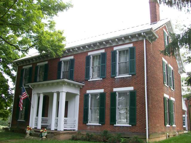
Photo: Bwsmith84, Wikimedia Commons, CC BY 3.0 · Wikimedia Commons
Local history sources: en.wikipedia.org · en.wikipedia.org · en.wikipedia.org · commons.wikimedia.org
Water
Mostly private wells The water here
- Belmont Public Water System56% of residentsGroundwater wells (2 wells)
- York Township Water Authority20% of residentsGroundwater wells (3 wells)
- Morristown Public Water System15% of residentsOhio River valley aquifer (wells)
- Shadyside Public Water System8% of residentsGroundwater wells (2 wells)
Hospitals, fire stations and more
Inside Smith Township, Belmont County's boundary: 1 fire or EMS station, 62 shale and injection wells and 5 spill cases. Press a pin or a name for its whole record and its source.
Fire and EMS stations (1)
-
Smith Township Volunteer Fire CompanyBelmont
- Address
- 46389 Firehouse Lane, Belmont, OH 43718
- Coordinates
- 39.97785, -80.96521
USGS National Map structures (source) ↗ Street map and directions ↗
Source: USGS National Map structures (most Ohio records last updated 2019 to 2022), checked against the Columbus and Cleveland station lists. The department that answers a call is set by jurisdiction and mutual aid, not by distance.
Shale and injection wells (62)
-
Bennington Unit 2HUtica shale well
- What it is
- Utica shale well
- Drilled sideways
- Yes
- Operator
- Ascent Resources Utica Llc
- County
- Belmont County
- API well number
- 34013210200000
- Coordinates
- 39.98210, -80.91444
ODNR oil and gas wells (source) ↗ Street map and directions ↗
The point is the surface well head (the pad); a horizontal well runs a mile or more underground from it.
-
Bennington Unit B 4HUtica shale well
- What it is
- Utica shale well
- Drilled sideways
- Yes
- Operator
- Ascent Resources Utica Llc
- County
- Belmont County
- API well number
- 34013210210000
- Coordinates
- 39.98214, -80.91442
ODNR oil and gas wells (source) ↗ Street map and directions ↗
The point is the surface well head (the pad); a horizontal well runs a mile or more underground from it.
-
Bigfoot 10Utica shale well
- What it is
- Utica shale well
- Drilled sideways
- Yes
- Operator
- Rice Drilling D Llc
- County
- Belmont County
- API well number
- 34013210670000
- Coordinates
- 40.02515, -80.97970
ODNR oil and gas wells (source) ↗ Street map and directions ↗
The point is the surface well head (the pad); a horizontal well runs a mile or more underground from it.
-
Bigfoot 2-AUtica shale well
- What it is
- Utica shale well
- Drilled sideways
- Yes
- Operator
- Rice Drilling D Llc
- County
- Belmont County
- API well number
- 34013211050000
- Coordinates
- 40.02489, -80.98000
ODNR oil and gas wells (source) ↗ Street map and directions ↗
The point is the surface well head (the pad); a horizontal well runs a mile or more underground from it.
-
Bigfoot 4Utica shale well
- What it is
- Utica shale well
- Drilled sideways
- Yes
- Operator
- Rice Drilling D Llc
- County
- Belmont County
- API well number
- 34013210690000
- Coordinates
- 40.02500, -80.97988
ODNR oil and gas wells (source) ↗ Street map and directions ↗
The point is the surface well head (the pad); a horizontal well runs a mile or more underground from it.
-
Bigfoot 6Utica shale well
- What it is
- Utica shale well
- Drilled sideways
- Yes
- Operator
- Rice Drilling D Llc
- County
- Belmont County
- API well number
- 34013210650000
- Coordinates
- 40.02505, -80.97983
ODNR oil and gas wells (source) ↗ Street map and directions ↗
The point is the surface well head (the pad); a horizontal well runs a mile or more underground from it.
-
Bigfoot 8Utica shale well
- What it is
- Utica shale well
- Drilled sideways
- Yes
- Operator
- Rice Drilling D Llc
- County
- Belmont County
- API well number
- 34013210680000
- Coordinates
- 40.02510, -80.97976
ODNR oil and gas wells (source) ↗ Street map and directions ↗
The point is the surface well head (the pad); a horizontal well runs a mile or more underground from it.
-
Bigfoot 9HUtica shale well
- What it is
- Utica shale well
- Drilled sideways
- Yes
- Operator
- Rice Drilling D Llc
- County
- Belmont County
- API well number
- 34013207150000
- Coordinates
- 40.02532, -80.97968
ODNR oil and gas wells (source) ↗ Street map and directions ↗
The point is the surface well head (the pad); a horizontal well runs a mile or more underground from it.
-
Blue Thunder 10HUtica shale well
- What it is
- Utica shale well
- Drilled sideways
- Yes
- Operator
- Rice Drilling D Llc
- County
- Belmont County
- API well number
- 34013207210000
- Coordinates
- 40.02453, -81.00377
ODNR oil and gas wells (source) ↗ Street map and directions ↗
The point is the surface well head (the pad); a horizontal well runs a mile or more underground from it.
-
Blue Thunder 12HUtica shale well
- What it is
- Utica shale well
- Drilled sideways
- Yes
- Operator
- Rice Drilling D Llc
- County
- Belmont County
- API well number
- 34013207220000
- Coordinates
- 40.02453, -81.00368
ODNR oil and gas wells (source) ↗ Street map and directions ↗
The point is the surface well head (the pad); a horizontal well runs a mile or more underground from it.
-
Blue Thunder 14Utica shale well
- What it is
- Utica shale well
- Drilled sideways
- Yes
- Operator
- Rice Drilling D Llc
- County
- Belmont County
- API well number
- 34013210710000
- Coordinates
- 40.02456, -81.00356
ODNR oil and gas wells (source) ↗ Street map and directions ↗
The point is the surface well head (the pad); a horizontal well runs a mile or more underground from it.
-
Blue Thunder 16Utica shale well
- What it is
- Utica shale well
- Drilled sideways
- Yes
- Operator
- Rice Drilling D Llc
- County
- Belmont County
- API well number
- 34013210700000
- Coordinates
- 40.02455, -81.00347
ODNR oil and gas wells (source) ↗ Street map and directions ↗
The point is the surface well head (the pad); a horizontal well runs a mile or more underground from it.
-
Dominator 1Utica shale well
- What it is
- Utica shale well
- Drilled sideways
- Yes
- Operator
- Rice Drilling D Llc
- County
- Belmont County
- API well number
- 34013211420000
- Coordinates
- 39.94203, -80.93153
ODNR oil and gas wells (source) ↗ Street map and directions ↗
The point is the surface well head (the pad); a horizontal well runs a mile or more underground from it.
-
Dominator 3Utica shale well
- What it is
- Utica shale well
- Drilled sideways
- Yes
- Operator
- Rice Drilling D Llc
- County
- Belmont County
- API well number
- 34013211430100
- Coordinates
- 39.94202, -80.93144
ODNR oil and gas wells (source) ↗ Street map and directions ↗
The point is the surface well head (the pad); a horizontal well runs a mile or more underground from it.
-
Dominator 5Utica shale well
- What it is
- Utica shale well
- Drilled sideways
- Yes
- Operator
- Rice Drilling D Llc
- County
- Belmont County
- API well number
- 34013211440000
- Coordinates
- 39.94201, -80.93135
ODNR oil and gas wells (source) ↗ Street map and directions ↗
The point is the surface well head (the pad); a horizontal well runs a mile or more underground from it.
-
Dominator 7Utica shale well
- What it is
- Utica shale well
- Drilled sideways
- Yes
- Operator
- Rice Drilling D Llc
- County
- Belmont County
- API well number
- 34013211450000
- Coordinates
- 39.94201, -80.93126
ODNR oil and gas wells (source) ↗ Street map and directions ↗
The point is the surface well head (the pad); a horizontal well runs a mile or more underground from it.
-
Dominator 9Utica shale well
- What it is
- Utica shale well
- Drilled sideways
- Yes
- Operator
- Rice Drilling D Llc
- County
- Belmont County
- API well number
- 34013211460000
- Coordinates
- 39.94200, -80.93117
ODNR oil and gas wells (source) ↗ Street map and directions ↗
The point is the surface well head (the pad); a horizontal well runs a mile or more underground from it.
-
Dornon 210033 1AUtica shale well
- What it is
- Utica shale well
- Drilled sideways
- Yes
- Operator
- Gulfport Appalachia Llc
- County
- Belmont County
- API well number
- 34013212890000
- Coordinates
- 39.94394, -80.95244
ODNR oil and gas wells (source) ↗ Street map and directions ↗
The point is the surface well head (the pad); a horizontal well runs a mile or more underground from it.
-
Dornon 210033 2BUtica shale well
- What it is
- Utica shale well
- Drilled sideways
- Yes
- Operator
- Gulfport Appalachia Llc
- County
- Belmont County
- API well number
- 34013212900000
- Coordinates
- 39.94397, -80.95247
ODNR oil and gas wells (source) ↗ Street map and directions ↗
The point is the surface well head (the pad); a horizontal well runs a mile or more underground from it.
-
Dornon 210642 3AUtica shale well
- What it is
- Utica shale well
- Drilled sideways
- Yes
- Operator
- Gulfport Appalachia Llc
- County
- Belmont County
- API well number
- 34013212870000
- Coordinates
- 39.94401, -80.95250
ODNR oil and gas wells (source) ↗ Street map and directions ↗
The point is the surface well head (the pad); a horizontal well runs a mile or more underground from it.
-
Dornon 210642 4BUtica shale well
- What it is
- Utica shale well
- Drilled sideways
- Yes
- Operator
- Gulfport Appalachia Llc
- County
- Belmont County
- API well number
- 34013212880000
- Coordinates
- 39.94404, -80.95253
ODNR oil and gas wells (source) ↗ Street map and directions ↗
The point is the surface well head (the pad); a horizontal well runs a mile or more underground from it.
-
Eureka Smt Bl 2H-AUtica shale well
- What it is
- Utica shale well
- Drilled sideways
- Yes
- Operator
- Ascent Resources Utica Llc
- County
- Belmont County
- API well number
- 34013208600000
- Coordinates
- 40.02004, -80.92791
ODNR oil and gas wells (source) ↗ Street map and directions ↗
The point is the surface well head (the pad); a horizontal well runs a mile or more underground from it.
-
Eureka Smt Bl 6H-AUtica shale well
- What it is
- Utica shale well
- Drilled sideways
- Yes
- Operator
- Ascent Resources Utica Llc
- County
- Belmont County
- API well number
- 34013208590000
- Coordinates
- 40.02007, -80.92784
ODNR oil and gas wells (source) ↗ Street map and directions ↗
The point is the surface well head (the pad); a horizontal well runs a mile or more underground from it.
-
Gold Digger 10Utica shale well
- What it is
- Utica shale well
- Drilled sideways
- Yes
- Operator
- Rice Drilling D Llc
- County
- Belmont County
- API well number
- 34013210720000
- Coordinates
- 40.01509, -80.94596
ODNR oil and gas wells (source) ↗ Street map and directions ↗
The point is the surface well head (the pad); a horizontal well runs a mile or more underground from it.
-
Gold Digger 1HUtica shale well
- What it is
- Utica shale well
- Drilled sideways
- Yes
- Operator
- Rice Drilling D Llc
- County
- Belmont County
- API well number
- 34013207460000
- Coordinates
- 40.01509, -80.94582
ODNR oil and gas wells (source) ↗ Street map and directions ↗
The point is the surface well head (the pad); a horizontal well runs a mile or more underground from it.
-
Gold Digger 2Utica shale well
- What it is
- Utica shale well
- Drilled sideways
- Yes
- Operator
- Rice Drilling D Llc
- County
- Belmont County
- API well number
- 34013210760000
- Coordinates
- 40.01499, -80.94629
ODNR oil and gas wells (source) ↗ Street map and directions ↗
The point is the surface well head (the pad); a horizontal well runs a mile or more underground from it.
-
Gold Digger 3HUtica shale well
- What it is
- Utica shale well
- Drilled sideways
- Yes
- Operator
- Rice Drilling D Llc
- County
- Belmont County
- API well number
- 34013207470000
- Coordinates
- 40.01512, -80.94574
ODNR oil and gas wells (source) ↗ Street map and directions ↗
The point is the surface well head (the pad); a horizontal well runs a mile or more underground from it.
-
Gold Digger 4Utica shale well
- What it is
- Utica shale well
- Drilled sideways
- Yes
- Operator
- Rice Drilling D Llc
- County
- Belmont County
- API well number
- 34013210750000
- Coordinates
- 40.01501, -80.94621
ODNR oil and gas wells (source) ↗ Street map and directions ↗
The point is the surface well head (the pad); a horizontal well runs a mile or more underground from it.
-
Gold Digger 6Utica shale well
- What it is
- Utica shale well
- Drilled sideways
- Yes
- Operator
- Rice Drilling D Llc
- County
- Belmont County
- API well number
- 34013210740000
- Coordinates
- 40.01504, -80.94612
ODNR oil and gas wells (source) ↗ Street map and directions ↗
The point is the surface well head (the pad); a horizontal well runs a mile or more underground from it.
-
Gold Digger 8Utica shale well
- What it is
- Utica shale well
- Drilled sideways
- Yes
- Operator
- Rice Drilling D Llc
- County
- Belmont County
- API well number
- 34013210730000
- Coordinates
- 40.01507, -80.94604
ODNR oil and gas wells (source) ↗ Street map and directions ↗
The point is the surface well head (the pad); a horizontal well runs a mile or more underground from it.
-
King Krunch 1Utica shale well
- What it is
- Utica shale well
- Drilled sideways
- Yes
- Operator
- Rice Drilling D Llc
- County
- Belmont County
- API well number
- 34013211970000
- Coordinates
- 39.95317, -80.92148
ODNR oil and gas wells (source) ↗ Street map and directions ↗
The point is the surface well head (the pad); a horizontal well runs a mile or more underground from it.
-
King Krunch 3Utica shale well
- What it is
- Utica shale well
- Drilled sideways
- Yes
- Operator
- Rice Drilling D Llc
- County
- Belmont County
- API well number
- 34013211960000
- Coordinates
- 39.95313, -80.92146
ODNR oil and gas wells (source) ↗ Street map and directions ↗
The point is the surface well head (the pad); a horizontal well runs a mile or more underground from it.
-
King Krunch 5Utica shale well
- What it is
- Utica shale well
- Drilled sideways
- Yes
- Operator
- Rice Drilling D Llc
- County
- Belmont County
- API well number
- 34013211980000
- Coordinates
- 39.95309, -80.92145
ODNR oil and gas wells (source) ↗ Street map and directions ↗
The point is the surface well head (the pad); a horizontal well runs a mile or more underground from it.
-
King Krunch 7Utica shale well
- What it is
- Utica shale well
- Drilled sideways
- Yes
- Operator
- Rice Drilling D Llc
- County
- Belmont County
- API well number
- 34013211950000
- Coordinates
- 39.95305, -80.92143
ODNR oil and gas wells (source) ↗ Street map and directions ↗
The point is the surface well head (the pad); a horizontal well runs a mile or more underground from it.
-
King Krunch 9Utica shale well
- What it is
- Utica shale well
- Drilled sideways
- Yes
- Operator
- Rice Drilling D Llc
- County
- Belmont County
- API well number
- 34013211940000
- Coordinates
- 39.95301, -80.92142
ODNR oil and gas wells (source) ↗ Street map and directions ↗
The point is the surface well head (the pad); a horizontal well runs a mile or more underground from it.
-
Mohawk Warrior 10HUtica shale well
- What it is
- Utica shale well
- Drilled sideways
- Yes
- Operator
- Rice Drilling D Llc
- County
- Belmont County
- API well number
- 34013207980000
- Coordinates
- 39.96688, -80.99874
ODNR oil and gas wells (source) ↗ Street map and directions ↗
The point is the surface well head (the pad); a horizontal well runs a mile or more underground from it.
-
Mohawk Warrior 12HUtica shale well
- What it is
- Utica shale well
- Drilled sideways
- Yes
- Operator
- Rice Drilling D Llc
- County
- Belmont County
- API well number
- 34013207970000
- Coordinates
- 39.96691, -80.99867
ODNR oil and gas wells (source) ↗ Street map and directions ↗
The point is the surface well head (the pad); a horizontal well runs a mile or more underground from it.
-
Mohawk Warrior 8HUtica shale well
- What it is
- Utica shale well
- Drilled sideways
- Yes
- Operator
- Rice Drilling D Llc
- County
- Belmont County
- API well number
- 34013207990000
- Coordinates
- 39.96684, -80.99882
ODNR oil and gas wells (source) ↗ Street map and directions ↗
The point is the surface well head (the pad); a horizontal well runs a mile or more underground from it.
-
Mohawk Warrior Asm4H1Utica shale well
- What it is
- Utica shale well
- Drilled sideways
- Yes
- Operator
- Rice Drilling D Llc
- County
- Belmont County
- API well number
- 34013214100000
- Coordinates
- 39.96696, -80.99875
ODNR oil and gas wells (source) ↗ Street map and directions ↗
The point is the surface well head (the pad); a horizontal well runs a mile or more underground from it.
-
Mohawk Warrior Asm4H3Utica shale well
- What it is
- Utica shale well
- Drilled sideways
- Yes
- Operator
- Rice Drilling D Llc
- County
- Belmont County
- API well number
- 34013214090000
- Coordinates
- 39.96699, -80.99868
ODNR oil and gas wells (source) ↗ Street map and directions ↗
The point is the surface well head (the pad); a horizontal well runs a mile or more underground from it.
-
Rammunition 10Utica shale well
- What it is
- Utica shale well
- Drilled sideways
- Yes
- Operator
- Rice Drilling D Llc
- County
- Belmont County
- API well number
- 34013211240000
- Coordinates
- 39.96945, -80.97008
ODNR oil and gas wells (source) ↗ Street map and directions ↗
The point is the surface well head (the pad); a horizontal well runs a mile or more underground from it.
-
Rammunition 1HUtica shale well
- What it is
- Utica shale well
- Drilled sideways
- Yes
- Operator
- Rice Drilling D Llc
- County
- Belmont County
- API well number
- 34013214690000
- Coordinates
- 39.96945, -80.97017
ODNR oil and gas wells (source) ↗ Street map and directions ↗
The point is the surface well head (the pad); a horizontal well runs a mile or more underground from it.
-
Rammunition 2Utica shale well
- What it is
- Utica shale well
- Drilled sideways
- Yes
- Operator
- Rice Drilling D Llc
- County
- Belmont County
- API well number
- 34013211270000
- Coordinates
- 39.96929, -80.97013
ODNR oil and gas wells (source) ↗ Street map and directions ↗
The point is the surface well head (the pad); a horizontal well runs a mile or more underground from it.
-
Rammunition 3HUtica shale well
- What it is
- Utica shale well
- Drilled sideways
- Yes
- Operator
- Rice Drilling D Llc
- County
- Belmont County
- API well number
- 34013214680000
- Coordinates
- 39.96949, -80.97016
ODNR oil and gas wells (source) ↗ Street map and directions ↗
The point is the surface well head (the pad); a horizontal well runs a mile or more underground from it.
-
Rammunition 4Utica shale well
- What it is
- Utica shale well
- Drilled sideways
- Yes
- Operator
- Rice Drilling D Llc
- County
- Belmont County
- API well number
- 34013211260000
- Coordinates
- 39.96933, -80.97012
ODNR oil and gas wells (source) ↗ Street map and directions ↗
The point is the surface well head (the pad); a horizontal well runs a mile or more underground from it.
-
Rammunition 6Utica shale well
- What it is
- Utica shale well
- Drilled sideways
- Yes
- Operator
- Rice Drilling D Llc
- County
- Belmont County
- API well number
- 34013211250000
- Coordinates
- 39.96937, -80.97010
ODNR oil and gas wells (source) ↗ Street map and directions ↗
The point is the surface well head (the pad); a horizontal well runs a mile or more underground from it.
-
Rammunition 8Utica shale well
- What it is
- Utica shale well
- Drilled sideways
- Yes
- Operator
- Rice Drilling D Llc
- County
- Belmont County
- API well number
- 34013211230000
- Coordinates
- 39.96949, -80.97007
ODNR oil and gas wells (source) ↗ Street map and directions ↗
The point is the surface well head (the pad); a horizontal well runs a mile or more underground from it.
-
Sergeant Smash 2Utica shale well
- What it is
- Utica shale well
- Drilled sideways
- Yes
- Operator
- Rice Drilling D Llc
- County
- Belmont County
- API well number
- 34013211360000
- Coordinates
- 39.96662, -80.98554
ODNR oil and gas wells (source) ↗ Street map and directions ↗
The point is the surface well head (the pad); a horizontal well runs a mile or more underground from it.
-
Sergeant Smash 4Utica shale well
- What it is
- Utica shale well
- Drilled sideways
- Yes
- Operator
- Rice Drilling D Llc
- County
- Belmont County
- API well number
- 34013211350000
- Coordinates
- 39.96662, -80.98545
ODNR oil and gas wells (source) ↗ Street map and directions ↗
The point is the surface well head (the pad); a horizontal well runs a mile or more underground from it.
-
Smith A 1H-12Utica shale well
- What it is
- Utica shale well
- Drilled sideways
- Yes
- Operator
- Ascent Resources Utica Llc
- County
- Belmont County
- API well number
- 34013207290000
- Coordinates
- 40.02015, -80.92766
ODNR oil and gas wells (source) ↗ Street map and directions ↗
The point is the surface well head (the pad); a horizontal well runs a mile or more underground from it.
-
Son-Uva Digger 1HUtica shale well
- What it is
- Utica shale well
- Drilled sideways
- Yes
- Operator
- Rice Drilling D Llc
- County
- Belmont County
- API well number
- 34013207790000
- Coordinates
- 40.01201, -80.95282
ODNR oil and gas wells (source) ↗ Street map and directions ↗
The point is the surface well head (the pad); a horizontal well runs a mile or more underground from it.
-
Son-Uva Digger 2Utica shale well
- What it is
- Utica shale well
- Drilled sideways
- Yes
- Operator
- Rice Drilling D Llc
- County
- Belmont County
- API well number
- 34013210770000
- Coordinates
- 40.01202, -80.95312
ODNR oil and gas wells (source) ↗ Street map and directions ↗
The point is the surface well head (the pad); a horizontal well runs a mile or more underground from it.
-
Son-Uva Digger 3HUtica shale well
- What it is
- Utica shale well
- Drilled sideways
- Yes
- Operator
- Rice Drilling D Llc
- County
- Belmont County
- API well number
- 34013207780000
- Coordinates
- 40.01201, -80.95273
ODNR oil and gas wells (source) ↗ Street map and directions ↗
The point is the surface well head (the pad); a horizontal well runs a mile or more underground from it.
-
Son-Uva Digger 4Utica shale well
- What it is
- Utica shale well
- Drilled sideways
- Yes
- Operator
- Rice Drilling D Llc
- County
- Belmont County
- API well number
- 34013210780000
- Coordinates
- 40.01202, -80.95303
ODNR oil and gas wells (source) ↗ Street map and directions ↗
The point is the surface well head (the pad); a horizontal well runs a mile or more underground from it.
-
Son-Uva Digger 5H-AUtica shale well
- What it is
- Utica shale well
- Drilled sideways
- Yes
- Operator
- Rice Drilling D Llc
- County
- Belmont County
- API well number
- 34013208700000
- Coordinates
- 40.01201, -80.95255
ODNR oil and gas wells (source) ↗ Street map and directions ↗
The point is the surface well head (the pad); a horizontal well runs a mile or more underground from it.
-
Son-Uva Digger 6Utica shale well
- What it is
- Utica shale well
- Drilled sideways
- Yes
- Operator
- Rice Drilling D Llc
- County
- Belmont County
- API well number
- 34013210790000
- Coordinates
- 40.01202, -80.95294
ODNR oil and gas wells (source) ↗ Street map and directions ↗
The point is the surface well head (the pad); a horizontal well runs a mile or more underground from it.
-
Thrasher 1HUtica shale well
- What it is
- Utica shale well
- Drilled sideways
- Yes
- Operator
- Rice Drilling D Llc
- County
- Belmont County
- API well number
- 34013209520000
- Coordinates
- 40.00674, -81.00316
ODNR oil and gas wells (source) ↗ Street map and directions ↗
The point is the surface well head (the pad); a horizontal well runs a mile or more underground from it.
-
Thrasher 3HUtica shale well
- What it is
- Utica shale well
- Drilled sideways
- Yes
- Operator
- Rice Drilling D Llc
- County
- Belmont County
- API well number
- 34013209560000
- Coordinates
- 40.00680, -81.00314
ODNR oil and gas wells (source) ↗ Street map and directions ↗
The point is the surface well head (the pad); a horizontal well runs a mile or more underground from it.
-
Thrasher 5HUtica shale well
- What it is
- Utica shale well
- Drilled sideways
- Yes
- Operator
- Rice Drilling D Llc
- County
- Belmont County
- API well number
- 34013209550000
- Coordinates
- 40.00687, -81.00312
ODNR oil and gas wells (source) ↗ Street map and directions ↗
The point is the surface well head (the pad); a horizontal well runs a mile or more underground from it.
-
Titan Asm16H1Utica shale well
- What it is
- Utica shale well
- Drilled sideways
- Yes
- Operator
- Rice Drilling D Llc
- County
- Belmont County
- API well number
- 34013214330000
- Coordinates
- 39.97666, -80.94453
ODNR oil and gas wells (source) ↗ Street map and directions ↗
The point is the surface well head (the pad); a horizontal well runs a mile or more underground from it.
-
Titan Asm16H11Utica shale well
- What it is
- Utica shale well
- Drilled sideways
- Yes
- Operator
- Rice Drilling D Llc
- County
- Belmont County
- API well number
- 34013214280000
- Coordinates
- 39.97662, -80.94438
ODNR oil and gas wells (source) ↗ Street map and directions ↗
The point is the surface well head (the pad); a horizontal well runs a mile or more underground from it.
-
Titan Asm16H5Utica shale well
- What it is
- Utica shale well
- Drilled sideways
- Yes
- Operator
- Rice Drilling D Llc
- County
- Belmont County
- API well number
- 34013214310000
- Coordinates
- 39.97665, -80.94442
ODNR oil and gas wells (source) ↗ Street map and directions ↗
The point is the surface well head (the pad); a horizontal well runs a mile or more underground from it.
Source: ODNR Division of Oil and Gas Resources well inventory (September 2026): drilled Utica, Marcellus and horizontal wells and Class II injection wells not plugged. Older vertical wells are on the full map.
Spills reported since 2021 (5)
-
Waste Water2025-11-02 · Smith Twp
- Reported
- 2025-11-02
- What spilled
- Waste Water
- Where
- Smith Twp, Belmont County
- Ohio EPA district office
- SEDO
- Ohio EPA case number
- 2511EPA0001785
Ohio EPA spill reports (source) ↗ Street map and directions ↗
-
Natural Gas2025-10-14 · Smith Twp
- Reported
- 2025-10-14
- What spilled
- Natural Gas
- Where
- Smith Twp, Carroll County
- Ohio EPA district office
- SEDO
- Ohio EPA case number
- 2510EPA0001705
Ohio EPA spill reports (source) ↗ Street map and directions ↗
-
Natural Gas2024-03-08 · Smith Twp
- Reported
- 2024-03-08
- What spilled
- Natural Gas
- Where
- Smith Twp, Belmont County
- Ohio EPA district office
- SEDO
- Ohio EPA case number
- 2403EPA0000370
Ohio EPA spill reports (source) ↗ Street map and directions ↗
-
Natural Gas2021-02-19 · Smith Twp
- Reported
- 2021-02-19
- What spilled
- Natural Gas
- Where
- Smith Twp, Belmont County
- Ohio EPA district office
- SEDO
- Ohio EPA case number
- 2102EPA0000218
Ohio EPA spill reports (source) ↗ Street map and directions ↗
-
Sediment / Sedimentation2026-03-24 · Null
- Reported
- 2026-03-24
- What spilled
- Sediment / Sedimentation
- Where
- Null, Belmont County
- Ohio EPA district office
- SEDO
- Ohio EPA case number
- 2603EPA0000470
Ohio EPA spill reports (source) ↗ Street map and directions ↗
Source: Ohio EPA emergency response spill reports, 2021 to September 2026, one point per case where Ohio EPA placed it. A report is what the caller or responder recorded; amounts are often blank or estimated.
Its ZIP codes
Each ZIP code that touches Smith Township, Belmont County, with the share of its residents who live here and the same headline figures as the ZIP page.
| ZIP | Share | Water | Radon | Home value | Schools | Flood |
|---|---|---|---|---|---|---|
| 43967 Smith Township and Warnock | 100% | Mostly private wells | Too few radon tests | Median year built 1935 | St. Clairsville-Richland City · 3.5 stars overall | 11% of residents in the 1% floodplain |
| 43933 Smith Township and Jacobsburg | 33% | Mostly private wells | 4.8 pCi/L average radon | Median year built 1977 | Union Local · 3 stars overall | 8.0% of residents in the 1% floodplain |
| 43718 Union Township and Belmont | 22% | Mostly private wells | 5.6 pCi/L average radon | Median year built 1980 | Union Local · 3 stars overall | 1.6% of residents in the 1% floodplain |
Local government
Who holds office in Smith Township, Belmont County, how its elections and ballot issues came out, and the state auditor's record.
Money issues on the ballot since 2017: 3 of 3 passed.
Ballot issues
| Date | Issue | For | Against | Result |
|---|---|---|---|---|
| 2017-11-07 | Issue: Smith Township Roads & Streets - Renewal Levy | 195 | 69 | Passed (73.86% for) |
| 2017-11-07 | Issue: Smith Township Community Center - Renewal Levy | 191 | 74 | Passed (72.08% for) |
| 2017-11-07 | Issue: Smith Township Fire - Renewal Levy | 211 | 54 | Passed (79.62% for) |
Elections for office
| Date | Office | Candidates and votes |
|---|---|---|
| 2021-11-02 | Township Trustee (unofficial count) | Michael B. DeLaney 172, 28.34%; Ronald W. Duvall 174, 28.67%; David A. Heath 141, 23.23%; Write-In: Hannah Baker 115, 18.95% |
| 2019-11-05 | Township Trustee | Write-In: James McGarry 44, 38.94% |
| 2019-11-05 | Township Fiscal Officer | Janette D. Carson 157, 100.0% |
| 2017-11-07 | Township Trustees | Ronald W. Duvall 194, 54.8%; Michael B. DeLaney 160, 45.2% |
| 2015-11-03 | Township Trustee | Stephen Randal Baker 325, 100.0% |
| 2015-11-03 | Township Fiscal Officer | Janette D. Carson 331, 100.0% |
Winners in bold. Results from the county board of elections' official canvass unless marked.
Auditor of State record
- No fiscal caution, watch or emergency on the Auditor of State's lists.
- Agreed Upon Procedures, 2023 to 2024, released 2025-11-06
The county
Belmont County: 23 ZIP codes, 29 cities, villages and townships, 64,982 people.
Nearby places
Quick answers
What county is Smith Township, Ohio in?
Smith Township, Belmont County is a township in Belmont County, Ohio, with 1,446 residents.
How did Smith Township, Ohio get its name?
Possibly named for William Smith, who built the township's first gristmill around 1805; the connection is stated as uncertain in the source consulted. Source
What ZIP code is Smith Township, Ohio?
Smith Township, Belmont County is served by ZIP codes 43967, 43933 and 43718; 43967 holds the largest share of its residents.
Where does Smith Township, Ohio get its water?
The main water source for Smith Township, Belmont County (Belmont Public Water System): Mostly private wells.
Cite this page
Cite this page as:
Cracked Buckeye, "Smith Township, Belmont County", https://crackedbuckeye.com/place/smith-township-belmont-county/, built 2026-10-31, accessed [date].
How to cite · Report a correction · Built 2026-10-31
