Local events in Woodsfield
Woodsfield itself has 4 events posted in the next 90 days; the others here are within 20 miles. All local events in Woodsfield
Checked October 20; the events page is refreshed daily.
History from Woodsfield
People and inventions tied to this place, each with its sources. All people · All inventions
How Woodsfield began
Woodsfield was laid out in 1815 to serve as the seat of the newly created Monroe County, on land connected to Archibald Woods, for whom it was named. The village grew up around the county courthouse and county-seat trades, was incorporated in 1835, and by the twentieth century held the county's bank, its churches and its central business district; its Main Street courthouse square still anchors five buildings on the National Register of Historic Places. Woodsfield's population peaked at 3,239 in 1970 and has since drifted down to about 2,210 as of the 2020 census, and it remains the county's largest village and the seat of the Switzerland of Ohio Local School District, the largest school district by land area in Ohio.
Settled 1812 (first settlement, per Center Township history), platted 1815, incorporated 1835, by connected to Archibald Woods, for whom the village was named.
Where the name comes from
Woodsfield was named for Archibald Woods.
Before the town
No source consulted names a Native American village, camp or mound specific to the town site of Woodsfield itself. The surrounding Sunfish Creek and Ohio River hill country that became Monroe County lay within land used by the Wyandot, Shawnee, Lenape (Delaware) and Mingo peoples before the Treaty of Greenville (1795), and Salem Township's local history records a Native name for Sunfish Creek ('Buckchitawa') and an 1801 killing near Sunfish Creek's mouth -- the nearest site-specific evidence found. Monroe County's wider Native history includes the Adena and Hopewell mound record and the treaties that opened this part of the county to settlement.
Nations recorded here: Wyandot, Shawnee, Lenape (Delaware), Mingo (Seneca-Cayuga).
Timeline
- — The Ohio General Assembly formed Monroe County from parts of Belmont, Guernsey and Washington counties.
- — Woodsfield was platted to become the seat of the new county.
- — The county commissioners let the contract for the first courthouse to James Carrothers.
- — A fire destroyed the county courthouse and the Probate Court's records.
- — A third courthouse was built at a cost of $40,000.
- — A Sanborn-style bird's-eye view map of Woodsfield was published by T. M. Fowler and James Moyer.
- — Woodsfield's population reached its recorded peak of 3,239.
- — A strike by Ormet Corporation employees affected Woodsfield's economic base.
Stories
Woodsfield's first burial
Levin Okey was one of the earliest and most prominent settlers of what became Center Township and the Woodsfield area, serving as a justice of the peace in Belmont County before Monroe County existed and later as a member of the first Board of Commissioners under Ohio's 1802 constitution. When his sister Sara died in 1812, she received what local histories record as the first documented burial in the yet-unplatted village of Woodsfield, attended by only seven mourners in a settlement still too small and too new to gather a crowd. Okey himself lived another seventeen years, long enough to see the county seat grow up around him; when he died on June 21, 1829, more than two hundred people came to his funeral, a measure of how quickly the raw courthouse town of 1812 had filled in with neighbors.
The courthouse that burned
Monroe County's first courthouse went up under contract to James Carrothers not long after Woodsfield was platted, and the first court convened there in 1820. It was replaced by a brick courthouse in 1828, and that building stood for nearly forty years until June 13, 1867, when a fire tore through it and destroyed not only the building but the county's Probate Court records -- an accident that erased an unknown quantity of the county's own written memory of its first half-century. The county rebuilt a third time, dedicating a $40,000 courthouse in 1868 that, enlarged and maintained since, is the Monroe County Courthouse standing on Woodsfield's Main Street today and listed on the National Register of Historic Places since 1980.
Photographs
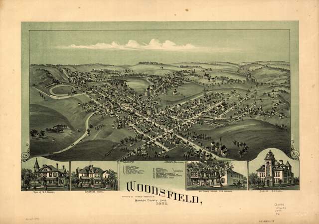
Photo: T. M. Fowler and James Moyer; Library of Congress, Geography & Map Division, public domain · Wikimedia Commons
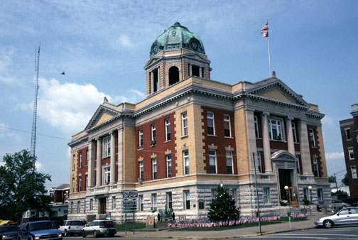
Photo: Calvin Beale, USDA, public domain · Wikimedia Commons
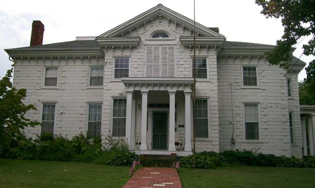
Photo: Bwsmith84, Wikimedia Commons, CC BY 3.0 · Wikimedia Commons
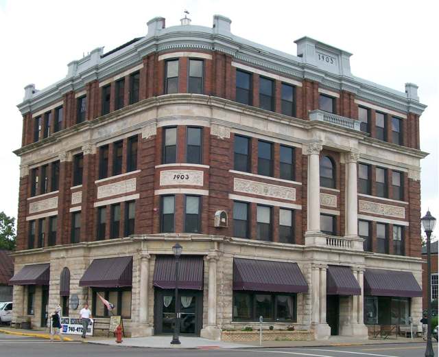
Photo: Bwsmith84, Wikimedia Commons, CC BY 3.0 · Wikimedia Commons
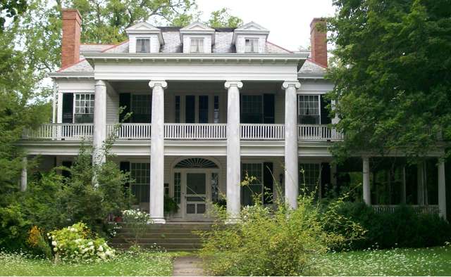
Photo: Bwsmith84, Wikimedia Commons, CC BY 3.0 · Wikimedia Commons
Local history sources: en.wikipedia.org · en.wikipedia.org · monroe.ohgenweb.org · monroe.ohgenweb.org · en.wikipedia.org · commons.wikimedia.org · commons.wikimedia.org · commons.wikimedia.org · commons.wikimedia.org · commons.wikimedia.org
Historic places
5 places in Woodsfield on the National Register of Historic Places. Press a pin or a name for its whole record.
-
First United Methodist ChurchBuilding · Woodsfield · listed 2006
- Address
- 136 N. Main St.
- Where
- Woodsfield, Monroe County · ZIP 43793
- What it is
- Building
- Listed on the National Register
- 2006
- NRIS reference number
- 06000694
- Coordinates
- 39.76372, -81.11487
National Register file (NPS) ↗ Search Wikipedia ↗ Street map and directions ↗ On the Cracked Buckeye map
-
Hollister-Parry HouseBuilding · Woodsfield · listed 1980
- Address
- 217 Eastern Ave.
- Where
- Woodsfield, Monroe County · ZIP 43793
- What it is
- Building
- Listed on the National Register
- 1980
- NRIS reference number
- 80003166
- Coordinates
- 39.76127, -81.11213
National Register file (NPS) ↗ Search Wikipedia ↗ Street map and directions ↗ On the Cracked Buckeye map
-
Monroe BankBuilding · Woodsfield · listed 1980
- Address
- 117 Main St.
- Where
- Woodsfield, Monroe County · ZIP 43793
- What it is
- Building
- Listed on the National Register
- 1980
- NRIS reference number
- 80003167
- Coordinates
- 39.76316, -81.11564
National Register file (NPS) ↗ Search Wikipedia ↗ Street map and directions ↗ On the Cracked Buckeye map
-
Monroe County CourthouseBuilding · Woodsfield · listed 1980
- Address
- Main St.
- Where
- Woodsfield, Monroe County · ZIP 43793
- What it is
- Building
- Listed on the National Register
- 1980
- NRIS reference number
- 80003168
- Coordinates
- 39.76298, -81.11634
National Register file (NPS) ↗ Search Wikipedia ↗ Street map and directions ↗ On the Cracked Buckeye map
-
Mooney, William C., HouseBuilding · Woodsfield · listed 1982
- Address
- 122 N. Paul St.
- Where
- Woodsfield, Monroe County · ZIP 43793
- What it is
- Building
- Listed on the National Register
- 1982
- NRIS reference number
- 82003615
- Coordinates
- 39.76407, -81.11261
National Register file (NPS) ↗ Search Wikipedia ↗ Street map and directions ↗ On the Cracked Buckeye map
Source: National Park Service, National Register of Historic Places point file. The listing year is shown where NPS's certification date agrees with the listing's reference number. Listing recognizes significance; it does not restrict a private owner.
Water
Mostly private wells The water here
- Woodsfield Village98% of residentsVillage-owned reservoirs (incl. Rubel Lake)
- Monroe Water Systems2% of residentsGroundwater wells (5 wells)
Hospitals, fire stations and more
Inside Woodsfield's boundary: 2 health centers, 1 nursing home, 1 fire or EMS station, 1 power plant, 2 public schools, 2 private schools, 1 library, 1 museum and 1 police station. Press a pin or a name for its whole record and its source.
Community health centers (2)
-
OHHC WoodsfieldHealth center · Woodsfield
- Run by
- a federally qualified health center
- Setting
- Clinic
- City
- Woodsfield
- Coordinates
- 39.76661, -81.12863
Find a Health Center (HRSA) ↗ HRSA data (source) ↗ Street map and directions ↗
-
Southeast, Inc. - Woodsfield Health CenterHealth center · Woodsfield
- Run by
- a federally qualified health center
- Setting
- Clinic
- City
- Woodsfield
- Coordinates
- 39.76541, -81.13119
Find a Health Center (HRSA) ↗ HRSA data (source) ↗ Street map and directions ↗
Source: HRSA health center service delivery sites, active, September 2026 (school-based sites left out). Health centers see patients whether or not they have insurance, with fees on a sliding scale.
Nursing homes (1)
-
Arbors at Woodsfield5 of 5 stars · Woodsfield
- Address
- 37930 Airport Road, Woodsfield, OH 43793
- Certified beds
- 85
- Residents on an average day
- 51
- Medicare overall rating
- 5 of 5 stars
- Health inspections
- 4 of 5 stars
- Staffing
- 4 of 5 stars
- Quality measures
- 5 of 5 stars
- Penalties since 2023
- none
- Ownership
- For profit - Limited Liability company
- Chain
- ARBORS AT OHIO
- Takes
- Medicare and Medicaid
- Phone
- (740) 472-1678
- Medicare ID
- 365496
Medicare Care Compare ↗ CMS nursing home data (source) ↗ Street map and directions ↗
Source: CMS Care Compare nursing home provider and penalties files; Medicare star ratings run 1 to 5.
Fire and EMS stations (1)
-
Woodsfield Volunteer Fire DepartmentWoodsfield
- Address
- 38000 Old Airport Road, Woodsfield, OH 43793
- Coordinates
- 39.76443, -81.12979
USGS National Map structures (source) ↗ Street map and directions ↗
Source: USGS National Map structures (most Ohio records last updated 2019 to 2022), checked against the Columbus and Cleveland station lists. The department that answers a call is set by jurisdiction and mutual aid, not by distance.
Power plants (1)
-
AnadarkoPetroleum · 8 MW
- Capacity
- 8 MW
- Main source
- Petroleum
- Technology
- Petroleum Liquids
- Operator
- City of Woodsfield - (OH)
- Sector
- Electric Utility
- Where
- Woodsfield, Monroe County
- Generating units
- 6
- Built
- 1949 (first unit); newest unit 1983
- EIA plant code
- 2945
EIA plant page ↗ EIA-860 (source) ↗ Street map and directions ↗
Source: EIA-860 power plant inventory via HIFLD (February 2025), with plant codes, units and years from EIA-860 2025.
Public schools (2)
-
Monroe Central High School2.5 of 5 stars · Woodsfield
- Address
- 469 Lewisville Rd, Woodsfield, OH 43793
- School district
- Switzerland of Ohio Local School District
- Kind (NCES)
- Regular School
- Students, 2023-24
- 241
- Teachers (full-time equivalent)
- 21.8
- Report card, 2025-26
- 2.5 of 5 stars
- Performance index
- 73.6%
- Four-year graduation rate
- 86.7%
- Ohio building IRN
- 042085
- NCES school ID
- 390486503340
NCES school record ↗ Ohio School Report Card ↗ Street map and directions ↗
-
Woodsfield Elementary School3.5 of 5 stars · Woodsfield
- Address
- 473 Lewisville Rd, Woodsfield, OH 43793
- School district
- Switzerland of Ohio Local School District
- Kind (NCES)
- Regular School
- Students, 2023-24
- 377
- Teachers (full-time equivalent)
- 28.3
- Report card, 2025-26
- 3.5 of 5 stars
- Performance index
- 75.8%
- Ohio building IRN
- 042077
- NCES school ID
- 390486503339
NCES school record ↗ Ohio School Report Card ↗ Street map and directions ↗
Source: NCES EDGE public school locations 2024-25 and Common Core of Data 2023-24 (type, students, teachers); Ohio School Report Cards 2025-26 (Department of Education and Workforce), matched by name within the district.
Private schools (2)
-
Covenant Christian AcademyPrivate, religious, independent · Woodsfield
- Address
- 185 Shady Ave, Woodsfield, OH 43793
- Kind
- religious, independent
- Students, 2023-24
- 32
- Teachers (full-time equivalent)
- 5
- Students per teacher
- 6.4
- Phone
- (740) 472-5693
- NCES private school ID
- BB182126
-
St Sylvester Central SchoolPrivate, Catholic · Woodsfield
- Address
- 119 Wayne St, Woodsfield, OH 43793
- Kind
- Catholic
- Students, 2023-24
- 64
- Teachers (full-time equivalent)
- 8.3
- Students per teacher
- 7.71084
- Phone
- (740) 472-0321
- NCES private school ID
- 01060364
Source: NCES Private School Survey 2023-24.
Public libraries (1)
-
Monroe County District LibraryCentral library · Woodsfield
- Address
- 96 Home Ave., Woodsfield, OH 43793
- What it is
- Central library
- Library system
- Monroe County District Library
- Open
- 2,132 hours a year, 52 weeks
- Building
- 11,100 sq ft
- System's visits, FY2024
- 26,260
- System's loans, FY2024
- 80,579
- People the system serves
- 13,385
- Phone
- (740) 472-1954
IMLS Public Libraries Survey (source) ↗ Street map and directions ↗
Source: IMLS Public Libraries Survey FY2024 (outlets and their systems). Any Ohio resident can get a free card at any Ohio public library.
Museums, historical societies, gardens and zoos (1)
-
Monroe County Historical SocietyHistorical society · Woodsfield
- What it is
- Historical society
- City
- Woodsfield
- Coordinates
- 39.75981, -81.10899
Search Wikipedia ↗ IMLS Museum Data Files (source) ↗ Street map and directions ↗
The museum list is IMLS's 2018 file; a museum may have closed or moved since.
Source: IMLS Museum Data Files, 2018.
Police stations (1)
-
Woodsfield Municipal Police DepartmentWoodsfield
- Address
- 221 South Main Street, Woodsfield, OH 43793
- Coordinates
- 39.76062, -81.11749
USGS National Map structures (source) ↗ Street map and directions ↗
Source: USGS National Map structures, police stations, corrected and completed by hand (September 2026). The department that answers a call is set by jurisdiction, not by distance.
Its ZIP codes
Each ZIP code that touches Woodsfield, with the share of its residents who live here and the same headline figures as the ZIP page.
| ZIP | Share | Water | Radon | Home value | Schools | Flood |
|---|---|---|---|---|---|---|
| 43793 Woodsfield | 46% | Mostly private wells | 4.5 pCi/L average radon | Median year built 1957 | Switzerland of Ohio Local · 3 stars overall | 0.7% of residents in the 1% floodplain |
Local government
Who holds office in Woodsfield, how its elections and ballot issues came out, and the state auditor's record.
Elections for office
| Date | Office | Candidates and votes |
|---|---|---|
| 2019-11-05 | Mayor | Carol Hehr 170, 30.2%; Michael E. Ricer 393, 69.8% |
Winners in bold. Results from the county board of elections' official canvass unless marked.
Auditor of State record
- No fiscal caution, watch or emergency on the Auditor of State's lists.
- Special Audit, 2015 to 2023, released 2026-08-20
- Financial Audit, 2023 to 2024, released 2026-01-08
The county
Monroe County: 10 ZIP codes, 27 cities, villages and townships, 13,100 people.
Nearby places
Rain and snow
How much has actually fallen on Woodsfield, day by day, from 1889 to now. Daily totals, not averages.
- rain, last 30 days
- 2.68 in
- 2026-09-30 to 2026-10-29
- rain so far in 2026
- 46.5 in
- 3.5 in above normal for the date
- snow so far in 2026
- 20.2 in
- a normal year brings 26.9 in
- a normal year
- 50.5 in
- average of 30 years, 1991-2020
| Month | Rain (in) | Snow (in) | Days counted |
|---|---|---|---|
| October 2026 | 2.68 | — | 29 |
| September 2026 | 5.74 | — | 30 |
| August 2026 | 8.06 | — | 31 |
| July 2026 | 4.87 | — | 31 |
| June 2026 | 5.18 | — | 30 |
| May 2026 | 6.38 | — | 31 |
| April 2026 | 3.76 | — | 30 |
| March 2026 | 6.40 | 3.9 | 31 |
| February 2026 | 1.11 | 3.7 | 28 |
| January 2026 | 2.30 | 12.6 | 31 |
| December 2025 | 2.23 | 8.8 | 31 |
| November 2025 | 2.39 | 0.2 | 30 |
| Wettest year | 2003 — 80.1 in |
|---|---|
| Driest year | 1930 — 24.5 in |
| Snowiest year | 2003 — 81.0 in |
| Wettest day on record | 17 September 2004 — 6.07 in |
| Heaviest snowfall in a day | 16 February 2003 — 21.46 in |
| Deepest snow on the ground | 18 February 2003 — 19.82 in |
Estimated, not measured. No rain gauge has ever stood inside Woodsfield, so every figure here is worked out from the gauges around it - the nearest ones weighted most. Treat them as close estimates rather than readings.
49,959 days of records, 1889-09-01 to 2026-10-29. Source: NOAA NCEI GHCN-Daily, 3,240 gauges in and around Ohio. A day is "gauged" when a gauge standing inside the boundary reported it, and the value is the mean of those gauges. Otherwise it is interpolated by inverse distance from every gauge reporting within 50 miles. Nothing is carried forward, back-filled or smoothed. Against NOAA nClimDiv county monthly precipitation over 136,848 complete county-months (checked 2026-10-31): correlation 0.9515, median absolute difference 0.217 in a month. Built 2026-10-31 from the Cracked Buckeye precipitation archive. Snow is the softer number — snowfall is measured by hand with a ruler, no agency publishes a gridded county snowfall series, and blowing snow defeats every observer.
Environmental permits and filings
What Ohio EPA has on file for Woodsfield: permits, inspections, violations, cleanups and the state loans behind sewer and water work. Every line links to the agency's own document.
- facilities and sites on file
- 9
- those placed on the map inside Woodsfield
| Program | Facilities and sites |
|---|---|
| Air pollution | 2 |
| Hazardous waste | 2 |
| State sewer loans | 2 |
| Sewer and water-line construction | 1 |
| State water loans | 1 |
| Wastewater and stormwater discharge | 1 |
Source: Ohio EPA eDocument portal (edocpub.epa.ohio.gov), indexed 2026-10-14. Facilities are placed on the map from Ohio EPA's own map layers, EPA's Facility Registry, coordinates written in the filings, or a geocoded street address. A permit filed under a private person's name (most are household septic systems) is counted but never named, placed or linked; licenses for individual workers and open-burning notices are left out entirely.
Quick answers
What county is Woodsfield, Ohio in?
Woodsfield is a village in Monroe County, Ohio, with 2,218 residents.
When was Woodsfield, Ohio founded?
Woodsfield was settled 1812 (first settlement, per Center Township history); laid out 1815; incorporated 1835. Founders on record: connected to Archibald Woods, for whom the village was named. Source
How did Woodsfield, Ohio get its name?
Woodsfield was named for Archibald Woods. Source
What ZIP code is Woodsfield, Ohio?
Most of Woodsfield is in ZIP code 43793.
Where does Woodsfield, Ohio get its water?
The main water source for Woodsfield (Woodsfield Village): Mostly private wells.
Cite this page
Cite this page as:
Cracked Buckeye, "Woodsfield, Monroe County", https://crackedbuckeye.com/place/woodsfield/, built 2026-10-31, accessed [date].
How to cite · Report a correction · Built 2026-10-31
