Local events in Perry Township, Monroe County
Nothing is posted yet for this township in the calendars we watch. What we watch, and what is on nearby
Know a calendar we should watch? Send the link
Checked October 20; the events page is refreshed daily.
How Perry Township, Monroe County began
Perry Township, organized December 30, 1823, saw its first cabin go up in 1800, built by Jesse Fleming, though permanent settlement waited until 1812, when Daniel Dye Sr. and his sons founded what became known as Dye's Settlement near the future village of Antioch. Antioch itself was organized in 1837 by William Jarvis and had grown into a substantial village by 1881, with stores, blacksmith shops and hotels; nearby Mechanicsburg developed around coal banks in 1882. The Foraker Bridge, a National Register-listed structure, stands in the township.
Settled 1800 (first cabin, Jesse Fleming); 1812 (Dye's Settlement, permanent), incorporated 1823-12-30 (township organized).
Where the name comes from
No source consulted explains the origin of the township name 'Perry.'
Before the town
The Perry Township local history names Henry Johnson, the township's first schoolteacher at Dye's Settlement beginning in 1824, as a survivor of 'the adventure with the Indians in early Monroe county history,' with no further detail. Henry Johnson's own account, given to a Woodsfield paper about 1835-40 and recorded by the traveling historian Henry Howe, supplies that detail: in the fall of 1788, Johnson (then about eleven) and his older brother John were taken captive near Beech Bottom on the Ohio River, marched inland, and escaped after killing both of their captors with the men's own gun and tomahawk while they slept, reaching Carpenter's Fort before daybreak. The capture took place well upriver of the township, in present West Virginia, before Johnson later settled in Monroe County; no mound, earthwork or named Native village site within Perry Township itself was reported by any source consulted.
Nations recorded here: Wyandot, Shawnee, Lenape (Delaware), Mingo (Seneca-Cayuga).
- Site of Henry and John Johnson's 1788 captivity and escape (other) — near Beech Bottom, Ohio River (present West Virginia); Henry Johnson later settled in Monroe County and taught Perry Township's first school, 1788 (archive.org)
Timeline
- — Jesse Fleming built the township's first cabin, though permanent settlement did not follow immediately.
- — Daniel Dye Sr. and his sons settled what became known as Dye's Settlement, near the future village of Antioch.
- — Perry Township was formally organized.
- — Henry Johnson taught the township's first school, at Dye's Settlement; the first township election, held that spring on George Foraker's farm, elected Peter Hought as first trustee.
- — Thomas Mitchell built a water mill and sawmill on Witten Fork.
- — William Jarvis organized the village of Antioch.
- — Antioch had grown to 210 residents with three general stores, two blacksmith shops and two hotels.
- — Mechanicsburg developed around the township's coal banks.
- — Henry Johnson, about eleven, and his older brother John were taken captive near Beech Bottom on the Ohio River; the boys killed both captors in their sleep and escaped to Carpenter's Fort, an episode Perry Township's local history remembers only as Johnson's unexplained 'adventure with the Indians.'
- — Henry Johnson, the 1788 captivity's survivor and Perry Township's first schoolteacher, was elected the first Mayor of Woodsfield following the town's 1834 incorporation.
- — Henry Johnson died at Antioch, in the township he had helped settle, and was buried at Woodsfield.
- — The Foraker Bridge (also spelled Foreaker, and also called the Weddle Covered Bridge), on Monroe County Road 40 three miles east of Graysville, was listed on the National Register of Historic Places.
Stories
Dye's Settlement, and the preacher who founded it
Daniel Dye Sr. arrived in what became Perry Township in 1812 with his sons, founding the cluster of farms that local memory still called 'Dye's Settlement' decades later, even after the village of Antioch grew up nearby and took over as the community's center. Dye was a Baptist minister as well as a settler, and he conducted the township's first recorded sermon at his own home -- pairing, as so often happened on the Ohio frontier, the roles of pioneer farmer and pastor in the same person. The settlement he founded gave its name to the area for a generation before Antioch, organized by William Jarvis in 1837, absorbed its identity; by 1881 Antioch had three stores, two blacksmith shops and two hotels, evidence of how quickly an organized village could outgrow the informal settlement that preceded it.
The Johnson boys' escape
In the fall of 1788, Henry Johnson was about eleven years old and his brother John about thirteen when the two were taken captive near Beech Bottom on the Ohio River and marched inland by two Native men. The boys played along, telling their captors deliberately wrong directions home to seem harmlessly lost, and waited out a tense night in camp. When both men finally fell asleep by the fire, John seized the gun one of them had used to strike a light while Henry took up a tomahawk; together they killed both captors and fled before daybreak to the safety of Carpenter's Fort. Henry Johnson carried that night with him through a long life in Monroe County: he taught Perry Township's first school at Dye's Settlement beginning in 1824, was elected Woodsfield's first mayor in 1836, and died at Antioch in 1850. Locally he was remembered only for having had 'the adventure with the Indians' -- a phrase that would have kept its details lost if Johnson had not given a fuller account of that night to a Woodsfield newspaper decades later, an account the traveling historian Henry Howe preserved in print.
Photographs
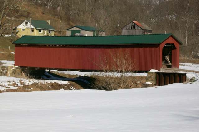
Photo: Bwsmith84, via Wikimedia Commons, CC BY 3.0 · Wikimedia Commons
Local history sources: monroe.ohgenweb.org · en.wikipedia.org · archive.org · archive.org · archive.org · en.wikipedia.org · en.wikipedia.org · commons.wikimedia.org
Historic places
1 place in Perry Township, Monroe County on the National Register of Historic Places. Press a pin or a name for its whole record.
-
Foreaker BridgeStructure · Graysville · listed 1975
- Address
- 3 mi. E of Graysville on SR 40
- Where
- Graysville, Monroe County · ZIP 43793
- What it is
- Structure
- Listed on the National Register
- 1975
- NRIS reference number
- 75001493
- Coordinates
- 39.65557, -81.12082
National Register file (NPS) ↗ Search Wikipedia ↗ Street map and directions ↗ On the Cracked Buckeye map
Source: National Park Service, National Register of Historic Places point file. The listing year is shown where NPS's certification date agrees with the listing's reference number. Listing recognizes significance; it does not restrict a private owner.
Water
Mostly private wells The water here
- Woodsfield Village56% of residentsVillage-owned reservoirs (incl. Rubel Lake)
- Ohio and Lee Twp Water Authority39% of residentsGroundwater wells (2 wells)
- Matamoras Village4% of residentsGroundwater wells (2 wells)
- Monroe Water Systems1% of residentsGroundwater wells (5 wells)
Hospitals, fire stations and more
Inside Perry Township, Monroe County's boundary: 1 poor-rated bridge and 17 shale and injection wells. Press a pin or a name for its whole record and its source.
Bridges rated poor (1)
-
Twp Rd 1004 over Little Muskingum RiverPoor · built 1900
- Condition
- Poor: a deck, superstructure, substructure or culvert rated 4 or below on the 0 to 9 scale
- What it is
- Bridge
- Built
- 1900
- Length
- 34 ft
- Owner
- County
- Vehicles a day
- 96
- Coordinates
- 39.64605, -81.08359
National Bridge Inventory (source) ↗ Street map and directions ↗
Source: FHWA National Bridge Inventory 2025. "Poor" means one major part rated 4 or below on the 0 to 9 scale; it calls for repair, not closing, unless the state posts or closes the bridge.
Shale and injection wells (17)
-
Moonraker 1-PphUtica shale well
- What it is
- Utica shale well
- Drilled sideways
- Yes
- Operator
- Diversified Production Llc
- County
- Monroe County
- API well number
- 34111248420000
- Coordinates
- 39.67282, -81.08561
ODNR oil and gas wells (source) ↗ Street map and directions ↗
The point is the surface well head (the pad); a horizontal well runs a mile or more underground from it.
-
Moonraker 2-PphUtica shale well
- What it is
- Utica shale well
- Drilled sideways
- Yes
- Operator
- Diversified Production Llc
- County
- Monroe County
- API well number
- 34111244710100
- Coordinates
- 39.67289, -81.08521
ODNR oil and gas wells (source) ↗ Street map and directions ↗
The point is the surface well head (the pad); a horizontal well runs a mile or more underground from it.
-
Moonraker 3-PphUtica shale well
- What it is
- Utica shale well
- Drilled sideways
- Yes
- Operator
- Diversified Production Llc
- County
- Monroe County
- API well number
- 34111248430000
- Coordinates
- 39.67278, -81.08559
ODNR oil and gas wells (source) ↗ Street map and directions ↗
The point is the surface well head (the pad); a horizontal well runs a mile or more underground from it.
-
Nick Nack 1UhUtica shale well
- What it is
- Utica shale well
- Drilled sideways
- Yes
- Operator
- Diversified Production Llc
- County
- Monroe County
- API well number
- 34111249700000
- Coordinates
- 39.64819, -81.05097
ODNR oil and gas wells (source) ↗ Street map and directions ↗
The point is the surface well head (the pad); a horizontal well runs a mile or more underground from it.
-
Nick Nack 2-PphUtica shale well
- What it is
- Utica shale well
- Drilled sideways
- Yes
- Operator
- Diversified Production Llc
- County
- Monroe County
- API well number
- 34111246950000
- Coordinates
- 39.64813, -81.05117
ODNR oil and gas wells (source) ↗ Street map and directions ↗
The point is the surface well head (the pad); a horizontal well runs a mile or more underground from it.
-
Nick Nack 3UhUtica shale well
- What it is
- Utica shale well
- Drilled sideways
- Yes
- Operator
- Diversified Production Llc
- County
- Monroe County
- API well number
- 34111249710000
- Coordinates
- 39.64816, -81.05107
ODNR oil and gas wells (source) ↗ Street map and directions ↗
The point is the surface well head (the pad); a horizontal well runs a mile or more underground from it.
-
Nick Nack 4-PphUtica shale well
- What it is
- Utica shale well
- Drilled sideways
- Yes
- Operator
- Diversified Production Llc
- County
- Monroe County
- API well number
- 34111246550000
- Coordinates
- 39.64820, -81.05121
ODNR oil and gas wells (source) ↗ Street map and directions ↗
The point is the surface well head (the pad); a horizontal well runs a mile or more underground from it.
-
Odd Job 10-PphUtica shale well
- What it is
- Utica shale well
- Drilled sideways
- Yes
- Operator
- Diversified Production Llc
- County
- Monroe County
- API well number
- 34111246450000
- Coordinates
- 39.68383, -81.06995
ODNR oil and gas wells (source) ↗ Street map and directions ↗
The point is the surface well head (the pad); a horizontal well runs a mile or more underground from it.
-
Odd Job 4-PphUtica shale well
- What it is
- Utica shale well
- Drilled sideways
- Yes
- Operator
- Diversified Production Llc
- County
- Monroe County
- API well number
- 34111246180000
- Coordinates
- 39.68369, -81.06985
ODNR oil and gas wells (source) ↗ Street map and directions ↗
The point is the surface well head (the pad); a horizontal well runs a mile or more underground from it.
-
Valenka 2 2-PphUtica shale well
- What it is
- Utica shale well
- Drilled sideways
- Yes
- Operator
- Diversified Production Llc
- County
- Monroe County
- API well number
- 34111247420000
- Coordinates
- 39.67658, -81.09842
ODNR oil and gas wells (source) ↗ Street map and directions ↗
The point is the surface well head (the pad); a horizontal well runs a mile or more underground from it.
-
Valenka 2 4-PphUtica shale well
- What it is
- Utica shale well
- Drilled sideways
- Yes
- Operator
- Diversified Production Llc
- County
- Monroe County
- API well number
- 34111247410000
- Coordinates
- 39.67655, -81.09832
ODNR oil and gas wells (source) ↗ Street map and directions ↗
The point is the surface well head (the pad); a horizontal well runs a mile or more underground from it.
-
Valenka 2 4-PphUtica shale well · Drilling
- What it is
- Utica shale well
- Drilled sideways
- Yes
- Status (ODNR)
- Drilling
- Operator
- Diversified Production Llc
- County
- Monroe County
- API well number
- 34111247430000
- Coordinates
- 39.67657, -81.09837
ODNR oil and gas wells (source) ↗ Street map and directions ↗
The point is the surface well head (the pad); a horizontal well runs a mile or more underground from it.
-
Valenka 2 6-PphUtica shale well
- What it is
- Utica shale well
- Drilled sideways
- Yes
- Operator
- Diversified Production Llc
- County
- Monroe County
- API well number
- 34111247400000
- Coordinates
- 39.67653, -81.09828
ODNR oil and gas wells (source) ↗ Street map and directions ↗
The point is the surface well head (the pad); a horizontal well runs a mile or more underground from it.
-
Zorin 2A-PphUtica shale well
- What it is
- Utica shale well
- Drilled sideways
- Yes
- Operator
- Diversified Production Llc
- County
- Monroe County
- API well number
- 34111248010000
- Coordinates
- 39.68235, -81.08395
ODNR oil and gas wells (source) ↗ Street map and directions ↗
The point is the surface well head (the pad); a horizontal well runs a mile or more underground from it.
-
Zorin 4-PphUtica shale well
- What it is
- Utica shale well
- Drilled sideways
- Yes
- Operator
- Diversified Production Llc
- County
- Monroe County
- API well number
- 34111247560000
- Coordinates
- 39.68239, -81.08393
ODNR oil and gas wells (source) ↗ Street map and directions ↗
The point is the surface well head (the pad); a horizontal well runs a mile or more underground from it.
-
Zorin 6-PphUtica shale well
- What it is
- Utica shale well
- Drilled sideways
- Yes
- Operator
- Diversified Production Llc
- County
- Monroe County
- API well number
- 34111247570000
- Coordinates
- 39.68243, -81.08391
ODNR oil and gas wells (source) ↗ Street map and directions ↗
The point is the surface well head (the pad); a horizontal well runs a mile or more underground from it.
-
Zorin 8-PphUtica shale well
- What it is
- Utica shale well
- Drilled sideways
- Yes
- Operator
- Diversified Production Llc
- County
- Monroe County
- API well number
- 34111247540000
- Coordinates
- 39.68246, -81.08389
ODNR oil and gas wells (source) ↗ Street map and directions ↗
The point is the surface well head (the pad); a horizontal well runs a mile or more underground from it.
Source: ODNR Division of Oil and Gas Resources well inventory (September 2026): drilled Utica, Marcellus and horizontal wells and Class II injection wells not plugged. Older vertical wells are on the full map.
Its ZIP codes
Each ZIP code that touches Perry Township, Monroe County, with the share of its residents who live here and the same headline figures as the ZIP page.
| ZIP | Share | Water | Radon | Home value | Schools | Flood |
|---|---|---|---|---|---|---|
| 43946 Lee Township and Sardis | 10% | Mostly private wells | Too few radon tests | Median year built 1967 | Switzerland of Ohio Local · 3 stars overall | 14% of residents in the 1% floodplain |
| 43793 Woodsfield | 3% | Mostly private wells | 4.5 pCi/L average radon | Median year built 1957 | Switzerland of Ohio Local · 3 stars overall | 0.7% of residents in the 1% floodplain |
| 45767 Grandview Township and New Matamoras | 1% | Mostly private wells | 4.8 pCi/L average radon | Median year built 1960 | Frontier Local · 3 stars overall | 9.7% of residents in the 1% floodplain |
Local government
Who holds office in Perry Township, Monroe County, how its elections and ballot issues came out, and the state auditor's record.
Money issues on the ballot since 2020: 2 of 2 passed.
Ballot issues
| Date | Issue | For | Against | Result |
|---|---|---|---|---|
| 2024-11-05 | Issue: Perry Township Tax Levy Fire | 158 | 42 | Passed (79.0% for) |
| 2020-03-17 | Issue: Perry Twp Tax Levy Fire | 63 | 12 | Passed (84.0% for) |
Elections for office
| Date | Office | Candidates and votes |
|---|---|---|
| 2021-11-02 | Township Trustee | David F. Price 44, 57.14%; Ronald Vernon 33, 42.86% |
| 2019-11-05 | Township Trustee | Michael Brown 55, 100.0% |
Winners in bold. Results from the county board of elections' official canvass unless marked.
Auditor of State record
- No fiscal caution, watch or emergency on the Auditor of State's lists.
- Basic Audit, 2023 to 2024, released 2025-07-08
The county
Monroe County: 10 ZIP codes, 27 cities, villages and townships, 13,100 people.
Nearby places
Quick answers
What county is Perry Township, Ohio in?
Perry Township, Monroe County is a township in Monroe County, Ohio, with 361 residents.
When was Perry Township, Ohio founded?
Perry Township, Monroe County was settled 1800 (first cabin, Jesse Fleming); 1812 (Dye's Settlement, permanent); incorporated 1823-12-30 (township organized). Source
What ZIP code is Perry Township, Ohio?
Perry Township, Monroe County is served by ZIP codes 43946 and 43793; 43946 holds the largest share of its residents.
Where does Perry Township, Ohio get its water?
The main water source for Perry Township, Monroe County (Woodsfield Village): Mostly private wells.
Cite this page
Cite this page as:
Cracked Buckeye, "Perry Township, Monroe County", https://crackedbuckeye.com/place/perry-township-monroe-county/, built 2026-10-31, accessed [date].
How to cite · Report a correction · Built 2026-10-31