Local events in Washington Township, Monroe County
Nothing is posted for Washington Township itself yet; here is what is on within 20 miles. All local events in Washington Township, Monroe County
Know a calendar we should watch? Send the link
Checked October 20; the events page is refreshed daily.
How Washington Township, Monroe County began
Washington Township, formally organized June 5, 1832, was actually settled decades earlier, in 1804, when Isaac Brown and the brothers Joseph and William Cline built the township's first cabins along Clear Fork -- the same Cline family whose descendants also appear among the earliest settlers of neighboring Benton Township. The township's Knowlton Covered Bridge is listed on the National Register of Historic Places, and its village of Graysville grew up to support four churches by 1849. Mills built and rebuilt after fires marked the township's early industrial history, including a grist mill destroyed by fire in 1816 and rebuilt soon after.
Settled 1804 (Isaac Brown, Joseph and William Cline), incorporated 1832-06-05 (township organized).
Where the name comes from
No source consulted explains the origin of the township name 'Washington' beyond its evident reference to the first U.S. president, a common township name across Ohio.
Before the town
No source consulted names a Native American village, camp or mound specific to Washington Township. The area lay within the broader hunting and travel range of the Wyandot, Shawnee, Lenape (Delaware) and Mingo peoples before the Treaty of Greenville (1795), but no source found ties a named site to the township.
Nations recorded here: Wyandot, Shawnee, Lenape (Delaware), Mingo (Seneca-Cayuga).
Timeline
- — Isaac Brown and brothers Joseph and William Cline built the first cabins in what became Washington Township, along the valley of Clear Fork.
- — Mary Cline, daughter of Joseph and Sarah Cline, was born, one of the township's earliest recorded births.
- — John Cline built the township's first grist mill, at the mouth of Big Lick Run.
- — Henry Bower taught an early school from a log cabin.
- — John Cline's grist mill was destroyed by fire.
- — The first church was organized at Joseph Cline's house by members of the Methodist Episcopal Church, with Reverend Robert C. Hatten preaching the first sermon.
- — Isaac Rinard built a second grist mill, and Baldwin Cox built a sawmill.
- — Washington Township was formally organized.
- — The township's population reached 533, supporting four churches including Graysville Christian and Graysville Baptist.
- — The Knowlton Covered Bridge, a Burr arch truss bridge near Rinard Mills also known as the Long Covered Bridge, was built; it was listed on the National Register of Historic Places on March 11, 1980, and decommissioned shortly after.
Stories
Two Mary Clines, one day apart
The Cline family so dominated Washington Township's early settlement that its own genealogy produced a small, confusing coincidence still noted in the township's local history: Mary Cline, daughter of Joseph and Sarah Cline, was born April 5, 1805, and Mary Cline, daughter of George and Christina Cline -- a different family, sharing only the Cline surname -- was born the very next day, April 6, 1805. Three Cline men, Isaac Brown's companions Joseph and William Cline, had built the township's first cabins the year before, in 1804, and the family's descendants would go on to found the neighboring township of Benton as well, giving Washington and Benton townships an unusually intertwined settler genealogy for what became, administratively, two separate places.
Photographs
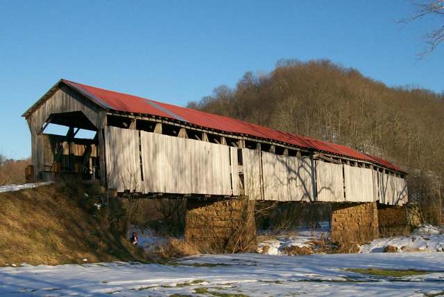
Photo: Bwsmith84, via Wikimedia Commons, CC BY 3.0 · Wikimedia Commons
Local history sources: monroe.ohgenweb.org · en.wikipedia.org · en.wikipedia.org · commons.wikimedia.org
Historic places
1 place in Washington Township, Monroe County on the National Register of Historic Places. Press a pin or a name for its whole record.
-
Knowlton Covered BridgeStructure · Rinards Mills · listed 1980
- Address
- N of Rinards Mills on SR 387-A
- Where
- Rinards Mills, Monroe County · ZIP 45767
- What it is
- Structure
- Listed on the National Register
- 1980
- NRIS reference number
- 80003165
- Coordinates
- 39.60120, -81.15719
National Register file (NPS) ↗ Search Wikipedia ↗ Street map and directions ↗ On the Cracked Buckeye map
Source: National Park Service, National Register of Historic Places point file. The listing year is shown where NPS's certification date agrees with the listing's reference number. Listing recognizes significance; it does not restrict a private owner.
Water
Mostly private wells The water here
- Woodsfield Village55% of residentsVillage-owned reservoirs (incl. Rubel Lake)
- Matamoras Village44% of residentsGroundwater wells (2 wells)
- Monroe Water Systems1% of residentsGroundwater wells (5 wells)
Hospitals, fire stations and more
Inside Washington Township, Monroe County's boundary: 2 poor-rated bridges and 23 shale and injection wells. Press a pin or a name for its whole record and its source.
Bridges rated poor (2)
-
Rias Run over Straight ForkPoor · built 1900
- Condition
- Poor: a deck, superstructure, substructure or culvert rated 4 or below on the 0 to 9 scale
- What it is
- Bridge
- Built
- 1900
- Length
- 12 ft
- Owner
- County
- Vehicles a day
- 25
- Coordinates
- 39.66156, -81.18763
National Bridge Inventory (source) ↗ Street map and directions ↗
-
SR 537 over Rias RunPoor · built 1927
- Condition
- Poor: a deck, superstructure, substructure or culvert rated 4 or below on the 0 to 9 scale
- What it is
- Bridge
- Built
- 1927
- Length
- 10 ft
- Owner
- State
- Vehicles a day
- 134
- Coordinates
- 39.64023, -81.21161
National Bridge Inventory (source) ↗ Street map and directions ↗
Source: FHWA National Bridge Inventory 2025. "Poor" means one major part rated 4 or below on the 0 to 9 scale; it calls for repair, not closing, unless the state posts or closes the bridge.
Shale and injection wells (23)
-
Donato 210568 3AUtica shale well
- What it is
- Utica shale well
- Drilled sideways
- Yes
- Operator
- Gulfport Appalachia Llc
- County
- Monroe County
- API well number
- 34111245610000
- Coordinates
- 39.64466, -81.19265
ODNR oil and gas wells (source) ↗ Street map and directions ↗
The point is the surface well head (the pad); a horizontal well runs a mile or more underground from it.
-
Donato 210568 4BUtica shale well
- What it is
- Utica shale well
- Drilled sideways
- Yes
- Operator
- Gulfport Appalachia Llc
- County
- Monroe County
- API well number
- 34111245620000
- Coordinates
- 39.64468, -81.19259
ODNR oil and gas wells (source) ↗ Street map and directions ↗
The point is the surface well head (the pad); a horizontal well runs a mile or more underground from it.
-
Donato 210637 1AUtica shale well
- What it is
- Utica shale well
- Drilled sideways
- Yes
- Operator
- Gulfport Appalachia Llc
- County
- Monroe County
- API well number
- 34111245590000
- Coordinates
- 39.64460, -81.19277
ODNR oil and gas wells (source) ↗ Street map and directions ↗
The point is the surface well head (the pad); a horizontal well runs a mile or more underground from it.
-
Donato 210637 2BUtica shale well
- What it is
- Utica shale well
- Drilled sideways
- Yes
- Operator
- Gulfport Appalachia Llc
- County
- Monroe County
- API well number
- 34111245600000
- Coordinates
- 39.64463, -81.19271
ODNR oil and gas wells (source) ↗ Street map and directions ↗
The point is the surface well head (the pad); a horizontal well runs a mile or more underground from it.
-
Gary Green N Wsh Mn 1HUtica shale well
- What it is
- Utica shale well
- Drilled sideways
- Yes
- Operator
- Gulfport Appalachia Llc
- County
- Monroe County
- API well number
- 34111243550000
- Coordinates
- 39.67634, -81.18857
ODNR oil and gas wells (source) ↗ Street map and directions ↗
The point is the surface well head (the pad); a horizontal well runs a mile or more underground from it.
-
Gary Green N Wsh Mn 3H-AUtica shale well
- What it is
- Utica shale well
- Drilled sideways
- Yes
- Operator
- Gulfport Appalachia Llc
- County
- Monroe County
- API well number
- 34111245410000
- Coordinates
- 39.67639, -81.18856
ODNR oil and gas wells (source) ↗ Street map and directions ↗
The point is the surface well head (the pad); a horizontal well runs a mile or more underground from it.
-
Gary Green N Wsh Mn 5H (703N-4H)Utica shale well
- What it is
- Utica shale well
- Drilled sideways
- Yes
- Operator
- Gulfport Appalachia Llc
- County
- Monroe County
- API well number
- 34111244290000
- Coordinates
- 39.67647, -81.18854
ODNR oil and gas wells (source) ↗ Street map and directions ↗
The point is the surface well head (the pad); a horizontal well runs a mile or more underground from it.
-
Gary Green S Wsh Mn 2H (703S-5H)Utica shale well
- What it is
- Utica shale well
- Drilled sideways
- Yes
- Operator
- Gulfport Appalachia Llc
- County
- Monroe County
- API well number
- 34111244300000
- Coordinates
- 39.67619, -81.18862
ODNR oil and gas wells (source) ↗ Street map and directions ↗
The point is the surface well head (the pad); a horizontal well runs a mile or more underground from it.
-
Gary Green S Wsh Mn 4HaUtica shale well
- What it is
- Utica shale well
- Drilled sideways
- Yes
- Operator
- Gulfport Appalachia Llc
- County
- Monroe County
- API well number
- 34111245630000
- Coordinates
- 39.67652, -81.18852
ODNR oil and gas wells (source) ↗ Street map and directions ↗
The point is the surface well head (the pad); a horizontal well runs a mile or more underground from it.
-
Gary Green S Wsh Mn 6H (703S-8H)Utica shale well
- What it is
- Utica shale well
- Drilled sideways
- Yes
- Operator
- Gulfport Appalachia Llc
- County
- Monroe County
- API well number
- 34111244270000
- Coordinates
- 39.67631, -81.18859
ODNR oil and gas wells (source) ↗ Street map and directions ↗
The point is the surface well head (the pad); a horizontal well runs a mile or more underground from it.
-
Jacobs 211061 4AUtica shale well
- What it is
- Utica shale well
- Drilled sideways
- Yes
- Operator
- Gulfport Appalachia Llc
- County
- Monroe County
- API well number
- 34111246640000
- Coordinates
- 39.67760, -81.17002
ODNR oil and gas wells (source) ↗ Street map and directions ↗
The point is the surface well head (the pad); a horizontal well runs a mile or more underground from it.
-
Whitacre Enterpises Inc 701 N-1HUtica shale well
- What it is
- Utica shale well
- Drilled sideways
- Yes
- Operator
- Gulfport Appalachia Llc
- County
- Monroe County
- API well number
- 34111243210000
- Coordinates
- 39.66072, -81.20043
ODNR oil and gas wells (source) ↗ Street map and directions ↗
The point is the surface well head (the pad); a horizontal well runs a mile or more underground from it.
-
Whitacre Enterprises Inc 701 N-2HUtica shale well
- What it is
- Utica shale well
- Drilled sideways
- Yes
- Operator
- Gulfport Appalachia Llc
- County
- Monroe County
- API well number
- 34111243020300
- Coordinates
- 39.66077, -81.20026
ODNR oil and gas wells (source) ↗ Street map and directions ↗
The point is the surface well head (the pad); a horizontal well runs a mile or more underground from it.
-
Whitacre Enterprises Inc 701 N-3HUtica shale well
- What it is
- Utica shale well
- Drilled sideways
- Yes
- Operator
- Gulfport Appalachia Llc
- County
- Monroe County
- API well number
- 34111243220000
- Coordinates
- 39.66083, -81.20019
ODNR oil and gas wells (source) ↗ Street map and directions ↗
The point is the surface well head (the pad); a horizontal well runs a mile or more underground from it.
-
Whitacre Enterprises Inc 701 S-4HUtica shale well
- What it is
- Utica shale well
- Drilled sideways
- Yes
- Operator
- Gulfport Appalachia Llc
- County
- Monroe County
- API well number
- 34111243120000
- Coordinates
- 39.66070, -81.20032
ODNR oil and gas wells (source) ↗ Street map and directions ↗
The point is the surface well head (the pad); a horizontal well runs a mile or more underground from it.
-
Whitacre Enterprises Inc 701 S-5H-AUtica shale well
- What it is
- Utica shale well
- Drilled sideways
- Yes
- Operator
- Gulfport Appalachia Llc
- County
- Monroe County
- API well number
- 34111243300000
- Coordinates
- 39.66081, -81.20023
ODNR oil and gas wells (source) ↗ Street map and directions ↗
The point is the surface well head (the pad); a horizontal well runs a mile or more underground from it.
-
Whitacre Enterprises Inc 701 S-6HUtica shale well
- What it is
- Utica shale well
- Drilled sideways
- Yes
- Operator
- Gulfport Appalachia Llc
- County
- Monroe County
- API well number
- 34111243130000
- Coordinates
- 39.66084, -81.20020
ODNR oil and gas wells (source) ↗ Street map and directions ↗
The point is the surface well head (the pad); a horizontal well runs a mile or more underground from it.
-
Whitacre Enterprises Inc 702 N-1HUtica shale well
- What it is
- Utica shale well
- Drilled sideways
- Yes
- Operator
- Gulfport Appalachia Llc
- County
- Monroe County
- API well number
- 34111243280000
- Coordinates
- 39.67648, -81.20069
ODNR oil and gas wells (source) ↗ Street map and directions ↗
The point is the surface well head (the pad); a horizontal well runs a mile or more underground from it.
-
Whitacre Enterprises Inc 702 N-2HUtica shale well
- What it is
- Utica shale well
- Drilled sideways
- Yes
- Operator
- Gulfport Appalachia Llc
- County
- Monroe County
- API well number
- 34111243290000
- Coordinates
- 39.67649, -81.20074
ODNR oil and gas wells (source) ↗ Street map and directions ↗
The point is the surface well head (the pad); a horizontal well runs a mile or more underground from it.
-
Whitacre Enterprises Inc 702 N-3HUtica shale well
- What it is
- Utica shale well
- Drilled sideways
- Yes
- Operator
- Gulfport Appalachia Llc
- County
- Monroe County
- API well number
- 34111243200000
- Coordinates
- 39.67650, -81.20080
ODNR oil and gas wells (source) ↗ Street map and directions ↗
The point is the surface well head (the pad); a horizontal well runs a mile or more underground from it.
-
Whitacre Enterprises Inc 702 S-4HUtica shale well
- What it is
- Utica shale well
- Drilled sideways
- Yes
- Operator
- Gulfport Appalachia Llc
- County
- Monroe County
- API well number
- 34111243260000
- Coordinates
- 39.67647, -81.20064
ODNR oil and gas wells (source) ↗ Street map and directions ↗
The point is the surface well head (the pad); a horizontal well runs a mile or more underground from it.
-
Whitacre Enterprises Inc 702 S-5HUtica shale well
- What it is
- Utica shale well
- Drilled sideways
- Yes
- Operator
- Gulfport Appalachia Llc
- County
- Monroe County
- API well number
- 34111243250000
- Coordinates
- 39.67646, -81.20059
ODNR oil and gas wells (source) ↗ Street map and directions ↗
The point is the surface well head (the pad); a horizontal well runs a mile or more underground from it.
-
Whitacre Enterprises Inc 702 S-6HUtica shale well
- What it is
- Utica shale well
- Drilled sideways
- Yes
- Operator
- Gulfport Appalachia Llc
- County
- Monroe County
- API well number
- 34111243240000
- Coordinates
- 39.67645, -81.20054
ODNR oil and gas wells (source) ↗ Street map and directions ↗
The point is the surface well head (the pad); a horizontal well runs a mile or more underground from it.
Source: ODNR Division of Oil and Gas Resources well inventory (September 2026): drilled Utica, Marcellus and horizontal wells and Class II injection wells not plugged. Older vertical wells are on the full map.
Its ZIP codes
Each ZIP code that touches Washington Township, Monroe County, with the share of its residents who live here and the same headline figures as the ZIP page.
| ZIP | Share | Water | Radon | Home value | Schools | Flood |
|---|---|---|---|---|---|---|
| 45734 Washington Township and Graysville | 66% | Mostly private wells | Too few radon tests | Median year built 1972 | Switzerland of Ohio Local · 3 stars overall | 1.0% of residents in the 1% floodplain |
| 45767 Grandview Township and New Matamoras | 2% | Mostly private wells | 4.8 pCi/L average radon | Median year built 1960 | Frontier Local · 3 stars overall | 9.7% of residents in the 1% floodplain |
| 43793 Woodsfield | 1% | Mostly private wells | 4.5 pCi/L average radon | Median year built 1957 | Switzerland of Ohio Local · 3 stars overall | 0.7% of residents in the 1% floodplain |
Local government
Who holds office in Washington Township, Monroe County, how its elections and ballot issues came out, and the state auditor's record.
Money issues on the ballot since 2022: 1 of 1 passed.
Ballot issues
| Date | Issue | For | Against | Result |
|---|---|---|---|---|
| 2022-05-03 | Issue: Washington Twp Tax Levy Renewal | 54 | 21 | Passed (72.0% for) |
Elections for office
| Date | Office | Candidates and votes |
|---|---|---|
| 2021-11-02 | Township Trustee | Larry E. Gardner 73, 37.63%; Keith Knowlton 69, 35.57%; Brad Loch 52, 26.8% |
| 2019-11-05 | Township Trustee | Kevin Howell 84, 100.0% |
| 2019-11-05 | Township Fiscal Officer | Amy Winland 88, 100.0% |
Winners in bold. Results from the county board of elections' official canvass unless marked.
Auditor of State record
- No fiscal caution, watch or emergency on the Auditor of State's lists.
- Agreed Upon Procedures, 2024 to 2025, released 2026-08-04
- Basic Audit, 2022 to 2023, released 2024-08-13
The county
Monroe County: 10 ZIP codes, 27 cities, villages and townships, 13,100 people.
Nearby places
Quick answers
What county is Washington Township, Ohio in?
Washington Township, Monroe County is a township in Monroe County, Ohio, with 359 residents.
When was Washington Township, Ohio founded?
Washington Township, Monroe County was settled 1804 (Isaac Brown, Joseph and William Cline); incorporated 1832-06-05 (township organized). Source
What ZIP code is Washington Township, Ohio?
Washington Township, Monroe County is served by ZIP codes 45734 and 45767; 45734 holds the largest share of its residents.
Where does Washington Township, Ohio get its water?
The main water source for Washington Township, Monroe County (Woodsfield Village): Mostly private wells.
Cite this page
Cite this page as:
Cracked Buckeye, "Washington Township, Monroe County", https://crackedbuckeye.com/place/washington-township-monroe-county/, built 2026-10-31, accessed [date].
How to cite · Report a correction · Built 2026-10-31
