Fairfield Township, Tuscarawas County
Township · Tuscarawas County · 1,509 residents
Local events in Fairfield Township, Tuscarawas County
Nothing is posted for Fairfield Township itself yet; here is what is on within 20 miles. All local events in Fairfield Township, Tuscarawas County
Know a calendar we should watch? Send the link
Checked October 20; the events page is refreshed daily.
How Fairfield Township, Tuscarawas County began
Fairfield Township, in south-central Tuscarawas County, was formed on June 2, 1817 from Township 9, Range 1 and first settled before 1807 by Gideon Jennings, Aaron Reeves and Abel Williams in the Tuscarawas valley. Coal, iron ore and black-band ore underlie its hills, and a charcoal furnace in the northwest later worked by the Zoar Separatists supplied the early market. Its villages were small: Fairfield (platted 1854, later Zoar Station), the failed Savana (1834), the lost Mount Tabor, and Valley City, laid out by the Zoar society in 1882 and later called Zoarville. The 2020 census counted 1,509 residents.
Settled before 1807 (Gideon Jennings, Aaron Reeves, Abel Williams), platted 1882 (Zoarville, platted as Valley City), incorporated June 2, 1817 (formed by the county commissioners), by county commissioners; first pioneers Gideon Jennings, Aaron Reeves and Abel Williams.
Where the name comes from
The county history gives no account of why the township was called Fairfield; it says only that it was formed by the commissioners on June 2, 1817. Within it, the post office called Zoar Station from 1861 was renamed Zoarville in 1914, and the hamlet platted in 1882 as Valley City is now called Zoarville.
Before the town
The 1884 county history says that when Gideon Jennings built his cabin near the mouth of One Leg Creek, Indians still roved in large bands through the country and his house stood on a trail from the lakes to the Ohio used by hunting parties; it describes friendly but troublesome visits, and a false alarm during the War of 1812 when a hunter was mistaken for an Indian. No mound, village or earthwork in the township is recorded. The land lies in the Treaty of Greenville (1795) cession.
Nations recorded here: Lenape (Delaware).
- Trail from the lakes to the Ohio at One Leg Creek (trail) — mouth of One Leg Creek, northwest part of the township, c. 1800-1810 (archive.org)
Timeline
- — Gideon Jennings, Aaron Reeves and Abel Williams, the township's three earliest pioneers, have all settled in the Tuscarawas valley by this date; Jennings builds a cabin near the mouth of One Leg Creek on a trail from the lakes to the Ohio.
- — The Methodist circuit rider J. B. Finley holds the first religious service in the township at the cabin of the trapper Aaron Reeves, beginning a class that grew into a society still meeting in 1884.
- — The county commissioners form Fairfield Township on June 2 from Township 9, Range 1; citizens are told to meet at George Kollar's house on June 17 to elect officers.
- — Savana, a 39-lot town west of the river near the Ohio Canal, is platted on June 12 for Edward Ogden, David McConnell and Israel S. Lappin; it comes to nothing.
- — St. Matthew's Evangelical Lutheran Church is built in the northwest corner of Section 19, on a lot given by Silas Williams; it is enlarged in 1872 or 1873 at a cost of $1,300.
- — Samuel and Worthington Slutts lay out the village of Fairfield, 30 lots on Broadway, Fair and Conotton streets, on the Tuscarawas branch of the Cleveland and Pittsburgh Railroad; it never grows beyond a few houses and a store.
- — A post office named Zoar Station opens serving the Conotton Creek hamlet within the township.
- — The Zoarville Bridge, a Fink through-truss span, is built across Conotton Creek near the hamlet.
- — The Mount Zion and Tuscarawas Valley German Baptist (Dunkard) church is built, at a cost of about $4,000.
- — In October the Separatists of Zoar lay off the town of Valley City, 28 lots, on the Fairfield-Sandy township line near the junction of the railroads.
- — The Zoarville Bridge is listed on the National Register of Historic Places on March 13.
Stories
Zoarville is not Zoar
Fairfield Township's Conotton Creek hamlet of Zoarville is a separate place from the better-known communal village of Zoar; the two are administratively distinct: Zoar itself, founded in 1817 by German Separatist Pietists and a National Historic Landmark District since 2016, lies to the northwest in Lawrence Township, while Zoarville is a small, separately platted rail hamlet inside Fairfield Township. Zoarville began as a post office called Zoar Station in 1861, was platted under the unrelated name Valley City in 1882, and only took the name Zoarville when its post office was renamed in 1914. Its most notable structure is the Zoarville Bridge, an 1868 iron span across Conotton Creek east of the State Routes 212/800 junction — photographed by the National Park Service's Historic American Engineering Record and listed on the National Register of Historic Places in 1997.
The trapper and the circuit rider
Aaron Reeves was a hunter and trapper who settled at the mouth of One Leg Creek and whom his neighbors regarded with some dread. Methodist preacher J. B. Finley, riding a long circuit in 1809, stopped at his cabin for a meal and, in his own account, challenged him to a shooting match; Finley won two of three rounds and was given leave to return in four weeks to preach. The neighbors gathered, and on later visits Reeves and his family were converted and he became the leader of a class that met in his cabin. A log church was later built in the One Leg bottoms, on ground so low that freshets sometimes entered the windows, and a frame church on the hill later replaced it. Reeves himself had once chased angry Indian visitors out of his cabin with a chair post when they suspected him of shooting a favorite dog.
Photographs
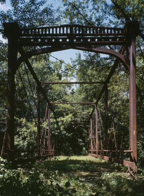
Photo: Joseph Elliott, U.S. National Park Service Historic American Engineering Record (HAER OH-84-18), public domain · Wikimedia Commons
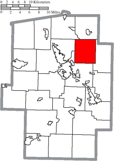
Photo: Ruhrfisch and Nyttend, CC BY-SA 3.0 · Wikimedia Commons
Local history sources: en.wikipedia.org · en.wikipedia.org · en.wikipedia.org · en.wikipedia.org · en.wikipedia.org · commons.wikimedia.org · commons.wikimedia.org · archive.org
Historic places
1 place in Fairfield Township, Tuscarawas County on the National Register of Historic Places. Press a pin or a name for its whole record.
-
Zoarville BridgeStructure · Zoarville · listed 1997
- Address
- Across the Conotton Cr., E of jct. of OH 212 and OH 800
- Where
- Zoarville, Tuscarawas County · ZIP 44656
- What it is
- Structure
- Listed on the National Register
- 1997
- NRIS reference number
- 97000199
- Coordinates
- 40.57729, -81.39138
National Register file (NPS) ↗ Search Wikipedia ↗ Street map and directions ↗ On the Cracked Buckeye map
Source: National Park Service, National Register of Historic Places point file. The listing year is shown where NPS's certification date agrees with the listing's reference number. Listing recognizes significance; it does not restrict a private owner.
Water
Mostly private wells The water here
- New Philadelphia City47% of residentsTuscarawas River valley sand-and-gravel aquifer (wells)
- Dover City46% of residentsSugar Creek Basin sand-and-gravel aquifer (Dover wellfield)
- Bolivar Village5% of residentsGroundwater wells (2 wells)
- Aqua Ohio - Midvale1% of residentsGroundwater wells (3 wells)
- Tcmsd-wainwright0% of residentsGroundwater wells (2 wells)
- Tuscarawas Village0% of residentsGroundwater wells (2 wells)
Hospitals, fire stations and more
Inside Fairfield Township, Tuscarawas County's boundary: 1 fire or EMS station, 1 high-hazard dam, 1 poor-rated bridge, 1 museum and 1 spill case. Press a pin or a name for its whole record and its source.
Fire and EMS stations (1)
-
Fairfield Township Volunteer Fire DepartmentSomerdale
- Address
- 6254 Firehouse Street, Somerdale, OH 44678
- Coordinates
- 40.56716, -81.35993
USGS National Map structures (source) ↗ Street map and directions ↗
Source: USGS National Map structures (most Ohio records last updated 2019 to 2022), checked against the Columbus and Cleveland station lists. The department that answers a call is set by jurisdiction and mutual aid, not by distance.
High-hazard dams (1)
-
Dover DamTuscarawas River · condition: not available
- Hazard class
- High: a failure would probably cost a life
- Condition
- Not Available
- River or stream
- Tuscarawas River
- Purpose
- Flood Risk Reduction
- Type
- Gravity
- Height
- 83 ft
- Storage
- 203,000 acre-feet
- Completed
- 1938
- Owner type
- Federal
- County
- Tuscarawas County
- Nearest town (NID)
- Dover
- Last inspection
- 06/02/2025
- Emergency action plan
- Yes
- NID ID
- OH00003
National Inventory of Dams record ↗ National Inventory of Dams (source) ↗ Street map and directions ↗
Source: U.S. Army Corps of Engineers National Inventory of Dams, August 2026. "High hazard" rates what a failure would cost downstream, not how likely one is; the condition is the state's assessment.
Bridges rated poor (1)
-
SR 800 over Tuscarawas RiverPoor · built 1978
- Condition
- Poor: a deck, superstructure, substructure or culvert rated 4 or below on the 0 to 9 scale
- What it is
- Bridge
- Built
- 1978
- Length
- 100 ft
- Owner
- State
- Vehicles a day
- 3,705
- Coordinates
- 40.57729, -81.39578
National Bridge Inventory (source) ↗ Street map and directions ↗
Source: FHWA National Bridge Inventory 2025. "Poor" means one major part rated 4 or below on the 0 to 9 scale; it calls for repair, not closing, unless the state posts or closes the bridge.
Museums, historical societies, gardens and zoos (1)
-
Mineral City Area Historical SocietyHistorical society · Mineral City
- What it is
- Historical society
- City
- Mineral City
- Coordinates
- 40.56577, -81.33613
Search Wikipedia ↗ IMLS Museum Data Files (source) ↗ Street map and directions ↗
The museum list is IMLS's 2018 file; a museum may have closed or moved since.
Source: IMLS Museum Data Files, 2018.
Spills reported since 2021 (1)
-
Material Orange Reached water2021-11-22 · Monroe Twp
- Reported
- 2021-11-22
- What spilled
- Material Orange
- Reached a waterway
- 10 - Conotton Creek
- Where
- Monroe Twp, Carroll County
- Ohio EPA district office
- SEDO
- Ohio EPA case number
- 2111EPA0001771
Ohio EPA spill reports (source) ↗ Street map and directions ↗
Source: Ohio EPA emergency response spill reports, 2021 to September 2026, one point per case where Ohio EPA placed it. A report is what the caller or responder recorded; amounts are often blank or estimated.
Its ZIP codes
Each ZIP code that touches Fairfield Township, Tuscarawas County, with the share of its residents who live here and the same headline figures as the ZIP page.
| ZIP | Share | Water | Radon | Home value | Schools | Flood |
|---|---|---|---|---|---|---|
| 44678 Fairfield Township and Somerdale | 100% | Mostly private wells | Too few radon tests | Median year built 1972 | Tuscarawas Valley Local · 4 stars overall | 12% of residents in the 1% floodplain |
| 44656 Sandy Township and Mineral City | 20% | Mostly private wells | 6.5 pCi/L average radon | Median year built 1961 | Tuscarawas Valley Local · 4 stars overall | 7.8% of residents in the 1% floodplain |
| 44622 Dover | 2% | Sugar Creek Basin sand-and-gravel aquifer (Dover wellfield) | 6.0 pCi/L average radon | Median year built 1956 | Dover City · 3.5 stars overall | 2.9% of residents in the 1% floodplain |
| 44663 New Philadelphia | 1% | Wells in the sand-and-gravel aquifer within the Tuscarawas River valley near New Philadelphia | 5.3 pCi/L average radon | Median year built 1956 | New Philadelphia City · 3 stars overall | 5.2% of residents in the 1% floodplain |
Local government
Who holds office in Fairfield Township, Tuscarawas County, how its elections and ballot issues came out, and the state auditor's record.
Elections for office
| Date | Office | Candidates and votes |
|---|---|---|
| 2019-11-05 | Township Trustee | William H. Beans 118, 100.0% |
| 2019-11-05 | Township Fiscal Officer | Jennifer L. Brown 119, 100.0% |
Winners in bold. Results from the county board of elections' official canvass unless marked.
Auditor of State record
- No fiscal caution, watch or emergency on the Auditor of State's lists.
- Agreed Upon Procedures, 2024 to 2025, released 2026-05-28
The county
Tuscarawas County: 17 ZIP codes, 40 cities, villages and townships, 92,903 people.
Nearby places
Quick answers
What county is Fairfield Township, Ohio in?
Fairfield Township, Tuscarawas County is a township in Tuscarawas County, Ohio, with 1,509 residents.
When was Fairfield Township, Ohio founded?
Fairfield Township, Tuscarawas County was settled before 1807 (Gideon Jennings, Aaron Reeves, Abel Williams); laid out 1882 (Zoarville, platted as Valley City); incorporated June 2, 1817 (formed by the county commissioners). Founders on record: county commissioners; first pioneers Gideon Jennings, Aaron Reeves and Abel Williams. Source
How did Fairfield Township, Ohio get its name?
The county history gives no account of why the township was called Fairfield; it says only that it was formed by the commissioners on June 2, 1817. Source
What ZIP code is Fairfield Township, Ohio?
Fairfield Township, Tuscarawas County is served by ZIP codes 44678 and 44656; 44678 holds the largest share of its residents.
Where does Fairfield Township, Ohio get its water?
The main water source for Fairfield Township, Tuscarawas County (New Philadelphia City): Mostly private wells.
Cite this page
Cite this page as:
Cracked Buckeye, "Fairfield Township, Tuscarawas County", https://crackedbuckeye.com/place/fairfield-township-tuscarawas-county/, built 2026-10-31, accessed [date].
How to cite · Report a correction · Built 2026-10-31
