Local events in Union Township, Ross County
Nothing is posted for Union Township itself yet; here is what is on within 10 miles. All local events in Union Township, Ross County
Know a calendar we should watch? Send the link
Checked October 20; the events page is refreshed daily.
Deep dives about Union Township, Ross County
Long reads built from maps, newspapers and public records. All deep dives
How Union Township, Ross County began
Union Township lies immediately north of the city of Chillicothe along the Scioto River, organized as one of Ross County's original townships in the years after General Nathaniel Massie's surveying party occupied the Chillicothe area in the spring of 1796. It takes a generic, common Ohio township name (twenty-seven other Union Townships exist statewide) and its early population included men from Massie's own founding party who took up farms nearby rather than staying in town. The Hopewell-era Mound City Group sits within the township along State Route 104, with the Hopeton Earthworks across the Scioto on its east bank, making its Native American record far older and better documented than its township-era one. Today the township has no incorporated municipality of its own; Ross Correctional Institution and the northern reach of Chillicothe's water and sewer customers are within its bounds.
Settled 1796, by Settlers from Nathaniel Massie's Chillicothe party, exact township organization date not established in sources consulted.
Where the name comes from
No source consulted gives a specific origin for the name 'Union' in this township; it is one of twenty-seven Union Townships in Ohio, a common name choice for township organizers in the early 1800s with no further explanation recorded.
Before the town
No source consulted names a specific historic Shawnee, Wyandot, or other 18th-century village site inside Union Township itself; the well-documented Shawnee towns near Chillicothe (a settlement at the Chillicothe site from 1758, and the Pickaway Plains towns of Cornstalk's Town, Grenadier Squaw Town, Kispoko Town and Lower Shawneetown) are placed at or near the city site and along the Scioto and Scippo Creek to the north toward Circleville, not specifically within this township's boundary; the Ross County history gives the fuller county-wide native record. What is firmly documented within the township is much older: the Hopewell culture (about 200 BC to AD 500) built the Mound City Group, a roughly square earthwork enclosure holding 25 conical and spherical burial mounds, and, about a mile to the east across the river, the Hopeton Earthworks, a circle-and-square geometric enclosure with solstice-aligned openings on the Scioto's east bank north of Chillicothe. The Chillicothe area as a whole, sometimes called the 'Chillicothe cluster,' held one of the densest concentrations of Hopewell ceremonial earthworks in eastern North America.
Nations recorded here: Shawnee, Hopewell culture, Adena culture.
- Mound City Group (mound) — East bank of the Scioto River on State Route 104, Union Township, Ross County (39.3758°N, 83.0044°W), Hopewell culture, c. 200 BC - AD 500 (commons.wikimedia.org)
- Hopeton Earthworks (earthwork) — East bank of the Scioto River, just north of Chillicothe, Ross County, Hopewell culture, c. 200 BC - AD 500 (en.wikipedia.org)
Timeline
- — A Shawnee settlement is recorded at the site that became Chillicothe, on the Scioto just south of present Union Township.
- — The Treaty of Greenville, following the 1794 Battle of Fallen Timbers, opens most of the future Ross County to American surveying and settlement.
- — General Nathaniel Massie's party occupies the Chillicothe site in the spring; some members of the party go on to settle in what becomes Union Township, just north of town.
- — Chillicothe builds its first municipal water supply system, with a well, reservoir, water mains and a Gothic Revival pumping station on Enderlin Circle at the edge of Yoctangee Park.
- — The city opens a new water treatment plant on Park Street; the site is later cleared and becomes Veterans Memorial Park.
- — The 1881 pumping station is listed on the National Register of Historic Places (ref. 79001932); it later becomes the Pump House Center for the Arts.
- — Chillicothe's current water treatment plant, in Yoctangee Park, goes into service.
Stories
A capital's overflow settles the plain to the north
When Nathaniel Massie's surveying party occupied the mouth of Paint Creek in the spring of 1796, most of the men who came with him had been promised free town lots to build up the new settlement fast. Not everyone stayed in town. As the surrounding land was surveyed and opened, a number of Massie's own party moved out onto the fertile plain north of Chillicothe, along the Scioto, and took up farms rather than town lots — this stretch became Union Township. The township never grew a town of its own; it stayed rural even as Chillicothe below it became the first capital of Ohio in 1803. Two thousand years earlier, people of the Hopewell culture had already chosen the same stretch of river bottom for their most important ceremonial ground, building Mound City and the Hopeton earthworks on the same terraces the farms would later occupy.
A Gothic pump house doubles as a park ornament
When Chillicothe built its first municipal water system in 1881, the city council did not want a plain utility shed sitting at the edge of its new Yoctangee Park. The pumping station that went up on Enderlin Circle was built in Gothic Revival style, brick on a sandstone foundation under a slate roof, with a two-story tower rising over the single-story pump hall — designed to read as a park building, not a factory. It pumped the city's water and, for a time, generated its electricity, until new waterworks and outside power made it obsolete by the late 1970s. Rather than tear it down, the city listed it on the National Register in 1979 and turned it into the Pump House Center for the Arts, which it remains.
Photographs
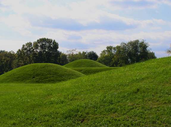
Photo: Herb Roe (Heironymous Rowe), CC BY-SA 3.0 · Wikimedia Commons
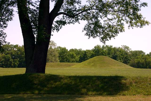
Photo: Rdikeman (RickDikeman), CC BY-SA 3.0 · Wikimedia Commons
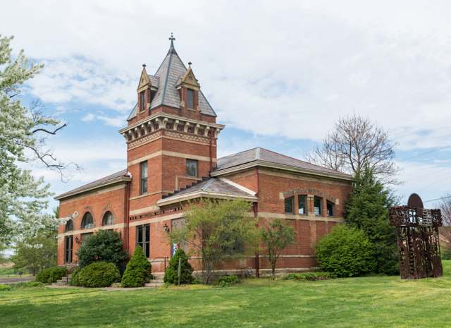
Photo: Wikimedia Commons user ұ, CC BY-SA 4.0 · Wikimedia Commons
Local history sources: en.wikipedia.org · en.wikipedia.org · en.wikipedia.org · en.wikipedia.org · en.wikipedia.org · en.wikipedia.org · en.wikipedia.org · commons.wikimedia.org · commons.wikimedia.org · commons.wikimedia.org · mix1065.iheart.com
Historic places
3 places in Union Township, Ross County on the National Register of Historic Places. Press a pin or a name for its whole record.
-
Anderson, Levi, HouseBuilding · Chillicothe · listed 1976
- Address
- W of Chillicothe on Anderson Station Rd.
- Where
- Chillicothe, Ross County · ZIP 45601
- What it is
- Building
- Listed on the National Register
- 1976
- NRIS reference number
- 76001524
- Coordinates
- 39.36075, -83.07555
National Register file (NPS) ↗ Search Wikipedia ↗ Street map and directions ↗ On the Cracked Buckeye map
-
Mace, Henry, HouseBuilding · Chillicothe · listed 1998
- Address
- 17380 OH 104 N
- Where
- Chillicothe, Ross County · ZIP 45601
- What it is
- Building
- Listed on the National Register
- 1998
- NRIS reference number
- 98000101
- Coordinates
- 39.39232, -83.01227
National Register file (NPS) ↗ Search Wikipedia ↗ Street map and directions ↗ On the Cracked Buckeye map
-
McCafferty Run FarmsteadBuilding · Chillocothe · listed 2004
- Address
- 17114 and 17226 OH 104
- Where
- Chillocothe, Ross County · ZIP 45601
- What it is
- Building
- Listed on the National Register
- 2004
- NRIS reference number
- 04000945
- Coordinates
- 39.39025, -83.01175
National Register file (NPS) ↗ Search Wikipedia ↗ Street map and directions ↗ On the Cracked Buckeye map
Source: National Park Service, National Register of Historic Places point file. The listing year is shown where NPS's certification date agrees with the listing's reference number. Listing recognizes significance; it does not restrict a private owner.
Water
Seven active wells in the Scioto Buried River Valley Aquifer (the CCR's own name) serving the city well field near Yoctangee Park. The City of Chillicothe also has emergency connections with Ross County Water Company and the Chillicothe Correctional Institution; neither was used in 2025. The water here
- Ross County Water Co. Inc50% of residentsTeays Valley Aquifer (buried valley groundwater)
- Chillicothe City49% of residentsScioto Buried Valley Aquifer (Teays Valley system) wells
- Frankfort Village1% of residentsGroundwater wells (2 wells)
- Kingston Village1% of residentsTeays Valley Aquifer (buried valley groundwater)
- Clarksburg Village0% of residentsGroundwater wells (2 wells)
- Williamsport Village0% of residentsGroundwater wells (2 wells)
- Darbyville Village0% of residentsGroundwater wells (3 wells)
Hospitals, fire stations and more
Inside Union Township, Ross County's boundary: 1 hospital, 3 fire and EMS stations, 1 power plant, 2 public schools, 1 private school, 4 poor-rated bridges, 1 museum and 11 spill cases. Press a pin or a name for its whole record and its source.
Hospitals (1)
-
Va Medical Center - ChillicotheMilitary hospital · Chillicothe
- What it is
- Military hospital
- Address
- 17273 Oh-104, Chillicothe, OH 45601
- County
- Ross County
- Beds
- 141
- Helipad
- Yes
- Ownership
- Government - federal
- Medicare overall rating
- not rated
- Emergency department (Medicare)
- No
- Medicare reports it as
- Chillicothe Va Medical Center
- Phone
- (740) 773-1141
- Medicare ID
- 36008F
Medicare Care Compare ↗ Hospital's website ↗ Where HIFLD got this record ↗ HIFLD hospitals (source) ↗ Street map and directions ↗
Source: HIFLD hospitals inventory via FEMA (closed hospitals it still lists left out, hospitals opened since added), with Medicare Care Compare ratings matched by name and address.
Fire and EMS stations (3)
-
Union Township Fire Department Station 1Chillicothe
- Address
- 12034 Pleasant Valley Road, Chillicothe, OH 45601
- Coordinates
- 39.37228, -83.05234
USGS National Map structures (source) ↗ Street map and directions ↗
-
Union Township Fire Department Station 2Chillicothe
- Address
- 5778 Egypt Pike, Chillicothe, OH 45601
- Coordinates
- 39.41768, -83.05759
USGS National Map structures (source) ↗ Street map and directions ↗
-
Union Township Fire Department Station 3Chillicothe
- Address
- 239 Yellowbud Road, Chillicothe, OH 45601
- Coordinates
- 39.49794, -83.01162
USGS National Map structures (source) ↗ Street map and directions ↗
Source: USGS National Map structures (most Ohio records last updated 2019 to 2022), checked against the Columbus and Cleveland station lists. The department that answers a call is set by jurisdiction and mutual aid, not by distance.
Power plants (1)
-
Yellowbud Solar, LLC 100 MW or moreSolar · 274 MW
- Capacity
- 274 MW
- Main source
- Solar
- Technology
- Solar Photovoltaic
- Operator
- Yellowbud Solar LLC
- Sector
- IPP Non-CHP
- Where
- Williamsport, Ross County
- Generating units
- 1
- Built
- 2023
- EIA plant code
- 64832
EIA plant page ↗ EIA-860 (source) ↗ Street map and directions ↗
Source: EIA-860 power plant inventory via HIFLD (February 2025), with plant codes, units and years from EIA-860 2025.
Public schools (2)
-
Unioto Elementary4 of 5 stars · Chillicothe
- Address
- 138 Sandusky Blvd, Chillicothe, OH 45601
- School district
- Union-Scioto Local School District
- Kind (NCES)
- Regular School
- Students, 2023-24
- 1,035
- Teachers (full-time equivalent)
- 54
- Report card, 2025-26
- 4 of 5 stars
- Performance index
- 76.7%
- Ohio building IRN
- 000231
- NCES school ID
- 390495305302
NCES school record ↗ Ohio School Report Card ↗ Street map and directions ↗
-
Unioto Middle School4 of 5 stars · Chillicothe
- Address
- 160 Moundsville Rd, Chillicothe, OH 45601
- School district
- Union-Scioto Local School District
- Kind (NCES)
- Regular School
- Students, 2023-24
- 487
- Teachers (full-time equivalent)
- 20
- Report card, 2025-26
- 4 of 5 stars
- Performance index
- 79.3%
- Ohio building IRN
- 065532
- NCES school ID
- 390495301094
NCES school record ↗ Ohio School Report Card ↗ Street map and directions ↗
Source: NCES EDGE public school locations 2024-25 and Common Core of Data 2023-24 (type, students, teachers); Ohio School Report Cards 2025-26 (Department of Education and Workforce), matched by name within the district.
Private schools (1)
-
Ross County Christian AcademyPrivate, conservative Christian · Chillicothe
- Address
- 2215 Egypt Pike, Chillicothe, OH 45601
- Kind
- conservative Christian
- Students, 2023-24
- 364
- Teachers (full-time equivalent)
- 33.1
- Students per teacher
- 10.997
- Phone
- (740) 701-1226
- NCES private school ID
- A0902595
Source: NCES Private School Survey 2023-24.
Bridges rated poor (4)
-
Maple Grove Rd over North Fork of Paint Cr.Poor · built 1990
- Condition
- Poor: a deck, superstructure, substructure or culvert rated 4 or below on the 0 to 9 scale
- What it is
- Bridge
- Built
- 1990
- Length
- 67 ft
- Owner
- County
- Vehicles a day
- 410
- Coordinates
- 39.35876, -83.08301
National Bridge Inventory (source) ↗ Street map and directions ↗
-
SR 207 over StreamPoor · built 1975
- Condition
- Poor: a deck, superstructure, substructure or culvert rated 4 or below on the 0 to 9 scale
- What it is
- Bridge
- Built
- 1975
- Length
- 8 ft
- Owner
- State
- Vehicles a day
- 2,409
- Coordinates
- 39.40843, -83.02583
National Bridge Inventory (source) ↗ Street map and directions ↗
-
SR 207 over Sugar RunPoor · built 1934
- Condition
- Poor: a deck, superstructure, substructure or culvert rated 4 or below on the 0 to 9 scale
- What it is
- Bridge
- Built
- 1934
- Length
- 12 ft
- Owner
- State
- Vehicles a day
- 1,094
- Coordinates
- 39.46131, -83.08881
National Bridge Inventory (source) ↗ Street map and directions ↗
-
Westfall Rd over Deer CreekPoor · built 1969
- Condition
- Poor: a deck, superstructure, substructure or culvert rated 4 or below on the 0 to 9 scale
- What it is
- Bridge
- Built
- 1969
- Length
- 57 ft
- Owner
- County
- Vehicles a day
- 650
- Coordinates
- 39.48680, -83.08381
National Bridge Inventory (source) ↗ Street map and directions ↗
Source: FHWA National Bridge Inventory 2025. "Poor" means one major part rated 4 or below on the 0 to 9 scale; it calls for repair, not closing, unless the state posts or closes the bridge.
Museums, historical societies, gardens and zoos (1)
-
Hopewell Culture National Historical ParkHistorical society · Chillicothe
- What it is
- Historical society
- City
- Chillicothe
- Coordinates
- 39.37371, -83.00737
Search Wikipedia ↗ IMLS Museum Data Files (source) ↗ Street map and directions ↗
The museum list is IMLS's 2018 file; a museum may have closed or moved since.
Source: IMLS Museum Data Files, 2018.
Spills reported since 2021 (11)
-
Oil Motor / Lube Oil / Vehicle2025-12-28 · Union Twp
- Reported
- 2025-12-28
- What spilled
- Oil Motor / Lube Oil / Vehicle
- Where
- Union Twp, Ross County
- Ohio EPA district office
- SEDO
- Ohio EPA case number
- 2512EPA0002063
Ohio EPA spill reports (source) ↗ Street map and directions ↗
-
Fuel Diesel / Diesel Fuel (Vehicle On Or Off Road)2025-06-30 · Union Twp
- Reported
- 2025-06-30
- What spilled
- Fuel Diesel / Diesel Fuel (Vehicle On Or Off Road)
- Largest amount reported
- 125 gallons
- Where
- Union Twp, Ross County
- Ohio EPA district office
- SEDO
- Ohio EPA case number
- 2506EPA0001090
Ohio EPA spill reports (source) ↗ Street map and directions ↗
-
Asphalt / Bitumen2024-10-24 · Union Twp
- Reported
- 2024-10-24
- What spilled
- Asphalt / Bitumen
- Where
- Union Twp, Ross County
- Ohio EPA district office
- SEDO
- Ohio EPA case number
- 2410EPA0001790
Ohio EPA spill reports (source) ↗ Street map and directions ↗
-
Oil Motor / Lube Oil / Vehicle2024-04-05 · Union Twp
- Reported
- 2024-04-05
- What spilled
- Oil Motor / Lube Oil / Vehicle
- Largest amount reported
- 1 gallons
- Where
- Union Twp, Ross County
- Ohio EPA district office
- SEDO
- Ohio EPA case number
- 2404EPA0000542
Ohio EPA spill reports (source) ↗ Street map and directions ↗
-
Fuel Diesel / Diesel Fuel (Vehicle On Or Off Road)2024-03-21 · Union Twp
- Reported
- 2024-03-21
- What spilled
- Fuel Diesel / Diesel Fuel (Vehicle On Or Off Road)
- Largest amount reported
- 200 gallons
- Where
- Union Twp, Ross County
- Ohio EPA district office
- SEDO
- Ohio EPA case number
- 2403EPA0000442
Ohio EPA spill reports (source) ↗ Street map and directions ↗
-
Oil Motor / Lube Oil / Vehicle Reached water2023-05-25 · Union Twp
- Reported
- 2023-05-25
- What spilled
- Oil Motor / Lube Oil / Vehicle
- Reached a waterway
- 99 - Unnamed
- Where
- Union Twp, Ross County
- Ohio EPA district office
- SEDO
- Ohio EPA case number
- 2305EPA0000854
Ohio EPA spill reports (source) ↗ Street map and directions ↗
-
Material Green2023-02-10 · Union Twp
- Reported
- 2023-02-10
- What spilled
- Material Green
- Where
- Union Twp, Ross County
- Ohio EPA district office
- SEDO
- Ohio EPA case number
- 2302EPA0000212
Ohio EPA spill reports (source) ↗ Street map and directions ↗
-
Sewage Sludge / Biosolids Reached water2023-01-03 · Union Twp
- Reported
- 2023-01-03
- What spilled
- Sewage Sludge / Biosolids
- Largest amount reported
- 10,000 gallons
- Reached a waterway
- Paint Creek
- Where
- Union Twp, Ross County
- Ohio EPA district office
- SEDO
- Ohio EPA case number
- 2301EPA0000012
Ohio EPA spill reports (source) ↗ Street map and directions ↗
-
Chemical(S) Unk2021-06-07 · Union Twp
- Reported
- 2021-06-07
- What spilled
- Chemical(S) Unk
- Where
- Union Twp, Ross County
- Ohio EPA district office
- SEDO
- Ohio EPA case number
- 2106EPA0000807
Ohio EPA spill reports (source) ↗ Street map and directions ↗
-
Oil Motor / Lube Oil / Vehicle2021-04-19 · Union Twp
- Reported
- 2021-04-19
- What spilled
- Oil Motor / Lube Oil / Vehicle
- Largest amount reported
- 12 gallons
- Where
- Union Twp, Ross County
- Ohio EPA district office
- SEDO
- Ohio EPA case number
- 2104EPA0000540
Ohio EPA spill reports (source) ↗ Street map and directions ↗
-
Fuel Oil/ Home Heating / Heating Oil2026-03-10 · Union Twp
- Reported
- 2026-03-10
- What spilled
- Fuel Oil/ Home Heating / Heating Oil
- Where
- Union Twp, Ross County
- Ohio EPA district office
- SEDO
- Ohio EPA case number
- 2603EPA0000343
Ohio EPA spill reports (source) ↗ Street map and directions ↗
Source: Ohio EPA emergency response spill reports, 2021 to September 2026, one point per case where Ohio EPA placed it. A report is what the caller or responder recorded; amounts are often blank or estimated.
Its ZIP codes
Each ZIP code that touches Union Township, Ross County, with the share of its residents who live here and the same headline figures as the ZIP page.
Local government
Who holds office in Union Township, Ross County, how its elections and ballot issues came out, and the state auditor's record.
Auditor of State record
- No fiscal caution, watch or emergency on the Auditor of State's lists.
- Financial Audit, 2023 to 2024, released 2026-01-08
The county
Ross County: 10 ZIP codes, 25 cities, villages and townships, 77,708 people.
Nearby places
Quick answers
What county is Union Township, Ohio in?
Union Township, Ross County is a township in Ross County, Ohio, with 12,530 residents.
When was Union Township, Ohio founded?
Union Township, Ross County was settled 1796. Founders on record: Settlers from Nathaniel Massie's Chillicothe party, exact township organization date not established in sources consulted. Source
What ZIP code is Union Township, Ohio?
Union Township, Ross County is served by ZIP codes 45601, 45628 and 43115; 45601 holds the largest share of its residents.
Where does Union Township, Ohio get its water?
The main water source for Union Township, Ross County (Ross County Water Co. Inc): Seven active wells in the Scioto Buried River Valley Aquifer (the CCR's own name) serving the city well field near Yoctangee Park. The City of Chillicothe also has emergency connections with Ross County Water Company and the Chillicothe Correctional Institution; neither was used in 2025.
Cite this page
Cite this page as:
Cracked Buckeye, "Union Township, Ross County", https://crackedbuckeye.com/place/union-township-ross-county/, built 2026-10-31, accessed [date].
How to cite · Report a correction · Built 2026-10-31
