Local events in Springfield Township, Ross County
Nothing is posted for Springfield Township itself yet; here is what is on within 10 miles. All local events in Springfield Township, Ross County
Know a calendar we should watch? Send the link
Checked October 20; the events page is refreshed daily.
How Springfield Township, Ross County began
Springfield Township lies in the eastern part of Ross County, just north and east of Chillicothe, and was settled from about 1798 as land in the Virginia Military District opened for sale; disappointed claimants who lost out on choicer river-bottom tracts elsewhere in the county were among those who moved in and took up land here. It has no incorporated village of its own; the ZIP data shows the township barely registers under Chillicothe's 45601 ZIP, reflecting a place that has stayed rural farmland rather than growing a town center. Its most significant ground predates any township: the Hopeton Earthworks, a large Hopewell geometric earthwork on the Scioto River terrace, and the hills of what is now Great Seal State Park, whose river-and-hills view inspired Ohio's state seal. The township today (2020 pop. about 2,573) is still mostly farms, hills, and the state park land.
Settled c. 1798, by Early Virginia Military District land claimants; the Orr family, Leonard Neff, John Stauffer and others among them.
Where the name comes from
No source found that documents why this township was named Springfield; the name is common across Ohio townships (one of eleven Springfield Townships statewide) and no township-specific naming story was located.
Before the town
No source specific to Springfield Township names a particular historic Shawnee town site within its boundaries, and the name "Chillicothe" (Shawnee for 'principal town' or 'capital town') was applied by the Shawnee to several different towns at different times and places across Ohio, so no specific Shawnee town site is assigned here without a source. What is documented is that the Shawnee inhabited the land that is now Great Seal State Park, which lies in Springfield Township northeast of Chillicothe, before European settlement, and that several major Shawnee trails passed through the area; the view of these hills from Thomas Worthington's Adena estate, on a hilltop west of downtown Chillicothe, directly inspired the design of the Great Seal of Ohio. Separately, and predating the historic Shawnee by well over a thousand years, the Hopewell culture built a major geometric earthwork complex, the Hopeton Earthworks, on a Scioto River terrace in the township, one of the most substantial Hopewell sites in the Chillicothe area; it is now part of Hopewell Culture National Historical Park. For the fuller Native history of the surrounding area, including the historic Shawnee towns actually named at Chillicothe and its treaties and removal.
Nations recorded here: Shawnee, Hopewell culture.
- Hopeton Earthworks (earthwork) — Scioto River terrace, Springfield Township, about 1 mile east of the Mound City group, now a detached unit of Hopewell Culture National Historical Park, Hopewell culture (Middle Woodland, roughly 100 BC - AD 500) (en.wikipedia.org)
- Great Seal State Park land (other) — Great Seal State Park, Springfield Township, northeast of Chillicothe, pre-1790 (historic Shawnee occupation, exact dates not given) (en.wikipedia.org)
- Earthwork fort and circle in Springfield Township (earthwork) — Springfield Township, near the Scioto; the walls reach down to the river, prehistoric; described in 1871 (archive.org)
- Indian trace from Old Town to Salt and Raccoon creeks (trail) — through East Springfield, plain in 1805 (archive.org)
Timeline
- — John Vanasaw, a noted hunter, fires at an Indian who rises from ambush outside the stockade fort at the old station on the Scioto; the Indian falls, and the encounter is called the first duel fought in the Scioto Valley.
- — Michael Cryder, a commissary in the Revolution, emigrates to the Scioto Valley with his wife and six sons and settles in what is now West Springfield; Henry Musselman, who came from Kentucky about the same time, builds the first mill on the river and gives Hopetown its name.
- — James Orr, an immigrant from Belfast, Ireland who had already lived in South Carolina and Virginia, brings his family into the Northwest Territory and settles first at High Bank prairie in what becomes Liberty Township; his sons Thomas and Zebulon are credited with the first plowing done in Liberty Township.
- — Families including the Orrs, Leonard Neff, and John Stauffer take up land in Springfield Township as part of the wave of Virginia Military District settlers who arrived the years around Ross County's organization; Thomas Orr, James Orr's son, later owns and works a farm in Springfield Township, where he dies in 1854.
- — Jacob Weider comes from Pennsylvania and settles near Hopetown, where he keeps a tavern and distillery at Barley Forks, now Hopetown.
- — Alexander, Samuel and Daniel McRoberts, Archibald McFarland, George Wheeland and Philip Hines emigrate to the township.
- — Michael Senff, whose grandfather Casper Senff came from Germany in 1773 as a king's hunter and Revolutionary spy, comes to Ohio; he serves in the War of 1812 and dies in 1845.
- — Thomas and John Arthurs and Thomas McNeal emigrate from Brooke County, Virginia, to East Springfield, where Indian traces are still plain and arrowheads and stone axes are picked up in the fields; McNeal has often counted as many as eighty Indians in a squad passing from Old Town to Salt and Raccoon creeks to obtain lead and hunt.
- — Springfield Township is organized out of part of Green Township; Mount Logan, overlooking Chillicothe from about three miles off, is its celebrated landmark.
- — Ephraim George Squier and Edwin Hamilton Davis surveyed the Hopeton Earthworks in Springfield Township, mapping a roughly 950 by 900 foot rectangular enclosure attached to a 1,050-foot circle with walls up to 12 feet high, publishing the results in their 1848 Ancient Monuments of the Mississippi Valley.
- — Springfield Township's officers are Joseph Smith and Aaron Elliott, justices, and Leonard Moore, Andrew J. Cryder and Thomas McNeal, trustees; Colonel Sifford of West Springfield is the county's representative.
- — Hopeton Earthworks was designated a National Historic Landmark on July 19, 1964, and listed on the National Register of Historic Places on October 15, 1966, later becoming a detached unit of Hopewell Culture National Historical Park.
- — State representative Myrl Shoemaker and area politicians proposed a large new state park on the hills of Springfield Township overlooking Chillicothe; landowner objections cut the original 7,500-acre plan to under 2,000 acres, and Great Seal State Park opened to the public with limited access in 1979.
- — The census counts 2,573 people in Springfield Township.
Stories
The view that became the state seal
In the years around Ohio statehood, Thomas Worthington built his estate, Adena, on a hilltop west of downtown Chillicothe. From that hill he could see across the Scioto valley to the hills of what is now Springfield Township, the surrounding wooded ridges, and the sun rising over the river. Worthington, along with Edward Tiffin and William Creighton, drew on that view when they designed the Great Seal of the State of Ohio: a rising sun, a river, a sheaf of wheat, and a bundle of arrows against the hills. The same hills and river later became Great Seal State Park, so the ground that inspired the state's official symbol sits inside this township. Before Worthington's time, the Shawnee had lived on and moved through this same country, and several of their trails crossed it.
Land nobody else wanted
The Virginia Military District, which covers this part of Ohio, was surveyed and sold off in large, irregular tracts rather than the neat square-mile sections used elsewhere in Ohio. Settlers with money bought up the best river-bottom land first; those with less, or who arrived after the good ground was claimed, had to look elsewhere. The 1880 county history records that some of these later arrivals, disappointed in their first choices, went into the hills, while others located in Springfield Township. That pattern, hillier and later-settled than the Scioto bottoms around Chillicothe, is consistent with the township never growing a village of its own and remaining, in the ZIP data, essentially absorbed into Chillicothe's 45601 rather than showing up as a place in its own right.
A surveyor's chain and a schoolmaster's trade
James Orr left Belfast, Ireland around 1770, tried South Carolina, and settled for a time near Moorefield in what is now West Virginia before bringing his family into the Northwest Territory in 1797 and taking up land at High Bank prairie, in what became Liberty Township. He was well educated for a frontier settler, worked as a surveyor, and was one of the first schoolteachers in Ross County; he died in 1802. His son Thomas is remembered for two things: doing the first plowing in Liberty Township alongside his brother Zebulon, and carrying the surveyor's chain for Gen. Nathaniel Massie when the road from Chillicothe to Gallipolis was laid out. Thomas Orr later owned and farmed land in Springfield Township itself, where he lived until his death in 1854 - one branch of a pioneer family whose story runs through several of the county's oldest townships. A number of other early Springfield Township families appear in the same 1917 county biographical history: Leonard Neff, John Stauffer, Jacob Ringwald, Conrad Remley and the Gates and McNeal families all cleared farms in the township in the early and mid-1800s, most working land along Dry Run.
The first duel in the Scioto Valley
In 1793, with the pioneers still exposed to Indian attack, a stockade fort stood at the old station on the Scioto as a place of retreat. One morning John Vanasaw, a noted hunter, had gone only a little way from the fort when he saw an Indian rise from an ambush, painted and decked in war costume. Both men raised their rifles at once and fired; the Indian fell. Vanasaw, fearing there might be other Indians about, went back to the fort and reported what the 1871 Pioneer Record calls, with a qualifying 'so called,' the first duel fought in the Scioto Valley. Years afterward, in 1805, Thomas McNeal in East Springfield would recall counting as many as eighty Indians in a single squad on the trace from Old Town to Salt Creek and Raccoon Creek, going for lead and game, who generally came back with their pouches full and their horses loaded.
Photographs
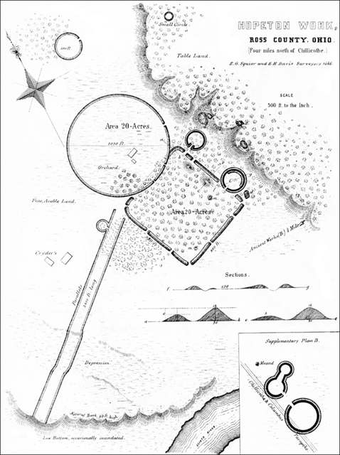
Photo: Ephraim George Squier and Edwin Hamilton Davis, Ancient Monuments of the Mississippi Valley, public domain · Wikimedia Commons
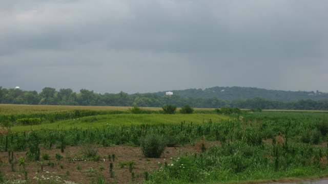
Photo: Nyttend, public domain · Wikimedia Commons
Local history sources: en.wikipedia.org · en.wikipedia.org · genealogytrails.com · en.wikipedia.org · en.wikipedia.org · en.wikipedia.org · commons.wikimedia.org · commons.wikimedia.org · archive.org · archive.org · ross.ohgenweb.org
Historic places
1 place in Springfield Township, Ross County on the National Register of Historic Places. Press a pin or a name for its whole record.
-
Wesley ChapelBuilding · Hopetown · listed 1979
- Address
- Off U.S. 23
- Where
- Hopetown, Ross County · ZIP 45601
- What it is
- Building
- Listed on the National Register
- 1979
- NRIS reference number
- 79001936
- Coordinates
- 39.37777, -82.97279
National Register file (NPS) ↗ Search Wikipedia ↗ Street map and directions ↗ On the Cracked Buckeye map
Source: National Park Service, National Register of Historic Places point file. The listing year is shown where NPS's certification date agrees with the listing's reference number. Listing recognizes significance; it does not restrict a private owner.
Water
Seven active wells in the Scioto Buried River Valley Aquifer (the CCR's own name) serving the city well field near Yoctangee Park. The City of Chillicothe also has emergency connections with Ross County Water Company and the Chillicothe Correctional Institution; neither was used in 2025. The water here
- Chillicothe City51% of residentsScioto Buried Valley Aquifer (Teays Valley system) wells
- Ross County Water Co. Inc49% of residentsTeays Valley Aquifer (buried valley groundwater)
- Kingston Village1% of residentsTeays Valley Aquifer (buried valley groundwater)
Hospitals, fire stations and more
Inside Springfield Township, Ross County's boundary: 3 fire and EMS stations, 1 high-hazard dam, 2 poor-rated bridges, 1 Toxics Release Inventory facility, 1 spill case and 1 mound or earthwork. Press a pin or a name for its whole record and its source.
Fire and EMS stations (3)
-
Springfield Township Volunteer Fire Department Station 1Chillicothe
- Address
- 3140 Lick Run Road, Chillicothe, OH 45601
- Coordinates
- 39.35073, -82.90910
USGS National Map structures (source) ↗ Street map and directions ↗
-
Springfield Township Volunteer Fire Department Station 2Chillicothe
- Address
- 60 Firehouse Drive, Chillicothe, OH 45601
- Coordinates
- 39.30962, -82.91342
USGS National Map structures (source) ↗ Street map and directions ↗
-
Springfield Township Volunteer Fire Department Station 3Chillicothe
- Address
- 3050 Marietta Road, Chillicothe, OH 45601
- Coordinates
- 39.38406, -82.95304
USGS National Map structures (source) ↗ Street map and directions ↗
Source: USGS National Map structures (most Ohio records last updated 2019 to 2022), checked against the Columbus and Cleveland station lists. The department that answers a call is set by jurisdiction and mutual aid, not by distance.
High-hazard dams (1)
-
Ross Lake Dam PoorLick Run · condition: poor
- Hazard class
- High: a failure would probably cost a life
- Condition
- Poor (assessed 11/16/2023)
- River or stream
- Lick Run
- Purpose
- Recreation
- Type
- Earth
- Height
- 48 ft
- Storage
- 4,350 acre-feet
- Completed
- 1967
- Owner type
- State
- County
- Ross County
- Nearest town (NID)
- Schrader
- Last inspection
- 11/14/2022
- Emergency action plan
- Yes
- NID ID
- OH00443
National Inventory of Dams record ↗ National Inventory of Dams (source) ↗ Street map and directions ↗
Source: U.S. Army Corps of Engineers National Inventory of Dams, August 2026. "High hazard" rates what a failure would cost downstream, not how likely one is; the condition is the state's assessment.
Bridges rated poor (2)
-
Chapel Creek Rd over Chapel CreekPoor · built 1965
- Condition
- Poor: a deck, superstructure, substructure or culvert rated 4 or below on the 0 to 9 scale
- What it is
- Bridge
- Built
- 1965
- Length
- 9 ft
- Owner
- County
- Vehicles a day
- 75
- Coordinates
- 39.38750, -82.86581
National Bridge Inventory (source) ↗ Street map and directions ↗
-
Charleston Pike over Csx RailroadPoor · built 1927
- Condition
- Poor: a deck, superstructure, substructure or culvert rated 4 or below on the 0 to 9 scale
- What it is
- Bridge
- Built
- 1927
- Length
- 59 ft
- Owner
- County
- Vehicles a day
- 2,231
- Coordinates
- 39.31871, -82.91529
National Bridge Inventory (source) ↗ Street map and directions ↗
Source: FHWA National Bridge Inventory 2025. "Poor" means one major part rated 4 or below on the 0 to 9 scale; it calls for repair, not closing, unless the state posts or closes the bridge.
Facilities reporting toxic releases (1)
-
Us Army National Guard Range - Camp ShermanToxics Release Inventory · Chillicothe
- Address
- 2154 Narrows Rd, Chillicothe, OH 45601
- County
- Ross County County
- Status
- Reports to the Toxics Release Inventory
- Federal facility
- Yes
- EPA program ID
- 4560WSRMYN2154N
- EPA registry ID
- 110060261513
EPA facility record ↗ EPA Facility Registry Service (source) ↗ Street map and directions ↗
Source: EPA Facility Registry Service, Toxics Release Inventory reporters. Reporting a release is required of large users of listed chemicals; it is not by itself a violation.
Spills reported since 2021 (1)
-
Asbestos2021-05-10 · Springfield Twp
- Reported
- 2021-05-10
- What spilled
- Asbestos
- Where
- Springfield Twp, Ross County
- Ohio EPA district office
- SEDO
- Ohio EPA case number
- 2105EPA0000655
Ohio EPA spill reports (source) ↗ Street map and directions ↗
Source: Ohio EPA emergency response spill reports, 2021 to September 2026, one point per case where Ohio EPA placed it. A report is what the caller or responder recorded; amounts are often blank or estimated.
Mounds and earthworks (1)
-
Hopeton EarthworksEarthwork · Hopewell culture (Middle Woodland
- What it is
- Earthwork
- Age
- Hopewell culture (Middle Woodland, roughly 100 BC - AD 500)
- Where
- Scioto River terrace, Springfield Township, about 1 mile east of the Mound City group, now a detached unit of Hopewell Culture National Historical Park
- County
- Ross County
- Named in the history of
- Springfield Township, Ross County, Union Township, Ross County
- Map point
- from the site's Wikipedia article
Wikipedia article (point and source) ↗ Street map and directions ↗
Many mounds stand on private land; visit only those open to the public.
Source: the History records' native sites, each placed by its own Wikipedia article; sites no article places are named on the History card but not pinned.
Its ZIP codes
Each ZIP code that touches Springfield Township, Ross County, with the share of its residents who live here and the same headline figures as the ZIP page.
| ZIP | Share | Water | Radon | Home value | Schools | Flood |
|---|---|---|---|---|---|---|
| 45601 Chillicothe | 4% | Seven active wells in the Scioto Buried River Valley Aquifer (the CCR's own name) serving the city well field near Yoctangee Park. The City of Chillicothe also has emergency connections with Ross County Water Company and the Chillicothe Correctional Institution; neither was used in 2025. | 6.3 pCi/L average radon | Median year built 1972 | Chillicothe City · 3 stars overall | 2.9% of residents in the 1% floodplain |
Local government
Who holds office in Springfield Township, Ross County, how its elections and ballot issues came out, and the state auditor's record.
Ballot issues
| Date | Issue | For | Against | Result |
|---|---|---|---|---|
| 2022-11-08 | Issue: Springfield Township | 679 | 241 | Passed (73.8% for) |
Auditor of State record
- No fiscal caution, watch or emergency on the Auditor of State's lists.
- Financial Audit, 2024, released 2025-09-23
- Financial Audit, 2022 to 2023, released 2024-08-20
The county
Ross County: 10 ZIP codes, 25 cities, villages and townships, 77,708 people.
Nearby places
Quick answers
What county is Springfield Township, Ohio in?
Springfield Township, Ross County is a township in Ross County, Ohio, with 2,559 residents.
When was Springfield Township, Ohio founded?
Springfield Township, Ross County was settled c. 1798. Founders on record: Early Virginia Military District land claimants; the Orr family, Leonard Neff, John Stauffer and others among them. Source
What ZIP code is Springfield Township, Ohio?
Most of Springfield Township, Ross County is in ZIP code 45601.
Where does Springfield Township, Ohio get its water?
The main water source for Springfield Township, Ross County (Chillicothe City): Seven active wells in the Scioto Buried River Valley Aquifer (the CCR's own name) serving the city well field near Yoctangee Park. The City of Chillicothe also has emergency connections with Ross County Water Company and the Chillicothe Correctional Institution; neither was used in 2025.
Cite this page
Cite this page as:
Cracked Buckeye, "Springfield Township, Ross County", https://crackedbuckeye.com/place/springfield-township-ross-county/, built 2026-10-31, accessed [date].
How to cite · Report a correction · Built 2026-10-31
