Local events in Salisbury Township, Meigs County
Salisbury Township itself has 1 event posted in the next 90 days; the others here are within 20 miles. All local events in Salisbury Township, Meigs County
Checked October 20; the events page is refreshed daily.
How Salisbury Township, Meigs County began
Salisbury Township is one of the oldest civil divisions in Meigs County, organized January 11, 1805 by Gallia County's commissioners -- more than a decade before Meigs County itself existed -- when they abolished the earlier Kerr's Township. It sits on the Ohio River opposite Mason County, West Virginia, and today holds two of the county's largest villages within its borders: Middleport in the southwest and Pomeroy, the county seat, in the southeast. Rutland Township was carved out of Salisbury's territory in 1812, and the whole township transferred from Gallia to the new Meigs County in 1819. It had 5,512 residents in 2020, reflecting the river towns inside its boundary.
Incorporated January 11, 1805 (as Salisbury Township, Gallia County), by Gallia County commissioners, who abolished Kerr's Township to form it.
Where the name comes from
No source we found explains why the township was named Salisbury. It is the only township named Salisbury statewide in Ohio.
Before the town
No source we found documents a specific Native American village, camp, trail or burial site within Salisbury Township's own boundaries, apart from the Ohio River itself, long a travel corridor for Shawnee, Wyandot, Mingo (Seneca-Cayuga) and other nations, and Mason County, West Virginia, directly across the river from the township. This stretch of the Ohio Valley lay within territory the United States treated as ceded by the Treaty of Fort McIntosh (1785) and Treaty of Fort Harmar (1789) -- agreements the Shawnee and Miami disputed -- and the dispute was not settled to the Americans' satisfaction until the Treaty of Greenville in 1795. The Mound Cemetery Mound, an Adena-era burial mound sometimes associated with this ZIP code area in records, is documented by name and by its own National Register listing as standing in neighboring Chester Township, north of the village of Chester, not within Salisbury Township; it is excluded here for that reason.
Nations recorded here: Shawnee, Wyandot, Mingo (Seneca-Cayuga).
Timeline
- — Salisbury Township is formed and organized by Gallia County commissioners on January 11, replacing the earlier Kerr's Township.
- — Rutland Township is partitioned out of Salisbury Township's territory and organized separately.
- — Salisbury Township transfers from Gallia County into the newly formed Meigs County.
- — Pomeroy, on the township's southeastern river frontage, is incorporated as a village.
- — Pomeroy becomes the Meigs County seat, moved from Chester Township; it remains the county seat today.
- — Pomeroy's population reaches roughly 5,000 at the height of the county's coal and salt boom, supporting steel mills, breweries and an organ factory.
- — The Pomeroy Historic District, within the township's boundary at Pomeroy, is listed on the National Register of Historic Places; a boundary increase was added later.
- — Salisbury Township's population is recorded at 5,512, reflecting the villages of Middleport and Pomeroy within its borders.
Stories
A township older than its own county
Salisbury Township's paperwork predates Meigs County by fourteen years. It was organized on January 11, 1805, by the commissioners of Gallia County -- the county Meigs was later carved out of -- when they dissolved an earlier, short-lived division called Kerr's Township and redrew the line. For its first fourteen years Salisbury Township belonged to Gallia County's government at Gallipolis, only transferring into the new Meigs County when the state legislature created it in 1819. In between, in 1812, the township lost a large piece of its own territory when Rutland Township was partitioned off to its west.
The courthouse in the cliff
When Meigs County moved its seat of government from Chester to Pomeroy in 1841, it moved into a river town shaped by coal. Coal mining around Pomeroy had begun in 1819, and Valentine B. Horton, the son-in-law of the town's namesake Samuel Pomeroy, built the mines into a major industry and used the coal itself to boil down brine from deep wells discovered near the river in 1848, launching a salt-making business that ran for well over a century. By 1870 Pomeroy held close to 5,000 people and a full complement of Victorian-era industry -- steel mills, breweries, even an organ factory. The county courthouse the town built reflects the cramped, hilly riverfront site: it is built directly into a cliffside, with three stories each opening at ground level on a different side of the hill, a design distinctive enough to be featured in Ripley's Believe It or Not!
Photographs
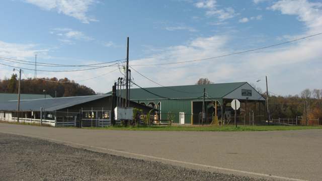
Photo: Nyttend, public domain · Wikimedia Commons
Local history sources: en.wikipedia.org · en.wikipedia.org · en.wikipedia.org · en.wikipedia.org · en.wikipedia.org · en.wikipedia.org · commons.wikimedia.org
Water
Groundwater wells (2 wells) The water here
- Pomeroy Village38% of residentsGroundwater wells (2 wells)
- Leading Creek Conservancy District36% of residentsGroundwater wells (4 wells)
- Middleport Village25% of residentsGroundwater wells (3 wells)
- Syracuse Village2% of residentsGroundwater wells (2 wells)
Hospitals, fire stations and more
Inside Salisbury Township, Meigs County's boundary: 1 health center, 2 public schools, 1 poor-rated bridge, 1 museum, 1 public charging site, 4 shale and injection wells and 4 spill cases. Press a pin or a name for its whole record and its source.
Community health centers (1)
-
Hopewell Health Centers - PomeroyHealth center · Pomeroy
- Run by
- a federally qualified health center
- Setting
- Clinic
- City
- Pomeroy
- Coordinates
- 39.05644, -82.01441
Find a Health Center (HRSA) ↗ HRSA data (source) ↗ Street map and directions ↗
Source: HRSA health center service delivery sites, active, September 2026 (school-based sites left out). Health centers see patients whether or not they have insurance, with fees on a sliding scale.
Public schools (2)
-
Meigs High School2 of 5 stars · Pomeroy
- Address
- 42091 Pomeroy Pike, Pomeroy, OH 45769
- School district
- Meigs Local School District
- Kind (NCES)
- Regular School
- Students, 2023-24
- 518
- Teachers (full-time equivalent)
- 37
- Report card, 2025-26
- 2 of 5 stars
- Performance index
- 61.2%
- Four-year graduation rate
- 82.4%
- Ohio building IRN
- 024117
- NCES school ID
- 390485203284
NCES school record ↗ Ohio School Report Card ↗ Street map and directions ↗
-
Meigs Middle School4 of 5 stars · Pomeroy
- Address
- 42353 Charles Chancey Dr, Pomeroy, OH 45769
- School district
- Meigs Local School District
- Kind (NCES)
- Regular School
- Students, 2023-24
- 337
- Teachers (full-time equivalent)
- 21
- Report card, 2025-26
- 4 of 5 stars
- Performance index
- 64%
- Ohio building IRN
- 062307
- NCES school ID
- 390485203285
NCES school record ↗ Ohio School Report Card ↗ Street map and directions ↗
Source: NCES EDGE public school locations 2024-25 and Common Core of Data 2023-24 (type, students, teachers); Ohio School Report Cards 2025-26 (Department of Education and Workforce), matched by name within the district.
Bridges rated poor (1)
-
TR 655 Snowden over Thomas ForkPoor · built 1961
- Condition
- Poor: a deck, superstructure, substructure or culvert rated 4 or below on the 0 to 9 scale
- What it is
- Bridge
- Built
- 1961
- Length
- 17 ft
- Owner
- County
- Vehicles a day
- 15
- Coordinates
- 39.02567, -82.07188
National Bridge Inventory (source) ↗ Street map and directions ↗
Source: FHWA National Bridge Inventory 2025. "Poor" means one major part rated 4 or below on the 0 to 9 scale; it calls for repair, not closing, unless the state posts or closes the bridge.
Museums, historical societies, gardens and zoos (1)
-
Meigs County Pioneer And Historical SocietyHistorical society · Pomeroy
- What it is
- Historical society
- City
- Pomeroy
- Coordinates
- 39.07000, -82.03699
Search Wikipedia ↗ IMLS Museum Data Files (source) ↗ Street map and directions ↗
The museum list is IMLS's 2018 file; a museum may have closed or moved since.
Source: IMLS Museum Data Files, 2018.
Public EV charging (1)
-
MARK PORTER 1 MARK PORTER 1 DC fast1 DC fast · Pomeroy
- Address
- 42411 Charles Chancey Dr, Pomeroy, OH 45769
- Ports
- 1 DC fast
- Plugs
- CCS, CHAdeMO
- Network
- ChargePoint Network
- Hours
- 24 hours daily
- Phone
- 888-758-4389
Station Locator (NREL) ↗ Alternative Fuels Data Center (source) ↗ Street map and directions ↗
Source: NREL Alternative Fuels Data Center station list (May 2026), public and open stations, the posts at one address counted as one site.
Shale and injection wells (4)
-
Edith Forrest {Swiw#3} 4 InjectionInjection well (Class II)
- What it is
- Injection well (Class II)
- Operator
- J D Drilling Company
- County
- Meigs County
- API well number
- 34105227390000
- Coordinates
- 39.01963, -82.08508
ODNR oil and gas wells (source) ↗ Street map and directions ↗
-
Harold & Penny Brinker {Swiw#5} 2 InjectionInjection well (Class II)
- What it is
- Injection well (Class II)
- Operator
- J D Drilling Company
- County
- Meigs County
- API well number
- 34105231850000
- Coordinates
- 39.04082, -82.08450
ODNR oil and gas wells (source) ↗ Street map and directions ↗
-
Jaymar(Swiw#10) 2-D InjectionInjection well (Class II)
- What it is
- Injection well (Class II)
- Operator
- On Point Petroleum, Llc
- County
- Meigs County
- API well number
- 34105234330000
- Coordinates
- 39.02293, -82.06436
ODNR oil and gas wells (source) ↗ Street map and directions ↗
-
Woodyard Timothy (Swiw #7) 1-C InjectionInjection well (Class II)
- What it is
- Injection well (Class II)
- Operator
- On Point Petroleum, Llc
- County
- Meigs County
- API well number
- 34105233190000
- Coordinates
- 39.06277, -82.05612
ODNR oil and gas wells (source) ↗ Street map and directions ↗
Source: ODNR Division of Oil and Gas Resources well inventory (September 2026): drilled Utica, Marcellus and horizontal wells and Class II injection wells not plugged. Older vertical wells are on the full map.
Spills reported since 2021 (4)
-
Oil Petroleum Not Otherwise Specified (Nos) Reached water2023-03-15 · Salisbury Twp
- Reported
- 2023-03-15
- What spilled
- Oil Petroleum Not Otherwise Specified (Nos)
- Reached a waterway
- 99 - Unnamed
- Where
- Salisbury Twp, Meigs County
- Ohio EPA district office
- SEDO
- Ohio EPA case number
- 2303EPA0000388
Ohio EPA spill reports (source) ↗ Street map and directions ↗
-
Material Green Reached water2023-02-18 · Salisbury Twp
- Reported
- 2023-02-18
- What spilled
- Material Green
- Reached a waterway
- 53 - Forest Run
- Where
- Salisbury Twp, Meigs County
- Ohio EPA district office
- SEDO
- Ohio EPA case number
- 2302EPA0000258
Ohio EPA spill reports (source) ↗ Street map and directions ↗
-
Oil Crude Reached water2026-03-09 · Salisbury Twp
- Reported
- 2026-03-09
- What spilled
- Oil Crude
- Largest amount reported
- 42 gallons
- Reached a waterway
- 53 - Wolfpen Run
- Where
- Salisbury Twp, Meigs County
- Ohio EPA district office
- SEDO
- Ohio EPA case number
- 2603EPA0000335
Ohio EPA spill reports (source) ↗ Street map and directions ↗
-
Brine Oil And Gas Related Reached water2026-01-02 · Null
- Reported
- 2026-01-02
- What spilled
- Brine Oil And Gas Related
- Reached a waterway
- 53 - Thomas Fork
- Where
- Null, Meigs County
- Ohio EPA district office
- SEDO
- Ohio EPA case number
- 2601EPA0000003
Ohio EPA spill reports (source) ↗ Street map and directions ↗
Source: Ohio EPA emergency response spill reports, 2021 to September 2026, one point per case where Ohio EPA placed it. A report is what the caller or responder recorded; amounts are often blank or estimated.
Its ZIP codes
Each ZIP code that touches Salisbury Township, Meigs County, with the share of its residents who live here and the same headline figures as the ZIP page.
| ZIP | Share | Water | Radon | Home value | Schools | Flood |
|---|---|---|---|---|---|---|
| 45769 Pomeroy | 21% | Groundwater wells (2 wells) | Too few radon tests | Parcel list only | Meigs Local · 2.5 stars overall | 4.5% of residents in the 1% floodplain |
| 45760 Middleport | 11% | Municipal wellfield of three wells feeding the village's water treatment plant (recorded by EPA as WTP 2 and WTP 3 units at one site) | Too few radon tests | Median year built 1982 | Meigs Local · 2.5 stars overall | 46% of residents in the 1% floodplain |
| 45620 Cheshire Township and Cheshire | 9% | Mostly private wells | Too few radon tests | Median year built 1971 | Gallia County Local · 3 stars overall | 18% of residents in the 1% floodplain |
Local government
Who holds office in Salisbury Township, Meigs County, how its elections and ballot issues came out, and the state auditor's record.
Money issues on the ballot since 2020: 1 of 3 passed; of those asking for new or higher taxes, 1 of 2.
Ballot issues
| Date | Issue | For | Against | Result |
|---|---|---|---|---|
| 2021-11-02 | Issue: Salisbury Twp. Replacement Fire Levy - 1mill/5yrs (1.0 mills, replacement) | 298 | 287 | Passed (50.94% for) |
| 2021-11-02 | Issue: Salisbury Twp. Additional Cemetery Levy - 0.5mill/5yrs (0.5 mills, additional) | 115 | 118 | Failed (49.36% for) |
| 2020-11-03 | Issue: Proposed Tax Levy - Renewal - Salisbury Township - Cemetery Maintenance - .5 mills 5 years (0.5 mills, renewal) | 1,003 | 1,219 | Failed (45.14% for) |
Elections for office
| Date | Office | Candidates and votes |
|---|---|---|
| 2021-11-02 | Township Trustee | Robert E. Ball 361, 42.72%; Bill E. Spaun 371, 43.91%; Write-In: Wallace Hatfield 106, 12.54% |
| 2019-11-05 | Township Trustee | John Hood 850, 100.0% |
| 2019-11-05 | Township Fiscal Officer | James William Durst 757, 100.0% |
Winners in bold. Results from the county board of elections' official canvass unless marked.
Auditor of State record
- No fiscal caution, watch or emergency on the Auditor of State's lists.
- Financial Audit, 2022 to 2023, released 2025-07-31
The county
Meigs County: 12 ZIP codes, 16 cities, villages and townships, 20,189 people.
Nearby places
Quick answers
What county is Salisbury Township, Ohio in?
Salisbury Township, Meigs County is a township in Meigs County, Ohio, with 1,731 residents.
When was Salisbury Township, Ohio founded?
Salisbury Township, Meigs County was incorporated January 11, 1805 (as Salisbury Township, Gallia County). Founders on record: Gallia County commissioners, who abolished Kerr's Township to form it. Source
What ZIP code is Salisbury Township, Ohio?
Salisbury Township, Meigs County is served by ZIP codes 45769, 45760 and 45620; 45769 holds the largest share of its residents.
Where does Salisbury Township, Ohio get its water?
The main water source for Salisbury Township, Meigs County (Pomeroy Village): Groundwater wells (2 wells).
Cite this page
Cite this page as:
Cracked Buckeye, "Salisbury Township, Meigs County", https://crackedbuckeye.com/place/salisbury-township-meigs-county/, built 2026-10-31, accessed [date].
How to cite · Report a correction · Built 2026-10-31
