Local events in Benton Township, Monroe County
Nothing is posted yet for this township in the calendars we watch. What we watch, and what is on nearby
Know a calendar we should watch? Send the link
Checked October 20; the events page is refreshed daily.
How Benton Township, Monroe County began
Benton Township, organized March 27, 1851, was the last township erected by the Monroe County commissioners, formed only after the neighboring counties reorganized following Noble County's creation that same year. Its earliest settlers, though, arrived nearly half a century earlier: Isaac Brown and brothers Joseph and William Cline settled section 25 in 1804, and John Cline followed in 1805, having previously raised hemp for sale at Marietta while living in Virginia. The Cline family, tracing back to a German immigrant, George Cline, who served in the Revolutionary War, also appears among the founding settlers of neighboring Washington Township.
Settled 1804 (Isaac Brown, Joseph and William Cline), incorporated 1851-03-27 (township organized, the last erected in the county), by Monroe County commissioners.
Where the name comes from
The origin of the township name 'Benton' is not recorded.
Before the town
No Native American village, camp or mound is recorded for Benton Township. The area lay within the broader hunting and travel range of the Wyandot, Shawnee, Lenape (Delaware) and Mingo peoples before the Treaty of Greenville (1795), but no named site is recorded in the township.
Nations recorded here: Wyandot, Shawnee, Lenape (Delaware), Mingo (Seneca-Cayuga).
Timeline
- — Isaac Brown and brothers Joseph and William Cline settled section 25, among the earliest settlement in what became Benton Township.
- — John Cline arrived from Virginia, where he had raised and sold hemp at Marietta.
- — Mary Cline, daughter of Joseph and Sarah Cline, was born, the township's first recorded child.
- — Solomon Tice married Rosa Cline, the township's first recorded marriage.
- — A child, Johnny Cline, son of William and Polly Cline, died about two years after the first settlement, thought to have been bitten in the night by a poisonous snake.
- — Benton Township was formally organized, the last township erected by the county commissioners, comprising 24 sections in a 6-by-4 grid.
- — Benton Township counted 937 residents.
- — Professor Andrews found a three-foot coal seam mined on Eli Eddy's land in section 11, and Muskingum Creek and its runs, Trail, Big Lick, Old Camp and Rock Camp, drained the broken township.
- — The Walter Ring House and Mill Site, on the north side of Township Road 575 at its crossing of the Little Muskingum River, was listed on the National Register of Historic Places.
- — The census counted 298 residents in the 22.6-square-mile township with no municipalities.
Stories
Johnny Cline and the snake
The first cabins in what became Benton Township were built by Isaac Brown and Joseph and William Cline in 1804, and John Cline entered the first Congress land in section 25 in 1805, paying with the proceeds of a hemp crop he had raised near Sistersville and sold at Marietta. Joseph and Sarah Cline's daughter Mary was born on April 5, 1805, and George and Christina Cline's daughter, also named Mary, the next day, and Solomon Tice married Rosa Cline in 1806. Two years or so after the first settlement a child, Johnny Cline, son of William and Polly Cline, died: he was believed to have been bitten in the night by a poisonous snake and was dead by the next morning. The elder George Cline, father of the Cline brothers, had come from Germany to Pennsylvania, fought in the Revolution and, after the settlement of Marietta, moved west to near what is now Grandview in Washington County.
Photographs
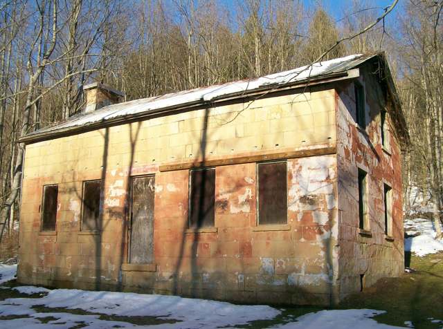
Photo: Bwsmith84, via Wikimedia Commons, CC BY 3.0 · Wikimedia Commons
Local history sources: monroe.ohgenweb.org · en.wikipedia.org · commons.wikimedia.org · archive.org · en.wikipedia.org
Water
Mostly private wells The water here
- Matamoras Village87% of residentsGroundwater wells (2 wells)
- Ohio and Lee Twp Water Authority12% of residentsGroundwater wells (2 wells)
- Monroe Water Systems0% of residentsGroundwater wells (5 wells)
Hospitals, fire stations and more
Inside Benton Township, Monroe County's boundary: 1 poor-rated bridge and 17 shale and injection wells. Press a pin or a name for its whole record and its source.
Bridges rated poor (1)
-
Twp Rd 562 over Little Muskingum RiverPoor · built 1900
- Condition
- Poor: a deck, superstructure, substructure or culvert rated 4 or below on the 0 to 9 scale
- What it is
- Bridge
- Built
- 1900
- Length
- 37 ft
- Owner
- County
- Vehicles a day
- 209
- Coordinates
- 39.62396, -81.08649
National Bridge Inventory (source) ↗ Street map and directions ↗
Source: FHWA National Bridge Inventory 2025. "Poor" means one major part rated 4 or below on the 0 to 9 scale; it calls for repair, not closing, unless the state posts or closes the bridge.
Shale and injection wells (17)
-
Beachy 1UhHorizontal shale well
- What it is
- Horizontal shale well
- Drilled sideways
- Yes
- Operator
- Diversified Production Llc
- County
- Monroe County
- API well number
- 34111249500000
- Coordinates
- 39.61715, -81.10026
ODNR oil and gas wells (source) ↗ Street map and directions ↗
The point is the surface well head (the pad); a horizontal well runs a mile or more underground from it.
-
Beachy 2UhHorizontal shale well
- What it is
- Horizontal shale well
- Drilled sideways
- Yes
- Operator
- Diversified Production Llc
- County
- Monroe County
- API well number
- 34111249510000
- Coordinates
- 39.61713, -81.10019
ODNR oil and gas wells (source) ↗ Street map and directions ↗
The point is the surface well head (the pad); a horizontal well runs a mile or more underground from it.
-
Dynamite North 1 UhUtica shale well
- What it is
- Utica shale well
- Drilled sideways
- Yes
- Operator
- Diversified Production Llc
- County
- Monroe County
- API well number
- 34111249450000
- Coordinates
- 39.59248, -81.12795
ODNR oil and gas wells (source) ↗ Street map and directions ↗
The point is the surface well head (the pad); a horizontal well runs a mile or more underground from it.
-
Dynamite South 3 UhUtica shale well
- What it is
- Utica shale well
- Drilled sideways
- Yes
- Operator
- Diversified Production Llc
- County
- Monroe County
- API well number
- 34111249460000
- Coordinates
- 39.59244, -81.12800
ODNR oil and gas wells (source) ↗ Street map and directions ↗
The point is the surface well head (the pad); a horizontal well runs a mile or more underground from it.
-
Forni 1UhUtica shale well
- What it is
- Utica shale well
- Drilled sideways
- Yes
- Operator
- Diversified Production Llc
- County
- Monroe County
- API well number
- 34111248500000
- Coordinates
- 39.58350, -81.11397
ODNR oil and gas wells (source) ↗ Street map and directions ↗
The point is the surface well head (the pad); a horizontal well runs a mile or more underground from it.
-
Forni 3 UhUtica shale well
- What it is
- Utica shale well
- Drilled sideways
- Yes
- Operator
- Diversified Production Llc
- County
- Monroe County
- API well number
- 34111248480000
- Coordinates
- 39.58355, -81.11385
ODNR oil and gas wells (source) ↗ Street map and directions ↗
The point is the surface well head (the pad); a horizontal well runs a mile or more underground from it.
-
Forni 4 UhUtica shale well
- What it is
- Utica shale well
- Drilled sideways
- Yes
- Operator
- Diversified Production Llc
- County
- Monroe County
- API well number
- 34111248470000
- Coordinates
- 39.58358, -81.11379
ODNR oil and gas wells (source) ↗ Street map and directions ↗
The point is the surface well head (the pad); a horizontal well runs a mile or more underground from it.
-
Forni 5UhUtica shale well
- What it is
- Utica shale well
- Drilled sideways
- Yes
- Operator
- Diversified Production Llc
- County
- Monroe County
- API well number
- 34111249280000
- Coordinates
- 39.58347, -81.11404
ODNR oil and gas wells (source) ↗ Street map and directions ↗
The point is the surface well head (the pad); a horizontal well runs a mile or more underground from it.
-
Forni 6UhUtica shale well
- What it is
- Utica shale well
- Drilled sideways
- Yes
- Operator
- Diversified Production Llc
- County
- Monroe County
- API well number
- 34111249290000
- Coordinates
- 39.58345, -81.11410
ODNR oil and gas wells (source) ↗ Street map and directions ↗
The point is the surface well head (the pad); a horizontal well runs a mile or more underground from it.
-
Harry Cisler 1UhUtica shale well
- What it is
- Utica shale well
- Drilled sideways
- Yes
- Operator
- Diversified Production Llc
- County
- Monroe County
- API well number
- 34111249780000
- Coordinates
- 39.58432, -81.08722
ODNR oil and gas wells (source) ↗ Street map and directions ↗
The point is the surface well head (the pad); a horizontal well runs a mile or more underground from it.
-
Harry Cisler 2UhUtica shale well
- What it is
- Utica shale well
- Drilled sideways
- Yes
- Operator
- Diversified Production Llc
- County
- Monroe County
- API well number
- 34111249800000
- Coordinates
- 39.58432, -81.08715
ODNR oil and gas wells (source) ↗ Street map and directions ↗
The point is the surface well head (the pad); a horizontal well runs a mile or more underground from it.
-
Harry Cisler 3UhUtica shale well
- What it is
- Utica shale well
- Drilled sideways
- Yes
- Operator
- Diversified Production Llc
- County
- Monroe County
- API well number
- 34111249760000
- Coordinates
- 39.58432, -81.08708
ODNR oil and gas wells (source) ↗ Street map and directions ↗
The point is the surface well head (the pad); a horizontal well runs a mile or more underground from it.
-
Harry Cisler 4UhUtica shale well
- What it is
- Utica shale well
- Drilled sideways
- Yes
- Operator
- Diversified Production Llc
- County
- Monroe County
- API well number
- 34111249770000
- Coordinates
- 39.58432, -81.08701
ODNR oil and gas wells (source) ↗ Street map and directions ↗
The point is the surface well head (the pad); a horizontal well runs a mile or more underground from it.
-
Harry Cisler 5UhUtica shale well
- What it is
- Utica shale well
- Drilled sideways
- Yes
- Operator
- Diversified Production Llc
- County
- Monroe County
- API well number
- 34111249790000
- Coordinates
- 39.58432, -81.08693
ODNR oil and gas wells (source) ↗ Street map and directions ↗
The point is the surface well head (the pad); a horizontal well runs a mile or more underground from it.
-
Pool 1UhUtica shale well
- What it is
- Utica shale well
- Drilled sideways
- Yes
- Operator
- Diversified Production Llc
- County
- Monroe County
- API well number
- 34111248230100
- Coordinates
- 39.59445, -81.10432
ODNR oil and gas wells (source) ↗ Street map and directions ↗
The point is the surface well head (the pad); a horizontal well runs a mile or more underground from it.
-
Pool 2 UhUtica shale well
- What it is
- Utica shale well
- Drilled sideways
- Yes
- Operator
- Diversified Production Llc
- County
- Monroe County
- API well number
- 34111248250000
- Coordinates
- 39.59440, -81.10430
ODNR oil and gas wells (source) ↗ Street map and directions ↗
The point is the surface well head (the pad); a horizontal well runs a mile or more underground from it.
-
Pool 3 UhUtica shale well
- What it is
- Utica shale well
- Drilled sideways
- Yes
- Operator
- Diversified Production Llc
- County
- Monroe County
- API well number
- 34111248240000
- Coordinates
- 39.59434, -81.10428
ODNR oil and gas wells (source) ↗ Street map and directions ↗
The point is the surface well head (the pad); a horizontal well runs a mile or more underground from it.
Source: ODNR Division of Oil and Gas Resources well inventory (September 2026): drilled Utica, Marcellus and horizontal wells and Class II injection wells not plugged. Older vertical wells are on the full map.
Its ZIP codes
Each ZIP code that touches Benton Township, Monroe County, with the share of its residents who live here and the same headline figures as the ZIP page.
| ZIP | Share | Water | Radon | Home value | Schools | Flood |
|---|---|---|---|---|---|---|
| 45767 Grandview Township and New Matamoras | 11% | Mostly private wells | 4.8 pCi/L average radon | Median year built 1960 | Frontier Local · 3 stars overall | 9.7% of residents in the 1% floodplain |
| 43946 Lee Township and Sardis | 2% | Mostly private wells | Too few radon tests | Median year built 1967 | Switzerland of Ohio Local · 3 stars overall | 14% of residents in the 1% floodplain |
The county
Washington County: 17 ZIP codes, 33 cities, villages and townships, 61,140 people.
Nearby places
Quick answers
What county is Benton Township, Ohio in?
Benton Township, Monroe County is a township in Washington County, Ohio, with 298 residents.
When was Benton Township, Ohio founded?
Benton Township, Monroe County was settled 1804 (Isaac Brown, Joseph and William Cline); incorporated 1851-03-27 (township organized, the last erected in the county). Founders on record: Monroe County commissioners. Source
How did Benton Township, Ohio get its name?
The origin of the township name 'Benton' is not recorded. Source
What ZIP code is Benton Township, Ohio?
Benton Township, Monroe County is served by ZIP codes 45767 and 43946; 45767 holds the largest share of its residents.
Where does Benton Township, Ohio get its water?
The main water source for Benton Township, Monroe County (Matamoras Village): Mostly private wells.
Cite this page
Cite this page as:
Cracked Buckeye, "Benton Township, Monroe County", https://crackedbuckeye.com/place/benton-township-monroe-county/, built 2026-10-31, accessed [date].
How to cite · Report a correction · Built 2026-10-31
