Local events in Millwood Township, Guernsey County
Nothing is posted for Millwood Township itself yet; here is what is on within 20 miles. All local events in Millwood Township, Guernsey County
Know a calendar we should watch? Send the link
Checked October 20; the events page is refreshed daily.
How Millwood Township, Guernsey County began
Millwood Township, in the southeastern corner of Guernsey County, was first settled in 1806 by Friends (Quakers) and other families from Pennsylvania, North Carolina, New Jersey and Maryland, and was organized about 1834. John Webster and his sons built a mill on Leatherwood Creek in 1807, and the village platted nearby in 1835 as Millwood, a name the county's 1911 history says did not come from the mill and whose origin is unknown, was later renamed Quaker City for the Friends around it. Salesville was platted in 1835 on the old Clay Pike and incorporated in 1878 (it disincorporated in 2015). The township is now a farming and sheep-raising township of 1,258 people (2020).
Settled 1806 (a Hall, first settler, began clearing on August 4; the Webster family arrived August 10), platted 1835 (Millwood, now Quaker City, platted February 18 by Jonah Smith; Salesville platted 1835 by George Brill), incorporated township organized c. 1834; Salesville incorporated 1878; Quaker City incorporated 1871 (Sarchet also gives 1836 for Millwood), by Friends (Quaker) families from Pennsylvania, North Carolina, New Jersey and Maryland; John Webster entered ten half-sections of land for his ten children.
Where the name comes from
Sarchet's 1911 county history records that John and William Webster built a mill on Leatherwood Creek in 1807 above the present Quaker City depot, and that the first village platted in the township (1835) was named Millwood; it says plainly that the Websters' mill did not give Millwood its name and that the real origin is unknown ('Who knows?'). Millwood was changed to Quaker City because the town stood in the midst of a large and thrifty settlement of Friends (Quakers).
Before the town
No site-specific Native American history for Millwood Township was found in the sources checked. The wider county was within the area ceded under the Treaty of Greenville (1795).
Timeline
- — On August 4, a Hall of the family that had come from North Carolina in 1805 began grubbing a tract on the northwest quarter of section 13, the first settlement in what is now Millwood Township; he spent his first night under a white oak.
- — On August 10, John Webster and his family arrived and entered ten half-sections of Congress land at the Steubenville land office, eighty acres for each of his ten children; the Baltimore & Ohio line later ran along the site of his double log house.
- — John and William Webster built a mill on Leatherwood Creek above the present Quaker City depot grounds; John Webster died about eighteen months after settling, aged fifty-seven.
- — The Friends settled near Quaker City, from Pennsylvania, North Carolina, New Jersey and Maryland, numbered fifty-nine persons.
- — The Friends' first meeting house was built on the hill east of Quaker City, after meetings in private houses; William Mott taught school there in 1821.
- — Settlers of several denominations near Salesville built a hewed-log meeting house on the hill above Leatherwood Creek, called the Temple, the start of church life in that part of the county.
- — Millwood Township was organized, twenty-four sections in the southeast corner of Guernsey County.
- — Jonah Smith filed the plat of Millwood (later Quaker City) on February 18, and George Brill platted Salesville the same year on the Clay Pike.
- — Isaac W. Hall, born in 1810 to the pioneer family, opened a store at Quaker City, then still called Millwood, and later founded its National Bank.
- — A store opened at Quaker City, spurring the village's growth (as reported by the village's Wikipedia article).
- — Quaker City was incorporated, with J. C. Steele as first mayor (1871-72); Sarchet elsewhere gives an earlier incorporation as Millwood in 1836, and the dates are not reconciled.
- — The Quaker City Independent was established by J. D. Olmstead & Sons; the Hill brothers took it over in 1882.
- — Salesville was incorporated as a village.
- — Quaker City counted 594 residents in the census, rising to 878 by 1900.
- — Spencer's Station was platted as a railroad station on the Baltimore & Ohio near Quaker City.
- — Quaker City had about one thousand people, a national bank, opera house, grist and planing mills, coal mines and natural gas piped from Noble County's Dudley field; Salesville had about 250.
- — The village of Salesville disincorporated and became a census-designated place.
- — Millwood Township had 1,258 residents; Quaker City itself had 379.
Stories
A night under a white oak
On August 4, 1806, a young Hall, newly of age and lately arrived from North Carolina with his father's family, took up the grubs on the northwest quarter of section 13 and began to prepare a cabin site. He spent his first night by the root of a white oak and built a scaffold nearby for a knife and fork, a pewter plate, one spoon, a pot and a skillet, a flitch of bacon, a loaf of bread and a sack of meal. His tray was half a buckeye log split and hollowed. Game was plentiful. His nearest neighbor was John Reed, who lived by the later high railroad trestle, and the next was Joseph Williams, five miles down the Leatherwood valley. Six days later John Webster arrived with ten children and entered land for all of them.
From Millwood to Quaker City
The Websters raised a mill on Leatherwood Creek in the summer of 1807, and when Jonah Smith platted the first village in 1835 he called it Millwood; the county history says the mill did not give the village that name, and its real origin is unknown. By then the neighborhood had belonged for a generation to Friends from Pennsylvania, North Carolina, New Jersey and Maryland, who counted fifty-nine persons in 1811 and had their first meeting house about 1812 on the hill east of town. Isaac W. Hall opened his store in 1839 and later founded the Quaker City National Bank; the town was incorporated under the Quaker name in 1871. By 1910 it had about a thousand people, an opera house, coal mines and gas piped from Noble County. The Leatherwood Dam, photographed in 1906, belongs to this water-powered past.
Jesse Cole's coffin
Jesse Cole, born near Reading, Pennsylvania, settled in Millwood Township in 1823 and, in his eighty-fourth year, told neighbors he intended to live to one hundred. After a bad illness at his bachelor cabin near Sarahsville a neighbor woman made him a shroud, which he kept; when he remarried he gave it to his new wife for safekeeping. About eight years before the Jeffersonian printed his story on August 20, 1885, he walked to Quaker City and ordered a plain walnut coffin, hauled it home on a sled, and set it in the loft of the loom house. Rumor said the family had burned it for kindling or filled it with dried apples; the newspaper assured readers there was no truth in either report.
Photographs
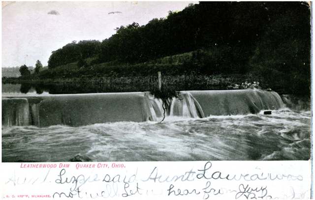
Photo: Columbus Metropolitan Library, via Digital Public Library of America / Ohio Digital Network, public domain · Wikimedia Commons
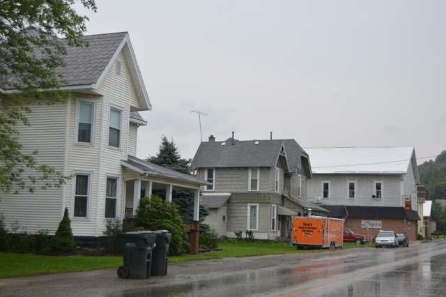
Photo: Wikimedia Commons contributor, public domain · Wikimedia Commons
Local history sources: en.wikipedia.org · en.wikipedia.org · archive.org · ohiogenealogyexpress.com · commons.wikimedia.org
Water
Mostly private wells The water here
- Quaker City100% of residentsBarnesville Reservoirs #1, #2 & Slope Creek Reservoir
Hospitals, fire stations and more
Inside Millwood Township, Guernsey County's boundary: 4 poor-rated bridges, 53 shale and injection wells and 4 spill cases. Press a pin or a name for its whole record and its source.
Bridges rated poor (4)
-
T49 Johnsons Mill over Stream Salt ForkPoor · built 1910
- Condition
- Poor: a deck, superstructure, substructure or culvert rated 4 or below on the 0 to 9 scale
- What it is
- Bridge
- Built
- 1910
- Length
- 9 ft
- Owner
- County
- Vehicles a day
- 60
- Coordinates
- 40.00863, -81.24700
National Bridge Inventory (source) ↗ Street map and directions ↗
-
Township Rd 9420 over Leatherwood CreekPoor · built 1920
- Condition
- Poor: a deck, superstructure, substructure or culvert rated 4 or below on the 0 to 9 scale
- What it is
- Bridge
- Built
- 1920
- Length
- 19 ft
- Owner
- County
- Vehicles a day
- 96
- Coordinates
- 39.96953, -81.32477
National Bridge Inventory (source) ↗ Street map and directions ↗
-
Township Rd 9435 over StreamPoor · built 1930
- Condition
- Poor: a deck, superstructure, substructure or culvert rated 4 or below on the 0 to 9 scale
- What it is
- Bridge
- Built
- 1930
- Length
- 11 ft
- Owner
- County
- Vehicles a day
- 96
- Coordinates
- 39.96378, -81.29105
National Bridge Inventory (source) ↗ Street map and directions ↗
-
Township Rd 9467 over Leatherwood CreekPoor · built 1983
- Condition
- Poor: a deck, superstructure, substructure or culvert rated 4 or below on the 0 to 9 scale
- What it is
- Bridge
- Built
- 1983
- Length
- 9 ft
- Owner
- County
- Vehicles a day
- 96
- Coordinates
- 39.95614, -81.25335
National Bridge Inventory (source) ↗ Street map and directions ↗
Source: FHWA National Bridge Inventory 2025. "Poor" means one major part rated 4 or below on the 0 to 9 scale; it calls for repair, not closing, unless the state posts or closes the bridge.
Shale and injection wells (53)
-
Anderson 1HuUtica shale well
- What it is
- Utica shale well
- Drilled sideways
- Yes
- Operator
- Inr Ohio Llc
- County
- Guernsey County
- API well number
- 34059242520100
- Coordinates
- 39.97485, -81.26933
ODNR oil and gas wells (source) ↗ Street map and directions ↗
The point is the surface well head (the pad); a horizontal well runs a mile or more underground from it.
-
Anderson 2HuUtica shale well
- What it is
- Utica shale well
- Drilled sideways
- Yes
- Operator
- Inr Ohio Llc
- County
- Guernsey County
- API well number
- 34059242550000
- Coordinates
- 39.97511, -81.26927
ODNR oil and gas wells (source) ↗ Street map and directions ↗
The point is the surface well head (the pad); a horizontal well runs a mile or more underground from it.
-
Anderson 3HuUtica shale well
- What it is
- Utica shale well
- Drilled sideways
- Yes
- Operator
- Inr Ohio Llc
- County
- Guernsey County
- API well number
- 34059242540000
- Coordinates
- 39.97487, -81.26923
ODNR oil and gas wells (source) ↗ Street map and directions ↗
The point is the surface well head (the pad); a horizontal well runs a mile or more underground from it.
-
Anderson 4HuUtica shale well
- What it is
- Utica shale well
- Drilled sideways
- Yes
- Operator
- Inr Ohio Llc
- County
- Guernsey County
- API well number
- 34059242560000
- Coordinates
- 39.97488, -81.26917
ODNR oil and gas wells (source) ↗ Street map and directions ↗
The point is the surface well head (the pad); a horizontal well runs a mile or more underground from it.
-
Anderson 5HuUtica shale well
- What it is
- Utica shale well
- Drilled sideways
- Yes
- Operator
- Inr Ohio Llc
- County
- Guernsey County
- API well number
- 34059242530000
- Coordinates
- 39.97489, -81.26912
ODNR oil and gas wells (source) ↗ Street map and directions ↗
The point is the surface well head (the pad); a horizontal well runs a mile or more underground from it.
-
Frank Miller Unit 2HUtica shale well
- What it is
- Utica shale well
- Drilled sideways
- Yes
- Operator
- Expand Operating Llc
- County
- Guernsey County
- API well number
- 34059243660000
- Coordinates
- 39.99501, -81.33861
ODNR oil and gas wells (source) ↗ Street map and directions ↗
The point is the surface well head (the pad); a horizontal well runs a mile or more underground from it.
-
Frank Miller Unit 4HUtica shale well
- What it is
- Utica shale well
- Drilled sideways
- Yes
- Operator
- Expand Operating Llc
- County
- Guernsey County
- API well number
- 34059243670000
- Coordinates
- 39.99505, -81.33856
ODNR oil and gas wells (source) ↗ Street map and directions ↗
The point is the surface well head (the pad); a horizontal well runs a mile or more underground from it.
-
Frank Miller Unit 6HUtica shale well
- What it is
- Utica shale well
- Drilled sideways
- Yes
- Operator
- Expand Operating Llc
- County
- Guernsey County
- API well number
- 34059243650000
- Coordinates
- 39.99508, -81.33850
ODNR oil and gas wells (source) ↗ Street map and directions ↗
The point is the surface well head (the pad); a horizontal well runs a mile or more underground from it.
-
Fritz Unit 3HUtica shale well
- What it is
- Utica shale well
- Drilled sideways
- Yes
- Operator
- Expand Operating Llc
- County
- Guernsey County
- API well number
- 34059243490000
- Coordinates
- 40.00837, -81.33331
ODNR oil and gas wells (source) ↗ Street map and directions ↗
The point is the surface well head (the pad); a horizontal well runs a mile or more underground from it.
-
Fritz Unit 5HUtica shale well
- What it is
- Utica shale well
- Drilled sideways
- Yes
- Operator
- Expand Operating Llc
- County
- Guernsey County
- API well number
- 34059243480100
- Coordinates
- 40.00842, -81.33329
ODNR oil and gas wells (source) ↗ Street map and directions ↗
The point is the surface well head (the pad); a horizontal well runs a mile or more underground from it.
-
Fritz Unit 7HUtica shale well
- What it is
- Utica shale well
- Drilled sideways
- Yes
- Operator
- Expand Operating Llc
- County
- Guernsey County
- API well number
- 34059243470000
- Coordinates
- 40.00847, -81.33326
ODNR oil and gas wells (source) ↗ Street map and directions ↗
The point is the surface well head (the pad); a horizontal well runs a mile or more underground from it.
-
Great Scott 3HUtica shale well
- What it is
- Utica shale well
- Drilled sideways
- Yes
- Operator
- Expand Operating Llc
- County
- Guernsey County
- API well number
- 34059244940000
- Coordinates
- 39.99518, -81.33839
ODNR oil and gas wells (source) ↗ Street map and directions ↗
The point is the surface well head (the pad); a horizontal well runs a mile or more underground from it.
-
Hall 10HuUtica shale well
- What it is
- Utica shale well
- Drilled sideways
- Yes
- Operator
- Inr Ohio Llc
- County
- Guernsey County
- API well number
- 34059243520000
- Coordinates
- 39.99173, -81.26003
ODNR oil and gas wells (source) ↗ Street map and directions ↗
The point is the surface well head (the pad); a horizontal well runs a mile or more underground from it.
-
Hall 12HuUtica shale well
- What it is
- Utica shale well
- Drilled sideways
- Yes
- Operator
- Inr Ohio Llc
- County
- Guernsey County
- API well number
- 34059243510000
- Coordinates
- 39.99176, -81.25999
ODNR oil and gas wells (source) ↗ Street map and directions ↗
The point is the surface well head (the pad); a horizontal well runs a mile or more underground from it.
-
Hall 2HuUtica shale well
- What it is
- Utica shale well
- Drilled sideways
- Yes
- Operator
- Inr Ohio Llc
- County
- Guernsey County
- API well number
- 34059243560000
- Coordinates
- 39.99160, -81.26016
ODNR oil and gas wells (source) ↗ Street map and directions ↗
The point is the surface well head (the pad); a horizontal well runs a mile or more underground from it.
-
Hall 4HuUtica shale well
- What it is
- Utica shale well
- Drilled sideways
- Yes
- Operator
- Inr Ohio Llc
- County
- Guernsey County
- API well number
- 34059243550000
- Coordinates
- 39.99163, -81.26013
ODNR oil and gas wells (source) ↗ Street map and directions ↗
The point is the surface well head (the pad); a horizontal well runs a mile or more underground from it.
-
Hall 6HuUtica shale well
- What it is
- Utica shale well
- Drilled sideways
- Yes
- Operator
- Inr Ohio Llc
- County
- Guernsey County
- API well number
- 34059243540000
- Coordinates
- 39.99166, -81.26010
ODNR oil and gas wells (source) ↗ Street map and directions ↗
The point is the surface well head (the pad); a horizontal well runs a mile or more underground from it.
-
Hall 8HuUtica shale well
- What it is
- Utica shale well
- Drilled sideways
- Yes
- Operator
- Inr Ohio Llc
- County
- Guernsey County
- API well number
- 34059243530000
- Coordinates
- 39.99170, -81.26006
ODNR oil and gas wells (source) ↗ Street map and directions ↗
The point is the surface well head (the pad); a horizontal well runs a mile or more underground from it.
-
Hayes Unit 2HUtica shale well
- What it is
- Utica shale well
- Drilled sideways
- Yes
- Operator
- Expand Operating Llc
- County
- Guernsey County
- API well number
- 34059243270000
- Coordinates
- 39.99756, -81.33191
ODNR oil and gas wells (source) ↗ Street map and directions ↗
The point is the surface well head (the pad); a horizontal well runs a mile or more underground from it.
-
Hayes Unit 4HUtica shale well
- What it is
- Utica shale well
- Drilled sideways
- Yes
- Operator
- Expand Operating Llc
- County
- Guernsey County
- API well number
- 34059243280000
- Coordinates
- 39.99751, -81.33191
ODNR oil and gas wells (source) ↗ Street map and directions ↗
The point is the surface well head (the pad); a horizontal well runs a mile or more underground from it.
-
Hayes Unit 6HUtica shale well
- What it is
- Utica shale well
- Drilled sideways
- Yes
- Operator
- Expand Operating Llc
- County
- Guernsey County
- API well number
- 34059243260000
- Coordinates
- 39.99745, -81.33191
ODNR oil and gas wells (source) ↗ Street map and directions ↗
The point is the surface well head (the pad); a horizontal well runs a mile or more underground from it.
-
Hayes Unit 8HUtica shale well
- What it is
- Utica shale well
- Drilled sideways
- Yes
- Operator
- Expand Operating Llc
- County
- Guernsey County
- API well number
- 34059243250000
- Coordinates
- 39.99740, -81.33191
ODNR oil and gas wells (source) ↗ Street map and directions ↗
The point is the surface well head (the pad); a horizontal well runs a mile or more underground from it.
-
Hd Mcclain 28-9-7 10HUtica shale well
- What it is
- Utica shale well
- Drilled sideways
- Yes
- Operator
- Eog Ohio, Llc
- County
- Guernsey County
- API well number
- 34059244510000
- Coordinates
- 40.01104, -81.31345
ODNR oil and gas wells (source) ↗ Street map and directions ↗
The point is the surface well head (the pad); a horizontal well runs a mile or more underground from it.
-
Hd Mcclain 28-9-7 1HUtica shale well
- What it is
- Utica shale well
- Drilled sideways
- Yes
- Operator
- Eog Ohio, Llc
- County
- Guernsey County
- API well number
- 34059244380000
- Coordinates
- 40.01116, -81.31366
ODNR oil and gas wells (source) ↗ Street map and directions ↗
The point is the surface well head (the pad); a horizontal well runs a mile or more underground from it.
-
Hd Mcclain 28-9-7 2HUtica shale well
- What it is
- Utica shale well
- Drilled sideways
- Yes
- Operator
- Eog Ohio, Llc
- County
- Guernsey County
- API well number
- 34059243070000
- Coordinates
- 40.01114, -81.31359
ODNR oil and gas wells (source) ↗ Street map and directions ↗
The point is the surface well head (the pad); a horizontal well runs a mile or more underground from it.
-
Hd Mcclain 28-9-7 3HUtica shale well
- What it is
- Utica shale well
- Drilled sideways
- Yes
- Operator
- Eog Ohio, Llc
- County
- Guernsey County
- API well number
- 34059243090000
- Coordinates
- 40.01113, -81.31352
ODNR oil and gas wells (source) ↗ Street map and directions ↗
The point is the surface well head (the pad); a horizontal well runs a mile or more underground from it.
-
Hd Mcclain 28-9-7 5HUtica shale well
- What it is
- Utica shale well
- Drilled sideways
- Yes
- Operator
- Eog Ohio, Llc
- County
- Guernsey County
- API well number
- 34059243060000
- Coordinates
- 40.01111, -81.31346
ODNR oil and gas wells (source) ↗ Street map and directions ↗
The point is the surface well head (the pad); a horizontal well runs a mile or more underground from it.
-
Hd Mcclain 28-9-7 7HUtica shale well
- What it is
- Utica shale well
- Drilled sideways
- Yes
- Operator
- Eog Ohio, Llc
- County
- Guernsey County
- API well number
- 34059243080000
- Coordinates
- 40.01110, -81.31339
ODNR oil and gas wells (source) ↗ Street map and directions ↗
The point is the surface well head (the pad); a horizontal well runs a mile or more underground from it.
-
Hd Mcclain 28-9-7 8HUtica shale well
- What it is
- Utica shale well
- Drilled sideways
- Yes
- Operator
- Eog Ohio, Llc
- County
- Guernsey County
- API well number
- 34059244490000
- Coordinates
- 40.01107, -81.31359
ODNR oil and gas wells (source) ↗ Street map and directions ↗
The point is the surface well head (the pad); a horizontal well runs a mile or more underground from it.
-
Hd Mcclain 28-9-7 9HUtica shale well
- What it is
- Utica shale well
- Drilled sideways
- Yes
- Operator
- Eog Ohio, Llc
- County
- Guernsey County
- API well number
- 34059244500000
- Coordinates
- 40.01105, -81.31352
ODNR oil and gas wells (source) ↗ Street map and directions ↗
The point is the surface well head (the pad); a horizontal well runs a mile or more underground from it.
-
Jupiter A Unit 1HUtica shale well
- What it is
- Utica shale well
- Drilled sideways
- Yes
- Operator
- Expand Operating Llc
- County
- Guernsey County
- API well number
- 34059245210000
- Coordinates
- 39.97810, -81.34828
ODNR oil and gas wells (source) ↗ Street map and directions ↗
The point is the surface well head (the pad); a horizontal well runs a mile or more underground from it.
-
Jupiter B Unit 3HUtica shale well
- What it is
- Utica shale well
- Drilled sideways
- Yes
- Operator
- Expand Operating Llc
- County
- Guernsey County
- API well number
- 34059245200000
- Coordinates
- 39.97807, -81.34821
ODNR oil and gas wells (source) ↗ Street map and directions ↗
The point is the surface well head (the pad); a horizontal well runs a mile or more underground from it.
-
Mercury A 1HUtica shale well
- What it is
- Utica shale well
- Drilled sideways
- Yes
- Operator
- Expand Operating Llc
- County
- Guernsey County
- API well number
- 34059245150000
- Coordinates
- 39.98095, -81.28193
ODNR oil and gas wells (source) ↗ Street map and directions ↗
The point is the surface well head (the pad); a horizontal well runs a mile or more underground from it.
-
Mercury A 3HUtica shale well
- What it is
- Utica shale well
- Drilled sideways
- Yes
- Operator
- Expand Operating Llc
- County
- Guernsey County
- API well number
- 34059245140000
- Coordinates
- 39.98100, -81.28188
ODNR oil and gas wells (source) ↗ Street map and directions ↗
The point is the surface well head (the pad); a horizontal well runs a mile or more underground from it.
-
Mercury B 5HUtica shale well
- What it is
- Utica shale well
- Drilled sideways
- Yes
- Operator
- Expand Operating Llc
- County
- Guernsey County
- API well number
- 34059245130000
- Coordinates
- 39.98105, -81.28183
ODNR oil and gas wells (source) ↗ Street map and directions ↗
The point is the surface well head (the pad); a horizontal well runs a mile or more underground from it.
-
Mercury C 7HUtica shale well
- What it is
- Utica shale well
- Drilled sideways
- Yes
- Operator
- Expand Operating Llc
- County
- Guernsey County
- API well number
- 34059245120000
- Coordinates
- 39.98110, -81.28177
ODNR oil and gas wells (source) ↗ Street map and directions ↗
The point is the surface well head (the pad); a horizontal well runs a mile or more underground from it.
-
Outlaw C 11HUtica shale well
- What it is
- Utica shale well
- Drilled sideways
- Yes
- Operator
- Expand Operating Llc
- County
- Guernsey County
- API well number
- 34059244950000
- Coordinates
- 39.99519, -81.33830
ODNR oil and gas wells (source) ↗ Street map and directions ↗
The point is the surface well head (the pad); a horizontal well runs a mile or more underground from it.
-
Pora Unit 2HUtica shale well
- What it is
- Utica shale well
- Drilled sideways
- Yes
- Operator
- Expand Operating Llc
- County
- Guernsey County
- API well number
- 34059243420000
- Coordinates
- 39.98153, -81.31862
ODNR oil and gas wells (source) ↗ Street map and directions ↗
The point is the surface well head (the pad); a horizontal well runs a mile or more underground from it.
-
Pora Unit 4HUtica shale well
- What it is
- Utica shale well
- Drilled sideways
- Yes
- Operator
- Expand Operating Llc
- County
- Guernsey County
- API well number
- 34059243310100
- Coordinates
- 39.98159, -81.31862
ODNR oil and gas wells (source) ↗ Street map and directions ↗
The point is the surface well head (the pad); a horizontal well runs a mile or more underground from it.
-
Pora Unit 6HUtica shale well
- What it is
- Utica shale well
- Drilled sideways
- Yes
- Operator
- Expand Operating Llc
- County
- Guernsey County
- API well number
- 34059243300000
- Coordinates
- 39.98164, -81.31862
ODNR oil and gas wells (source) ↗ Street map and directions ↗
The point is the surface well head (the pad); a horizontal well runs a mile or more underground from it.
-
Pora Unit 8HUtica shale well
- What it is
- Utica shale well
- Drilled sideways
- Yes
- Operator
- Expand Operating Llc
- County
- Guernsey County
- API well number
- 34059243430000
- Coordinates
- 39.98170, -81.31862
ODNR oil and gas wells (source) ↗ Street map and directions ↗
The point is the surface well head (the pad); a horizontal well runs a mile or more underground from it.
-
Purple Hayes 1HUtica shale well
- What it is
- Utica shale well
- Drilled sideways
- Yes
- Operator
- Expand Operating Llc
- County
- Guernsey County
- API well number
- 34059244880000
- Coordinates
- 39.99751, -81.33159
ODNR oil and gas wells (source) ↗ Street map and directions ↗
The point is the surface well head (the pad); a horizontal well runs a mile or more underground from it.
-
Watson E Mlw Gr 11HUtica shale well
- What it is
- Utica shale well
- Drilled sideways
- Yes
- Operator
- Ascent Resources Utica Llc
- County
- Guernsey County
- API well number
- 34059245410000
- Coordinates
- 39.96305, -81.36254
ODNR oil and gas wells (source) ↗ Street map and directions ↗
The point is the surface well head (the pad); a horizontal well runs a mile or more underground from it.
-
Watson E Mlw Gr 7HUtica shale well
- What it is
- Utica shale well
- Drilled sideways
- Yes
- Operator
- Ascent Resources Utica Llc
- County
- Guernsey County
- API well number
- 34059245400000
- Coordinates
- 39.96314, -81.36263
ODNR oil and gas wells (source) ↗ Street map and directions ↗
The point is the surface well head (the pad); a horizontal well runs a mile or more underground from it.
-
Watson E Mlw Gr 9HUtica shale well
- What it is
- Utica shale well
- Drilled sideways
- Yes
- Operator
- Ascent Resources Utica Llc
- County
- Guernsey County
- API well number
- 34059245450000
- Coordinates
- 39.96309, -81.36258
ODNR oil and gas wells (source) ↗ Street map and directions ↗
The point is the surface well head (the pad); a horizontal well runs a mile or more underground from it.
-
Watson W Ml Gr 5HUtica shale well
- What it is
- Utica shale well
- Drilled sideways
- Yes
- Operator
- Ascent Resources Utica Llc
- County
- Guernsey County
- API well number
- 34059245440000
- Coordinates
- 39.96318, -81.36268
ODNR oil and gas wells (source) ↗ Street map and directions ↗
The point is the surface well head (the pad); a horizontal well runs a mile or more underground from it.
-
Watson W Mlw Gr 1HUtica shale well
- What it is
- Utica shale well
- Drilled sideways
- Yes
- Operator
- Ascent Resources Utica Llc
- County
- Guernsey County
- API well number
- 34059245420000
- Coordinates
- 39.96326, -81.36277
ODNR oil and gas wells (source) ↗ Street map and directions ↗
The point is the surface well head (the pad); a horizontal well runs a mile or more underground from it.
-
Watson W Mlw Gr 3HUtica shale well
- What it is
- Utica shale well
- Drilled sideways
- Yes
- Operator
- Ascent Resources Utica Llc
- County
- Guernsey County
- API well number
- 34059245430000
- Coordinates
- 39.96322, -81.36273
ODNR oil and gas wells (source) ↗ Street map and directions ↗
The point is the surface well head (the pad); a horizontal well runs a mile or more underground from it.
-
Yanosik A 2HUtica shale well
- What it is
- Utica shale well
- Drilled sideways
- Yes
- Operator
- Expand Operating Llc
- County
- Guernsey County
- API well number
- 34059244990000
- Coordinates
- 40.00822, -81.33344
ODNR oil and gas wells (source) ↗ Street map and directions ↗
The point is the surface well head (the pad); a horizontal well runs a mile or more underground from it.
-
Yanosik A 4HUtica shale well
- What it is
- Utica shale well
- Drilled sideways
- Yes
- Operator
- Expand Operating Llc
- County
- Guernsey County
- API well number
- 34059244980000
- Coordinates
- 40.00833, -81.33338
ODNR oil and gas wells (source) ↗ Street map and directions ↗
The point is the surface well head (the pad); a horizontal well runs a mile or more underground from it.
-
Yanosik B 6HUtica shale well
- What it is
- Utica shale well
- Drilled sideways
- Yes
- Operator
- Expand Operating Llc
- County
- Guernsey County
- API well number
- 34059245060000
- Coordinates
- 40.00826, -81.33338
ODNR oil and gas wells (source) ↗ Street map and directions ↗
The point is the surface well head (the pad); a horizontal well runs a mile or more underground from it.
-
Yost A 1HUtica shale well
- What it is
- Utica shale well
- Drilled sideways
- Yes
- Operator
- Expand Operating Llc
- County
- Guernsey County
- API well number
- 34059244960000
- Coordinates
- 39.99504, -81.33849
ODNR oil and gas wells (source) ↗ Street map and directions ↗
The point is the surface well head (the pad); a horizontal well runs a mile or more underground from it.
-
Yost B 5HUtica shale well
- What it is
- Utica shale well
- Drilled sideways
- Yes
- Operator
- Expand Operating Llc
- County
- Guernsey County
- API well number
- 34059244970000
- Coordinates
- 39.99510, -81.33841
ODNR oil and gas wells (source) ↗ Street map and directions ↗
The point is the surface well head (the pad); a horizontal well runs a mile or more underground from it.
Source: ODNR Division of Oil and Gas Resources well inventory (September 2026): drilled Utica, Marcellus and horizontal wells and Class II injection wells not plugged. Older vertical wells are on the full map.
Spills reported since 2021 (4)
-
Fuel Diesel / Diesel Fuel (Vehicle On Or Off Road)2024-08-12 · Millwood Twp
- Reported
- 2024-08-12
- What spilled
- Fuel Diesel / Diesel Fuel (Vehicle On Or Off Road)
- Largest amount reported
- 35 gallons
- Where
- Millwood Twp, Guernsey County
- Ohio EPA district office
- SEDO
- Ohio EPA case number
- 2408EPA0001394
Ohio EPA spill reports (source) ↗ Street map and directions ↗
-
Natural Gas Condensate / Condensate / Gas Condensate2024-04-27 · Millwood Twp
- Reported
- 2024-04-27
- What spilled
- Natural Gas Condensate / Condensate / Gas Condensate
- Where
- Millwood Twp, Guernsey County
- Ohio EPA district office
- SEDO
- Ohio EPA case number
- 2404EPA0000697
Ohio EPA spill reports (source) ↗ Street map and directions ↗
-
Tires Reached water2024-04-16 · Millwood Twp
- Reported
- 2024-04-16
- What spilled
- Tires
- Reached a waterway
- 99 - Unnamed
- Where
- Millwood Twp, Guernsey County
- Ohio EPA district office
- SEDO
- Ohio EPA case number
- 2404EPA0000631
Ohio EPA spill reports (source) ↗ Street map and directions ↗
-
Oil Crude2021-06-10 · Millwood Twp
- Reported
- 2021-06-10
- What spilled
- Oil Crude
- Where
- Millwood Twp, Guernsey County
- Ohio EPA district office
- SEDO
- Ohio EPA case number
- 2106EPA0000833
Ohio EPA spill reports (source) ↗ Street map and directions ↗
Source: Ohio EPA emergency response spill reports, 2021 to September 2026, one point per case where Ohio EPA placed it. A report is what the caller or responder recorded; amounts are often blank or estimated.
Its ZIP codes
Each ZIP code that touches Millwood Township, Guernsey County, with the share of its residents who live here and the same headline figures as the ZIP page.
| ZIP | Share | Water | Radon | Home value | Schools | Flood |
|---|---|---|---|---|---|---|
| 43778 Wills Township and Salesville | 29% | Mostly private wells | Too few radon tests | Appraisal records without year built | East Guernsey Local · 3.5 stars overall | 5.9% of residents in the 1% floodplain |
| 43773 Beaver Township and Quaker City | 15% | Mostly private wells | Too few radon tests | Appraisal records without year built | East Guernsey Local · 3.5 stars overall | 6.6% of residents in the 1% floodplain |
Local government
Who holds office in Millwood Township, Guernsey County, how its elections and ballot issues came out, and the state auditor's record.
Money issues on the ballot since 2023: 1 of 1 passed.
Ballot issues
| Date | Issue | For | Against | Result |
|---|---|---|---|---|
| 2023-11-07 | Issue: Millwood Township Current Expenses | 186 | 112 | Passed (62.42% for) |
Elections for office
| Date | Office | Candidates and votes |
|---|---|---|
| 2025-11-04 | Trustee | Timothy Carpenter 107, 45.15%; Jerry Dale Lippert 130, 54.85% |
| 2023-11-07 | Trustee | Ellis Christman 257, 100.0% |
| 2023-11-07 | Fiscal Officer | Crystal K. Taylor 255, 100.0% |
| 2017-11-07 | Current Expenses Additional | FOR 69, 56.1%; AGAINST 54, 43.9% |
Winners in bold. Results from the county board of elections' official canvass unless marked.
Auditor of State record
- No fiscal caution, watch or emergency on the Auditor of State's lists.
- Agreed Upon Procedures, 2022 to 2023, released 2024-12-05
The county
Guernsey County: 14 ZIP codes, 32 cities, villages and townships, 39,085 people.
Nearby places
Quick answers
What county is Millwood Township, Ohio in?
Millwood Township, Guernsey County is a township in Guernsey County, Ohio, with 865 residents.
When was Millwood Township, Ohio founded?
Millwood Township, Guernsey County was settled 1806 (a Hall, first settler, began clearing on August 4; the Webster family arrived August 10); laid out 1835 (Millwood, now Quaker City, platted February 18 by Jonah Smith; Salesville platted 1835 by George Brill); incorporated township organized c. 1834; Salesville incorporated 1878; Quaker City incorporated 1871 (Sarchet also gives 1836 for Millwood). Founders on record: Friends (Quaker) families from Pennsylvania, North Carolina, New Jersey and Maryland; John Webster entered ten half-sections of land for his ten children. Source
How did Millwood Township, Ohio get its name?
Sarchet's 1911 county history records that John and William Webster built a mill on Leatherwood Creek in 1807 above the present Quaker City depot, and that the first village platted in the township (1835) was named Millwood; it says plainly that the Websters' mill did not give Millwood its name and that the real origin is unknown ('Who knows?'). Source
What ZIP code is Millwood Township, Ohio?
Millwood Township, Guernsey County is served by ZIP codes 43778 and 43773; 43778 holds the largest share of its residents.
Where does Millwood Township, Ohio get its water?
The main water source for Millwood Township, Guernsey County (Quaker City): Mostly private wells.
Cite this page
Cite this page as:
Cracked Buckeye, "Millwood Township, Guernsey County", https://crackedbuckeye.com/place/millwood-township-guernsey-county/, built 2026-10-31, accessed [date].
How to cite · Report a correction · Built 2026-10-31
