Local events in Wayne Township, Noble County
Nothing is posted for Wayne Township itself yet; here is what is on within 20 miles. All local events in Wayne Township, Noble County
Know a calendar we should watch? Send the link
Checked October 20; the events page is refreshed daily.
How Wayne Township, Noble County began
Wayne Township lies in the northern part of Noble County, on the Seneca Fork of Wills Creek, and holds the county's earliest recorded homesites: Joseph Reeves built a cabin here about 1799 and left for fear of the Indians before returning, and John Vorhies settled with his family in 1802, by his descendants' account the first permanent settler in the county. Jacob Yoho followed in 1805 and Edward Ward in 1807, and William Thompson's mill on the Seneca Fork was running by 1815. Before 1851 the land lay in Richland, Beaver and Wright townships of Guernsey County; the Noble County commissioners erected Wayne on May 1, 1851. It is farm country with the hamlets of Kennonsburg and Lashley, and the Abner Williams Log House of 1827 is its best-known surviving building.
Settled about 1799 (Joseph Reeves's cabin, abandoned and later reoccupied); 1802 (John Vorhies, first permanent resident by his descendants' account), incorporated erected May 1, 1851 by the Noble County commissioners, by Joseph Reeves; John Vorhies.
Where the name comes from
Wayne Township is one of twenty townships of that name in Ohio, the great majority named for Revolutionary War general Anthony Wayne, whose 1794 victory at Fallen Timbers opened much of the Ohio Country to settlement; no source specific to this township's 1851 naming was found, so the common Ohio pattern is given rather than asserted as fact for this place.
Before the town
No Native village, mound or trail inside Wayne Township is recorded in the sources read, but the township's first settler is tied to the Native presence here. The 1887 county history says Joseph Reeves came about 1800, left after a few years through fear of the Indians, and later returned; it adds that he often went with Native hunters on their expeditions and knew Tecumseh, who gave him a powder horn that the family still kept in 1887. Martin's 1904 history dates Reeves's cabin to 1799. When John Hague's family came about 1812 there were still some Indians in the country. The land was ceded at the Treaty of Greenville in 1795.
Nations recorded here: Shawnee.
Timeline
- — Joseph Reeves built a cabin in what is now Wayne Township, intending to stay, but left because of the loneliness and the hostility of the Indians; he later returned as a permanent resident.
- — John Vorhies settled with his family on land later owned by Millhorn and others; his descendants claimed him as the first permanent settler in the county.
- — Jacob Yoho settled at the forks of the creek and built a log building that still stood in 1887 with the date on it.
- — Edward Ward came from Pennsylvania with his family and his son John, who later served as a first lieutenant in the War of 1812.
- — James Law bought 480 acres, and Thomas Richey, a native of Ireland, settled on 160 acres with his wife and two children.
- — Settlers petitioned Guernsey County for a road from the headwaters of the Seneca past Cornelius Bryan's and Jacob Yoho's to Cambridge; it was completed the following spring.
- — John Hague came from Fayette County, Pennsylvania, about this year, when some Indians were still in the country.
- — William Thompson's mill on the Seneca Fork of Wills Creek was named in a Guernsey County road petition, probably the earliest mill in the vicinity.
- — Joseph Burson kept a store on his farm by this year and also had an early grist mill; the township was later erected partly through his influence.
- — Abner Williams, then 29, bought land in Wayne Township and built the log house that stands today, finishing it before the end of the year.
- — The Richland Township tax duplicate listed the owners of the first twelve sections of township 8, range 8, now in Wayne, among them Jesse Brown, Henry Cramer, William Lowrey, John and Isaac Mendenhall, Alexander Sprout and Robert Thompson.
- — The Noble County commissioners erected Wayne Township, 25 sections, from land formerly in Richland, Beaver and Wright townships of Guernsey County.
- — James Rich and Abner Williams were elected the first justices of the peace of the newly set-off township.
- — The county commissioners took six half-sections from Wayne and annexed them to Beaver Township.
- — The census counted 761 people in Wayne Township.
- — The Abner Williams Log House was listed on the National Register of Historic Places (reference 79001923).
Stories
Tecumseh's powder horn
The 1887 county history calls Joseph Reeves probably the first white man to make his home in the northern part of Noble County. He came near the close of the 1700s, stayed a few years and was driven out through fear of the Indians, then returned once the country was more settled and became a resident of the township. The history says he often went with Native hunters on their hunting trips and knew Tecumseh personally, and that Tecumseh gave him a powder horn which was still in the family's possession when the book was written.
A bear on a sapling, and a boy on a deer
Wayne's pioneers left a stock of hunting stories. Daniel and John Vorhies, out after raccoons, treed a large bear; one boy ran to Joseph Reeves's for a gun while the other kept the bear up the tree by lashing its flanks with a switch until his brother came back and shot it. Timothy Bates once gutted a bear, bent a sapling down, laid the bear on it and let the tree spring back, leaving the animal propped upright as if alive, and Joseph Reeves's daughters, hunting their cows, came on it and ran home frightened. Isaac Mendenhall climbed a young tree to escape a buck at bay, the tree bent under him and dropped him onto the deer's neck, and he held on until his companion killed it.
The log house Abner Williams built
Abner Williams was born in 1798, grandson of an early Guernsey County settler. In 1827, at 29, he bought land in a Wayne Township valley and by winter had a log house standing on it. He farmed it the rest of his life, growing his holding from an original 82 acres to nearly 300, and was elected a justice of the peace when the township was set off in 1851. The house he built survives and was added to the National Register of Historic Places in 1979, one of the few structures from Wayne Township's first settlement still standing.
Photographs
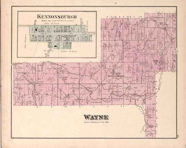
Photo: Wall, Mann & Hall; Worley & Bracher, via Library of Congress, public domain · Wikimedia Commons
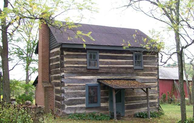
Photo: Bwsmith84, CC BY 3.0 · Wikimedia Commons
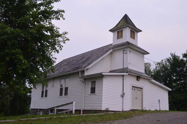
Photo: Nyttend, public domain · Wikimedia Commons
Local history sources: en.wikipedia.org · en.wikipedia.org · archive.org · archive.org · archive.org · archive.org · en.wikipedia.org · en.wikipedia.org · commons.wikimedia.org · commons.wikimedia.org · commons.wikimedia.org
Historic places
1 place in Wayne Township, Noble County on the National Register of Historic Places. Press a pin or a name for its whole record.
-
Williams, Abner, Log HouseBuilding · Lashley · listed 1979
- Address
- NE of Lashley
- Where
- Lashley, Noble County · ZIP 43773
- What it is
- Building
- Listed on the National Register
- 1979
- NRIS reference number
- 79001923
- Coordinates
- 39.94629, -81.36037
National Register file (NPS) ↗ Search Wikipedia ↗ Street map and directions ↗ On the Cracked Buckeye map
Source: National Park Service, National Register of Historic Places point file. The listing year is shown where NPS's certification date agrees with the listing's reference number. Listing recognizes significance; it does not restrict a private owner.
Water
Mostly private wells The water here
- Quaker City82% of residentsBarnesville Reservoirs #1, #2 & Slope Creek Reservoir
- Byesville18% of residentslocal wells (mine-pool/groundwater under influence of surface water)
Hospitals, fire stations and more
Inside Wayne Township, Noble County's boundary: 1 poor-rated bridge, 10 shale and injection wells and 2 spill cases. Press a pin or a name for its whole record and its source.
Bridges rated poor (1)
-
Township Road 120 over Oppossum RunPoor · built 1900
- Condition
- Poor: a deck, superstructure, substructure or culvert rated 4 or below on the 0 to 9 scale
- What it is
- Culvert
- Built
- 1900
- Length
- 14 ft
- Owner
- County
- Vehicles a day
- 209
- Coordinates
- 39.89403, -81.44005
National Bridge Inventory (source) ↗ Street map and directions ↗
Source: FHWA National Bridge Inventory 2025. "Poor" means one major part rated 4 or below on the 0 to 9 scale; it calls for repair, not closing, unless the state posts or closes the bridge.
Shale and injection wells (10)
-
Andes-Quinn 1HuUtica shale well
- What it is
- Utica shale well
- Drilled sideways
- Yes
- Operator
- Inr Ohio Llc
- County
- Noble County
- API well number
- 34121246150000
- Coordinates
- 39.91282, -81.37116
ODNR oil and gas wells (source) ↗ Street map and directions ↗
The point is the surface well head (the pad); a horizontal well runs a mile or more underground from it.
-
Andes-Quinn 2HuUtica shale well
- What it is
- Utica shale well
- Drilled sideways
- Yes
- Operator
- Inr Ohio Llc
- County
- Noble County
- API well number
- 34121246160000
- Coordinates
- 39.91285, -81.37111
ODNR oil and gas wells (source) ↗ Street map and directions ↗
The point is the surface well head (the pad); a horizontal well runs a mile or more underground from it.
-
Andes-Quinn 3HuUtica shale well
- What it is
- Utica shale well
- Drilled sideways
- Yes
- Operator
- Inr Ohio Llc
- County
- Noble County
- API well number
- 34121246180000
- Coordinates
- 39.91287, -81.37107
ODNR oil and gas wells (source) ↗ Street map and directions ↗
The point is the surface well head (the pad); a horizontal well runs a mile or more underground from it.
-
Andes-Walleye 1HuUtica shale well
- What it is
- Utica shale well
- Drilled sideways
- Yes
- Operator
- Inr Ohio Llc
- County
- Noble County
- API well number
- 34121246170000
- Coordinates
- 39.91289, -81.37102
ODNR oil and gas wells (source) ↗ Street map and directions ↗
The point is the surface well head (the pad); a horizontal well runs a mile or more underground from it.
-
Andes-Walleye 2HuUtica shale well
- What it is
- Utica shale well
- Drilled sideways
- Yes
- Operator
- Inr Ohio Llc
- County
- Noble County
- API well number
- 34121246190000
- Coordinates
- 39.91292, -81.37098
ODNR oil and gas wells (source) ↗ Street map and directions ↗
The point is the surface well head (the pad); a horizontal well runs a mile or more underground from it.
-
Fuller 1HauUtica shale well
- What it is
- Utica shale well
- Drilled sideways
- Yes
- Operator
- Inr Ohio Llc
- County
- Noble County
- API well number
- 34121246070000
- Coordinates
- 39.91953, -81.35438
ODNR oil and gas wells (source) ↗ Street map and directions ↗
The point is the surface well head (the pad); a horizontal well runs a mile or more underground from it.
-
Fuller 2HuUtica shale well
- What it is
- Utica shale well
- Drilled sideways
- Yes
- Operator
- Inr Ohio Llc
- County
- Noble County
- API well number
- 34121245900000
- Coordinates
- 39.91961, -81.35439
ODNR oil and gas wells (source) ↗ Street map and directions ↗
The point is the surface well head (the pad); a horizontal well runs a mile or more underground from it.
-
Fuller-Turkey 1HuUtica shale well
- What it is
- Utica shale well
- Drilled sideways
- Yes
- Operator
- Inr Ohio Llc
- County
- Noble County
- API well number
- 34121245800000
- Coordinates
- 39.91965, -81.35439
ODNR oil and gas wells (source) ↗ Street map and directions ↗
The point is the surface well head (the pad); a horizontal well runs a mile or more underground from it.
-
Fuller-Turkey 2HuUtica shale well
- What it is
- Utica shale well
- Drilled sideways
- Yes
- Operator
- Inr Ohio Llc
- County
- Noble County
- API well number
- 34121245790000
- Coordinates
- 39.91969, -81.35440
ODNR oil and gas wells (source) ↗ Street map and directions ↗
The point is the surface well head (the pad); a horizontal well runs a mile or more underground from it.
-
Fuller-Turkey 3HuUtica shale well
- What it is
- Utica shale well
- Drilled sideways
- Yes
- Operator
- Inr Ohio Llc
- County
- Noble County
- API well number
- 34121245780000
- Coordinates
- 39.91973, -81.35441
ODNR oil and gas wells (source) ↗ Street map and directions ↗
The point is the surface well head (the pad); a horizontal well runs a mile or more underground from it.
Source: ODNR Division of Oil and Gas Resources well inventory (September 2026): drilled Utica, Marcellus and horizontal wells and Class II injection wells not plugged. Older vertical wells are on the full map.
Spills reported since 2021 (2)
-
Ethylene Glycol (C2H6O2)2023-02-13 · Wayne Twp
- Reported
- 2023-02-13
- What spilled
- Ethylene Glycol (C2H6O2)
- Largest amount reported
- 100 gallons
- Where
- Wayne Twp, Noble County
- Ohio EPA district office
- SEDO
- Ohio EPA case number
- 2302EPA0000223
Ohio EPA spill reports (source) ↗ Street map and directions ↗
-
Material Unknown2026-05-17 · Wayne Twp
- Reported
- 2026-05-17
- What spilled
- Material Unknown
- Where
- Wayne Twp, Noble County
- Ohio EPA district office
- SEDO
- Ohio EPA case number
- 2605EPA0000823
Ohio EPA spill reports (source) ↗ Street map and directions ↗
Source: Ohio EPA emergency response spill reports, 2021 to September 2026, one point per case where Ohio EPA placed it. A report is what the caller or responder recorded; amounts are often blank or estimated.
Its ZIP codes
Each ZIP code that touches Wayne Township, Noble County, with the share of its residents who live here and the same headline figures as the ZIP page.
| ZIP | Share | Water | Radon | Home value | Schools | Flood |
|---|---|---|---|---|---|---|
| 43780 Richland Township and Senecaville | 8% | Mostly private wells | 3.2 pCi/L average radon | Appraisal records without year built | Rolling Hills Local · 3.5 stars overall | 9.6% of residents in the 1% floodplain |
| 43773 Beaver Township and Quaker City | 8% | Mostly private wells | Too few radon tests | Appraisal records without year built | East Guernsey Local · 3.5 stars overall | 6.6% of residents in the 1% floodplain |
| 43778 Wills Township and Salesville | 4% | Mostly private wells | Too few radon tests | Appraisal records without year built | East Guernsey Local · 3.5 stars overall | 5.9% of residents in the 1% floodplain |
The county
Guernsey County: 14 ZIP codes, 32 cities, villages and townships, 39,085 people.
Nearby places
Quick answers
What county is Wayne Township, Ohio in?
Wayne Township, Noble County is a township in Guernsey County, Ohio, with 479 residents.
When was Wayne Township, Ohio founded?
Wayne Township, Noble County was settled about 1799 (Joseph Reeves's cabin, abandoned and later reoccupied); 1802 (John Vorhies, first permanent resident by his descendants' account); incorporated erected May 1, 1851 by the Noble County commissioners. Founders on record: Joseph Reeves; John Vorhies. Source
How did Wayne Township, Ohio get its name?
Wayne Township is one of twenty townships of that name in Ohio, the great majority named for Revolutionary War general Anthony Wayne, whose 1794 victory at Fallen Timbers opened much of the Ohio Country to settlement; no source specific to this township's 1851 naming was found, so the common Ohio pattern is given rather than asserted as fact for this place. Source
What ZIP code is Wayne Township, Ohio?
Wayne Township, Noble County is served by ZIP codes 43780, 43773 and 43778; 43780 holds the largest share of its residents.
Where does Wayne Township, Ohio get its water?
The main water source for Wayne Township, Noble County (Quaker City): Mostly private wells.
Cite this page
Cite this page as:
Cracked Buckeye, "Wayne Township, Noble County", https://crackedbuckeye.com/place/wayne-township-noble-county/, built 2026-10-31, accessed [date].
How to cite · Report a correction · Built 2026-10-31
