Local events in Wills Township, Guernsey County
Nothing is posted for Wills Township itself yet; here is what is on within 10 miles. All local events in Wills Township, Guernsey County
Know a calendar we should watch? Send the link
Checked October 20; the events page is refreshed daily.
How Wills Township, Guernsey County began
Wills Township was organized in 1810 in eastern Guernsey County and takes in the village of Old Washington, platted in 1805 by brothers George and Henry Beymer along Zane's Trace. The S Bridge, one of Ohio's four surviving S-shaped National Road bridges, built around 1828, also stands in the township. John and Moses Frame settled here from Pennsylvania in 1810, and in July 1863 Confederate cavalry from Morgan's Raid passed through Old Washington, leaving casualties buried in the local cemetery.
Settled 1810 (Frame families), platted Old Washington platted 1805, incorporated organized as a township, 1810; Old Washington incorporated 1829, by Old Washington: George and Henry Beymer.
Where the name comes from
The township is named for Wills Creek, which runs through eastern Guernsey County; the creek in turn was recorded by that name by the time of the earliest Euro-American surveys. Old Washington within the township was first called Beymerstown after its founders, then New Washington, and was renamed 'Old Washington' at the post office's request after confusion with Washington Court House.
Before the town
No Native American village or site specific to Wills Township was found in the sources checked, beyond the general county-wide record that Delaware, Shawnee, Wyandot, Miami, Ottawa and Mingo peoples hunted and traveled the Wills Creek watershed that gives the township its name.
Nations recorded here: Lenape (Delaware).
Timeline
- — George and Henry Beymer platted the settlement that became Old Washington, along Zane's Trace.
- — John Frame and his wife, and the Moses Frame family, moved from Pennsylvania and settled in Wills Township, then 'a lonely region.'
- — Matthew Doyle left Pennsylvania and moved to Wills Township.
- — The S Bridge was built on the National Road east of Old Washington, one of four S-shaped bridges surviving from the road's construction in Ohio.
- — Old Washington was incorporated (as 'Washington'), soon after the National Road reached it.
- — In July, Confederate cavalry from Morgan's Raid passed through Old Washington; three Confederate soldiers killed in the fighting were buried in the local cemetery.
Stories
Morgan's Raiders in Old Washington
In July 1863, during Confederate general John Hunt Morgan's long cavalry raid across southern Ohio, a detachment of his raiders rode into Old Washington, then still called Washington. An 1863 Harper's Weekly engraving titled 'Morgan's Raiders Enter Washington, Ohio' captured the scene for a national audience already following the raid's progress through newspapers. Fighting in and around the village left casualties on the Confederate side; three of Morgan's men were buried in the town cemetery, a lasting trace of the raid's passage through what was, by then, a quiet National Road town past its boomtown years.
An S in the road
When engineers building the National Road through Wills Township reached a stream crossing a few miles east of Old Washington around 1828, they built the crossing as a shallow S-curve rather than square the road to the water, letting the bridge meet the creek at a more stable angle. The result is one of just four S-shaped bridges that survive from the National Road's construction era in Ohio, still standing east of Old Washington on the old road alignment north of US 40.
Photographs
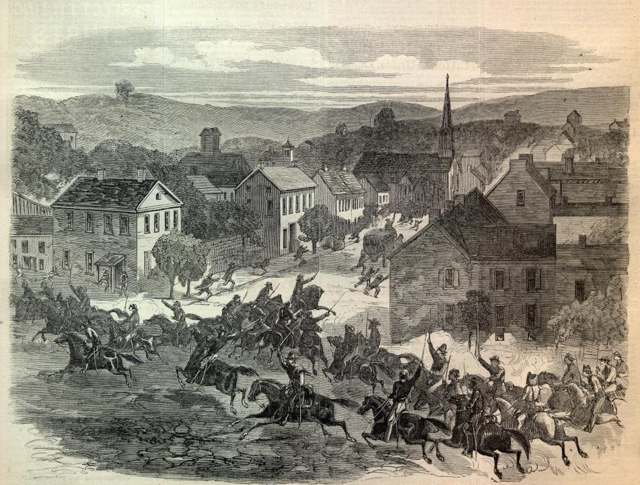
Photo: Harper's Weekly, public domain · Wikimedia Commons
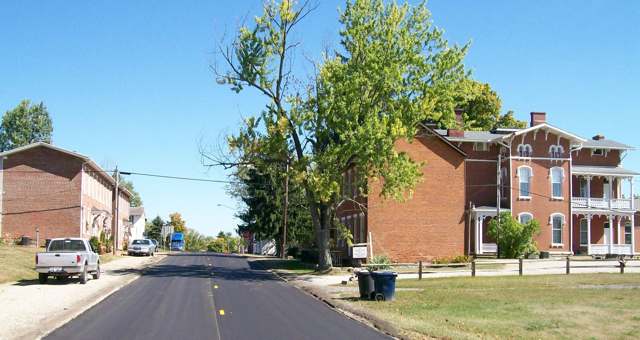
Photo: Bwsmith84, CC BY 3.0 · Wikimedia Commons
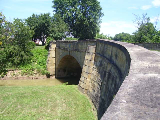
Photo: Stepshep, CC BY-SA 3.0 · Wikimedia Commons
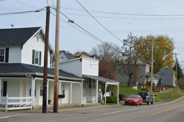
Photo: Nyttend, public domain · Wikimedia Commons
Local history sources: en.wikipedia.org · en.wikipedia.org · en.wikipedia.org · en.wikipedia.org · ohiogenealogyexpress.com · bettyshinn.com · commons.wikimedia.org · commons.wikimedia.org · commons.wikimedia.org · commons.wikimedia.org
Historic places
1 place in Wills Township, Guernsey County on the National Register of Historic Places, 1 of them National Historic Landmark. Press a pin or a name for its whole record.
-
S Bridge, National Road LandmarkStructure · Old Washington · listed 1966
- Address
- 4 mi. E of Old Washington on U.S. 40
- Where
- Old Washington, Guernsey County · ZIP 43778
- What it is
- Structure
- Listed on the National Register
- 1966
- National Historic Landmark
- Yes
- NRIS reference number
- 66000610
- Coordinates
- 40.04526, -81.37414
National Register file (NPS) ↗ Search Wikipedia ↗ Street map and directions ↗ On the Cracked Buckeye map
Source: National Park Service, National Register of Historic Places point file. The listing year is shown where NPS's certification date agrees with the listing's reference number. Listing recognizes significance; it does not restrict a private owner.
Water
No water-system data is linked to Wills Township, Guernsey County's ZIP codes yet.
Hospitals, fire stations and more
Inside Wills Township, Guernsey County's boundary: 4 public schools, 1 private school, 1 poor-rated bridge, 55 shale and injection wells and 5 spill cases. Press a pin or a name for its whole record and its source.
Public schools (4)
-
Buckeye Trail Elementary2.5 of 5 stars · Lore City
- Address
- 65553 Wintergreen Rd, Lore City, OH 43755
- School district
- East Guernsey Local School District
- Kind (NCES)
- Regular School
- Students, 2023-24
- 446
- Teachers (full-time equivalent)
- 29.11
- Report card, 2025-26
- 2.5 of 5 stars
- Performance index
- 72.6%
- Ohio building IRN
- 022095
- NCES school ID
- 390696804255
NCES school record ↗ Ohio School Report Card ↗ Street map and directions ↗
-
Buckeye Trail High School3.5 of 5 stars · Lore City
- Address
- 65555 Wintergreen Rd, Lore City, OH 43755
- School district
- East Guernsey Local School District
- Kind (NCES)
- Regular School
- Students, 2023-24
- 286
- Teachers (full-time equivalent)
- 20.71
- Report card, 2025-26
- 3.5 of 5 stars
- Performance index
- 75.1%
- Four-year graduation rate
- 98.8%
- Ohio building IRN
- 042564
- NCES school ID
- 390696804139
NCES school record ↗ Ohio School Report Card ↗ Street map and directions ↗
-
Buckeye Trail Middle School3.5 of 5 stars · Lore City
- Address
- 65553 Wintergreen Rd, Lore City, OH 43755
- School district
- East Guernsey Local School District
- Kind (NCES)
- Regular School
- Students, 2023-24
- 236
- Teachers (full-time equivalent)
- 14.67
- Report card, 2025-26
- 3.5 of 5 stars
- Performance index
- 68%
- Ohio building IRN
- 028522
- NCES school ID
- 390696804143
NCES school record ↗ Ohio School Report Card ↗ Street map and directions ↗
-
Preschool at Buckeye Trail High SchoolLore City
- Address
- 65555 Wintergreen Rd, Lore City, OH 43755
- Kind (NCES)
- Regular School
- Students, 2023-24
- 97
- NCES school ID
- 390696806064
Source: NCES EDGE public school locations 2024-25 and Common Core of Data 2023-24 (type, students, teachers); Ohio School Report Cards 2025-26 (Department of Education and Workforce), matched by name within the district.
Private schools (1)
-
Taflan Christian AcademyPrivate, religious, independent · Lore City
- Address
- 64068 County Home Rd, Lore City, OH 43755
- Kind
- religious, independent
- Students, 2023-24
- 5
- Teachers (full-time equivalent)
- 1
- Students per teacher
- 5
- Phone
- (740) 338-9272
- NCES private school ID
- A2302343
Source: NCES Private School Survey 2023-24.
Bridges rated poor (1)
-
TR 75 Reinhart Rd over Salt Fork (s Bridge)Poor · built 1828
- Condition
- Poor: a deck, superstructure, substructure or culvert rated 4 or below on the 0 to 9 scale
- What it is
- Bridge
- Built
- 1828
- Length
- 17 ft
- Owner
- County
- Vehicles a day
- 50
- Coordinates
- 40.04517, -81.37396
National Bridge Inventory (source) ↗ Street map and directions ↗
Source: FHWA National Bridge Inventory 2025. "Poor" means one major part rated 4 or below on the 0 to 9 scale; it calls for repair, not closing, unless the state posts or closes the bridge.
Shale and injection wells (55)
-
Callaway (Swiw #24) 1 InjectionInjection well (Class II)
- What it is
- Injection well (Class II)
- Operator
- Select Water Solutions, Llc
- County
- Guernsey County
- API well number
- 34059245270000
- Coordinates
- 40.02589, -81.44992
ODNR oil and gas wells (source) ↗ Street map and directions ↗
-
Cole 1HUtica shale well
- What it is
- Utica shale well
- Drilled sideways
- Yes
- Operator
- Inr Ohio Llc
- County
- Guernsey County
- API well number
- 34059243960000
- Coordinates
- 40.04359, -81.38114
ODNR oil and gas wells (source) ↗ Street map and directions ↗
The point is the surface well head (the pad); a horizontal well runs a mile or more underground from it.
-
Cole 2HUtica shale well
- What it is
- Utica shale well
- Drilled sideways
- Yes
- Operator
- Inr Ohio Llc
- County
- Guernsey County
- API well number
- 34059243950000
- Coordinates
- 40.04360, -81.38109
ODNR oil and gas wells (source) ↗ Street map and directions ↗
The point is the surface well head (the pad); a horizontal well runs a mile or more underground from it.
-
Cole 3HUtica shale well
- What it is
- Utica shale well
- Drilled sideways
- Yes
- Operator
- Inr Ohio Llc
- County
- Guernsey County
- API well number
- 34059243940000
- Coordinates
- 40.04361, -81.38104
ODNR oil and gas wells (source) ↗ Street map and directions ↗
The point is the surface well head (the pad); a horizontal well runs a mile or more underground from it.
-
Cole 4HUtica shale well
- What it is
- Utica shale well
- Drilled sideways
- Yes
- Operator
- Inr Ohio Llc
- County
- Guernsey County
- API well number
- 34059243900000
- Coordinates
- 40.04362, -81.38098
ODNR oil and gas wells (source) ↗ Street map and directions ↗
The point is the surface well head (the pad); a horizontal well runs a mile or more underground from it.
-
Commissioners 2HUtica shale well
- What it is
- Utica shale well
- Drilled sideways
- Yes
- Operator
- Inr Ohio Llc
- County
- Guernsey County
- API well number
- 34059243050000
- Coordinates
- 39.99818, -81.43684
ODNR oil and gas wells (source) ↗ Street map and directions ↗
The point is the surface well head (the pad); a horizontal well runs a mile or more underground from it.
-
Commissioners 3HUtica shale well
- What it is
- Utica shale well
- Drilled sideways
- Yes
- Operator
- Inr Ohio Llc
- County
- Guernsey County
- API well number
- 34059243040000
- Coordinates
- 39.99821, -81.43673
ODNR oil and gas wells (source) ↗ Street map and directions ↗
The point is the surface well head (the pad); a horizontal well runs a mile or more underground from it.
-
Cunningham 1HHorizontal shale well
- What it is
- Horizontal shale well
- Drilled sideways
- Yes
- Operator
- Inr Ohio Llc
- County
- Guernsey County
- API well number
- 34059246140000
- Coordinates
- 39.98233, -81.40654
ODNR oil and gas wells (source) ↗ Street map and directions ↗
The point is the surface well head (the pad); a horizontal well runs a mile or more underground from it.
-
Cunningham 2HHorizontal shale well
- What it is
- Horizontal shale well
- Drilled sideways
- Yes
- Operator
- Inr Ohio Llc
- County
- Guernsey County
- API well number
- 34059246150000
- Coordinates
- 39.98233, -81.40649
ODNR oil and gas wells (source) ↗ Street map and directions ↗
The point is the surface well head (the pad); a horizontal well runs a mile or more underground from it.
-
Cunningham 4HHorizontal shale well
- What it is
- Horizontal shale well
- Drilled sideways
- Yes
- Operator
- Inr Ohio Llc
- County
- Guernsey County
- API well number
- 34059246160000
- Coordinates
- 39.98233, -81.40644
ODNR oil and gas wells (source) ↗ Street map and directions ↗
The point is the surface well head (the pad); a horizontal well runs a mile or more underground from it.
-
Cunningham 5HHorizontal shale well
- What it is
- Horizontal shale well
- Drilled sideways
- Yes
- Operator
- Inr Ohio Llc
- County
- Guernsey County
- API well number
- 34059246170000
- Coordinates
- 39.98233, -81.40638
ODNR oil and gas wells (source) ↗ Street map and directions ↗
The point is the surface well head (the pad); a horizontal well runs a mile or more underground from it.
-
Cunningham Unit 3HUtica shale well
- What it is
- Utica shale well
- Drilled sideways
- Yes
- Operator
- Inr Ohio Llc
- County
- Guernsey County
- API well number
- 34059245770000
- Coordinates
- 39.98218, -81.40649
ODNR oil and gas wells (source) ↗ Street map and directions ↗
The point is the surface well head (the pad); a horizontal well runs a mile or more underground from it.
-
Detweiler 2HUtica shale well
- What it is
- Utica shale well
- Drilled sideways
- Yes
- Operator
- Inr Ohio Llc
- County
- Guernsey County
- API well number
- 34059242930100
- Coordinates
- 39.98885, -81.38638
ODNR oil and gas wells (source) ↗ Street map and directions ↗
The point is the surface well head (the pad); a horizontal well runs a mile or more underground from it.
-
Detweiler 3HUtica shale well
- What it is
- Utica shale well
- Drilled sideways
- Yes
- Operator
- Inr Ohio Llc
- County
- Guernsey County
- API well number
- 34059242920000
- Coordinates
- 39.98873, -81.38637
ODNR oil and gas wells (source) ↗ Street map and directions ↗
The point is the surface well head (the pad); a horizontal well runs a mile or more underground from it.
-
Detweiler 42-3HUtica shale well
- What it is
- Utica shale well
- Drilled sideways
- Yes
- Operator
- Inr Ohio Llc
- County
- Guernsey County
- API well number
- 34059242240000
- Coordinates
- 39.98890, -81.38647
ODNR oil and gas wells (source) ↗ Street map and directions ↗
The point is the surface well head (the pad); a horizontal well runs a mile or more underground from it.
-
Eggleston Wls Gr 2HUtica shale well
- What it is
- Utica shale well
- Drilled sideways
- Yes
- Operator
- Ascent Resources Utica Llc
- County
- Guernsey County
- API well number
- 34059244540000
- Coordinates
- 40.03434, -81.41613
ODNR oil and gas wells (source) ↗ Street map and directions ↗
The point is the surface well head (the pad); a horizontal well runs a mile or more underground from it.
-
Eggleston Wls Gr 4HUtica shale well
- What it is
- Utica shale well
- Drilled sideways
- Yes
- Operator
- Ascent Resources Utica Llc
- County
- Guernsey County
- API well number
- 34059244530000
- Coordinates
- 40.03437, -81.41607
ODNR oil and gas wells (source) ↗ Street map and directions ↗
The point is the surface well head (the pad); a horizontal well runs a mile or more underground from it.
-
Fineran 2HUtica shale well
- What it is
- Utica shale well
- Drilled sideways
- Yes
- Operator
- Expand Operating Llc
- County
- Guernsey County
- API well number
- 34059244140000
- Coordinates
- 40.02859, -81.34642
ODNR oil and gas wells (source) ↗ Street map and directions ↗
The point is the surface well head (the pad); a horizontal well runs a mile or more underground from it.
-
Fineran A 1HUtica shale well
- What it is
- Utica shale well
- Drilled sideways
- Yes
- Operator
- Expand Operating Llc
- County
- Guernsey County
- API well number
- 34059244160000
- Coordinates
- 40.02854, -81.34644
ODNR oil and gas wells (source) ↗ Street map and directions ↗
The point is the surface well head (the pad); a horizontal well runs a mile or more underground from it.
-
Fineran A 3HUtica shale well
- What it is
- Utica shale well
- Drilled sideways
- Yes
- Operator
- Expand Operating Llc
- County
- Guernsey County
- API well number
- 34059244150000
- Coordinates
- 40.02865, -81.34640
ODNR oil and gas wells (source) ↗ Street map and directions ↗
The point is the surface well head (the pad); a horizontal well runs a mile or more underground from it.
-
Fineran B 5HUtica shale well
- What it is
- Utica shale well
- Drilled sideways
- Yes
- Operator
- Expand Operating Llc
- County
- Guernsey County
- API well number
- 34059244170000
- Coordinates
- 40.02870, -81.34638
ODNR oil and gas wells (source) ↗ Street map and directions ↗
The point is the surface well head (the pad); a horizontal well runs a mile or more underground from it.
-
Fineran B 7HUtica shale well
- What it is
- Utica shale well
- Drilled sideways
- Yes
- Operator
- Expand Operating Llc
- County
- Guernsey County
- API well number
- 34059244180000
- Coordinates
- 40.02875, -81.34636
ODNR oil and gas wells (source) ↗ Street map and directions ↗
The point is the surface well head (the pad); a horizontal well runs a mile or more underground from it.
-
Gray Cw 5HuUtica shale well
- What it is
- Utica shale well
- Drilled sideways
- Yes
- Operator
- Inr Ohio Llc
- County
- Guernsey County
- API well number
- 34059247140000
- Coordinates
- 40.04689, -81.40007
ODNR oil and gas wells (source) ↗ Street map and directions ↗
The point is the surface well head (the pad); a horizontal well runs a mile or more underground from it.
-
Gray Cw 7HuUtica shale well
- What it is
- Utica shale well
- Drilled sideways
- Yes
- Operator
- Inr Ohio Llc
- County
- Guernsey County
- API well number
- 34059247150000
- Coordinates
- 40.04685, -81.40007
ODNR oil and gas wells (source) ↗ Street map and directions ↗
The point is the surface well head (the pad); a horizontal well runs a mile or more underground from it.
-
Gray W 1HuUtica shale well
- What it is
- Utica shale well
- Drilled sideways
- Yes
- Operator
- Inr Ohio Llc
- County
- Guernsey County
- API well number
- 34059247120000
- Coordinates
- 40.04697, -81.40006
ODNR oil and gas wells (source) ↗ Street map and directions ↗
The point is the surface well head (the pad); a horizontal well runs a mile or more underground from it.
-
Gray W 3HuUtica shale well
- What it is
- Utica shale well
- Drilled sideways
- Yes
- Operator
- Inr Ohio Llc
- County
- Guernsey County
- API well number
- 34059247130000
- Coordinates
- 40.04693, -81.40007
ODNR oil and gas wells (source) ↗ Street map and directions ↗
The point is the surface well head (the pad); a horizontal well runs a mile or more underground from it.
-
Jennings E Wls Gr 6HHorizontal shale well
- What it is
- Horizontal shale well
- Drilled sideways
- Yes
- Operator
- Ascent Resources Utica Llc
- County
- Guernsey County
- API well number
- 34059245920000
- Coordinates
- 40.01137, -81.45509
ODNR oil and gas wells (source) ↗ Street map and directions ↗
The point is the surface well head (the pad); a horizontal well runs a mile or more underground from it.
-
Jennings E Wls Gr 8HHorizontal shale well
- What it is
- Horizontal shale well
- Drilled sideways
- Yes
- Operator
- Ascent Resources Utica Llc
- County
- Guernsey County
- API well number
- 34059245930000
- Coordinates
- 40.01137, -81.45502
ODNR oil and gas wells (source) ↗ Street map and directions ↗
The point is the surface well head (the pad); a horizontal well runs a mile or more underground from it.
-
Jennings W Wls Gr 2HHorizontal shale well
- What it is
- Horizontal shale well
- Drilled sideways
- Yes
- Operator
- Ascent Resources Utica Llc
- County
- Guernsey County
- API well number
- 34059245900000
- Coordinates
- 40.01137, -81.45524
ODNR oil and gas wells (source) ↗ Street map and directions ↗
The point is the surface well head (the pad); a horizontal well runs a mile or more underground from it.
-
Jennings W Wls Gr 4HHorizontal shale well
- What it is
- Horizontal shale well
- Drilled sideways
- Yes
- Operator
- Ascent Resources Utica Llc
- County
- Guernsey County
- API well number
- 34059245910000
- Coordinates
- 40.01137, -81.45516
ODNR oil and gas wells (source) ↗ Street map and directions ↗
The point is the surface well head (the pad); a horizontal well runs a mile or more underground from it.
-
Johnson 1HUtica shale well
- What it is
- Utica shale well
- Drilled sideways
- Yes
- Operator
- Inr Ohio Llc
- County
- Guernsey County
- API well number
- 34059245620000
- Coordinates
- 40.01549, -81.39649
ODNR oil and gas wells (source) ↗ Street map and directions ↗
The point is the surface well head (the pad); a horizontal well runs a mile or more underground from it.
-
Johnson 2HHorizontal shale well
- What it is
- Horizontal shale well
- Drilled sideways
- Yes
- Operator
- Inr Ohio Llc
- County
- Guernsey County
- API well number
- 34059245980000
- Coordinates
- 40.01559, -81.39637
ODNR oil and gas wells (source) ↗ Street map and directions ↗
The point is the surface well head (the pad); a horizontal well runs a mile or more underground from it.
-
Johnson 3HHorizontal shale well
- What it is
- Horizontal shale well
- Drilled sideways
- Yes
- Operator
- Inr Ohio Llc
- County
- Guernsey County
- API well number
- 34059245960000
- Coordinates
- 40.01563, -81.39631
ODNR oil and gas wells (source) ↗ Street map and directions ↗
The point is the surface well head (the pad); a horizontal well runs a mile or more underground from it.
-
Johnson 42HUtica shale well
- What it is
- Utica shale well
- Drilled sideways
- Yes
- Operator
- Inr Ohio Llc
- County
- Guernsey County
- API well number
- 34059246240000
- Coordinates
- 40.01560, -81.39620
ODNR oil and gas wells (source) ↗ Street map and directions ↗
The point is the surface well head (the pad); a horizontal well runs a mile or more underground from it.
-
Johnson 5HUtica shale well
- What it is
- Utica shale well
- Drilled sideways
- Yes
- Operator
- Inr Ohio Llc
- County
- Guernsey County
- API well number
- 34059245760000
- Coordinates
- 40.01554, -81.39642
ODNR oil and gas wells (source) ↗ Street map and directions ↗
The point is the surface well head (the pad); a horizontal well runs a mile or more underground from it.
-
Johnson South 7HuUtica shale well
- What it is
- Utica shale well
- Drilled sideways
- Yes
- Operator
- Inr Ohio Llc
- County
- Guernsey County
- API well number
- 34059246590000
- Coordinates
- 40.01572, -81.39620
ODNR oil and gas wells (source) ↗ Street map and directions ↗
The point is the surface well head (the pad); a horizontal well runs a mile or more underground from it.
-
Law 4HUtica shale well
- What it is
- Utica shale well
- Drilled sideways
- Yes
- Operator
- Expand Operating Llc
- County
- Guernsey County
- API well number
- 34059244230000
- Coordinates
- 39.99092, -81.35197
ODNR oil and gas wells (source) ↗ Street map and directions ↗
The point is the surface well head (the pad); a horizontal well runs a mile or more underground from it.
-
Law B 2HUtica shale well
- What it is
- Utica shale well
- Drilled sideways
- Yes
- Operator
- Expand Operating Llc
- County
- Guernsey County
- API well number
- 34059245170000
- Coordinates
- 39.99453, -81.34697
ODNR oil and gas wells (source) ↗ Street map and directions ↗
The point is the surface well head (the pad); a horizontal well runs a mile or more underground from it.
-
Neff 1HHorizontal shale well
- What it is
- Horizontal shale well
- Drilled sideways
- Yes
- Operator
- Inr Ohio Llc
- County
- Guernsey County
- API well number
- 34059245880000
- Coordinates
- 40.00568, -81.38899
ODNR oil and gas wells (source) ↗ Street map and directions ↗
The point is the surface well head (the pad); a horizontal well runs a mile or more underground from it.
-
Neff 2HHorizontal shale well
- What it is
- Horizontal shale well
- Drilled sideways
- Yes
- Operator
- Inr Ohio Llc
- County
- Guernsey County
- API well number
- 34059245890000
- Coordinates
- 40.00563, -81.38904
ODNR oil and gas wells (source) ↗ Street map and directions ↗
The point is the surface well head (the pad); a horizontal well runs a mile or more underground from it.
-
Neff 3HUtica shale well
- What it is
- Utica shale well
- Drilled sideways
- Yes
- Operator
- Inr Ohio Llc
- County
- Guernsey County
- API well number
- 34059244810000
- Coordinates
- 40.00572, -81.38909
ODNR oil and gas wells (source) ↗ Street map and directions ↗
The point is the surface well head (the pad); a horizontal well runs a mile or more underground from it.
-
Onega Commissioners 14-25HUtica shale well
- What it is
- Utica shale well
- Drilled sideways
- Yes
- Operator
- Inr Ohio Llc
- County
- Guernsey County
- API well number
- 34059242110100
- Coordinates
- 39.99826, -81.43682
ODNR oil and gas wells (source) ↗ Street map and directions ↗
The point is the surface well head (the pad); a horizontal well runs a mile or more underground from it.
-
Outlaw A 1HUtica shale well
- What it is
- Utica shale well
- Drilled sideways
- Yes
- Operator
- Expand Operating Llc
- County
- Guernsey County
- API well number
- 34059244250000
- Coordinates
- 39.99097, -81.35202
ODNR oil and gas wells (source) ↗ Street map and directions ↗
The point is the surface well head (the pad); a horizontal well runs a mile or more underground from it.
-
Outlaw B 3HUtica shale well
- What it is
- Utica shale well
- Drilled sideways
- Yes
- Operator
- Expand Operating Llc
- County
- Guernsey County
- API well number
- 34059244240000
- Coordinates
- 39.99088, -81.35192
ODNR oil and gas wells (source) ↗ Street map and directions ↗
The point is the surface well head (the pad); a horizontal well runs a mile or more underground from it.
-
Outlaw B 5HUtica shale well
- What it is
- Utica shale well
- Drilled sideways
- Yes
- Operator
- Expand Operating Llc
- County
- Guernsey County
- API well number
- 34059245160000
- Coordinates
- 39.99453, -81.34705
ODNR oil and gas wells (source) ↗ Street map and directions ↗
The point is the surface well head (the pad); a horizontal well runs a mile or more underground from it.
-
Outlaw C 7HUtica shale well
- What it is
- Utica shale well
- Drilled sideways
- Yes
- Operator
- Expand Operating Llc
- County
- Guernsey County
- API well number
- 34059245180000
- Coordinates
- 39.99453, -81.34689
ODNR oil and gas wells (source) ↗ Street map and directions ↗
The point is the surface well head (the pad); a horizontal well runs a mile or more underground from it.
-
Scott 1HUtica shale well
- What it is
- Utica shale well
- Drilled sideways
- Yes
- Operator
- Expand Operating Llc
- County
- Guernsey County
- API well number
- 34059244350000
- Coordinates
- 40.02046, -81.35288
ODNR oil and gas wells (source) ↗ Street map and directions ↗
The point is the surface well head (the pad); a horizontal well runs a mile or more underground from it.
-
Scott 5HUtica shale well
- What it is
- Utica shale well
- Drilled sideways
- Yes
- Operator
- Expand Operating Llc
- County
- Guernsey County
- API well number
- 34059244370000
- Coordinates
- 40.02057, -81.35291
ODNR oil and gas wells (source) ↗ Street map and directions ↗
The point is the surface well head (the pad); a horizontal well runs a mile or more underground from it.
-
Shields One (Swiw #17) 1 InjectionInjection well (Class II)
- What it is
- Injection well (Class II)
- Operator
- Select Water Solutions, Llc
- County
- Guernsey County
- API well number
- 34059244450000
- Coordinates
- 40.02743, -81.44971
ODNR oil and gas wells (source) ↗ Street map and directions ↗
-
Shipman Wls Gr 2HUtica shale well
- What it is
- Utica shale well
- Drilled sideways
- Yes
- Operator
- Ascent Resources Utica Llc
- County
- Guernsey County
- API well number
- 34059244670000
- Coordinates
- 40.03226, -81.43530
ODNR oil and gas wells (source) ↗ Street map and directions ↗
The point is the surface well head (the pad); a horizontal well runs a mile or more underground from it.
-
Shipman Wls Gr 4HUtica shale well
- What it is
- Utica shale well
- Drilled sideways
- Yes
- Operator
- Ascent Resources Utica Llc
- County
- Guernsey County
- API well number
- 34059244680000
- Coordinates
- 40.03221, -81.43528
ODNR oil and gas wells (source) ↗ Street map and directions ↗
The point is the surface well head (the pad); a horizontal well runs a mile or more underground from it.
-
Shipman Wls Gr 6HUtica shale well
- What it is
- Utica shale well
- Drilled sideways
- Yes
- Operator
- Ascent Resources Utica Llc
- County
- Guernsey County
- API well number
- 34059244690000
- Coordinates
- 40.03216, -81.43526
ODNR oil and gas wells (source) ↗ Street map and directions ↗
The point is the surface well head (the pad); a horizontal well runs a mile or more underground from it.
-
Shugert Daddy E Wls Gr 5HUtica shale well
- What it is
- Utica shale well
- Drilled sideways
- Yes
- Operator
- Ascent Resources Utica Llc
- County
- Guernsey County
- API well number
- 34059243140000
- Coordinates
- 40.00519, -81.41129
ODNR oil and gas wells (source) ↗ Street map and directions ↗
The point is the surface well head (the pad); a horizontal well runs a mile or more underground from it.
-
Shugert Daddy Wls Gr 1HUtica shale well
- What it is
- Utica shale well
- Drilled sideways
- Yes
- Operator
- Ascent Resources Utica Llc
- County
- Guernsey County
- API well number
- 34059243340000
- Coordinates
- 40.00511, -81.41139
ODNR oil and gas wells (source) ↗ Street map and directions ↗
The point is the surface well head (the pad); a horizontal well runs a mile or more underground from it.
-
Shugert Daddy Wls Gr 3HUtica shale well
- What it is
- Utica shale well
- Drilled sideways
- Yes
- Operator
- Ascent Resources Utica Llc
- County
- Guernsey County
- API well number
- 34059243350000
- Coordinates
- 40.00514, -81.41134
ODNR oil and gas wells (source) ↗ Street map and directions ↗
The point is the surface well head (the pad); a horizontal well runs a mile or more underground from it.
Source: ODNR Division of Oil and Gas Resources well inventory (September 2026): drilled Utica, Marcellus and horizontal wells and Class II injection wells not plugged. Older vertical wells are on the full map.
Spills reported since 2021 (5)
-
Brine Oil And Gas Related2023-04-22 · Wills Twp
- Reported
- 2023-04-22
- What spilled
- Brine Oil And Gas Related
- Where
- Wills Twp, Guernsey County
- Ohio EPA district office
- SEDO
- Ohio EPA case number
- 2304EPA0000647
Ohio EPA spill reports (source) ↗ Street map and directions ↗
-
Material Green2023-02-24 · Center Twp
- Reported
- 2023-02-24
- What spilled
- Material Green
- Where
- Center Twp, Guernsey County
- Ohio EPA district office
- SEDO
- Ohio EPA case number
- 2303EPA0000438
Ohio EPA spill reports (source) ↗ Street map and directions ↗
-
Nitric Acid (Hno3)2022-09-06 · Wills Twp
- Reported
- 2022-09-06
- What spilled
- Nitric Acid (Hno3); Lead (Pb); Corrosive Liquid (Nos)
- Where
- Wills Twp, Guernsey County
- Ohio EPA district office
- SEDO
- Ohio EPA case number
- 2209EPA0001357
Ohio EPA spill reports (source) ↗ Street map and directions ↗
-
Fuel Diesel / Diesel Fuel (Vehicle On Or Off Road)2021-09-20 · Wills Twp
- Reported
- 2021-09-20
- What spilled
- Fuel Diesel / Diesel Fuel (Vehicle On Or Off Road)
- Where
- Wills Twp, Guernsey County
- Ohio EPA district office
- SEDO
- Ohio EPA case number
- 2109EPA0001489
Ohio EPA spill reports (source) ↗ Street map and directions ↗
-
Oil Crude Reached water2021-03-23 · Wills Twp
- Reported
- 2021-03-23
- What spilled
- Oil Crude
- Reached a waterway
- 99 - Unnamed
- Where
- Wills Twp, Guernsey County
- Ohio EPA district office
- SEDO
- Ohio EPA case number
- 2103EPA0000385
Ohio EPA spill reports (source) ↗ Street map and directions ↗
Source: Ohio EPA emergency response spill reports, 2021 to September 2026, one point per case where Ohio EPA placed it. A report is what the caller or responder recorded; amounts are often blank or estimated.
Its ZIP codes
Each ZIP code that touches Wills Township, Guernsey County, with the share of its residents who live here and the same headline figures as the ZIP page.
| ZIP | Share | Water | Radon | Home value | Schools | Flood |
|---|---|---|---|---|---|---|
| 43778 Wills Township and Salesville | 46% | Mostly private wells | Too few radon tests | Appraisal records without year built | East Guernsey Local · 3.5 stars overall | 5.9% of residents in the 1% floodplain |
| 43755 Madison Township and Lore City | 28% | Mostly private wells | 16.4 pCi/L average radon | Appraisal records without year built | East Guernsey Local · 3.5 stars overall | 8.1% of residents in the 1% floodplain |
Local government
Who holds office in Wills Township, Guernsey County, how its elections and ballot issues came out, and the state auditor's record.
Money issues on the ballot since 2023: 2 of 2 passed.
Ballot issues
| Date | Issue | For | Against | Result |
|---|---|---|---|---|
| 2026-05-05 | Issue: Wills Township fire protection | 96 | 65 | Passed (59.63% for) |
| 2023-11-07 | Issue: Wills Township Fire | 252 | 154 | Passed (62.07% for) |
Elections for office
| Date | Office | Candidates and votes |
|---|---|---|
| 2025-11-04 | Trustee | Tim Gray 134, 52.96%; Curt Laughman 119, 47.04% |
| 2023-11-07 | Trustee | Douglas E. Bates 423, 100.0% |
| 2023-11-07 | Fiscal Officer | Miranda Miser 378, 100.0% |
Winners in bold. Results from the county board of elections' official canvass unless marked.
The county
Guernsey County: 14 ZIP codes, 32 cities, villages and townships, 39,085 people.
Nearby places
Quick answers
What county is Wills Township, Ohio in?
Wills Township, Guernsey County is a township in Guernsey County, Ohio, with 1,182 residents.
When was Wills Township, Ohio founded?
Wills Township, Guernsey County was settled 1810 (Frame families); laid out Old Washington platted 1805; incorporated organized as a township, 1810; Old Washington incorporated 1829. Founders on record: Old Washington: George and Henry Beymer. Source
How did Wills Township, Ohio get its name?
The township is named for Wills Creek, which runs through eastern Guernsey County; the creek in turn was recorded by that name by the time of the earliest Euro-American surveys. Source
What ZIP code is Wills Township, Ohio?
Wills Township, Guernsey County is served by ZIP codes 43778 and 43755; 43778 holds the largest share of its residents.
Where does Wills Township, Ohio get its water?
The main water source for Wills Township, Guernsey County: Mostly private wells.
Cite this page
Cite this page as:
Cracked Buckeye, "Wills Township, Guernsey County", https://crackedbuckeye.com/place/wills-township-guernsey-county/, built 2026-10-31, accessed [date].
How to cite · Report a correction · Built 2026-10-31
