Local events in Lyndhurst
Nothing is posted for Lyndhurst itself yet; here is what is on within 10 miles. All local events in Lyndhurst
Know a calendar we should watch? Send the link
Checked October 20; the events page is refreshed daily.
Notable people from Lyndhurst
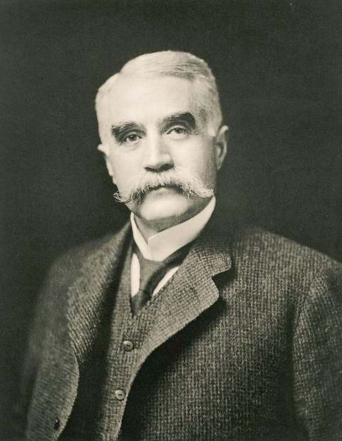
Ohioans tied to this place, each with a sourced profile. All notable Ohioans

How Lyndhurst began
Lyndhurst's land was part of Euclid Township, whose surveyor-employees named it in 1796 for the mathematician Euclid because their own training was chiefly mathematical; the township organized in 1809 and was divided into nine numbered sections in 1828, with the future Lyndhurst as District Four. Mayfield Road became the district's principal route by 1877, and the German-immigrant farming community, still known as Euclidville, incorporated as a village in 1917 (sources differ on the exact sequence), taking the name Lyndhurst in 1920 -- chosen through a high school contest as a salute to Lyndhurst, New Jersey. Water mains installed in 1922 helped the population grow from 288 in 1920 to 2,400 in 1940 and a peak of about 19,800 by 1970; TRW Inc. built its world headquarters there in 1983 on the former estate of Congresswoman Frances Payne Bolton. From 1957 to 2013 Lyndhurst was also home to Eggshelland, an elaborate annual lawn display of Easter egg mosaics that became the subject of a documentary before relocating to neighboring Chester Township by 2022.
Platted 1809 (Euclid Township organized); 1828 (divided into nine sections, Lyndhurst as District Four), incorporated 1917 (village, as Euclidville, per the Encyclopedia of Cleveland History) or 1920 (village, per Wikipedia); renamed Lyndhurst 1920; city 1921 (Wikipedia) or 1951 (Encyclopedia of Cleveland History).
Where the name comes from
The surveyors and laborers employed by the Connecticut Land Company, whose education had been chiefly mathematical, agreed in 1796 to name their assigned township for the Greek mathematician Euclid. The community occupying the future Lyndhurst was known as Euclidville within that township until a high school contest chose the name Lyndhurst in 1920, as a salute to Lyndhurst, New Jersey.
Before the town
Wikipedia's article on Lyndhurst states that the land was 'obtained via treaty with the Iroquois tribe in 1796 by the Connecticut Land Company,' and separately that Native Americans made up the majority of the area's population until after 1812; we could not confirm the specific 1796 Iroquois treaty referenced, since it does not match the 1785 Treaty of Fort McIntosh or 1795 Treaty of Greenville that secured the wider Western Reserve region from the Wyandot, Lenape, Ojibwe and Ottawa in other sources we checked, and may be a simplified or imprecise rendering of that broader treaty sequence, or refer to a separate right-of-way agreement the Connecticut Land Company's own surveyors made before their 1796 survey. No specific named Native village, trail or site within present Lyndhurst was found in the sources reviewed.
Timeline
- — Surveyors and laborers of the Connecticut Land Company, whose training was chiefly mathematical, agree to name their assigned township Euclid, for the Greek mathematician; Moses Cleaveland's survey party later applies the name to the wider area.
- — Euclid Township is formally organized.
- — Wikipedia's article on Lyndhurst states Native Americans no longer make up the majority of the local population after this date.
- — Euclid Township divides into nine numbered sections; the future Lyndhurst becomes District Four.
- — Mayfield Road becomes the district's principal traffic corridor.
- — Euclid Township's population reaches 3,573; residents support themselves through farming, fishing and allied trades, plus income from quarries, sawmills and shipbuilding.
- — The community, until then part of Euclid Township, incorporates as the village of Euclidville, according to the Encyclopedia of Cleveland History; Wikipedia instead places incorporation as Lyndhurst in 1920.
- — The Old Euclid District 4 Schoolhouse is built on Richmond Road; a high school contest chooses the name Lyndhurst, a salute to Lyndhurst, New Jersey, for the community until then known as Euclidville.
- — Installation of water mains, combined with increased automobile ownership, spurs Lyndhurst's growth from 288 residents in 1920 to 2,400 by 1940.
- — Lyndhurst residents reject a proposed school merger with South Euclid; a 1924 court decision rules that the broader interest of education should prevail, and the merger proceeds.
- — Lyndhurst incorporates as a city -- the two sources we reviewed disagree by three decades on the year.
- — A Lyndhurst resident begins Eggshelland, an annual lawn display of Easter egg mosaics, at their home.
- — Lyndhurst's population peaks at about 19,800 between World War II and 1970.
- — The Old Euclid District 4 Schoolhouse is listed on the National Register of Historic Places.
- — TRW, Inc. constructs its world headquarters in Lyndhurst on the former estate of Congressional members Chester Castle Bolton and Frances Payne Bolton.
- — Eggshelland's original 56-year run at its founding home ends, by which point it had been the subject of a documentary film.
- — New caretakers take over Eggshelland, relocating the display to various sites in and around Lyndhurst.
- — Eggshelland relocates to neighboring Chester Township; Legacy Village shopping mall, built after a 2000 zoning change on part of the former TRW estate, remains despite TRW's own relocation.
Stories
Fifty-six years of eggshell Easter art
Starting in 1957, a Lyndhurst resident began covering their lawn each spring with an elaborate mosaic display built from decorated eggshells -- a folk-art tradition unusual enough, and sustained long enough, that it eventually drew a documentary film crew to record it. Eggshelland ran at the same home for fifty-six years, through 2013, becoming a genuine local landmark that families would drive past every Easter season to see. When the original display finally ended, it did not simply disappear: a new set of caretakers took over in 2014, moving the display to different sites in and around Lyndhurst before it found a more permanent new home in neighboring Chester Township by 2022 -- a small, handmade tradition that managed to outlive both its original location and, eventually, the city it was named for.
A Congresswoman's estate becomes a headquarters, then a mall
Frances Payne Bolton, who represented a Cleveland-area district in the U.S. House for nearly three decades and was among the first women elected to Congress from Ohio, shared a family estate in Lyndhurst with her husband, Congressman Chester Castle Bolton. In 1983 the estate's land became the site of TRW, Inc.'s new world headquarters, planting a Fortune 500 company's global operations on what had been a Cleveland-area farming district only a few generations before, in the old District Four of Euclid Township. TRW itself eventually moved on, but the site did not go quiet: a 2000 zoning change opened part of the former estate to the Legacy Village shopping center, which has outlasted the company that first redeveloped the land.
Photographs
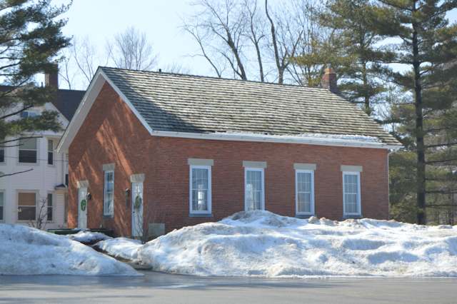
Photo: Nyttend (Wikimedia Commons), public domain · Wikimedia Commons
Local history sources: en.wikipedia.org · commons.wikimedia.org · archive.org · case.edu · case.edu
Historic places
2 places in Lyndhurst on the National Register of Historic Places. Press a pin or a name for its whole record.
-
Blossom, Elzabeth B. and Dudley S., Estate Service CompoundBuilding · Lyndhurst · listed 2004
- Address
- 24449 Cedar Rd.
- Where
- Lyndhurst, Cuyahoga County · ZIP 44124
- What it is
- Building
- Listed on the National Register
- 2004
- NRIS reference number
- 04000059
- Coordinates
- 41.50169, -81.50595
National Register file (NPS) ↗ Search Wikipedia ↗ Street map and directions ↗ On the Cracked Buckeye map
-
Old Euclid District 4 SchoolhouseBuilding · Lyndhurst · listed 1980
- Address
- Richmond Rd.
- Where
- Lyndhurst, Cuyahoga County · ZIP 44124
- What it is
- Building
- Listed on the National Register
- 1980
- NRIS reference number
- 80002982
- Coordinates
- 41.51824, -81.49791
National Register file (NPS) ↗ Search Wikipedia ↗ Street map and directions ↗ On the Cracked Buckeye map
Source: National Park Service, National Register of Historic Places point file. The listing year is shown where NPS's certification date agrees with the listing's reference number. Listing recognizes significance; it does not restrict a private owner.
Water
The Five Mile Crib, a small structure about 5 miles out in Lake Erie north of Cleveland's Edgewater Park The water here
- Cleveland Public Water System100% of residentsLake Erie
Hospitals, fire stations and more
Inside Lyndhurst's boundary: 2 nursing homes, 1 fire or EMS station, 2 public schools, 2 private schools, 1 police station, 2 public charging sites, 1 Toxics Release Inventory facility and 1 spill case. Press a pin or a name for its whole record and its source.
Nursing homes (2)
-
Avenue at Lyndhurst Special focus2 of 5 stars · Lyndhurst
- Address
- 5442 Rae Road, Lyndhurst, OH 44124
- Certified beds
- 102
- Residents on an average day
- 84
- Medicare overall rating
- 2 of 5 stars
- Health inspections
- 1 of 5 stars
- Staffing
- 2 of 5 stars
- Quality measures
- 5 of 5 stars
- Penalties since 2023
- none
- Special focus facility
- SFF Candidate
- Ownership
- For profit - Limited Liability company
- Chain
- PROGRESSIVE QUALITY CARE
- Takes
- Medicare and Medicaid
- Phone
- (440) 684-8448
- Medicare ID
- 366488
Medicare Care Compare ↗ CMS nursing home data (source) ↗ Street map and directions ↗
-
Heritage Healthcare of Lyndhurst1 of 5 stars · Lyndhurst
- Address
- 1575 Brainard Rd, Lyndhurst, OH 44124
- Certified beds
- 119
- Residents on an average day
- 92
- Medicare overall rating
- 1 of 5 stars
- Health inspections
- 1 of 5 stars
- Staffing
- 1 of 5 stars
- Quality measures
- 4 of 5 stars
- Penalties since 2023
- 2 fines totalling $149,620, 1 payment denial (latest 2025-04-07)
- Ownership
- For profit - Corporation
- Chain
- EMBASSY HEALTHCARE
- Takes
- Medicare and Medicaid
- Phone
- (440) 460-1000
- Medicare ID
- 366114
Medicare Care Compare ↗ CMS nursing home data (source) ↗ Street map and directions ↗
Source: CMS Care Compare nursing home provider and penalties files; Medicare star ratings run 1 to 5.
Fire and EMS stations (1)
-
Lyndhurst Fire DepartmentLyndhurst
- Address
- 5301 Mayfield Road, Lyndhurst, OH 44124
- Coordinates
- 41.52036, -81.48747
USGS National Map structures (source) ↗ Street map and directions ↗
Source: USGS National Map structures (most Ohio records last updated 2019 to 2022), checked against the Columbus and Cleveland station lists. The department that answers a call is set by jurisdiction and mutual aid, not by distance.
Public schools (2)
-
Brush High School3.5 of 5 stars · Lyndhurst
- Address
- 4875 Glenlyn Rd, Lyndhurst, OH 44124
- School district
- South Euclid-Lyndhurst City School District
- Kind (NCES)
- Regular School
- Students, 2023-24
- 1,008
- Teachers (full-time equivalent)
- 50.6
- Report card, 2025-26
- 3.5 of 5 stars
- Performance index
- 69.4%
- Four-year graduation rate
- 94.4%
- Ohio building IRN
- 003996
- NCES school ID
- 390447901645
NCES school record ↗ Ohio School Report Card ↗ Street map and directions ↗
-
Sunview Elementary School4 of 5 stars · Lyndhurst
- Address
- 5520 Meadow Wood Blvd, Lyndhurst, OH 44124
- School district
- South Euclid-Lyndhurst City School District
- Kind (NCES)
- Regular School
- Students, 2023-24
- 337
- Teachers (full-time equivalent)
- 22.35
- Report card, 2025-26
- 4 of 5 stars
- Performance index
- 82.4%
- Ohio building IRN
- 036525
- NCES school ID
- 390447901652
NCES school record ↗ Ohio School Report Card ↗ Street map and directions ↗
Source: NCES EDGE public school locations 2024-25 and Common Core of Data 2023-24 (type, students, teachers); Ohio School Report Cards 2025-26 (Department of Education and Workforce), matched by name within the district.
Private schools (2)
-
Beyond Camp/ Julie Billiart SchoolPrivate, Catholic · Lyndhurst
- Address
- 4982 Clubside Rd, Lyndhurst, OH 44124
- Kind
- Catholic
- Students, 2023-24
- 132
- Teachers (full-time equivalent)
- 29
- Students per teacher
- 4.55172
- Phone
- (216) 381-1191
- NCES private school ID
- 01057012
-
Corpus Christi AcademyPrivate, Catholic · Lyndhurst
- Address
- 5655 Mayfield Rd, Lyndhurst, OH 44124
- Kind
- Catholic
- Students, 2023-24
- 165
- Teachers (full-time equivalent)
- 14.5
- Students per teacher
- 11.3793
- Phone
- (440) 449-4244
- NCES private school ID
- A1702846
Source: NCES Private School Survey 2023-24.
Police stations (1)
-
Lyndhurst City Police DepartmentLyndhurst
- Address
- 5301 Mayfield Road, Lyndhurst, OH 44124
- Coordinates
- 41.52057, -81.48804
USGS National Map structures (source) ↗ Street map and directions ↗
Source: USGS National Map structures, police stations, corrected and completed by hand (September 2026). The department that answers a call is set by jurisdiction, not by distance.
Public EV charging (2)
-
Acacia Reservation2 Level 2 · Beachwood
- Address
- 26899 Cedar Road, Beachwood, OH 44144
- Ports
- 2 Level 2
- Plugs
- J1772
- Network
- FLO
- Hours
- 24 hours daily
- Phone
- 888-356-8911
Station Locator (NREL) ↗ Alternative Fuels Data Center (source) ↗ Street map and directions ↗
-
Legacy Village - Station 12 Level 2 · Lyndhurst
- Address
- 24665 Cedar Rd, Lyndhurst, OH 44124
- Ports
- 2 Level 2
- Plugs
- J1772
- Network
- ChargePoint Network
- Hours
- 24 hours daily
- Phone
- 216-382-3871
Station Locator (NREL) ↗ Alternative Fuels Data Center (source) ↗ Street map and directions ↗
Source: NREL Alternative Fuels Data Center station list (May 2026), public and open stations, the posts at one address counted as one site.
Facilities reporting toxic releases (1)
-
Ettkin Scrap Iron and MetalToxics Release Inventory · Lyndhurst
- Address
- 5560 Lansbury Ln, Lyndhurst, OH 44124
- County
- Cuyahoga County
- Status
- Reports to the Toxics Release Inventory
- EPA program ID
- TRI_OFFSITE_736
- EPA registry ID
- 110070690405
EPA facility record ↗ EPA Facility Registry Service (source) ↗ Street map and directions ↗
Source: EPA Facility Registry Service, Toxics Release Inventory reporters. Reporting a release is required of large users of listed chemicals; it is not by itself a violation.
Spills reported since 2021 (1)
-
Other / All Other / Trade Name / Mixture / Solution Etc2021-10-01 · Lyndhurst
- Reported
- 2021-10-01
- What spilled
- Other / All Other / Trade Name / Mixture / Solution Etc
- Largest amount reported
- 5 gallons
- Where
- Lyndhurst, Cuyahoga County
- Ohio EPA district office
- NEDO
- Ohio EPA case number
- 2110EPA0001557
Ohio EPA spill reports (source) ↗ Street map and directions ↗
Source: Ohio EPA emergency response spill reports, 2021 to September 2026, one point per case where Ohio EPA placed it. A report is what the caller or responder recorded; amounts are often blank or estimated.
Its ZIP codes
Each ZIP code that touches Lyndhurst, with the share of its residents who live here and the same headline figures as the ZIP page.
| ZIP | Share | Water | Radon | Home value | Schools | Flood |
|---|---|---|---|---|---|---|
| 44124 Mayfield Heights and Cleveland | 35% | The Five Mile Crib, a small structure about 5 miles out in Lake Erie north of Cleveland's Edgewater Park | 2.0 pCi/L average radon | Median year built 1956 | Mayfield City · 5 stars overall | 0.6% of residents in the 1% floodplain |
Local government
Who holds office in Lyndhurst, how its elections and ballot issues came out, and the state auditor's record.
Auditor of State record
- No fiscal caution, watch or emergency on the Auditor of State's lists.
- Financial Health Indicators (the Auditor of State's 17 measures; critical / cautionary / positive): 2020 1 / 2 / 14; 2021 0 / 2 / 15; 2022 0 / 1 / 16; 2023 0 / 3 / 14; 2024 0 / 2 / 15; 2025 0 / 2 / 14.
- Financial Audit, 2024, released 2025-12-02
- Financial Audit, 2023, released 2024-11-07
The county
Cuyahoga County: 52 ZIP codes, 59 cities, villages and townships, 1,270,867 people.
Nearby places
Rain and snow
How much has actually fallen on Lyndhurst, day by day, from 1871 to now. Daily totals, not averages.
- rain, last 30 days
- 1.90 in
- 2026-10-01 to 2026-10-30
- rain so far in 2026
- 34.0 in
- 1.9 in below normal for the date
- snow so far in 2026
- 44.2 in
- a normal year brings 66.5 in
- a normal year
- 43.4 in
- average of 27 years, 1991-2020
| Month | Rain (in) | Snow (in) | Days counted |
|---|---|---|---|
| October 2026 | 1.90 | — | 30 |
| September 2026 | 3.28 | — | 30 |
| August 2026 | 7.36 | — | 31 |
| July 2026 | 2.29 | — | 31 |
| June 2026 | 2.75 | — | 30 |
| May 2026 | 3.91 | — | 31 |
| April 2026 | 5.99 | 0.0 | 30 |
| March 2026 | 3.53 | 2.0 | 31 |
| February 2026 | 0.62 | 8.8 | 28 |
| January 2026 | 2.35 | 33.4 | 31 |
| December 2025 | 3.02 | 17.2 | 31 |
| November 2025 | 2.31 | 10.9 | 30 |
| Wettest year | 2011 — 69.0 in |
|---|---|
| Driest year | 1963 — 20.9 in |
| Snowiest year | 1996 — 121.3 in |
| Wettest day on record | 3 February 1883 — 3.62 in |
| Heaviest snowfall in a day | 25 December 2020 — 15.49 in |
| Deepest snow on the ground | 14 November 1996 — 32.99 in |
Estimated, not measured. No rain gauge has ever stood inside Lyndhurst, so every figure here is worked out from the gauges around it - the nearest ones weighted most. Treat them as close estimates rather than readings.
52,728 days of records, 1871-01-01 to 2026-10-30. Source: NOAA NCEI GHCN-Daily, 3,240 gauges in and around Ohio. A day is "gauged" when a gauge standing inside the boundary reported it, and the value is the mean of those gauges. Otherwise it is interpolated by inverse distance from every gauge reporting within 50 miles. Nothing is carried forward, back-filled or smoothed. Against NOAA nClimDiv county monthly precipitation over 136,848 complete county-months (checked 2026-11-01): correlation 0.9515, median absolute difference 0.217 in a month. Built 2026-11-01 from the Cracked Buckeye precipitation archive. Snow is the softer number — snowfall is measured by hand with a ruler, no agency publishes a gridded county snowfall series, and blowing snow defeats every observer.
Environmental permits and filings
What Ohio EPA has on file for Lyndhurst: permits, inspections, violations, cleanups and the state loans behind sewer and water work. Every line links to the agency's own document.
- facilities and sites on file
- 9
- those placed on the map inside Lyndhurst
| Program | Facilities and sites |
|---|---|
| Hazardous waste | 4 |
| Air pollution | 2 |
| Wastewater and stormwater discharge | 2 |
| State sewer loans | 1 |
| Date | Facility or site | What |
|---|---|---|
| HAWKEN SCHOOL - TENNIS COURTS | Wastewater and stormwater discharge permit | |
| HAWKEN SCHOOL - TENNIS COURTS | Wastewater and stormwater discharge permit | |
| HAWKEN SCHOOL - TENNIS COURTS | Wastewater and stormwater discharge permit | |
| WEST BRANCH EUCLID CREEK - MAYFIELD CAMPUS PHASE 1 & 2 | Wastewater and stormwater discharge permit | |
| WEST BRANCH EUCLID CREEK - MAYFIELD CAMPUS PHASE 2 | Wastewater and stormwater discharge permit | |
| LYNDHURST CITY HALL | Hazardous waste report | |
| CLEVELAND CLINIC-LYNDHURST CAMPUS | Hazardous waste compliance letter | |
| LYNDHURST CITY HALL | Hazardous waste compliance letter | |
| CVS PHARMACY #4499 | Hazardous waste inspection | |
| TRW INC | Air pollution inspection | |
| NE OHIO REGIONAL S D EASTERLY STP | State sewer loans |
Source: Ohio EPA eDocument portal (edocpub.epa.ohio.gov), indexed 2026-10-14. Facilities are placed on the map from Ohio EPA's own map layers, EPA's Facility Registry, coordinates written in the filings, or a geocoded street address. A permit filed under a private person's name (most are household septic systems) is counted but never named, placed or linked; licenses for individual workers and open-burning notices are left out entirely.
Quick answers
What county is Lyndhurst, Ohio in?
Lyndhurst is a city in Cuyahoga County, Ohio, with 14,050 residents.
When was Lyndhurst, Ohio founded?
Lyndhurst was laid out 1809 (Euclid Township organized); 1828 (divided into nine sections, Lyndhurst as District Four); incorporated 1917 (village, as Euclidville, per the Encyclopedia of Cleveland History) or 1920 (village, per Wikipedia); renamed Lyndhurst 1920; city 1921 (Wikipedia) or 1951 (Encyclopedia of Cleveland History). Source
How did Lyndhurst, Ohio get its name?
The surveyors and laborers employed by the Connecticut Land Company, whose education had been chiefly mathematical, agreed in 1796 to name their assigned township for the Greek mathematician Euclid. Source
What ZIP code is Lyndhurst, Ohio?
Most of Lyndhurst is in ZIP code 44124.
Where does Lyndhurst, Ohio get its water?
The main water source for Lyndhurst (Cleveland Public Water System): The Five Mile Crib, a small structure about 5 miles out in Lake Erie north of Cleveland's Edgewater Park.
Cite this page
Cite this page as:
Cracked Buckeye, "Lyndhurst, Cuyahoga County", https://crackedbuckeye.com/place/lyndhurst/, built 2026-10-31, accessed [date].
How to cite · Report a correction · Built 2026-10-31