Local events in Hunting Valley
Nothing is posted for Hunting Valley itself yet; here is what is on within 10 miles. All local events in Hunting Valley
Know a calendar we should watch? Send the link
Checked October 20; the events page is refreshed daily.
How Hunting Valley began
Hunting Valley was the northeast quadrant of Orange Township, settled in 1815 and organized in 1820 as a farming and dairy community. Cleveland industrialists began buying up its farmland around 1900 for country estates: Jeptha Homer Wade II bought 455 acres on Fairmount Road for his Valley Ridge Farm, and in 1913 attorney Andrew Squire built a working farm and horticultural center he later left to Western Reserve University in 1934. The railway-building Van Sweringen brothers bought a large tract east of SOM Center Road in the 1920s for their own country home, Daisy Hill, building Roundwood Manor there in 1923 or 1924 as part of their broader vision for a 'Shaker Country Estates' region. The village incorporated in 1924, and after 1940 landscape architect Albert Davis Taylor subdivided the estate land into more than 60 private lots under zoning that set a five-acre minimum and excluded most commercial and industrial use, producing one of Ohio's wealthiest communities.
Settled 1815 (Orange Township, broadly), incorporated 1924, from the northeast quadrant of Orange Township.
Where the name comes from
No source we reviewed explains the specific origin of the name Hunting Valley.
Before the town
No source reviewed identifies a specific, named Native American village, mound, or treaty site within present Hunting Valley; the land was part of Orange Township, organized in 1820 on ground ceded to the United States by the 1795 Treaty of Greenville. Pepper Pike, Moreland Hills, and Orange were also split from Orange Township.
Nations recorded here: Lenape (Delaware), Wyandot.
Timeline
- — Settlement begins in Orange Township, which will include the future Hunting Valley.
- — Orange Township formally organizes as a farming and dairy community.
- — James A. Garfield, later the 20th US president, is born within Orange Township, at a site that becomes part of the separate village of Moreland Hills.
- — Cleveland industrialists begin buying township farmland for country estates, including Jeptha Homer Wade II's 455-acre Valley Ridge Farm on Fairmount Road.
- — Attorney Andrew Squire builds a working farm and horticultural and landscape gardening center on his estate.
- — The Van Sweringen brothers buy a large tract east of SOM Center Road for their own country home, Daisy Hill, as part of their broader 'Shaker Country Estates' development vision.
- — Roundwood Manor is built at Daisy Hill Farm for the Van Sweringen brothers.
- — Hunting Valley incorporates as a village, covering the northeast quadrant of the original Orange Township.
- — Photographer Clifton Norton documents Roundwood Manor at Daisy Hill Farm.
- — Andrew Squire's estate is bequeathed to Western Reserve University.
- — Landscape architect Albert Davis Taylor divides the accumulated estate land into more than 60 private lots, with zoning setting a five-acre minimum and banning most commercial and industrial use.
Stories
Three fortunes remake a dairy township
Within about two decades, Hunting Valley's farmland passed from ordinary dairy country into the hands of three of Cleveland's wealthiest men. Jeptha Homer Wade II, heir to a telegraph and banking fortune, assembled 455 acres into his Valley Ridge Farm on Fairmount Road; attorney Andrew Squire built a working farm and horticultural center in 1913 that he eventually gave outright to Western Reserve University; and in the 1920s the Van Sweringen brothers, having already built the planned suburb of Shaker Heights and the rail line to serve it, bought a large eastern tract for their own country retreat, Daisy Hill, and built Roundwood Manor there around 1923. When the estate era wound down after 1940, landscape architect Albert Davis Taylor did not subdivide this accumulated land into an ordinary suburb -- he cut it into more than sixty private lots under zoning that required at least five acres each and banned nearly all commerce and industry, locking in the low-density character that later made Hunting Valley one of Ohio's wealthiest communities by median income.
Photographs
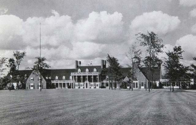
Photo: Clifton Norton, Western Reserve Historical Society, public domain · Wikimedia Commons
Local history sources: en.wikipedia.org · case.edu · commons.wikimedia.org · en.wikipedia.org
Water
The Five Mile Crib, a small structure about 5 miles out in Lake Erie north of Cleveland's Edgewater Park The water here
- Cleveland Public Water System60% of residentsLake Erie
- Chagrin Falls Village34% of residentsLake Erie
- Paw Paw Lake6% of residentsGroundwater wells (2 wells)
Hospitals, fire stations and more
Inside Hunting Valley's boundary: 1 poor-rated bridge, 1 police station and 1 spill case. Press a pin or a name for its whole record and its source.
Bridges rated poor (1)
-
Fairmount Blvd C19 over Chagrin RiverPoor · built 1910
- Condition
- Poor: a deck, superstructure, substructure or culvert rated 4 or below on the 0 to 9 scale
- What it is
- Bridge
- Built
- 1910
- Length
- 74 ft
- Owner
- County
- Vehicles a day
- 3,813
- Coordinates
- 41.48894, -81.39640
National Bridge Inventory (source) ↗ Street map and directions ↗
Source: FHWA National Bridge Inventory 2025. "Poor" means one major part rated 4 or below on the 0 to 9 scale; it calls for repair, not closing, unless the state posts or closes the bridge.
Police stations (1)
-
Hunting Valley Police DepartmentChagrin Falls
- Address
- 38251 Fairmount Boulevard, Chagrin Falls, OH 44022
- Coordinates
- 41.49129, -81.40689
USGS National Map structures (source) ↗ Street map and directions ↗
Source: USGS National Map structures, police stations, corrected and completed by hand (September 2026). The department that answers a call is set by jurisdiction, not by distance.
Spills reported since 2021 (1)
-
Material Gray Reached water2023-05-20 · Hunting Valley
- Reported
- 2023-05-20
- What spilled
- Material Gray
- Reached a waterway
- 18 - Chagrin River
- Where
- Hunting Valley, Cuyahoga County
- Ohio EPA district office
- NEDO
- Ohio EPA case number
- 2305EPA0000825
Ohio EPA spill reports (source) ↗ Street map and directions ↗
Source: Ohio EPA emergency response spill reports, 2021 to September 2026, one point per case where Ohio EPA placed it. A report is what the caller or responder recorded; amounts are often blank or estimated.
Its ZIP codes
Each ZIP code that touches Hunting Valley, with the share of its residents who live here and the same headline figures as the ZIP page.
| ZIP | Share | Water | Radon | Home value | Schools | Flood |
|---|---|---|---|---|---|---|
| 44022 Chagrin Falls | 4% | The Five Mile Crib, a small structure about 5 miles out in Lake Erie north of Cleveland's Edgewater Park | 2.6 pCi/L average radon | Median year built 1966 | Chagrin Falls Exempted Village · 5 stars overall | 0.8% of residents in the 1% floodplain |
| 44040 Gates Mills | 1% | The Five Mile Crib, a small structure about 5 miles out in Lake Erie north of Cleveland's Edgewater Park | 3.1 pCi/L average radon | Median year built 1963 | Mayfield City · 5 stars overall | 2.2% of residents in the 1% floodplain |
Local government
Who holds office in Hunting Valley, how its elections and ballot issues came out, and the state auditor's record.
Ballot issues
| Date | Issue | For | Against | Result |
|---|---|---|---|---|
| 2024-11-05 | Issue: Charter Amendment | 80 | 17 | Passed (82.47% for), unofficial |
Auditor of State record
- No fiscal caution, watch or emergency on the Auditor of State's lists.
- Financial Audit, 2024 to 2025, released 2026-07-14
- Financial Audit, 2022 to 2023, released 2024-09-03
The county
Cuyahoga County: 52 ZIP codes, 59 cities, villages and townships, 1,270,867 people.
Nearby places
Rain and snow
How much has actually fallen on Hunting Valley, day by day, from 1871 to now. Daily totals, not averages.
- rain, last 30 days
- 1.77 in
- 2026-09-29 to 2026-10-28
- rain so far in 2026
- 36.6 in
- 2.1 in below normal for the date
- snow so far in 2026
- 53.3 in
- a normal year brings 86.1 in
- a normal year
- 46.8 in
- average of 30 years, 1991-2020
| Month | Rain (in) | Snow (in) | Days counted |
|---|---|---|---|
| October 2026 | 1.77 | — | 28 |
| September 2026 | 3.00 | — | 30 |
| August 2026 | 9.16 | — | 31 |
| July 2026 | 2.58 | — | 31 |
| June 2026 | 2.33 | — | 30 |
| May 2026 | 4.23 | 0.1 | 31 |
| April 2026 | 7.12 | — | 30 |
| March 2026 | 3.19 | 2.2 | 31 |
| February 2026 | 0.79 | 10.6 | 28 |
| January 2026 | 2.49 | 40.4 | 31 |
| December 2025 | 2.98 | 17.2 | 31 |
| November 2025 | 2.30 | 12.3 | 30 |
| Wettest year | 2011 — 69.8 in |
|---|---|
| Driest year | 1963 — 24.4 in |
| Snowiest year | 1969 — 147.4 in |
| Wettest day on record | 28 July 2006 — 4.68 in |
| Heaviest snowfall in a day | 9 March 2008 — 15.98 in |
| Deepest snow on the ground | 14 November 1996 — 38.62 in |
Mostly estimated. Only 3% of these days come from a gauge standing inside Hunting Valley - the rest are worked out from the nearest gauges around it, so read them as close estimates rather than readings.
56,912 days of records, 1871-01-01 to 2026-10-28. Source: NOAA NCEI GHCN-Daily, 3,240 gauges in and around Ohio. A day is "gauged" when a gauge standing inside the boundary reported it, and the value is the mean of those gauges. Otherwise it is interpolated by inverse distance from every gauge reporting within 50 miles. Nothing is carried forward, back-filled or smoothed. Against NOAA nClimDiv county monthly precipitation over 136,848 complete county-months (checked 2026-10-31): correlation 0.9515, median absolute difference 0.217 in a month. Built 2026-10-31 from the Cracked Buckeye precipitation archive. Snow is the softer number — snowfall is measured by hand with a ruler, no agency publishes a gridded county snowfall series, and blowing snow defeats every observer.
Environmental permits and filings
What Ohio EPA has on file for Hunting Valley: permits, inspections, violations, cleanups and the state loans behind sewer and water work. Every line links to the agency's own document.
- facilities and sites on file
- 3
- those placed on the map inside Hunting Valley
| Program | Facilities and sites |
|---|---|
| Wastewater and stormwater discharge | 2 |
| Hazardous waste | 1 |
| Date | Facility or site | What |
|---|---|---|
| GEOBOB LLC | Wastewater and stormwater discharge permit |
Source: Ohio EPA eDocument portal (edocpub.epa.ohio.gov), indexed 2026-10-14. Facilities are placed on the map from Ohio EPA's own map layers, EPA's Facility Registry, coordinates written in the filings, or a geocoded street address. A permit filed under a private person's name (most are household septic systems) is counted but never named, placed or linked; licenses for individual workers and open-burning notices are left out entirely.
Quick answers
What county is Hunting Valley, Ohio in?
Hunting Valley is a village in Cuyahoga County, Ohio, with 763 residents.
When was Hunting Valley, Ohio founded?
Hunting Valley was settled 1815 (Orange Township, broadly); incorporated 1924, from the northeast quadrant of Orange Township. Source
What ZIP code is Hunting Valley, Ohio?
Most of Hunting Valley is in ZIP code 44022.
Where does Hunting Valley, Ohio get its water?
The main water source for Hunting Valley (Cleveland Public Water System): The Five Mile Crib, a small structure about 5 miles out in Lake Erie north of Cleveland's Edgewater Park.
Cite this page
Cite this page as:
Cracked Buckeye, "Hunting Valley, Cuyahoga County", https://crackedbuckeye.com/place/hunting-valley/, built 2026-10-31, accessed [date].
How to cite · Report a correction · Built 2026-10-31
