Local events in Lordstown
17 events in the next 90 days from 1 public calendar. All local events in Lordstown
Checked October 20; the events page is refreshed daily.
Lakes near Lordstown
The history under the water: the valley before, the dam, the stories. All Ohio lakes
Videos about Lordstown
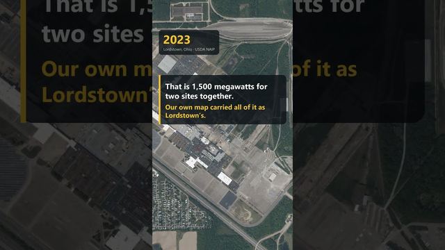
Short videos we made from the old maps and records. All videos
How Lordstown began
Lordstown takes its name from Samuel P. Lord, one of the five original Connecticut Land Company proprietors who divided the township that would later include Bazetta among their holdings and who laid out this township specifically; the village itself did not incorporate until 1975. Its modern identity was set decades earlier, when General Motors built an assembly plant here between 1964 and 1966 that became, after the Mahoning Valley's steel mills closed in the late 1970s and 1980s, the region's largest industrial employer -- and the site, in 1972, of a 22-day strike that cost GM $150 million and gave rise to the phrase 'Lordstown syndrome' for assembly-line worker alienation. GM ended production in 2019; the plant has since passed through Lordstown Motors and Foxconn before a 2025 sale toward data-center equipment manufacturing.
Incorporated 1975.
Where the name comes from
The village and township are named for Samuel P. Lord, one of the original Connecticut Land Company proprietors of the Western Reserve, who laid out this particular township.
Before the town
No Native village, camp or treaty event specific to Lordstown is recorded in the sources we reviewed. The site lies within the wider Mahoning-valley region the county's 1882 history describes as Delaware-occupied hunting ground used seasonally by Seneca and Mingo bands through the 1700s, but no source found names a specific site here.
Nations recorded here: Lenape (Delaware), Seneca, Mingo (Seneca-Cayuga).
Timeline
- — General Motors builds the Lordstown Assembly plant.
- — The first vehicle, a Chevrolet Impala, rolls off the Lordstown Assembly line.
- — A 22-day strike at the Lordstown plant costs General Motors $150 million and draws national attention to assembly-line working conditions, giving rise to the term 'Lordstown syndrome.'
- — Lordstown incorporates as a village.
- — The Almon G. McCorkle House at 1180 Salt Springs Road is listed on the National Register of Historic Places.
- — GM ends production at Lordstown Assembly; the final vehicle is a white Chevrolet Cruze LS.
- — The newly formed Lordstown Motors buys the shuttered plant from GM for about $20 million.
- — Lordstown Motors sells the plant to Foxconn for $230 million, aiming at electric-vehicle production.
- — Foxconn sells the property for $375 million to Crescent Dune LLC, reportedly SoftBank-affiliated, with plans to manufacture data-center equipment.
Stories
From Impala to Cruze to data centers
Lordstown was an obscure Western Reserve township named for a Connecticut land proprietor until General Motors, between 1964 and 1966, built an assembly plant on its farmland; the first Chevrolet Impala rolled off the line on April 28, 1966, nearly a decade before the village around the plant even incorporated in 1975. The relationship between plant and town was never entirely comfortable -- in 1972, workers staged a 22-day strike that cost GM $150 million and became a national symbol of assembly-line alienation under the name 'Lordstown syndrome,' a phrase that entered the broader vocabulary of American labor writing. The plant kept building cars -- Vega, Cavalier, Cobalt, Cruze -- for another four decades, surviving as the Mahoning Valley's largest industrial employer even after the region's steel mills shut down around it in the late 1970s and 1980s. GM's own production ended in March 2019, and the building has since changed hands twice more, first to the electric-truck startup Lordstown Motors and then, in 2022, to the Taiwanese manufacturer Foxconn -- before a 2025 sale pointed the site toward an entirely different industry, manufacturing equipment for data centers rather than cars.
Photographs
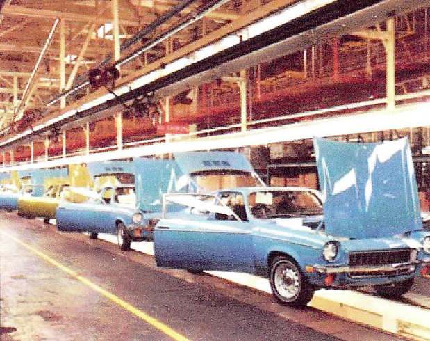
Photo: Chevrolet (factory photo), public domain · Wikimedia Commons
Local history sources: en.wikipedia.org · en.wikipedia.org · en.wikipedia.org · archive.org · commons.wikimedia.org
Historic places
1 place in Lordstown on the National Register of Historic Places. Press a pin or a name for its whole record.
-
McCorkle, Almon G., HouseBuilding · Lordstown · listed 1982
- Address
- 1180 Saltsprings Rd.
- Where
- Lordstown, Trumbull County · ZIP 44481
- What it is
- Building
- Listed on the National Register
- 1982
- NRIS reference number
- 82003659
- Coordinates
- 41.16629, -80.84437
National Register file (NPS) ↗ Search Wikipedia ↗ Street map and directions ↗ On the Cracked Buckeye map
Source: National Park Service, National Register of Historic Places point file. The listing year is shown where NPS's certification date agrees with the listing's reference number. Listing recognizes significance; it does not restrict a private owner.
Water
Mostly private wells The water here
- Lordstown Village63% of residentsMeander Creek Reservoir (via MVSD, blended w/ Mosquito Lake)
- Warren City15% of residentsMosquito Creek Lake (Mosquito Creek Reservoir)
- Trumbull Co. - Bazetta/champion13% of residentsMosquito Creek Lake (Mosquito Creek Reservoir)
- Trumbull Co. - Mineral Ridge5% of residentsMeander Creek Reservoir + Berlin Reservoir (Mahoning River basin)
- Pleasant Park Mobile Court3% of residentsGroundwater wells (1 wells)
- Youngstown City1% of residentsMeander Creek Reservoir + Berlin Reservoir (Mahoning River basin)
- Girard City1% of residentsMeander Creek Reservoir (via Niles/MVSD, blended)
- Belle Acres Mobile Home Park0% of residentsGroundwater wells (1 wells)
- Niles City0% of residentsMeander Creek Reservoir + Berlin Reservoir (Mahoning River basin)
Hospitals, fire stations and more
Inside Lordstown's boundary: 1 fire or EMS station, 2 power plants, 2 public schools, 1 poor-rated bridge, 1 library, 1 police station, 2 shale and injection wells, 5 Toxics Release Inventory facilities and 9 spill cases. Press a pin or a name for its whole record and its source.
Fire and EMS stations (1)
-
Lordstown Fire DepartmentLordstown
- Address
- 1595 Salt Springs Road, Lordstown, OH 44481
- Coordinates
- 41.16562, -80.85482
USGS National Map structures (source) ↗ Street map and directions ↗
Source: USGS National Map structures (most Ohio records last updated 2019 to 2022), checked against the Columbus and Cleveland station lists. The department that answers a call is set by jurisdiction and mutual aid, not by distance.
Power plants (2)
-
Clean Energy Future-Lordstown, LLC 100 MW or moreNatural gas · 858 MW
- Capacity
- 858 MW
- Main source
- Natural gas
- Technology
- Natural Gas Fired Combined Cycle
- Operator
- Clean Energy Future-Lordstown, LLC
- Sector
- IPP Non-CHP
- Where
- Lordstown, Trumbull County
- Generating units
- 3
- Built
- 2018
- EIA plant code
- 60376
EIA plant page ↗ EIA-860 (source) ↗ Street map and directions ↗
-
Foxconn OhioSolar · 2 MW
- Capacity
- 2 MW
- Main source
- Solar
- Technology
- Solar Photovoltaic
- Operator
- Foxconn
- Sector
- Industrial Non-CHP
- Where
- Warren, Trumbull County
Source: EIA-860 power plant inventory via HIFLD (February 2025), with plant codes, units and years from EIA-860 2025.
Public schools (2)
-
Lordstown Elementary School4 of 5 stars · Warren
- Address
- 1776 Salt Springs Rd, Warren, OH 44481
- School district
- Lordstown Local School District
- Kind (NCES)
- Regular School
- Students, 2023-24
- 225
- Teachers (full-time equivalent)
- 15.5
- Report card, 2025-26
- 4 of 5 stars
- Performance index
- 90.3%
- Ohio building IRN
- 021469
- NCES school ID
- 390502003874
NCES school record ↗ Ohio School Report Card ↗ Street map and directions ↗
-
Lordstown High School4 of 5 stars · Warren
- Address
- 1824 Salt Springs Rd, Warren, OH 44481
- School district
- Lordstown Local School District
- Kind (NCES)
- Regular School
- Students, 2023-24
- 178
- Teachers (full-time equivalent)
- 17.58
- Report card, 2025-26
- 4 of 5 stars
- Performance index
- 84.5%
- Four-year graduation rate
- 94.6%
- Ohio building IRN
- 021477
- NCES school ID
- 390502003875
NCES school record ↗ Ohio School Report Card ↗ Street map and directions ↗
Source: NCES EDGE public school locations 2024-25 and Common Core of Data 2023-24 (type, students, teachers); Ohio School Report Cards 2025-26 (Department of Education and Workforce), matched by name within the district.
Bridges rated poor (1)
-
Lords; Fka Ch-98-B over Mud CreekPoor · built 1983
- Condition
- Poor: a deck, superstructure, substructure or culvert rated 4 or below on the 0 to 9 scale
- What it is
- Culvert
- Built
- 1983
- Length
- 8 ft
- Owner
- County
- Vehicles a day
- 1,138
- Coordinates
- 41.14348, -80.82692
National Bridge Inventory (source) ↗ Street map and directions ↗
Source: FHWA National Bridge Inventory 2025. "Poor" means one major part rated 4 or below on the 0 to 9 scale; it calls for repair, not closing, unless the state posts or closes the bridge.
Public libraries (1)
-
Lordstown Branch LibraryBranch · Warren
- Address
- 1471 Salt Springs Road Sw, Warren, OH 44481
- What it is
- Branch
- Library system
- Warren-Trumbull County Public Library
- Open
- 1,352 hours a year, 52 weeks
- Building
- 3,800 sq ft
- System's visits, FY2024
- 434,200
- System's loans, FY2024
- 665,653
- People the system serves
- 142,591
- Phone
- (330) 824-2094
IMLS Public Libraries Survey (source) ↗ Street map and directions ↗
Source: IMLS Public Libraries Survey FY2024 (outlets and their systems). Any Ohio resident can get a free card at any Ohio public library.
Police stations (1)
-
Lordstown Police DepartmentLordstown
- Address
- 1583 Salt Springs Road, Lordstown, OH 44481
- Coordinates
- 41.16558, -80.85487
USGS National Map structures (source) ↗ Street map and directions ↗
Source: USGS National Map structures, police stations, corrected and completed by hand (September 2026). The department that answers a call is set by jurisdiction, not by distance.
Shale and injection wells (2)
-
Kibler 1HUtica shale well
- What it is
- Utica shale well
- Drilled sideways
- Yes
- Operator
- Pin Oak Energy Partners Llc
- County
- Trumbull County
- API well number
- 34155240640100
- Coordinates
- 41.17628, -80.81227
ODNR oil and gas wells (source) ↗ Street map and directions ↗
The point is the surface well head (the pad); a horizontal well runs a mile or more underground from it.
-
Kibler 2-3HUtica shale well
- What it is
- Utica shale well
- Drilled sideways
- Yes
- Operator
- Pin Oak Energy Partners Llc
- County
- Trumbull County
- API well number
- 34155240800000
- Coordinates
- 41.17629, -80.81212
ODNR oil and gas wells (source) ↗ Street map and directions ↗
The point is the surface well head (the pad); a horizontal well runs a mile or more underground from it.
Source: ODNR Division of Oil and Gas Resources well inventory (September 2026): drilled Utica, Marcellus and horizontal wells and Class II injection wells not plugged. Older vertical wells are on the full map.
Facilities reporting toxic releases (5)
-
General Motors Llc Lordstown ComplexToxics Release Inventory · Warren
- Address
- 2300 Hallock Young Road, Warren, OH 44481
- County
- Trumbull County
- Status
- Reports to the Toxics Release Inventory (active)
- EPA program ID
- 44482BCLRD2300H
- EPA registry ID
- 110000617226
EPA facility record ↗ EPA Facility Registry Service (source) ↗ Street map and directions ↗
-
Lordstown Motors CorporationToxics Release Inventory · Lordstown
- Address
- 2300 Hallock Young Rd, Lordstown, OH 44481
- County
- Trumbull County
- Status
- Reports to the Toxics Release Inventory
- EPA program ID
- 4448WLRDST23HAB
- EPA registry ID
- 110070732958
EPA facility record ↗ EPA Facility Registry Service (source) ↗ Street map and directions ↗
-
Matalco Usa, LlcToxics Release Inventory · Lordstown
- Address
- 5120 Tod Avenue Sw, Lordstown, OH 44481
- County
- Trumbull County
- Status
- Reports to the Toxics Release Inventory
- EPA program ID
- 4448WMTLCS512TD
- EPA registry ID
- 110069467552
EPA facility record ↗ EPA Facility Registry Service (source) ↗ Street map and directions ↗
-
Ppg Industries IncToxics Release Inventory · Warren
- Address
- 2823 Ellsworth Bailey Rd., Warren, OH 44481
- County
- Trumbull County
- Status
- Reports to the Toxics Release Inventory (active)
- EPA program ID
- 44481PPGND2823E
- EPA registry ID
- 110000389838
EPA facility record ↗ EPA Facility Registry Service (source) ↗ Street map and directions ↗
-
Ultium Cells LlcToxics Release Inventory · Warren
- Address
- 7400 Tod Ave Sw, Warren, OH 44481
- County
- Trumbull County
- Status
- Reports to the Toxics Release Inventory (***unchanged***)
- EPA program ID
- 4448WLTMCL74TDA
- EPA registry ID
- 110070945164
EPA facility record ↗ EPA Facility Registry Service (source) ↗ Street map and directions ↗
Source: EPA Facility Registry Service, Toxics Release Inventory reporters. Reporting a release is required of large users of listed chemicals; it is not by itself a violation.
Spills reported since 2021 (9)
-
Battery Acid (Dilute Sulfuric)2025-06-24 · Lordstown
- Reported
- 2025-06-24
- What spilled
- Battery Acid (Dilute Sulfuric)
- Where
- Lordstown, Trumbull County
- Ohio EPA district office
- NEDO
- Ohio EPA case number
- 2506EPA0001043
Ohio EPA spill reports (source) ↗ Street map and directions ↗
-
Sheen Rainbow / Hydrocarbon2025-01-30 · Lordstown
- Reported
- 2025-01-30
- What spilled
- Sheen Rainbow / Hydrocarbon
- Where
- Lordstown, Trumbull County
- Ohio EPA district office
- NEDO
- Ohio EPA case number
- 2501EPA0000125
Ohio EPA spill reports (source) ↗ Street map and directions ↗
-
Fuel Oil/ Home Heating / Heating Oil Reached water2024-04-02 · Lordstown
- Reported
- 2024-04-02
- What spilled
- Fuel Oil/ Home Heating / Heating Oil; Sheen Rainbow / Hydrocarbon
- Reached a waterway
- 99 - Unnamed
- Where
- Lordstown, Trumbull County
- Ohio EPA district office
- NEDO
- Ohio EPA case number
- 2404EPA0000514
Ohio EPA spill reports (source) ↗ Street map and directions ↗
-
Material Unknown2023-12-29 · Lordstown
- Reported
- 2023-12-29
- What spilled
- Material Unknown
- Where
- Lordstown, Trumbull County
- Ohio EPA district office
- NEDO
- Ohio EPA case number
- 2312EPA0002104
Ohio EPA spill reports (source) ↗ Street map and directions ↗
-
Oil Transformer Pcb2023-03-28 · Lordstown
- Reported
- 2023-03-28
- What spilled
- Oil Transformer Pcb
- Where
- Lordstown, Trumbull County
- Ohio EPA district office
- NEDO
- Ohio EPA case number
- 2303EPA0000465
Ohio EPA spill reports (source) ↗ Street map and directions ↗
-
Battery / Batteries Wet Cell2022-11-29 · Lordstown
- Reported
- 2022-11-29
- What spilled
- Battery / Batteries Wet Cell
- Where
- Lordstown, Trumbull County
- Ohio EPA district office
- NEDO
- Ohio EPA case number
- 2211EPA0001762
Ohio EPA spill reports (source) ↗ Street map and directions ↗
-
Fuel Diesel / Diesel Fuel (Vehicle On Or Off Road)2022-07-07 · Lordstown
- Reported
- 2022-07-07
- What spilled
- Fuel Diesel / Diesel Fuel (Vehicle On Or Off Road)
- Largest amount reported
- 60 gallons
- Where
- Lordstown, Trumbull County
- Ohio EPA district office
- NEDO
- Ohio EPA case number
- 2207EPA0001031
Ohio EPA spill reports (source) ↗ Street map and directions ↗
-
Ammonium Nitrate ((Nh4)(No3)) (H4N2O3)2021-04-30 · Lordstown
- Reported
- 2021-04-30
- What spilled
- Ammonium Nitrate ((Nh4)(No3)) (H4N2O3)
- Largest amount reported
- 100 gallons
- Where
- Lordstown, Trumbull County
- Ohio EPA district office
- NEDO
- Ohio EPA case number
- 2104EPA0000595
Ohio EPA spill reports (source) ↗ Street map and directions ↗
-
Leachate2026-07-06 · Lordstown
- Reported
- 2026-07-06
- What spilled
- Leachate
- Where
- Lordstown, Trumbull County
- Ohio EPA district office
- NEDO
- Ohio EPA case number
- 2607EPA0001220
Ohio EPA spill reports (source) ↗ Street map and directions ↗
Source: Ohio EPA emergency response spill reports, 2021 to September 2026, one point per case where Ohio EPA placed it. A report is what the caller or responder recorded; amounts are often blank or estimated.
Its ZIP codes
Each ZIP code that touches Lordstown, with the share of its residents who live here and the same headline figures as the ZIP page.
| ZIP | Share | Water | Radon | Home value | Schools | Flood |
|---|---|---|---|---|---|---|
| 44481 Lordstown and Warren | 32% | Mostly private wells | 3.5 pCi/L average radon | Median year built 1973 | Lordstown Local · 3.5 stars overall | 2.4% of residents in the 1% floodplain |
| 44440 Weathersfield Township and Mineral Ridge | 2% | Meander Creek Reservoir + Berlin Reservoir (Mahoning River basin) | 2.8 pCi/L average radon | Median year built 1971 | Weathersfield Local · 4.5 stars overall | 1.5% of residents in the 1% floodplain |
Local government
Who holds office in Lordstown, how its elections and ballot issues came out and the state auditor's record.
Who holds office
| Office | Name | Party | Term ends | Contact |
|---|---|---|---|---|
| Mayor | JACKIE WOODWARD | Democratic | 12/31/2027 | 3020 LYNTZ RD SW, WARREN, OH 44481 |
| Clerk | WILLIAM BLANK | 3/31/2027 | 2210 CARSON SALT SPRINGS RD, WARREN, OH 44481 | |
| Treasurer | GEORGE EBLING, JR. | Democratic | 12/31/2027 | 1456 CARSON SALT SPRINGS RD, WARREN, OH 44481 |
| Council | LAMAR LEE LIMING | 12/31/2027 | 3726 AUSTINTOWN WARREN RD, MINERAL RIDGE, OH 44440 | |
| Council | JESSICA BLANK | Democratic | 12/31/2027 | 8722 HIGHLAND AVE, MINERAL RIDGE, OH 44440 |
| Council | ROBERT BOND | 12/31/2029 | 5092 HIGHLAND AVE SW, WARREN, OH 44481 | |
| Council | JAMIE MOSELEY | 12/31/2029 | 3538 GOLDNER LN SW, WARREN, OH 44481 | |
| Council | RON RADTKA | 12/31/2029 | 3573 ELLSWORTH BAILEY RD SW, WARREN, OH 44481 | |
| Council | MARK R. MCGRAIL | 12/31/2029 | 3656 GOLDNER LN SW, WARREN, OH 44481 | |
| Board of Public Affairs | STANLEY F. CZECK | Democratic | 12/31/2027 | 3491 LYNTZ RD SW WARREN, OH 44481-9239 |
| Board of Public Affairs | CHRISTOPHER PETERSON | Republican | 12/31/2029 | 1055 CARSON SALT SPRINGS RD, WARREN, OH 44481 |
| Board of Public Affairs | MICHAEL SULLIVAN | 12/31/2029 | 2766 LYDIA ST SW, WARREN, OH 44481 |
Roster as of 2026-08-24: official county or city website.
Money issues on the ballot since 2023: 1 of 1 passed; of those asking for new or higher taxes, 1 of 1.
Ballot issues
| Date | Issue | For | Against | Result |
|---|---|---|---|---|
| 2023-05-02 | Issue: Lordstown Village Income Tax Additional 0.5 percent | 322 | 168 | Passed (65.71% for) |
| 2017-11-07 | Issue: Local Option Lordstown Village Pct C Mon-Sat | 207 | 68 | Passed (75.27% for) |
| 2017-11-07 | Issue: Local Option Lordstown Village Pct C Sunday | 192 | 83 | Passed (69.82% for) |
Elections for office
| Date | Office | Candidates and votes |
|---|---|---|
| 2025-11-04 | Village Council | Robert Bond 464, 17.1%; Ernest Bowen 371, 13.67%; Mark R. McGrail 376, 13.86%; Jamie Moseley 408, 15.04%; Ron Radtka 474, 17.47%; Jiryes Rafidi 334, 12.31%; Howard W. Sheely, III 286, 10.54% |
| 2025-11-04 | Village Board of Trustees of Public Affairs | Christopher Peterson 490, 52.86%; Michael Sullivan 437, 47.14% |
| 2023-11-07 | Village Treasurer | George Ebling, Jr. 1,064, 100.0% |
| 2023-11-07 | Village Mayor | Robert Bond 442, 29.95%; Mark R. McGrail 248, 16.8%; Danielle Watson 311, 21.07%; Jackie Woodward 475, 32.18% |
| 2023-11-07 | Village Council | Lamar L. Liming 968, 64.45%; Write-In: Jessica Blank 320, 21.3%; Write-In: Michael Hodak III 186, 12.38%; Not Assigned 28, 1.86% |
| 2023-11-07 | Village Clerk | William Blank 1,107, 100.0% |
| 2023-11-07 | Village Board of Trustees of Public Affairs | Stanley F. Czeck 980, 100.0% |
| 2021-11-02 | Village Council | Robert Bond 380, 21.91%; Terry Campbell 378, 21.8%; Mark R. McGrail 278, 16.03%; Don Reider 389, 22.43%; Howard W. Sheely III 309, 17.82% |
| 2021-11-02 | Board of Trustees of Public Affairs | Kevin Campbell 359, 52.1%; Christopher Peterson 330, 47.9% |
| 2019-11-06 | Village Treasurer | George Ebling, Jr. 842, 100.0% |
| 2019-11-06 | Village Mayor | Robert Bond 388, 34.64%; Arno A. Hill 732, 65.36% |
| 2019-11-06 | Village Council | Lamar L. Liming 634, 33.3%; Mark R. McGrail 300, 15.76%; Ronald E. Radtka 710, 37.29%; Write-In: Darin Ward 257, 13.5%; Not Assigned 3, 0.16% |
| 2019-11-06 | Village Clerk | William Blank 857, 100.0% |
| 2019-11-06 | Vill Board of Public Affairs | Michael Sullivan 698, 100.0% |
| 2017-11-07 | Board of Trustees of Public Affairs | Campbell, Kevin 460, 47.92%; Dietz, Thomas C. 500, 52.08% |
| 2015-11-03 | Treasurer of | Chaney, Paul F. Jr. 518, 39.97%; Ebling, George Jr. 778, 60.03% |
| 2015-11-03 | Mayor of | Hill, Arno A. 801, 59.91%; Jones, Karen J. 162, 12.12%; Woodward, Jackie 265, 19.82%; Zoldan, Stanley J. 109, 8.15% |
| 2015-11-03 | Council of | Mansell, John 823, 50.68%; Radtka, Ronald E. 801, 49.32% |
| 2015-11-03 | Clerk of | Blank, William 1,013, 100.0% |
| 2015-11-03 | Bd of Trustees Public Affairs | Gillespie, John 234, 20.31%; Higgins, Virginia 236, 20.49%; Sullivan, Michael 682, 59.2% |
Winners in bold. Results from the county board of elections' official canvass unless marked. The county's results on file run through 2026-02-03; later elections are not loaded yet.
Auditor of State record
- No fiscal caution, watch or emergency on the Auditor of State's lists.
- OP&F Examination, 2024, released 2026-05-07
- Financial Audit, 2022 to 2023, released 2024-10-01
On the November 3, 2026 ballot
Statewide question: State Issue 3: Voter ID
Local questions for Lordstown, Trumbull County and its school district:
- Lordstown Village: Continues a 0.5% income tax for the fire protection & EMS of Lordstown Village, beginning in 2027.
Races, candidates and every question for an address: your ballot. County offices and judges are on your county board's sample ballot.
The county
Trumbull County: 25 ZIP codes, 32 cities, villages and townships with pages here, 198,972 people (Census Bureau estimate, July 2025).
Nearby places
Rain and snow
How much has actually fallen on Lordstown, day by day, from 1893 to now. Daily totals, not averages.
- rain, last 30 days
- 1.05 in
- 2026-10-02 to 2026-10-31
- rain so far in 2026
- 36.4 in
- about normal for the date
- snow so far in 2026
- 27.3 in
- a normal year brings 36.3 in
- a normal year
- 41.2 in
- average of 30 years, 1991-2020
| Month | Rain (in) | Snow (in) | Days counted |
|---|---|---|---|
| October 2026 | 1.06 | — | 31 |
| September 2026 | 5.17 | — | 30 |
| August 2026 | 4.30 | — | 31 |
| July 2026 | 4.84 | — | 31 |
| June 2026 | 2.32 | — | 30 |
| May 2026 | 4.84 | 0.1 | 31 |
| April 2026 | 6.79 | 0.0 | 30 |
| March 2026 | 4.25 | 1.4 | 31 |
| February 2026 | 0.72 | 5.7 | 28 |
| January 2026 | 2.11 | 20.0 | 31 |
| December 2025 | 1.91 | 13.7 | 31 |
| November 2025 | 1.84 | 4.5 | 30 |
| Wettest year (estimated) | 2011 — 54.6 in |
|---|---|
| Driest year (estimated) | 1963 — 23.5 in |
| Wettest day (estimated) | 20 April 1901 — 4.70 in |
| Heaviest snowfall in a day (estimated) | 20 April 1901 — 19.02 in |
| Deepest snow on the ground (estimated) | 27 November 1950 — 23.10 in |
Mostly estimated. Only 3% of these days come from a gauge standing inside Lordstown - the rest are worked out from the nearest gauges around it, so read them as close estimates rather than readings.
48,871 days of records, 1893-01-01 to 2026-10-31. Source: NOAA NCEI GHCN-Daily, 3,240 gauges in and around Ohio. A day is "gauged" when a gauge standing inside the boundary reported it, and the value is the mean of those gauges. Otherwise it is interpolated by inverse distance from every gauge reporting within 50 miles. Nothing is carried forward, back-filled or smoothed. Against NOAA nClimDiv county monthly precipitation over 136,848 complete county-months (checked 2026-11-02): correlation 0.9515, median absolute difference 0.217 in a month. Built 2026-11-02 from the Cracked Buckeye precipitation archive. Snow is the softer number — snowfall is measured by hand with a ruler, no agency publishes a gridded county snowfall series, and blowing snow defeats every observer.
Environmental permits and filings
What Ohio EPA has on file for Lordstown: permits, inspections, violations, cleanups and the state loans behind sewer and water work. Every line links to the agency's own document.
- facilities and sites on file
- 36
- those placed on the map inside Lordstown
Data centers, power and big tech here. Ohio EPA files that name a data-center company, a power plant or substation, or a large technology firm:
- TRUMBULL ENERGY CENTER (hazardous waste, latest Oct 26, 2023)
| Program | Facilities and sites |
|---|---|
| Hazardous waste | 12 |
| Air pollution | 11 |
| Wastewater and stormwater discharge | 6 |
| Wetland and stream fill | 3 |
| Brownfield | 1 |
| Construction-debris landfills | 1 |
| Public drinking water | 1 |
| Sewer and water-line construction | 1 |
| Date | Facility or site | What |
|---|---|---|
| CLEAN ENERGY FUTURE - LORDSTOWN LLC | Air pollution permit | |
| LORDSTOWN ENERGY CENTER | Air pollution permit | |
| FOXCONN EV SYSTEM LLC | Air pollution permit | |
| LORDSTOWN CONSTRUCTION RECOVERY LLC | Construction-debris landfills report | |
| LORDSTOWN CONSTRUCTION RECOVERY LLC | Wastewater and stormwater discharge report | |
| LORDSTOWN CONSTRUCTION RECOVERY LLC | Construction-debris landfills report | |
| LORDSTOWN CONSTRUCTION RECOVERY LLC | Construction-debris landfills report | |
| LORDSTOWN ENERGY CENTER | Air pollution permit | |
| ULTIUM CELLS LLC | Hazardous waste notice of violation | |
| ULTIUM CELLS LLC | Air pollution inspection | |
| LORDSTOWN CONSTRUCTION RECOVERY LLC | Wastewater and stormwater discharge report | |
| LORDSTOWN CONSTRUCTION RECOVERY LLC | Construction-debris landfills report | |
| LORDSTOWN ENERGY CENTER | Air pollution permit | |
| TRIPLE M METAL LP | Air pollution permit | |
| ULTIUM CELLS LLC | Air pollution permit | |
| LORDSTOWN CONSTRUCTION RECOVERY LLC | Construction-debris landfills report | |
| LORDSTOWN VILLAGE PWS | Public drinking water compliance letter | |
| LORDSTOWN ENERGY CENTER | Air pollution inspection | |
| TRIPLE M METAL LP | Air pollution permit | |
| LORDSTOWN VILLAGE PWS | Public drinking water report | |
| LORDSTOWN CONSTRUCTION RECOVERY LLC | Construction-debris landfills report | |
| TRIPLE M METAL LP | Air pollution inspection | |
| LORDSTOWN ENERGY CENTER | Air pollution permit | |
| TRIPLE M METAL LP | Air pollution permit | |
| ULTIUM CELLS LLC | Air pollution permit |
Source: Ohio EPA eDocument portal (edocpub.epa.ohio.gov), indexed 2026-10-14. Facilities are placed on the map from Ohio EPA's own map layers, EPA's Facility Registry, coordinates written in the filings, or a geocoded street address. A permit filed under a private person's name (most are household septic systems) is counted but never named, placed or linked; licenses for individual workers and open-burning notices are left out entirely.
Quick answers
What county is Lordstown, Ohio in?
Lordstown is a village in Trumbull County, Ohio, with 3,332 residents.
When was Lordstown, Ohio founded?
Lordstown was incorporated 1975. Source
How did Lordstown, Ohio get its name?
The village and township are named for Samuel P. Source
What ZIP code is Lordstown, Ohio?
Most of Lordstown is in ZIP code 44481.
Where does Lordstown, Ohio get its water?
The main water source for Lordstown (Lordstown Village): Mostly private wells.
Cite this page
Cite this page as:
Cracked Buckeye, "Lordstown, Trumbull County", https://crackedbuckeye.com/place/lordstown/, built 2026-11-02, accessed [date].
How to cite · Report a correction · Built 2026-11-02