Local events in Newton Township, Trumbull County
Nothing is posted for Newton Township itself yet; here is what is on within 10 miles. All local events in Newton Township, Trumbull County
Know a calendar we should watch? Send the link
Checked October 20; the events page is refreshed daily.
How Newton Township, Trumbull County began
Newton Township, Trumbull County's extreme southwest corner, grew from three distinct early settlements -- Duck Creek, settled by Alexander Sutherland in 1802; the 'River' settlement near present Pricetown, begun about 1805 by Jesse Halliday and others who paddled a canoe up the Mahoning from Warren; and Newton Falls itself. The township was formally organized in 1808 (Wikipedia gives 1806), initially also governing Milton and Lordstown townships, and the 1882 county history admits plainly that no one then knew for certain why it was called Newton, guessing only that it might honor Sir Isaac Newton (this conflicts with a later theory that it was named for Newtown, Connecticut). Early settlers at Duck Creek lived alongside five or six nearby Indian camps and depended on them for meat in their first year. Most of the village of Newton Falls, with its 1831 covered bridge on the Mahoning River, sits within the township's borders, along with the unincorporated community of South Canal.
Settled 1802 (Alexander Sutherland, Duck Creek settlement), incorporated 1808 (Wikipedia gives 1806), by Alexander Sutherland, first documented settler, at Duck Creek in 1802.
Where the name comes from
The 1882 county history states plainly that 'why the township was called Newton is not now known, unless it was so called in honor of Sir Isaac Newton, the great philosopher' -- a guess, not a confirmed origin. This conflicts with a separate, likely later theory (given on Wikipedia) that the township was named for Newtown, Connecticut; both are given here since the 1882 source explicitly says the reason was unknown even to its own informants.
Before the town
The 1882 county history records that early Duck Creek settler Alexander Sutherland's family, arriving in 1802, lived alongside five or six Indian camps near their cabin and depended on trading bread for the deer and bear meat that was their only meat in their first year. It names one specific incident: a chief called Kiogg (the same name given to a chief visiting Vernon Township in another chapter of the same book) came into the Sutherland cabin drunk and threatened to shoot family members, until settler Ezekiel Hover broke a chair over his head; another chief, named Nickshaw, later settled the dispute. The book also notes that Indians in the area were 'at this time fast leaving the country' owing to conflict with white settlers, and that their salt springs rendezvous, reached from the River settlement by an Indian trail, gave nearby settlers a valuable local source of salt otherwise imported from Cleveland or New Lisbon, twenty-five miles south. The book does not name the nation any of these people belonged to.
Nations recorded here: Lenape (Delaware), Seneca, Mingo (Seneca-Cayuga).
- Indian salt springs rendezvous (camp) — reached from the 'River' settlement near present Pricetown by an Indian trail, early 1800s (archive.org)
Timeline
- — Alexander Sutherland settles at Duck Creek, in a cabin of posts set in the ground and covered with bark, the township's earliest documented settlement.
- — Jesse Halliday paddles a canoe from Warren up the Mahoning as far as the township's south line, founding the 'River' settlement near present Pricetown.
- — Halliday's mill, built after he found rapids at the river settlement site, comes into operation -- standing on the site of the later Callender mills.
- — Newton Township is formally organized, initially also governing Milton (now Mahoning County) and Lordstown townships in the same voting precinct; Benjamin Davison is elected the township's first justice of the peace.
- — The first Presbyterian church organizes at the River settlement with seven members.
- — The Duck Creek and River settlements unite to build a shared frame church.
- — The Newton Falls Covered Bridge is built within the township, across the east branch of the Mahoning River.
- — The census records 4,061 residents in Newton Township, which encompasses most of Newton Falls and the community of South Canal.
Stories
A chair, a drunk chief, and an uneasy peace
When Alexander Sutherland settled his family at Duck Creek in 1802, their nearest neighbors were five or six Indian camps, and for their entire first year the only meat the family ate was deer and bear, traded from those camps for bread baked in a cabin made of posts driven into the ground, walled with bark, with quilts hung for doors. The arrangement was not always peaceful: the 1882 county history records that a chief named Kiogg once came into the Sutherland cabin drunk and threatened to shoot members of the family, and was only stopped when settler Ezekiel Hover broke a chair over his head. A second chief, Nickshaw, later stepped in to settle the resulting dispute. The book adds, without elaboration, that Native people in the area were 'at this time fast leaving the country' owing to conflict with the growing number of white settlers -- even as those same settlers continued to rely on the local Indian trail to reach the salt springs that were, for years, the settlement's only nearby source of salt.
Photographs
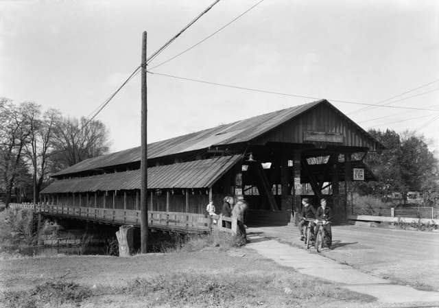
Photo: Carl Waite, Library of Congress Prints & Photographs Division (Historic American Buildings Survey), public domain · Wikimedia Commons
Local history sources: en.wikipedia.org · en.wikipedia.org · en.wikipedia.org · archive.org
Water
East Branch Mahoning River The water here
- Newton Falls City81% of residentsEast Branch Mahoning River
- Lordstown Village11% of residentsMeander Creek Reservoir (via MVSD, blended w/ Mosquito Lake)
- Warren City3% of residentsMosquito Creek Lake (Mosquito Creek Reservoir)
- Trumbull Co. - Bazetta/champion2% of residentsMosquito Creek Lake (Mosquito Creek Reservoir)
- Trumbull Co. - Braceville Twp2% of residentsEast Branch Mahoning River
- Pleasant Park Mobile Court0% of residentsGroundwater wells (1 wells)
- Belle Acres Mobile Home Park0% of residentsGroundwater wells (1 wells)
Hospitals, fire stations and more
Inside Newton Township, Trumbull County's boundary: 1 nursing home, 3 poor-rated bridges, 5 shale and injection wells, 1 Toxics Release Inventory facility and 6 spill cases. Press a pin or a name for its whole record and its source.
Nursing homes (1)
-
Laurie Ann Nursing Home3 of 5 stars · Newton Falls
- Address
- 2200 Milton Boulevard, Newton Falls, OH 44444
- Certified beds
- 60
- Residents on an average day
- 55
- Medicare overall rating
- 3 of 5 stars
- Health inspections
- 3 of 5 stars
- Staffing
- 3 of 5 stars
- Quality measures
- 3 of 5 stars
- Penalties since 2023
- none
- Ownership
- For profit - Limited Liability company
- Chain
- COUNTRY CLUB REHABILITATION CAMPUS
- Continuing care retirement community
- Yes
- Takes
- Medicare and Medicaid
- Phone
- (330) 872-1990
- Medicare ID
- 365855
- Map point
- the ZIP's center (the address did not geocode)
Medicare Care Compare ↗ CMS nursing home data (source) ↗ Street map and directions ↗
Source: CMS Care Compare nursing home provider and penalties files; Medicare star ratings run 1 to 5.
Bridges rated poor (3)
-
I80 Oh Tpk over Csx RrPoor · built 1954
- Condition
- Poor: a deck, superstructure, substructure or culvert rated 4 or below on the 0 to 9 scale
- What it is
- Bridge
- Built
- 1954
- Length
- 106 ft
- Owner
- Other
- Vehicles a day
- 35,398
- Coordinates
- 41.18681, -80.93443
National Bridge Inventory (source) ↗ Street map and directions ↗
-
Selkirk-Bush Rd over Duck CreekPoor · built 1954
- Condition
- Poor: a deck, superstructure, substructure or culvert rated 4 or below on the 0 to 9 scale
- What it is
- Bridge
- Built
- 1954
- Length
- 13 ft
- Owner
- County
- Vehicles a day
- 257
- Coordinates
- 41.17833, -80.91906
National Bridge Inventory (source) ↗ Street map and directions ↗
-
Wood-Lenhart Rd over Duck CreekPoor · built 1969
- Condition
- Poor: a deck, superstructure, substructure or culvert rated 4 or below on the 0 to 9 scale
- What it is
- Bridge
- Built
- 1969
- Length
- 18 ft
- Owner
- County
- Vehicles a day
- 153
- Coordinates
- 41.19504, -80.90598
National Bridge Inventory (source) ↗ Street map and directions ↗
Source: FHWA National Bridge Inventory 2025. "Poor" means one major part rated 4 or below on the 0 to 9 scale; it calls for repair, not closing, unless the state posts or closes the bridge.
Shale and injection wells (5)
-
Eva Root Wolf {Swiw#6} 1 InjectionInjection well (Class II)
- What it is
- Injection well (Class II)
- Operator
- Select Water Solutions, Llc
- County
- Trumbull County
- API well number
- 34155218930000
- Coordinates
- 41.20122, -80.99849
ODNR oil and gas wells (source) ↗ Street map and directions ↗
-
Pander R & P (Swiw #15) 1 InjectionInjection well (Class II)
- What it is
- Injection well (Class II)
- Operator
- Select Water Solutions, Llc
- County
- Trumbull County
- API well number
- 34155237950000
- Coordinates
- 41.20044, -80.99160
ODNR oil and gas wells (source) ↗ Street map and directions ↗
-
Pander R & P (Swiw #16) 2 InjectionInjection well (Class II)
- What it is
- Injection well (Class II)
- Operator
- Select Water Solutions, Llc
- County
- Trumbull County
- API well number
- 34155237940000
- Coordinates
- 41.19882, -80.99389
ODNR oil and gas wells (source) ↗ Street map and directions ↗
-
Wolf Root Eva Jean (Swiw#12) 4 InjectionInjection well (Class II)
- What it is
- Injection well (Class II)
- Operator
- Select Water Solutions, Llc
- County
- Trumbull County
- API well number
- 34155232030000
- Coordinates
- 41.20229, -81.00217
ODNR oil and gas wells (source) ↗ Street map and directions ↗
-
Wolf-Root {Swiw #13} 2 InjectionInjection well (Class II)
- What it is
- Injection well (Class II)
- Operator
- Select Water Solutions, Llc
- County
- Trumbull County
- API well number
- 34155218940000
- Coordinates
- 41.19833, -81.00026
ODNR oil and gas wells (source) ↗ Street map and directions ↗
Source: ODNR Division of Oil and Gas Resources well inventory (September 2026): drilled Utica, Marcellus and horizontal wells and Class II injection wells not plugged. Older vertical wells are on the full map.
Facilities reporting toxic releases (1)
-
Thermatex CorpToxics Release Inventory · Newton Falls
- Address
- 4521 Warren Ave., Newton Falls, OH 44444
- County
- Trumbull County
- Status
- Reports to the Toxics Release Inventory (active)
- EPA program ID
- 44444THRMT4521W
- EPA registry ID
- 110002111731
EPA facility record ↗ EPA Facility Registry Service (source) ↗ Street map and directions ↗
Source: EPA Facility Registry Service, Toxics Release Inventory reporters. Reporting a release is required of large users of listed chemicals; it is not by itself a violation.
Spills reported since 2021 (6)
-
Fuel Oil/ Home Heating / Heating Oil Reached water2025-12-29 · Newton Twp
- Reported
- 2025-12-29
- What spilled
- Fuel Oil/ Home Heating / Heating Oil
- Largest amount reported
- 300 gallons
- Reached a waterway
- 99 - Unnamed
- Where
- Newton Twp, Trumbull County
- Ohio EPA district office
- NEDO
- Ohio EPA case number
- 2512EPA0002069
Ohio EPA spill reports (source) ↗ Street map and directions ↗
-
Fuel Oil/ Home Heating / Heating Oil2022-10-26 · Newton Twp
- Reported
- 2022-10-26
- What spilled
- Fuel Oil/ Home Heating / Heating Oil
- Where
- Newton Twp, Trumbull County
- Ohio EPA district office
- NEDO
- Ohio EPA case number
- 2210EPA0001603
Ohio EPA spill reports (source) ↗ Street map and directions ↗
-
Fuel Diesel / Diesel Fuel (Vehicle On Or Off Road)2021-05-29 · Newton Twp
- Reported
- 2021-05-29
- What spilled
- Fuel Diesel / Diesel Fuel (Vehicle On Or Off Road)
- Largest amount reported
- 50 gallons
- Where
- Newton Twp, Trumbull County
- Ohio EPA district office
- NEDO
- Ohio EPA case number
- 2105EPA0000764
Ohio EPA spill reports (source) ↗ Street map and directions ↗
-
Foam2021-03-10 · Newton Twp
- Reported
- 2021-03-10
- What spilled
- Foam
- Largest amount reported
- 35 gallons
- Where
- Newton Twp, Trumbull County
- Ohio EPA district office
- NEDO
- Ohio EPA case number
- 2103EPA0000304
Ohio EPA spill reports (source) ↗ Street map and directions ↗
-
Fuel Diesel / Diesel Fuel (Vehicle On Or Off Road)2021-02-07 · Newton Twp
- Reported
- 2021-02-07
- What spilled
- Fuel Diesel / Diesel Fuel (Vehicle On Or Off Road)
- Where
- Newton Twp, Trumbull County
- Ohio EPA district office
- NEDO
- Ohio EPA case number
- 2102EPA0000172
Ohio EPA spill reports (source) ↗ Street map and directions ↗
-
Oil Motor / Lube Oil / Vehicle2026-04-29 · Newton Twp
- Reported
- 2026-04-29
- What spilled
- Oil Motor / Lube Oil / Vehicle
- Largest amount reported
- 1 gallons
- Where
- Newton Twp, Trumbull County
- Ohio EPA district office
- NEDO
- Ohio EPA case number
- 2604EPA0000722
Ohio EPA spill reports (source) ↗ Street map and directions ↗
Source: Ohio EPA emergency response spill reports, 2021 to September 2026, one point per case where Ohio EPA placed it. A report is what the caller or responder recorded; amounts are often blank or estimated.
Its ZIP codes
Each ZIP code that touches Newton Township, Trumbull County, with the share of its residents who live here and the same headline figures as the ZIP page.
| ZIP | Share | Water | Radon | Home value | Schools | Flood |
|---|---|---|---|---|---|---|
| 44444 Newton Falls | 31% | East Branch Mahoning River | 3.1 pCi/L average radon | Median year built 1953 | Newton Falls Exempted Village · 3.5 stars overall | 3.7% of residents in the 1% floodplain |
| 44481 Lordstown and Warren | 9% | Mostly private wells | 3.5 pCi/L average radon | Median year built 1973 | Lordstown Local · 3.5 stars overall | 2.4% of residents in the 1% floodplain |
Local government
Who holds office in Newton Township, Trumbull County, how its elections and ballot issues came out and the state auditor's record.
Who holds office
| Office | Name | Party | Term ends | Contact |
|---|---|---|---|---|
| Trustee | JOHN J. NEMET | 12/31/2027 | 2611 AMHERST AVE NEWTON FALLS, OH 44444-1884 | |
| Trustee | DOREEN LUTZ | 12/31/2029 | 5606 CHARLESTON RD, NEWTON FALLS, OH 44444 | |
| Trustee | PETER J. AUGUSTA | 12/31/2029 | 3267 MCMULLEN ALLEN RD, NEWTON FALLS, OH 44444 | |
| Fiscal officer | SUSAN D. MONTGOMERY | 3/31/2028 | 3179 STATE ROUTE 534, NEWTON FALLS, OH 44444 |
Roster as of 2026-08-24: official county or city website.
Money issues on the ballot since 2023: 1 of 1 passed.
Ballot issues
| Date | Issue | For | Against | Result |
|---|---|---|---|---|
| 2023-11-07 | Issue: Newton Twp Cemeteries Renewal 0.5 mill 5 years (0.5 mills, renewal) | 1,592 | 1,038 | Passed (60.53% for) |
Elections for office
| Date | Office | Candidates and votes |
|---|---|---|
| 2025-11-04 | Township Trustees | Peter J. Augusta 1,102, 56.75%; Doreen Lutz 840, 43.25% |
| 2023-11-07 | Township Trustee | John J. Nemet 2,111, 100.0% |
| 2023-11-07 | Township Fiscal Officer | Tim Irons 869, 36.36%; Susan D. Montgomery 1,521, 63.64% |
| 2021-11-02 | Township Trustees | Peter J. Augusta 983, 39.32%; Patti Hanzes 477, 19.08%; Doreen Lutz 759, 30.36%; Dennis Richter 281, 11.24% |
| 2019-11-06 | Twp Trustee | Keith J. Callihan 671, 32.8%; John R. Nemet 1,219, 59.58%; Write-In: Patti Hanzes 153, 7.48%; Not Assigned 3, 0.15% |
| 2019-11-06 | Twp Fiscal Officer | Susan D. Montgomery 1,180, 57.7%; Jennifer L. Young-Urbania 865, 42.3% |
| 2017-11-07 | Trustee (number of seats not on file, so winners are not marked) | Augusta, Peter J. 1,186, 36.36%; Irons, Bill 362, 11.1%; Lutz, Doreen 772, 23.67%; Rapczak, David 495, 15.17%; Richter, Dennis A. 447, 13.7% |
| 2015-11-03 | Trustee | Dubos, Greg 1,284, 44.88%; Nemet, John R. 1,577, 55.12% |
| 2015-11-03 | Fiscal Officer | Montgomery, Susan D. 1,506, 53.56%; Perkovich, Andrea 1,306, 46.44% |
Winners in bold. Results from the county board of elections' official canvass unless marked. The county's results on file run through 2026-02-03; later elections are not loaded yet.
Auditor of State record
- Fiscal caution: declared 2012-10-09, released 2018-11-20. source
- Agreed Upon Procedures, 2024 to 2025, released 2026-09-15
- Financial Audit, 2022 to 2023, released 2025-02-06
On the November 3, 2026 ballot
Statewide question: State Issue 3: Voter ID
Local questions for Newton Township, Trumbull County, Trumbull County and its school district:
- Newton Township: Miscellaneous, for Gas aggregation.
Races, candidates and every question for an address: your ballot. County offices and judges are on your county board's sample ballot.
The county
Trumbull County: 25 ZIP codes, 32 cities, villages and townships with pages here, 198,972 people (Census Bureau estimate, July 2025).
Nearby places
Quick answers
What county is Newton Township, Ohio in?
Newton Township, Trumbull County is a township in Trumbull County, Ohio, with 4,061 residents.
When was Newton Township, Ohio founded?
Newton Township, Trumbull County was settled 1802 (Alexander Sutherland, Duck Creek settlement); incorporated 1808 (Wikipedia gives 1806). Founders on record: Alexander Sutherland, first documented settler, at Duck Creek in 1802. Source
How did Newton Township, Ohio get its name?
The 1882 county history states plainly that 'why the township was called Newton is not now known, unless it was so called in honor of Sir Isaac Newton, the great philosopher' -- a guess, not a confirmed origin. Source
What ZIP code is Newton Township, Ohio?
Newton Township, Trumbull County is served by ZIP codes 44444 and 44481; 44444 holds the largest share of its residents.
Where does Newton Township, Ohio get its water?
The main water source for Newton Township, Trumbull County (Newton Falls City): East Branch Mahoning River.
Cite this page
Cite this page as:
Cracked Buckeye, "Newton Township, Trumbull County", https://crackedbuckeye.com/place/newton-township-trumbull-county/, built 2026-11-02, accessed [date].
How to cite · Report a correction · Built 2026-11-02