How Licking Township, Licking County began
Licking Township was organized in 1801 as a township of Fairfield County, and at first embraced almost the entire territory that later became Licking County; it lost land repeatedly as Granville (1807), Union and Bowling Green (1808), Newark (1810) and Franklin (1812) townships were carved from it, leaving it the smaller, southeastern township it is today. Its most striking landmark, Black Hand Gorge on the Licking River near Toboso, took its name from a petroglyph of a spread hand carved into the gorge's sandstone wall, a marker that by tradition guaranteed safe passage to all who traveled the trail to the Flint Ridge quarries; the carving was destroyed in 1828 during construction of the Ohio and Erie Canal through the gorge. The township's own stone and earth mounds, the largest of them examined by a Yale professor in the 1870s, and its long stretch of the Ohio Canal and the National Road, mark its early importance as a crossing point for both ancient and pioneer travelers. Jacksontown, platted along the National Road in the fervor of Andrew Jackson's 1828 presidential campaign, remains its only village.
Settled 1800-1801 (Phillip Sutton, Job Rathbone, and John and George Gillespie), incorporated 1801, as a township of Fairfield County.
Where the name comes from
The township takes its name from the Licking River, which forms its western boundary; no source consulted gives a founding-era explanation beyond the obvious geographic one. The river's own name is traditionally tied to salt licks along its course, but that derivation was not verified against a source for this file.
Before the town
The 1881 county history describes an Indian trail running through the township and along the Reservoir, from the mouth of the Wakatomika (near Dresden) across the Licking River near the Bowling Green run, to King Beaver's town near Pickerington or Lithopolis in Fairfield County; it states as "a well authenticated fact" that the Wyandot, Lenape (Delaware) and "perhaps" Shawnee kept more permanent homes along this trail than casual travel would suggest, though it adds that little of Indian history before white settlement can be known with certainty. Indians are recorded camping on the farm of J. R. Moore, and using a large sugar grove near Hog Run (later Jacob Brownfield's property) to make maple sugar. "Big swamp," also called "Two lakes," "Big lake" and "Little lake" by the Indians, and now known as the Reservoir, was resorted to by them in considerable numbers for fishing. This same trail is believed to be the route followed by trader Christopher Gist and Andrew Montour, son of a Seneca chief, in 1751, probably the first white men to pass through what became Licking Township. The township's most distinctive Native site was the Black Hand, a petroglyph of a spread hand carved into the sandstone wall of the gorge that bears its name; local tradition held that its long, pointing finger indicated a nearby mound and that the mark meant travelers bound for the Flint Ridge quarries to the south had to pass through the gorge in peace. The carving was destroyed in 1828 during construction of the Ohio and Erie Canal, and what other petroglyphs survived nearby were blasted away in 1890 during construction of an electric interurban railway tunnel through the gorge.
Nations recorded here: Wyandot, Lenape (Delaware), Shawnee.
- Black Hand petroglyph (other) — sandstone cliff face in Black Hand Gorge (Blackhand Gorge), on the Licking River near Toboso, prehistoric through 1828 (en.wikipedia.org)
- Great stone mound near Jacksontown (mound) — about a mile south of Jacksontown, Mound Builder era (unspecified) (archive.org)
- Mound examined by Professor Marsh (mound) — on the plank road between Newark and Jacksontown, on the Taylor farm, Mound Builder era (unspecified) (archive.org)
- Cochran's Hill enclosure (earthwork) — near the South Fork of the Licking, two miles from Newark, Mound Builder era (unspecified) (archive.org)
Timeline
- — Trader Christopher Gist and Andrew Montour, son of a Seneca chief, pass through the township on an Indian trail along the Licking, probably the first white men to do so.
- — Phillip Sutton, Job Rathbone, and John and George Gillespie settle in 1801, followed by Benjamin Green, Richard Pitzer and John Stadden in 1802, and Major Anthony Pitzer, Jacob Swisher and Stephen Robinson in 1803.
- — Licking Township is organized as a township of Fairfield County, at first embracing nearly the whole territory that will become Licking County.
- — Rev. Asa Shinn, a young Methodist circuit rider, preaches for a year at Benjamin Green's cabin on Hog Run, in what the county history calls "doubtless, the pioneer religious society of Licking county."
- — Granville Township (1807), Union and Bowling Green townships (1808), Newark Township (1810) and Franklin Township (1812) are successively organized out of Licking Township's original territory, reducing it to its present size.
- — The Ohio and Erie Canal is built through Black Hand Gorge, requiring a stone towpath blasted into the gorge walls; the Black Hand petroglyph is destroyed in 1828 during this construction.
- — The National Road is surveyed, graded and macadamized through the township from east to west.
- — Thomas Harris lays out the village of Jacksontown along the National Road, naming it for Andrew Jackson during the year of Jackson's first successful presidential campaign.
- — Professor O. C. Marsh of Yale College conducts an unusually thorough excavation of an earth mound on the Taylor farm, publishing his findings in Silliman's Journal.
- — Blasting for an electric interurban railway tunnel through Black Hand Gorge destroys the last traces of the area's remaining prehistoric rock carvings.
- — Charles Mangold photographs the north end of the interurban tunnel through Black Hand Gorge, near Toboso.
Stories
A Mound Opened by a Yale Professor
Of all the mounds explored in Licking Township, none received a more thorough examination than the earth mound on the Taylor farm, between Newark and Jacksontown, opened by Professor O. C. Marsh of Yale College. Marsh's dig turned up ashes, charcoal, flint, a broken limestone pipe, a string of more than a hundred native copper beads strung on twisted vegetable-fiber cord, shell beads, decayed layers of reddish powder, six hand axes of hematite and greenstone, bone needles three to six inches long, a whistle carved from a young black bear's tooth, and the remains of seventeen human skeletons, along with animal bones from elk, deer, rabbit, wolf, woodchuck and river mussel. He published his findings in Silliman's Journal and in a separate pamphlet, and Harvard's G. P. Russell joined a group of Newark gentlemen in assisting the excavation, later keeping some of the finds himself. The 1881 county history called the exploration "more perfect and thorough than that of any other within the limits of the county," a rare case of a Licking County mound examined with real scientific care rather than plowed away or dug into for buried treasure that was never there.
The Black Hand and the Peace of the Gorge
Cut into the sandstone cliff of the gorge that still bears its name, the Black Hand was a petroglyph of a hand with spread fingers and part of a wrist, one elongated finger reportedly pointing toward a nearby mound. Scholars who studied it before its destruction believed the carving marked the gorge as neutral ground: all the nations traveling to the Flint Ridge quarries a few miles south, to trade for or quarry the colorful flint prized across the eastern woodlands, were required to pass through the narrow gorge in peace. That truce marker did not survive the arrival of industrial Ohio. In 1828, workers blasting a towpath into the gorge's sandstone walls for the Ohio and Erie Canal destroyed the Black Hand itself, and in 1890 further blasting, this time to drive a tunnel for an electric interurban railway, removed the last traces of whatever fainter carvings had survived nearby. What remains today is the name alone, carried by the gorge, the state nature preserve, and the sandstone formation geologists call Black Hand Sandstone.
General Jackson's Namesake Town
In one of the years between 1825 and 1835, while crews were grading and macadamizing the new National Road through the township, landowner Thomas Harris platted a village along its route and named it Jacksontown, after Andrew Jackson, the hero of the Battle of New Orleans and the successful presidential candidate of 1828 (and again in 1832). Harris, the 1881 county history notes, was "a zealous Jacksonian, especially in the campaign of 1828." The new town started off at what the historian called "a lively pace" and soon became a modest post town, but it never grew much beyond the roughly three hundred people who lived there decades later. It remains the township's only village.
Photographs
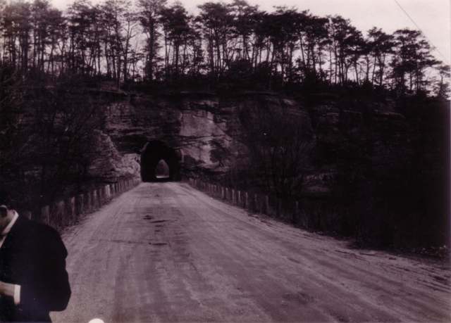
Photo: Charles Mangold, CC BY-SA 3.0 · Wikimedia Commons
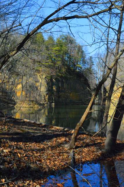
Photo: Paula R. Lively, via Wikimedia Commons, CC BY 2.0 · Wikimedia Commons
Local history sources: archive.org · en.wikipedia.org · en.wikipedia.org · commons.wikimedia.org · commons.wikimedia.org
Water
Mostly private wells The water here
- City of Heath54% of residentslocal wells
- Hebron Village19% of residentsGroundwater wells (4 wells)
- Thornville, Village Of8% of residentsGroundwater wells (2 wells)
- Northern Perry Co.water #17% of residentsGroundwater wells (2 wells)
- Buckeye Lake, Village Of6% of residentsGroundwater wells (4 wells)
- Licking County Harbor Hills5% of residentsGroundwater wells (4 wells)
- Villa Vista Mobile Home1% of residentsGroundwater wells (2 wells)
- Roberts Trailer Park0% of residentsGroundwater wells (1 wells)
- Muskingum County Water - Se0% of residentsMuskingum River buried valley aquifer (wells near Duncan Falls)
Its ZIP codes
Each ZIP code that touches Licking Township, Licking County, with the share of its residents who live here and the same headline figures as the ZIP page.
| ZIP | Share | Water | Radon | Home value | Schools | Flood |
|---|---|---|---|---|---|---|
| 43030 Licking Township and Jacksontown | 100% | Mostly private wells | 5.9 pCi/L average radon | Median year built 1949 | Lakewood Local · 3.5 stars overall | 0.0% of residents in the 1% floodplain |
| 43025 Hebron | 15% | Groundwater wells (4 wells) | 9.2 pCi/L average radon | Median year built 1980 | Lakewood Local · 3.5 stars overall | 14% of residents in the 1% floodplain |
| 43076 Thorn Township and Thornville | 15% | Mostly private wells | 7.3 pCi/L average radon | Median year built 1983 | Northern Local · 3 stars overall | 0.6% of residents in the 1% floodplain |
| 43056 Heath | 12% | Mostly private wells | 8.8 pCi/L average radon | Median year built 1978 | Heath City · 4 stars overall | 5.8% of residents in the 1% floodplain |
The county
Licking County: 17 ZIP codes, 38 cities, villages and townships, 160,939 people.
Nearby places
Cite this page
Cite this page as:
Cracked Buckeye (Open Shower Co), "Licking Township, Licking County", https://crackedbuckeye.com/place/licking-township-licking-county/, built 2026-09-16, accessed [date].
Machine-readable: /api/place/licking-township-licking-county.json (open JSON, CC BY 4.0 for the compilation; the underlying records keep their own terms) · How to cite · Report a correction · Built 2026-09-16