How Perry Township, Franklin County began
Perry Township was organized in 1820 from land whose original grants under the Virginia Military District went to Elijah Backus, Jonathan Dayton and Andrew Marker, and which passed to farm families through the 1800s. Its most consequential change came in 1913, when developers King and Ben Thompson bought 840 acres of township farmland south of Lane Avenue and began building the planned suburb that became Upper Arlington. Columbus, Dublin, Upper Arlington and Worthington have since annexed almost all of the original township, leaving Perry Township today as a set of small unincorporated islands with about 2.2 square miles of land in total.
Settled not precisely dated in sources checked; the land's original Virginia Military District grants went to Elijah Backus, Jonathan Dayton and Andrew Marker and were sold off to farm families through the 1800s, incorporated 1820, by not specified in sources checked.
Where the name comes from
No source found gives an explicit origin for this township's name. Perry Township, Franklin County, was organized in 1820, one of twenty-six townships of that name in Ohio; a same-named township in Morrow County is documented as having been renamed to honor Commodore Oliver Hazard Perry, but no source confirms that connection for this specific township.
Before the town
According to Upper Arlington's history (Upper Arlington was incorporated out of Perry Township land in 1918), this ground was 'first known to be inhabited by the Adena people,' and Wyandot people lived here before being displaced as the U.S. government issued Revolutionary War land-bounty grants that were surveyed and sold from the 1790s onward. No specific village, mound or trail within Perry Township is named in the sources checked. Broader county-wide Native American context belongs in the Franklin County file.
Nations recorded here: Wyandot, Adena culture.
Timeline
- — The Adena culture is the earliest people documented as inhabiting the ground later organized as Perry Township, according to Upper Arlington's local history.
- — Wyandot presence in the area gives way as the U.S. government surveys and issues Revolutionary War land-bounty grants, including tracts here awarded to Elijah Backus, Jonathan Dayton and Andrew Marker.
- — Perry Township is organized as a civil township of Franklin County.
- — Perry Township appears in Kilbourn's 'Ohio Gazetteer, or, a Topographical Dictionary.'
- — Columbus surveyor E. F. Wheeler draws a map of Perry Township, later preserved by the Columbus Metropolitan Library.
- — Developers King and Ben Thompson buy 840 acres of Perry Township farmland south of present-day Lane Avenue from James T. Miller, the start of what becomes Upper Arlington.
- — The Ohio National Guard occupies part of the new development as Camp Willis; the camp is dismantled by September 1916.
- — The Upper Arlington Company incorporates and renames the project, until then called the 'Country Club District,' Upper Arlington.
- — A stone entryway and new houses mark the development's entrance at Fifth Avenue and Cambridge Boulevard, as pictured in the Norwester magazine.
- — Upper Arlington incorporates as a village, carving the new suburb out of Perry Township.
- — The Upper Arlington Historic District, covering the Thompson brothers' original development, is listed on the National Register of Historic Places.
- — The house of Frederick G. Kilgour, founder of the library computer network OCLC, at 1415 Kirkley Road in Upper Arlington, is added to the National Register of Historic Places.
- — Perry Township's remaining unincorporated islands, about 2.2 square miles in total, record a population of 3,929.
Stories
Farmland into the Country Club District
In 1913, real-estate developers King Thompson and his brother Ben bought 840 acres of ordinary Perry Township farmland south of Lane Avenue from James T. Miller. They hired landscape architect William Pitkin Jr. to lay it out on the Garden City model then in vogue nationally, curving streets and deed restrictions and all, and began selling lots as the 'Country Club District.' The Thompsons' timing was awkward: in 1916 the Ohio National Guard set up Camp Willis on part of the unsold ground, mustering troops before the United States' entry into the First World War, and the camp had to be cleared before building could continue. By 1917 the developers had incorporated the Upper Arlington Company and renamed the project Upper Arlington, after its southern neighbor, the village of Arlington (now Marble Cliff). The new suburb incorporated as a village in its own right on March 20, 1918, complete with a stone gateway at Fifth Avenue and Cambridge Boulevard advertised in the Norwester magazine, and Perry Township never got that land back.
A township reduced to islands
Perry Township once covered a substantial block of Franklin County northwest of Columbus. Between the 1913 sale that produced Upper Arlington and the twentieth century's steady march of annexation by Columbus, Dublin and Worthington as well, the township's territory was cut away piece by piece. What remains today is not one place but several small, disconnected unincorporated pockets, some bordering Upper Arlington, some Dublin, some reaching north to the Delaware County line, together totaling about 2.2 square miles and just under 4,000 residents. The township still elects a three-member board of trustees and a fiscal officer, and keeps a police department and a town hall, even though most people who live within its old boundaries now have a Columbus, Dublin, Upper Arlington or Worthington address instead.
The librarian's house on Kirkley Road
Long after Upper Arlington had grown up on former Perry Township ground, one of its houses earned a National Register listing for a distinctly modern reason. Frederick G. Kilgour, a Harvard-trained chemist turned librarian, moved to central Ohio in 1967 to build what became OCLC, the Online Computer Library Center, out of the Ohio College Association. Working from Dublin, Ohio, Kilgour's team launched the first shared online library-cataloging system in 1971, letting Ohio academic libraries catalog a book once and share the record everywhere, a system that grew into WorldCat, now the world's largest computerized library catalog and the backbone of millions of interlibrary loans a year. Kilgour's house at 1415 Kirkley Road, in what had been Perry Township before Upper Arlington's incorporation, was added to the National Register of Historic Places on July 3, 2012, one of the newer listings tied to this stretch of the county.
Photographs
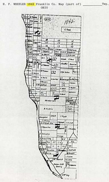
Photo: Columbus Metropolitan Library, via Digital Public Library of America / Ohio Digital Network, public domain · Wikimedia Commons
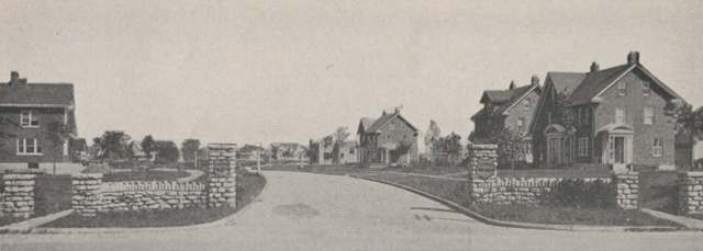
Photo: UA Archives / Upper Arlington Historical Society, via Upper Arlington Public Library, no known copyright restrictions · Wikimedia Commons
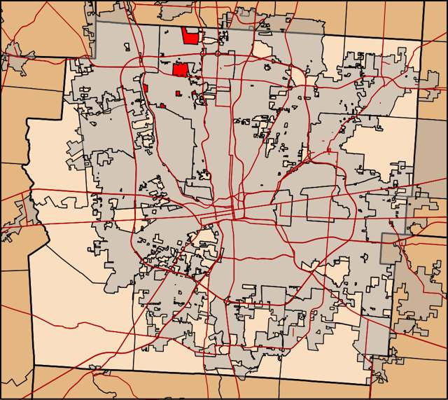
Photo: Ibagli, via Wikimedia Commons, CC0 · Wikimedia Commons
Local history sources: en.wikipedia.org · en.wikipedia.org · en.wikipedia.org · en.wikipedia.org · en.wikipedia.org · commons.wikimedia.org · commons.wikimedia.org · commons.wikimedia.org
Water
Big Walnut Creek at the plant's low-head dam and screen house on Morse Rd, below Hoover Dam The water here
- Columbus Public Water System94% of residentsScioto River (Griggs & O'Shaughnessy), Hoover Reservoir on Big Walnut Ck, plus wells
- Aqua Ohio - Worthington Hills6% of residentsGroundwater wells (3 wells)
Its ZIP codes
Each ZIP code that touches Perry Township, Franklin County, with the share of its residents who live here and the same headline figures as the ZIP page.
| ZIP | Share | Water | Radon | Home value | Schools | Flood |
|---|---|---|---|---|---|---|
| 43235 Columbus | 8% | Big Walnut Creek at the plant's low-head dam and screen house on Morse Rd, below Hoover Dam | 7.1 pCi/L average radon | Median year built 1986 | Worthington City · 4 stars overall | 0.1% of residents in the 1% floodplain |
| 43221 Upper Arlington and Columbus | 1% | Scioto River intake at the plant on Dublin Rd, a few miles below Griggs Dam, opposite Marble Cliff | 7.0 pCi/L average radon | Median year built 1959 | Upper Arlington City · 5 stars overall | 1.6% of residents in the 1% floodplain |
The county
Franklin County: 45 ZIP codes, 42 cities, villages and townships, 1,356,733 people.
Nearby places
Cite this page
Cite this page as:
Cracked Buckeye (Open Shower Co), "Perry Township, Franklin County", https://crackedbuckeye.com/place/perry-township-franklin-county/, built 2026-09-16, accessed [date].
Machine-readable: /api/place/perry-township-franklin-county.json (open JSON, CC BY 4.0 for the compilation; the underlying records keep their own terms) · How to cite · Report a correction · Built 2026-09-16