Local events in Brookfield Township, Noble County
Nothing is posted for Brookfield Township itself yet; here is what is on within 20 miles. All local events in Brookfield Township, Noble County
Know a calendar we should watch? Send the link
Checked October 20; the events page is refreshed daily.
How Brookfield Township, Noble County began
Brookfield Township, in the far western corner of Noble County, was settled beginning in 1806 by the sons of Revolutionary War veteran Ezekiel Dye along Dye's Fork of Meigs Creek, and was named for Brookfield, Massachusetts, by settler John Draper after he arrived from that state in 1817. It came into Noble County from Morgan County when Noble County was formed in 1851. The township never held a chartered village; its small settlements of Renrock and Hiramsburg grew up around a mill, a store, and a Baptist church. It remains agricultural and sparsely populated, with 112 residents at the 2020 census, one of the smallest townships in Ohio.
Settled 1806, by sons of Ezekiel Dye, first permanent settlers near Dye's Fork of Meigs Creek.
Where the name comes from
The township was named after Brookfield, Massachusetts, by John Draper, who arrived from that state in 1817. Draper later introduced Durham cattle to the township in 1834.
Before the town
No Native American village, trail, mound, or treaty line specific to Brookfield Township is recorded in the sources consulted (the 1887 Noble County history's Brookfield Township chapter, which is otherwise detailed about the township's early settlement, does not mention Native inhabitants or sites there). The land that became Noble County lay within the area ceded by the Treaty of Greenville (1795) and was hunted and traveled by Wyandot, Shawnee, Lenape (Delaware), and Mingo (Seneca-Cayuga) people before and after that cession.
Timeline
- — Sons of Ezekiel Dye (Thomas, Ezekiel, Vincent, William, John, and Amos) make the first permanent settlement in the township near Dye's Fork of Meigs Creek; Ezekiel Dye Sr., a Revolutionary War veteran from New Jersey who had bought the land in 1804, joins them in 1807.
- — Judge William Rannells, of Virginia, enters land in the township and moves his family there in 1810, becoming one of its most prominent early citizens.
- — John Draper arrives from Massachusetts and names the township Brookfield after his home town of Brookfield, Massachusetts.
- — Brookfield Baptist Church is organized on February 8; a log meeting house is built the following spring, in 1826.
- — A woolen mill begins operating at Renrock, on Dye's Fork, run by Bigger, Bush, and others.
- — The first store at Renrock is opened by a Mr. Bozman, from Morgan County; a post office is established there some years later.
- — Noble County is formed from parts of Guernsey, Monroe, Morgan, and Washington counties; Brookfield Township is transferred into the new county from Morgan County.
- — The U.S. Census records 112 residents in Brookfield Township, making it one of the three smallest townships in Ohio by population.
Stories
A township that never got a town
Brookfield Township has no incorporated village inside its 30.5 square miles, and never did. What passed for centers were Renrock, where a woolen mill ran from 1841 and a store opened in 1845, and Hiramsburg, where a school and a Baptist congregation took root. Early industry was homespun in the plainest sense: settlers David Green and Russell Prouty pressed castor oil from beans they grew themselves, horse-powered mills ground grain, and sawmills went up wherever a settler had timber and a creek. One of the township's first schools met in an old bean house on Linus Bacon's farm, without a floor. That thin, scattered pattern of farms, a mill hamlet, and a country church is essentially what Brookfield Township still is: agricultural, rural, and never built up.
Photographs
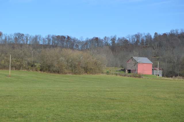
Photo: Nyttend, public domain · Wikimedia Commons
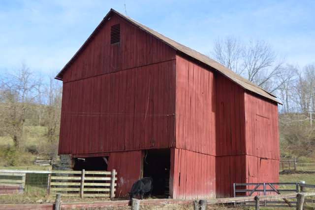
Photo: Nyttend, public domain · Wikimedia Commons
Local history sources: ohiogenealogyexpress.com · en.wikipedia.org · en.wikipedia.org · en.wikipedia.org · en.wikipedia.org · commons.wikimedia.org · commons.wikimedia.org · commons.wikimedia.org
Water
Mostly private wells The water here
- Caldwell Village77% of residentsWolf Run Lake (primary) + Caldwell Lake (backup reservoirs)
- Pure Water Corporation11% of residentsWolf Run Lake (primary) + Caldwell Lake (backup reservoirs)
- Noble County Water Authority5% of residentsWolf Run Lake (primary) + Caldwell Lake (backup reservoirs)
- Pure Water System 23% of residentsWolf Run Lake (primary) + Caldwell Lake (backup reservoirs)
- Pleasant City, Village Of2% of residentsGroundwater wells (2 wells)
- Noble Water Company2% of residentsWolf Run Lake (primary) + Caldwell Lake (backup reservoirs)
- Clear Water Corporation0% of residentsWolf Run Lake (primary) + Caldwell Lake (backup reservoirs)
Hospitals, fire stations and more
Inside Brookfield Township, Noble County's boundary: 21 shale and injection wells. Press a pin or a name for its whole record and its source.
Shale and injection wells (21)
-
Brookfield Nbk15 3AHorizontal shale well
- What it is
- Horizontal shale well
- Drilled sideways
- Yes
- Operator
- Eog Resources Inc.
- County
- Noble County
- API well number
- 34121246550000
- Coordinates
- 39.79946, -81.62857
ODNR oil and gas wells (source) ↗ Street map and directions ↗
The point is the surface well head (the pad); a horizontal well runs a mile or more underground from it.
-
Brookfield-No-15Se 1HpaUtica shale well
- What it is
- Utica shale well
- Drilled sideways
- Yes
- Operator
- Eog Resources Inc.
- County
- Noble County
- API well number
- 34121246490100
- Coordinates
- 39.79950, -81.62853
ODNR oil and gas wells (source) ↗ Street map and directions ↗
The point is the surface well head (the pad); a horizontal well runs a mile or more underground from it.
-
Deere Nbk 1BUtica shale well
- What it is
- Utica shale well
- Drilled sideways
- Yes
- Operator
- Eog Resources Inc.
- County
- Noble County
- API well number
- 34121246910000
- Coordinates
- 39.79331, -81.65129
ODNR oil and gas wells (source) ↗ Street map and directions ↗
The point is the surface well head (the pad); a horizontal well runs a mile or more underground from it.
-
Deere Nbk 3BUtica shale well
- What it is
- Utica shale well
- Drilled sideways
- Yes
- Operator
- Eog Resources Inc.
- County
- Noble County
- API well number
- 34121246920000
- Coordinates
- 39.79327, -81.65129
ODNR oil and gas wells (source) ↗ Street map and directions ↗
The point is the surface well head (the pad); a horizontal well runs a mile or more underground from it.
-
Deere Nbk 5BUtica shale well
- What it is
- Utica shale well
- Drilled sideways
- Yes
- Operator
- Eog Resources Inc.
- County
- Noble County
- API well number
- 34121246930000
- Coordinates
- 39.79322, -81.65129
ODNR oil and gas wells (source) ↗ Street map and directions ↗
The point is the surface well head (the pad); a horizontal well runs a mile or more underground from it.
-
Deere Nbk 7BUtica shale well
- What it is
- Utica shale well
- Drilled sideways
- Yes
- Operator
- Eog Resources Inc.
- County
- Noble County
- API well number
- 34121246940000
- Coordinates
- 39.79318, -81.65129
ODNR oil and gas wells (source) ↗ Street map and directions ↗
The point is the surface well head (the pad); a horizontal well runs a mile or more underground from it.
-
Frec Nobl Brookfield A-3HUtica shale well
- What it is
- Utica shale well
- Drilled sideways
- Yes
- Operator
- Eog Resources Inc.
- County
- Noble County
- API well number
- 34121243500100
- Coordinates
- 39.77991, -81.65681
ODNR oil and gas wells (source) ↗ Street map and directions ↗
The point is the surface well head (the pad); a horizontal well runs a mile or more underground from it.
-
Osprey Nbk 1CUtica shale well
- What it is
- Utica shale well
- Drilled sideways
- Yes
- Operator
- Eog Resources Inc.
- County
- Noble County
- API well number
- 34121246950000
- Coordinates
- 39.77360, -81.61541
ODNR oil and gas wells (source) ↗ Street map and directions ↗
The point is the surface well head (the pad); a horizontal well runs a mile or more underground from it.
-
Osprey Nbk 3CUtica shale well
- What it is
- Utica shale well
- Drilled sideways
- Yes
- Operator
- Eog Resources Inc.
- County
- Noble County
- API well number
- 34121246960000
- Coordinates
- 39.77360, -81.61547
ODNR oil and gas wells (source) ↗ Street map and directions ↗
The point is the surface well head (the pad); a horizontal well runs a mile or more underground from it.
-
Sable Nbk16 2AUtica shale well
- What it is
- Utica shale well
- Drilled sideways
- Yes
- Operator
- Eog Resources Inc.
- County
- Noble County
- API well number
- 34121246570000
- Coordinates
- 39.80078, -81.63878
ODNR oil and gas wells (source) ↗ Street map and directions ↗
The point is the surface well head (the pad); a horizontal well runs a mile or more underground from it.
-
Sable Nbk16 4AUtica shale well
- What it is
- Utica shale well
- Drilled sideways
- Yes
- Operator
- Eog Resources Inc.
- County
- Noble County
- API well number
- 34121246580000
- Coordinates
- 39.80076, -81.63883
ODNR oil and gas wells (source) ↗ Street map and directions ↗
The point is the surface well head (the pad); a horizontal well runs a mile or more underground from it.
-
Sable Nbk16 6AUtica shale well
- What it is
- Utica shale well
- Drilled sideways
- Yes
- Operator
- Eog Resources Inc.
- County
- Noble County
- API well number
- 34121246590000
- Coordinates
- 39.80075, -81.63888
ODNR oil and gas wells (source) ↗ Street map and directions ↗
The point is the surface well head (the pad); a horizontal well runs a mile or more underground from it.
-
Sable Nbk16 8AUtica shale well
- What it is
- Utica shale well
- Drilled sideways
- Yes
- Operator
- Eog Resources Inc.
- County
- Noble County
- API well number
- 34121246600000
- Coordinates
- 39.80074, -81.63893
ODNR oil and gas wells (source) ↗ Street map and directions ↗
The point is the surface well head (the pad); a horizontal well runs a mile or more underground from it.
-
White Rhino Nbk 11BUtica shale well
- What it is
- Utica shale well
- Drilled sideways
- Yes
- Operator
- Eog Resources Inc.
- County
- Noble County
- API well number
- 34121246740000
- Coordinates
- 39.79721, -81.61702
ODNR oil and gas wells (source) ↗ Street map and directions ↗
The point is the surface well head (the pad); a horizontal well runs a mile or more underground from it.
-
White Rhino Nbk 5BUtica shale well
- What it is
- Utica shale well
- Drilled sideways
- Yes
- Operator
- Eog Resources Inc.
- County
- Noble County
- API well number
- 34121246750000
- Coordinates
- 39.79718, -81.61685
ODNR oil and gas wells (source) ↗ Street map and directions ↗
The point is the surface well head (the pad); a horizontal well runs a mile or more underground from it.
-
White Rhino Nbk 7BUtica shale well
- What it is
- Utica shale well
- Drilled sideways
- Yes
- Operator
- Eog Resources Inc.
- County
- Noble County
- API well number
- 34121246720000
- Coordinates
- 39.79719, -81.61691
ODNR oil and gas wells (source) ↗ Street map and directions ↗
The point is the surface well head (the pad); a horizontal well runs a mile or more underground from it.
-
White Rhino Nbk 9BUtica shale well
- What it is
- Utica shale well
- Drilled sideways
- Yes
- Operator
- Eog Resources Inc.
- County
- Noble County
- API well number
- 34121246730000
- Coordinates
- 39.79720, -81.61696
ODNR oil and gas wells (source) ↗ Street map and directions ↗
The point is the surface well head (the pad); a horizontal well runs a mile or more underground from it.
-
White Rhino Nbk14 2AUtica shale well
- What it is
- Utica shale well
- Drilled sideways
- Yes
- Operator
- Eog Resources Inc.
- County
- Noble County
- API well number
- 34121246610000
- Coordinates
- 39.79724, -81.61716
ODNR oil and gas wells (source) ↗ Street map and directions ↗
The point is the surface well head (the pad); a horizontal well runs a mile or more underground from it.
-
White Rhino Nbk14 4AUtica shale well
- What it is
- Utica shale well
- Drilled sideways
- Yes
- Operator
- Eog Resources Inc.
- County
- Noble County
- API well number
- 34121246620000
- Coordinates
- 39.79724, -81.61721
ODNR oil and gas wells (source) ↗ Street map and directions ↗
The point is the surface well head (the pad); a horizontal well runs a mile or more underground from it.
-
White Rhino Nbk14 6AUtica shale well
- What it is
- Utica shale well
- Drilled sideways
- Yes
- Operator
- Eog Resources Inc.
- County
- Noble County
- API well number
- 34121246630000
- Coordinates
- 39.79725, -81.61726
ODNR oil and gas wells (source) ↗ Street map and directions ↗
The point is the surface well head (the pad); a horizontal well runs a mile or more underground from it.
-
White Rhino Nbk14 8AUtica shale well
- What it is
- Utica shale well
- Drilled sideways
- Yes
- Operator
- Eog Resources Inc.
- County
- Noble County
- API well number
- 34121246640000
- Coordinates
- 39.79726, -81.61732
ODNR oil and gas wells (source) ↗ Street map and directions ↗
The point is the surface well head (the pad); a horizontal well runs a mile or more underground from it.
Source: ODNR Division of Oil and Gas Resources well inventory (September 2026): drilled Utica, Marcellus and horizontal wells and Class II injection wells not plugged. Older vertical wells are on the full map.
Its ZIP codes
Each ZIP code that touches Brookfield Township, Noble County, with the share of its residents who live here and the same headline figures as the ZIP page.
| ZIP | Share | Water | Radon | Home value | Schools | Flood |
|---|---|---|---|---|---|---|
| 43732 Spencer Township and Cumberland | 4% | Mostly private wells | 1.8 pCi/L average radon | Appraisal records without year built | Rolling Hills Local · 3.5 stars overall | 1.5% of residents in the 1% floodplain |
| 43724 Olive Township and Caldwell | 1% | Mostly private wells | 8.2 pCi/L average radon | Appraisal records without year built | Caldwell Exempted Village · 3 stars overall | 2.8% of residents in the 1% floodplain |
The county
Guernsey County: 14 ZIP codes, 32 cities, villages and townships, 39,085 people.
Nearby places
Quick answers
What county is Brookfield Township, Ohio in?
Brookfield Township, Noble County is a township in Guernsey County, Ohio, with 112 residents.
When was Brookfield Township, Ohio founded?
Brookfield Township, Noble County was settled 1806. Founders on record: sons of Ezekiel Dye, first permanent settlers near Dye's Fork of Meigs Creek. Source
How did Brookfield Township, Ohio get its name?
The township was named after Brookfield, Massachusetts, by John Draper, who arrived from that state in 1817. Source
What ZIP code is Brookfield Township, Ohio?
Most of Brookfield Township, Noble County is in ZIP code 43732.
Where does Brookfield Township, Ohio get its water?
The main water source for Brookfield Township, Noble County (Caldwell Village): Mostly private wells.
Cite this page
Cite this page as:
Cracked Buckeye, "Brookfield Township, Noble County", https://crackedbuckeye.com/place/brookfield-township-noble-county/, built 2026-10-31, accessed [date].
How to cite · Report a correction · Built 2026-10-31