Local events in Buffalo Township, Noble County
Nothing is posted for Buffalo Township itself yet; here is what is on within 10 miles. All local events in Buffalo Township, Noble County
Know a calendar we should watch? Send the link
Checked October 20; the events page is refreshed daily.
How Buffalo Township, Noble County began
Buffalo Township, in the northern part of Noble County, traces to a Buffalo Township that Guernsey County erected on June 5, 1810, which then covered much of the northwest of the present county. The land was surveyed by John Beaver in 1798 and sectioned by William R. Putnam in 1805; Jacob Gregg entered a quarter-section about 1806, and in the spring of 1810 Abraham Rich and Abraham and John Miley built a camp and lived through the winter mostly on potatoes, followed about 1812 by a group of Virginia families who had been neighbors at home. The township was cut down when Morgan County was formed in 1819 and split again in 1851, leaving twelve sections in Guernsey County and twenty-four in Noble. It has no village; its best-known ground is the farm where the control car of the Navy airship USS Shenandoah fell on September 3, 1925. The 2020 census counted 885 residents.
Settled about 1806 (Jacob Gregg); spring 1810 (Abraham Rich and the Miley brothers), incorporated erected June 5, 1810 in Guernsey County; re-erected in Noble County May 1, 1851, by Guernsey County commissioners, on a petition of inhabitants; later the Noble County commissioners.
Where the name comes from
The township carries forward the name of the original Buffalo Township organized in Guernsey County in 1810, a name common across early Ohio townships for the American bison once found in the region; no source specific to this township's naming beyond that lineage was found.
Before the town
No Native American village, mound, trail or camp inside the present Buffalo Township is recorded in the sources read. The 1810 Buffalo Township of Guernsey County, however, took in what is now Noble Township to the south, and there the 1887 county history describes an Indian trail along the West Fork of Duck Creek, worn buffalo paths still visible after settlement, Native hunters frequenting the valley until about the War of 1812, and a recently used Indian camp that John Noble found standing on the creek bank when he arrived in 1812. When Abraham Rich and the Mileys camped here in 1810 they blazed trees toward Washington and Barnesville for friends expected from Pennsylvania.
Nations recorded here: Wyandot, Shawnee, Lenape (Delaware), Mingo (Seneca-Cayuga), Miami.
Timeline
- — The township, township 8 of range 9, was surveyed by John Beaver.
- — William R. Putnam divided the township into sections.
- — Jacob Gregg came from Washington County, Pennsylvania, about this year and entered 160 acres; he died about 1853.
- — In the spring Abraham Rich, then a boy, and Abraham and John Miley built a camp, cleared a patch and raised potatoes, living on them through the winter; John and George Rich joined them the next year.
- — Guernsey County granted a petition for a new township called Buffalo and ordered an election for two justices at the house of Jacob Jordan, near Hiramsburg, on June 23.
- — Several Virginia families who had been neighbors at home, among them Levi Lyons, John Drake, George R. Johnson, Abraham Booher and Samuel and Isaac Kackley, settled together in the township about this year.
- — Jacob Shriver, from Greene County, Pennsylvania, arrived with his family at the cabin he had built the year before.
- — Part of the township was removed to help form a portion of the newly created Morgan County.
- — Jacob Larrick settled about this year and later ran an early horse-powered grist mill and a sawmill.
- — A Methodist class was formed, meeting in houses and schoolhouses, with Abraham Rich as its first class leader.
- — The Guernsey County tax duplicate listed 11,791 acres in the full 36-section township, valued at $19,146, with a total tax of $192.93.
- — A revival added many members to the Methodist churches of the area and produced a large number of local preachers in Buffalo and Seneca townships.
- — The Methodists built a brick meeting-house in the eastern part of the township, still in use in 1887.
- — Noble County was organized on March 11, and Buffalo Township was divided, leaving part in Guernsey County and the remainder as Buffalo Township, Noble County, erected May 1 with twenty-four sections.
- — John Stevens qualified as the first justice of the peace of the new township.
- — The census counted 804 people in Buffalo Township.
- — On September 3, the Navy rigid airship USS Shenandoah broke apart in severe squalls; its control car, with commander Zachary Lansdowne and six other crewmen still aboard, fell in Section 33 of Buffalo Township onto the Gamary farm, killing all seven.
- — The Shenandoah crash sites in Buffalo, Noble and Sharon Townships were together listed on the National Register of Historic Places on July 25.
Stories
Where the control car came down
Of the three sections the USS Shenandoah broke into over Noble County on the morning of September 3, 1925, the deadliest was the control car, which separated from the bow and fell to earth on the Gamary family farm in Section 33 of Buffalo Township. Commander Zachary Lansdowne and six other crewmen were still aboard; none survived. The site, along with the stern section that drifted nearly a mile southwest into neighboring Noble Township, was listed on the National Register of Historic Places in 1989 as the Shenandoah Crash Sites, one of the rare National Register listings commemorating an aviation disaster rather than a building.
America's first helium airship
The Ohio History Connection's marker for the crash, which stands near Ava, says the Shenandoah was America's first rigid dirigible, launched in 1923, and the first rigid airship in the world to be filled with nonflammable helium instead of hydrogen. It was 680 feet long and had begun a six-day publicity tour of the Midwest when late-summer storms tore it in two and ripped the control car from the keel. Fourteen crewmen died, most of them, including the captain, Lieutenant Commander Zachary Lansdowne of Greenville, Ohio, in the fall of the control car. The Ohio National Guard was called out to control the crowds who came to see the wreckage.
Potatoes, blazed trees and horses that went home
The first white residents of the present township were probably Abraham Rich, Abraham Miley and John Miley, who came in the spring of 1810, built a camp, cleared a small patch and raised potatoes, and lived through the winter mostly on them. Expecting friends from Pennsylvania, they blazed trees toward Washington in Guernsey County and toward Barnesville so the newcomers could find the camp. John Rich, who joined them, soon lost two horses; after searching everywhere he heard that horses had swum the Ohio at Moundsville, went back to his old home in Greene County, Pennsylvania, and found them there. They had made their own way home through the wilderness.
Photographs
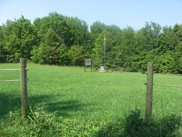
Photo: Nyttend, Public domain · Wikimedia Commons
Local history sources: en.wikipedia.org · nps.gov · en.wikipedia.org · en.wikipedia.org · en.wikipedia.org · archive.org · archive.org · archive.org · remarkableohio.org
Water
Mostly private wells The water here
- Pleasant City, Village Of100% of residentsGroundwater wells (2 wells)
Hospitals, fire stations and more
Inside Buffalo Township, Noble County's boundary: 2 poor-rated bridges and 9 shale and injection wells. Press a pin or a name for its whole record and its source.
Bridges rated poor (2)
-
Township Road 119 over North Fork Buffalo CreekPoor · built 2000
- Condition
- Poor: a deck, superstructure, substructure or culvert rated 4 or below on the 0 to 9 scale
- What it is
- Culvert
- Built
- 2000
- Length
- 11 ft
- Owner
- County
- Vehicles a day
- 209
- Coordinates
- 39.84943, -81.51892
National Bridge Inventory (source) ↗ Street map and directions ↗
-
Tr103 over Buffalo CreekPoor · built 1994
- Condition
- Poor: a deck, superstructure, substructure or culvert rated 4 or below on the 0 to 9 scale
- What it is
- Bridge
- Built
- 1994
- Length
- 17 ft
- Owner
- County
- Vehicles a day
- 209
- Coordinates
- 39.87915, -81.54226
National Bridge Inventory (source) ↗ Street map and directions ↗
Source: FHWA National Bridge Inventory 2025. "Poor" means one major part rated 4 or below on the 0 to 9 scale; it calls for repair, not closing, unless the state posts or closes the bridge.
Shale and injection wells (9)
-
Bearcats Nb Buf 10HUtica shale well
- What it is
- Utica shale well
- Drilled sideways
- Yes
- Operator
- Eog Ohio, Llc
- County
- Noble County
- API well number
- 34121246990000
- Coordinates
- 39.86115, -81.49080
ODNR oil and gas wells (source) ↗ Street map and directions ↗
The point is the surface well head (the pad); a horizontal well runs a mile or more underground from it.
-
Bearcats Nb Buf 210HUtica shale well · Drilling
- What it is
- Utica shale well
- Drilled sideways
- Yes
- Status (ODNR)
- Drilling
- Operator
- Eog Ohio, Llc
- County
- Noble County
- API well number
- 34121247000000
- Coordinates
- 39.86120, -81.49082
ODNR oil and gas wells (source) ↗ Street map and directions ↗
The point is the surface well head (the pad); a horizontal well runs a mile or more underground from it.
-
Bearcats Nb Buf 6HUtica shale well
- What it is
- Utica shale well
- Drilled sideways
- Yes
- Operator
- Eog Ohio, Llc
- County
- Noble County
- API well number
- 34121246970000
- Coordinates
- 39.86104, -81.49076
ODNR oil and gas wells (source) ↗ Street map and directions ↗
The point is the surface well head (the pad); a horizontal well runs a mile or more underground from it.
-
Bearcats Nb Buf 8HUtica shale well
- What it is
- Utica shale well
- Drilled sideways
- Yes
- Operator
- Eog Ohio, Llc
- County
- Noble County
- API well number
- 34121246980000
- Coordinates
- 39.86109, -81.49078
ODNR oil and gas wells (source) ↗ Street map and directions ↗
The point is the surface well head (the pad); a horizontal well runs a mile or more underground from it.
-
Bears Nb Buf 1HUtica shale well
- What it is
- Utica shale well
- Drilled sideways
- Yes
- Operator
- Eog Ohio, Llc
- County
- Noble County
- API well number
- 34121246840000
- Coordinates
- 39.86127, -81.50715
ODNR oil and gas wells (source) ↗ Street map and directions ↗
The point is the surface well head (the pad); a horizontal well runs a mile or more underground from it.
-
Bears Nb Buf 205HUtica shale well
- What it is
- Utica shale well
- Drilled sideways
- Yes
- Operator
- Eog Ohio, Llc
- County
- Noble County
- API well number
- 34121246870000
- Coordinates
- 39.86130, -81.50694
ODNR oil and gas wells (source) ↗ Street map and directions ↗
The point is the surface well head (the pad); a horizontal well runs a mile or more underground from it.
-
Bears Nb Buf 3HUtica shale well
- What it is
- Utica shale well
- Drilled sideways
- Yes
- Operator
- Eog Ohio, Llc
- County
- Noble County
- API well number
- 34121246850000
- Coordinates
- 39.86128, -81.50708
ODNR oil and gas wells (source) ↗ Street map and directions ↗
The point is the surface well head (the pad); a horizontal well runs a mile or more underground from it.
-
Bears Nb Buf 5HUtica shale well
- What it is
- Utica shale well
- Drilled sideways
- Yes
- Operator
- Eog Ohio, Llc
- County
- Noble County
- API well number
- 34121246860000
- Coordinates
- 39.86129, -81.50701
ODNR oil and gas wells (source) ↗ Street map and directions ↗
The point is the surface well head (the pad); a horizontal well runs a mile or more underground from it.
-
Hill-Sanford 1HuUtica shale well
- What it is
- Utica shale well
- Drilled sideways
- Yes
- Operator
- Inr Ohio Llc
- County
- Noble County
- API well number
- 34121243660100
- Coordinates
- 39.87145, -81.51996
ODNR oil and gas wells (source) ↗ Street map and directions ↗
The point is the surface well head (the pad); a horizontal well runs a mile or more underground from it.
Source: ODNR Division of Oil and Gas Resources well inventory (September 2026): drilled Utica, Marcellus and horizontal wells and Class II injection wells not plugged. Older vertical wells are on the full map.
Its ZIP codes
Each ZIP code that touches Buffalo Township, Noble County, with the share of its residents who live here and the same headline figures as the ZIP page.
| ZIP | Share | Water | Radon | Home value | Schools | Flood |
|---|---|---|---|---|---|---|
| 43711 Buffalo Township and Ava | 61% | Mostly private wells | Too few radon tests | Appraisal records without year built | Noble Local · 3.5 stars overall | 37% of residents in the 1% floodplain |
| 43772 Valley Township and Pleasant City | 34% | Mostly private wells | Too few radon tests | Appraisal records without year built | Rolling Hills Local · 3.5 stars overall | 14% of residents in the 1% floodplain |
| 43732 Spencer Township and Cumberland | 14% | Mostly private wells | 1.8 pCi/L average radon | Appraisal records without year built | Rolling Hills Local · 3.5 stars overall | 1.5% of residents in the 1% floodplain |
The county
Guernsey County: 14 ZIP codes, 32 cities, villages and townships, 39,085 people.
Nearby places
Quick answers
What county is Buffalo Township, Ohio in?
Buffalo Township, Noble County is a township in Guernsey County, Ohio, with 885 residents.
When was Buffalo Township, Ohio founded?
Buffalo Township, Noble County was settled about 1806 (Jacob Gregg); spring 1810 (Abraham Rich and the Miley brothers); incorporated erected June 5, 1810 in Guernsey County; re-erected in Noble County May 1, 1851. Founders on record: Guernsey County commissioners, on a petition of inhabitants; later the Noble County commissioners. Source
How did Buffalo Township, Ohio get its name?
The township carries forward the name of the original Buffalo Township organized in Guernsey County in 1810, a name common across early Ohio townships for the American bison once found in the region; no source specific to this township's naming beyond that lineage was found. Source
What ZIP code is Buffalo Township, Ohio?
Buffalo Township, Noble County is served by ZIP codes 43711, 43772 and 43732; 43711 holds the largest share of its residents.
Where does Buffalo Township, Ohio get its water?
The main water source for Buffalo Township, Noble County (Pleasant City, Village Of): Mostly private wells.
Cite this page
Cite this page as:
Cracked Buckeye, "Buffalo Township, Noble County", https://crackedbuckeye.com/place/buffalo-township-noble-county/, built 2026-10-31, accessed [date].
How to cite · Report a correction · Built 2026-10-31
