Local events in Troy Township, Richland County
Nothing is posted for Troy Township itself yet; here is what is on within 10 miles. All local events in Troy Township, Richland County
Know a calendar we should watch? Send the link
Checked October 20; the events page is refreshed daily.
How Troy Township, Richland County began
Troy Township was organized September 5, 1814, originally spanning eighteen miles east to west by six miles north to south before Washington Township (1816) and North Bloomfield (1823) were carved off, and the 1848 creation of Morrow County took another thirteen sections, leaving the township its present irregular shape. Permanent settlement began in the winter of 1811-12 with William Gass and, soon after, Amariah Watson, whose land became the village of Lexington. Grist- and sawmills rose on the Clear Fork by 1814, and the township's early institutions, churches, elections, and stores grew up around and alongside Lexington itself, which later incorporated separately. Outside the village, Troy Township remains rural farmland in southwestern Richland County.
Settled 1811, incorporated 1814, by organized September 5, 1814.
Where the name comes from
No source found gives a documented reason for the choice of the name 'Troy' for this township.
Before the town
The township's own 1903 history describes the area as a favorite hunting ground for Native people before and during early settlement, but does not name a specific village, mound, or trail within Troy Township's boundaries. No treaty line or removal event specific to the township was found. The county-wide native history includes Greentown (Delaware and Mingo) and the Wyandot and Delaware presence and treaty cessions across the region.
Nations recorded here: Lenape (Delaware), Wyandot.
Timeline
- — William Gass enters the west half of section 12, marking the first permanent settlement in the township, over the winter of 1811-12.
- — Amariah Watson settles with his family and lays out the town of Lexington on his land; grist- and sawmills are erected on the Clear Fork between 1812 and 1814.
- — Troy Township is formally organized, at that time eighteen miles long by six miles wide and including the future Washington and North Bloomfield townships.
- — The township's first election is held; Amariah Watson is chosen clerk and C. Culver constable.
- — Washington Township is set off from Troy, reducing it to six by twelve miles.
- — North Bloomfield Township is separated from Troy, leaving it a six-mile square.
- — The creation of Morrow County removes thirteen sections from Troy Township, leaving its present irregular boundary.
Stories
Blockhouse cabins on the Clear Fork
When Amariah Watson and Jacob Cook built the first two cabins on the site that became Lexington in 1812, both were built 'port-hole, blockhouse fashion,' cut with defensive gun-slits because the War of 1812 was underway and the frontier still felt exposed. Watson had entered the land as a speculator and laid out the town the same year, while just west of him William Gass had already wintered through 1811-12 as the township's first permanent settler. Grist- and sawmills followed quickly on the Clear Fork, and by the township's first election in October 1814, Watson himself was chosen township clerk. The township's institutional life and Lexington's own were, for decades, one and the same story before Lexington incorporated on its own.
Photographs
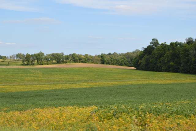
Photo: Wikimedia Commons contributor, Public domain · Wikimedia Commons
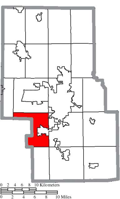
Photo: Ruhrfisch / Wikimedia Commons, CC BY-SA 3.0 · Wikimedia Commons
Local history sources: richland.ohgenweb.org · richland.ohgenweb.org · en.wikipedia.org · commons.wikimedia.org
Water
Groundwater wells (3 wells) The water here
- Mansfield City46% of residentsClear Fork Reservoir (Clear Fork of the Mohican River), plus 9 city wells
- Lexington Village41% of residentsGroundwater wells (3 wells)
- Ontario City4% of residentsGroundwater wells (3 wells)
- Walnut Hills Water Association4% of residentsGroundwater wells (3 wells)
- Cedar Creek MHP2% of residentsGroundwater wells (2 wells)
- Aqua Ohio - Mansfield System #021% of residentsGroundwater wells (3 wells)
- Lakeview Estates MHP0% of residentsGroundwater wells (2 wells)
- Eastview Community Water Association0% of residentsGroundwater wells (3 wells)
- Aqua Ohio - Mansfield System #030% of residentsGroundwater wells (1 wells)
- Aqua Ohio - Mansfield System #010% of residentsGroundwater wells (2 wells)
- Hanley Village Water Association0% of residentsGroundwater wells (2 wells)
- Peyton Community Well0% of residentsGroundwater wells (1 wells)
- M & H MHP, Llc0% of residentsGroundwater wells (1 wells)
- Madison Water District0% of residentsGroundwater wells (4 wells)
- Aqua Ohio - Mansfield System #080% of residentsGroundwater wells (1 wells)
- Hanley Acres Water Association0% of residentsGroundwater wells (2 wells)
- Willow Park Water Association0% of residentsGroundwater wells (2 wells)
- Hillside MHP0% of residentsGroundwater wells (1 wells)
- Briarwood Estates MHP0% of residentsGroundwater wells (2 wells)
Hospitals, fire stations and more
Inside Troy Township, Richland County's boundary: 1 high-hazard dam, 1 poor-rated bridge and 1 spill case. Press a pin or a name for its whole record and its source.
High-hazard dams (1)
-
Clear Fork Reservoir Dam PoorClear Fork Mohican River · condition: poor
- Hazard class
- High: a failure would probably cost a life
- Condition
- Poor (assessed 11/20/2019)
- River or stream
- Clear Fork Mohican River
- Purpose
- Water Supply;Recreation
- Type
- Earth
- Height
- 44 ft
- Storage
- 26,532 acre-feet
- Completed
- 1949
- Owner type
- Local Government
- County
- Richland County
- Nearest town (NID)
- Lexington
- Last inspection
- 11/21/2024
- Emergency action plan
- Yes
- NID ID
- OH00778
National Inventory of Dams record ↗ National Inventory of Dams (source) ↗ Street map and directions ↗
Source: U.S. Army Corps of Engineers National Inventory of Dams, August 2026. "High hazard" rates what a failure would cost downstream, not how likely one is; the condition is the state's assessment.
Bridges rated poor (1)
-
Lex-Ontario Rd over Clear Fork RiverPoor · built 1968
- Condition
- Poor: a deck, superstructure, substructure or culvert rated 4 or below on the 0 to 9 scale
- What it is
- Bridge
- Built
- 1968
- Length
- 36 ft
- Owner
- County
- Vehicles a day
- 1,481
- Coordinates
- 40.69160, -82.59356
National Bridge Inventory (source) ↗ Street map and directions ↗
Source: FHWA National Bridge Inventory 2025. "Poor" means one major part rated 4 or below on the 0 to 9 scale; it calls for repair, not closing, unless the state posts or closes the bridge.
Spills reported since 2021 (1)
-
Sheen Rainbow / Hydrocarbon Reached water2021-07-02 · Troy Twp
- Reported
- 2021-07-02
- What spilled
- Sheen Rainbow / Hydrocarbon
- Reached a waterway
- 99 - Unnamed
- Where
- Troy Twp, Richland County
- Ohio EPA district office
- NWDO
- Ohio EPA case number
- 2107EPA0000980
Ohio EPA spill reports (source) ↗ Street map and directions ↗
Source: Ohio EPA emergency response spill reports, 2021 to September 2026, one point per case where Ohio EPA placed it. A report is what the caller or responder recorded; amounts are often blank or estimated.
Its ZIP codes
Each ZIP code that touches Troy Township, Richland County, with the share of its residents who live here and the same headline figures as the ZIP page.
| ZIP | Share | Water | Radon | Home value | Schools | Flood |
|---|---|---|---|---|---|---|
| 44904 Lexington and Mansfield | 13% | Groundwater wells (3 wells) | 5.2 pCi/L average radon | Median year built 1973 | Lexington Local · 4 stars overall | 2.3% of residents in the 1% floodplain |
| 44903 Mansfield | 2% | Mostly private wells | 4.5 pCi/L average radon | Median year built 1957 | Mansfield City · 3 stars overall | 2.1% of residents in the 1% floodplain |
| 44906 Mansfield | 1% | Clear Fork Reservoir, a 4.5-billion-gallon impoundment of the Clear Fork southwest of the treatment plant, supplemented by 9 city groundwater wells | 3.9 pCi/L average radon | Median year built 1958 | Mansfield City · 3 stars overall | 0.0% of residents in the 1% floodplain |
The county
Richland County: 12 ZIP codes, 27 cities, villages and townships, 124,341 people.
Nearby places
Quick answers
What county is Troy Township, Ohio in?
Troy Township, Richland County is a township in Richland County, Ohio, with 2,551 residents.
When was Troy Township, Ohio founded?
Troy Township, Richland County was settled 1811; incorporated 1814. Founders on record: organized September 5, 1814. Source
What ZIP code is Troy Township, Ohio?
Troy Township, Richland County is served by ZIP codes 44904 and 44903; 44904 holds the largest share of its residents.
Where does Troy Township, Ohio get its water?
The main water source for Troy Township, Richland County (Mansfield City): Groundwater wells (3 wells).
Cite this page
Cite this page as:
Cracked Buckeye, "Troy Township, Richland County", https://crackedbuckeye.com/place/troy-township-richland-county/, built 2026-10-31, accessed [date].
How to cite · Report a correction · Built 2026-10-31
