Local events in Lexington
52 events in the next 90 days from 2 public calendars. All local events in Lexington
Checked October 20; the events page is refreshed daily.
How Lexington began
Lexington was laid out in 1812 by land speculator Amariah Watson Jr. on the northwest quarter of section 24 of Troy Township, on the Clear Fork of the Mohican River, and named for Lexington, Massachusetts in honor of his father's Revolutionary War service. Watson's 1813 water-powered sawmill and the settlers it drew gave the town its start; it became an official village in 1839. The railroad reached Lexington in 1850, and by the mid-20th century the village's population exploded as Mansfield's suburbs spread south and west, growing from 1,311 residents in 1960 to 2,972 in 1970 and 4,848 by 2020. Today it is a Mansfield-area suburb built around its historic 1846 Congregational church and 1850s schoolhouse.
Settled 1812, platted 1812, incorporated 1839, by Amariah Watson Jr..
Where the name comes from
Watson named the settlement for Lexington, Massachusetts, site of the first bloodshed of the Revolutionary War, out of respect for his father, a Revolutionary War veteran.
Before the town
No mound, earthwork, or named village specific to the Lexington town site is recorded in the sources reviewed. The county's nineteenth-century historians describe Troy Township generally as favored hunting ground used by Native people and, later, by the earliest pioneers, and secondary sources note that Delaware and Wyandot people were present in the wider area before Watson's 1812 arrival, but no site-specific village, trail, or burial ground within the platted village has been documented. The county-wide record includes Greentown (Delaware, with a Mingo contingent) on the Black Fork southeast of Mansfield, and the broader Wyandot/Delaware/Shawnee presence and 1817-1818 treaty cessions that cleared the region for settlement.
Nations recorded here: Wyandot, Lenape (Delaware), Mingo.
Timeline
- — Amariah Watson Jr. lays out Lexington on his land in Troy Township and builds the first cabin on the site.
- — Watson builds a water-powered sawmill on the Clear Fork of the Mohican River, drawing settlers to the new town.
- — Cook's Tavern, the village's first tavern, opens.
- — Lexington is recognized as an official village.
- — The First Congregational Church, now on the National Register, is built at 47 Delaware Street.
- — A railroad reaches Lexington, spurring business growth; by 1853 more than 50 businesses operated in the village.
- — The First Congregational Church and the c. 1850 Lexington School building are jointly listed on the National Register of Historic Places (ref. 79001929); the school later becomes the Richland County Museum.
- — Population jumps from 1,311 to 2,972, about 127 percent, as Mansfield-area suburban growth reaches the village.
Stories
A sawmill and a name from Massachusetts
Amariah Watson Jr. was a land speculator who had bought up tracts around the Clear Fork before he ever built on them. In 1812 he laid out a town on the northwest quarter of section 24 and put up the first cabin himself, with port-holes cut blockhouse-fashion for defense, since the War of 1812 was underway and the frontier still felt unsettled. He named the place Lexington in honor of his father, a Revolutionary War veteran, choosing the Massachusetts town where the war's first shots were fired. The following year Watson built a water-powered sawmill on the Clear Fork, and the promise of cut lumber and milled grain pulled in settlers such as Elisha Robins, William Gass, Calvin Culver, and Frances Mitchell. A second cabin, built by Jacob Cook, also had defensive port-holes. The town grew slowly around the mill for its first decades before the railroad arrived at mid-century and turned it into a genuine commercial center.
From country town to Mansfield suburb
For nearly a century and a half Lexington stayed what one 1903 county historian called 'a country town for the convenience of country people,' with barely 500 residents as late as 1870. That changed abruptly after World War II. As Mansfield's population and industry spread outward, Lexington's population nearly doubled between 1950 and 1960, then leapt again by 127 percent in the 1960s, from 1,311 to 2,972 residents. Growth continued into the twenty-first century, reaching 4,848 by the 2020 census. The village's historic core, anchored by the 1846 Congregational church and the schoolhouse that is now the Richland County Museum, sits today alongside subdivisions built for Mansfield commuters.
Photographs
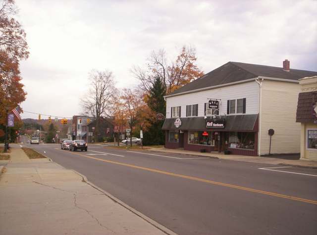
Photo: Wikimedia Commons contributor, Public domain · Wikimedia Commons
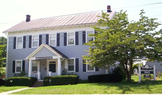
Photo: Wikimedia Commons contributor, CC0 · Wikimedia Commons
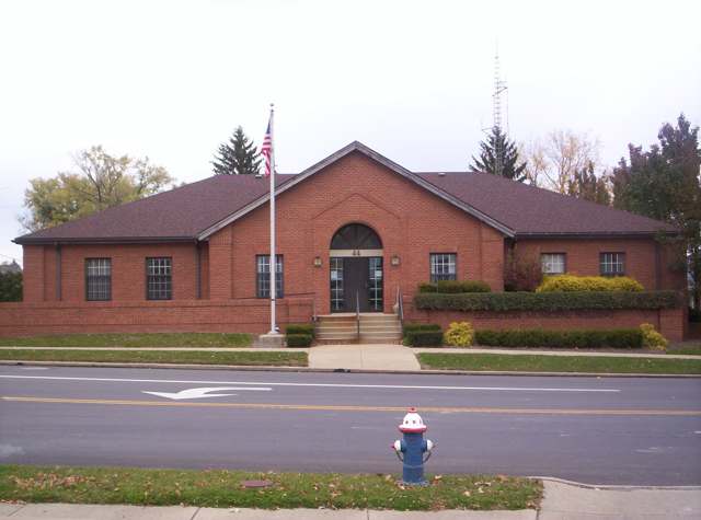
Photo: Wikimedia Commons contributor, Public domain · Wikimedia Commons
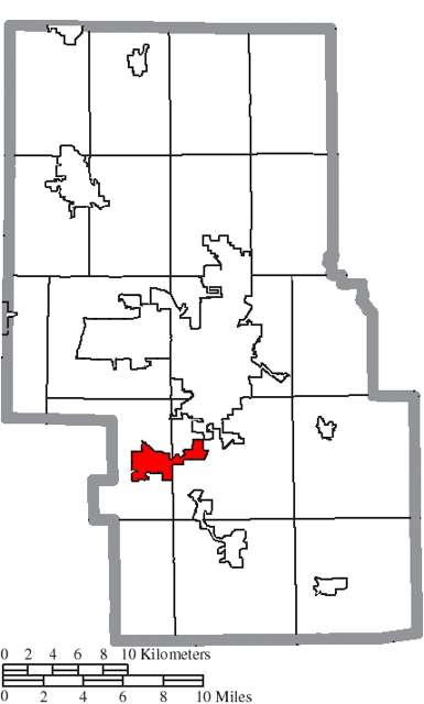
Photo: Ruhrfisch / Wikimedia Commons, CC BY-SA 3.0 · Wikimedia Commons
Local history sources: richland.ohgenweb.org · en.wikipedia.org · richland.ohgenweb.org · en.wikipedia.org · commons.wikimedia.org
Historic places
1 place in Lexington on the National Register of Historic Places. Press a pin or a name for its whole record.
-
First Congregational Church And Lexington SchoolBuilding · Lexington · listed 1979
- Address
- 47 Delaware St. and 51 W. Church St.
- Where
- Lexington, Richland County · ZIP 44904
- What it is
- Building
- Listed on the National Register
- 1979
- NRIS reference number
- 79001929
- Coordinates
- 40.67751, -82.58566
National Register file (NPS) ↗ Search Wikipedia ↗ Street map and directions ↗ On the Cracked Buckeye map
Source: National Park Service, National Register of Historic Places point file. The listing year is shown where NPS's certification date agrees with the listing's reference number. Listing recognizes significance; it does not restrict a private owner.
Water
Groundwater wells (3 wells) The water here
- Lexington Village54% of residentsGroundwater wells (3 wells)
- Mansfield City38% of residentsClear Fork Reservoir (Clear Fork of the Mohican River), plus 9 city wells
- Walnut Hills Water Association5% of residentsGroundwater wells (3 wells)
- Cedar Creek MHP2% of residentsGroundwater wells (2 wells)
- Hanley Village Water Association0% of residentsGroundwater wells (2 wells)
- M & H MHP, Llc0% of residentsGroundwater wells (1 wells)
Hospitals, fire stations and more
Inside Lexington's boundary: 1 nursing home, 1 fire or EMS station, 5 public schools, 1 library, 1 museum, 1 police station, 6 Toxics Release Inventory facilities and 3 spill cases. Press a pin or a name for its whole record and its source.
Nursing homes (1)
-
Lexington Court Care Center4 of 5 stars · Lexington
- Address
- 250 Delaware St, Lexington, OH 44904
- Certified beds
- 75
- Residents on an average day
- 71
- Medicare overall rating
- 4 of 5 stars
- Health inspections
- 3 of 5 stars
- Staffing
- 3 of 5 stars
- Quality measures
- 5 of 5 stars
- Penalties since 2023
- none
- Ownership
- For profit - Corporation
- Chain
- ATRIUM CENTERS
- Takes
- Medicare and Medicaid
- Phone
- (419) 884-2000
- Medicare ID
- 366013
Medicare Care Compare ↗ CMS nursing home data (source) ↗ Street map and directions ↗
Source: CMS Care Compare nursing home provider and penalties files; Medicare star ratings run 1 to 5.
Fire and EMS stations (1)
-
Troy Township Fire DepartmentLexington
- Address
- 199 West Main Street, Lexington, OH 44904
- Coordinates
- 40.67907, -82.58991
USGS National Map structures (source) ↗ Street map and directions ↗
Source: USGS National Map structures (most Ohio records last updated 2019 to 2022), checked against the Columbus and Cleveland station lists. The department that answers a call is set by jurisdiction and mutual aid, not by distance.
Public schools (5)
-
Central Elementary School5 of 5 stars · Lexington
- Address
- 124 Frederick St, Lexington, OH 44904
- School district
- Lexington Local School District
- Kind (NCES)
- Regular School
- Students, 2023-24
- 354
- Teachers (full-time equivalent)
- 21.95
- Report card, 2025-26
- 5 of 5 stars
- Performance index
- 90.1%
- Ohio building IRN
- 005496
- NCES school ID
- 390494303587
NCES school record ↗ Ohio School Report Card ↗ Street map and directions ↗
-
Eastern Elementary School5 of 5 stars · Lexington
- Address
- 155 Castor Rd, Lexington, OH 44904
- School district
- Lexington Local School District
- Kind (NCES)
- Regular School
- Students, 2023-24
- 512
- Teachers (full-time equivalent)
- 32.9
- Report card, 2025-26
- 5 of 5 stars
- Performance index
- 89.9%
- Ohio building IRN
- 064626
- NCES school ID
- 390494303588
NCES school record ↗ Ohio School Report Card ↗ Street map and directions ↗
-
Lexington High School4.5 of 5 stars · Lexington
- Address
- 103 Clever Ln, Lexington, OH 44904
- School district
- Lexington Local School District
- Kind (NCES)
- Regular School
- Students, 2023-24
- 679
- Teachers (full-time equivalent)
- 38.57
- Report card, 2025-26
- 4.5 of 5 stars
- Performance index
- 85.3%
- Four-year graduation rate
- 98.9%
- Ohio building IRN
- 020255
- NCES school ID
- 390494303589
NCES school record ↗ Ohio School Report Card ↗ Street map and directions ↗
-
Lexington Junior High School3 of 5 stars · Lexington
- Address
- 103 Clever Ln, Lexington, OH 44904
- School district
- Lexington Local School District
- Kind (NCES)
- Regular School
- Students, 2023-24
- 383
- Teachers (full-time equivalent)
- 23.24
- Report card, 2025-26
- 3 of 5 stars
- Performance index
- 82%
- Ohio building IRN
- 062372
- NCES school ID
- 390494303590
NCES school record ↗ Ohio School Report Card ↗ Street map and directions ↗
-
Western Elementary School5 of 5 stars · Lexington
- Address
- 385 W Main St, Lexington, OH 44904
- School district
- Lexington Local School District
- Kind (NCES)
- Regular School
- Students, 2023-24
- 323
- Teachers (full-time equivalent)
- 22.95
- Report card, 2025-26
- 5 of 5 stars
- Ohio building IRN
- 040659
- NCES school ID
- 390494303591
NCES school record ↗ Ohio School Report Card ↗ Street map and directions ↗
Source: NCES EDGE public school locations 2024-25 and Common Core of Data 2023-24 (type, students, teachers); Ohio School Report Cards 2025-26 (Department of Education and Workforce), matched by name within the district.
Public libraries (1)
-
Lexington Branch LibraryBranch · Lexington
- Address
- 25 Lutz Ave, Lexington, OH 44904
- What it is
- Branch
- Library system
- Mansfield-Richland County Public Library
- Open
- 2,964 hours a year, 52 weeks
- Building
- 6,055 sq ft
- System's visits, FY2024
- 514,540
- System's loans, FY2024
- 1,567,119
- People the system serves
- 99,110
- Phone
- (419) 884-2500
IMLS Public Libraries Survey (source) ↗ Street map and directions ↗
Source: IMLS Public Libraries Survey FY2024 (outlets and their systems). Any Ohio resident can get a free card at any Ohio public library.
Museums, historical societies, gardens and zoos (1)
-
Richland County Museum AssociationHistory museum · Lexington
- What it is
- History museum
- City
- Lexington
- Coordinates
- 40.67784, -82.58521
Search Wikipedia ↗ IMLS Museum Data Files (source) ↗ Street map and directions ↗
The museum list is IMLS's 2018 file; a museum may have closed or moved since.
Source: IMLS Museum Data Files, 2018.
Police stations (1)
-
Lexington Police DepartmentLexington
- Address
- 44 West Main Street, Lexington, OH 44904
- Coordinates
- 40.67898, -82.58417
USGS National Map structures (source) ↗ Street map and directions ↗
Source: USGS National Map structures, police stations, corrected and completed by hand (September 2026). The department that answers a call is set by jurisdiction, not by distance.
Facilities reporting toxic releases (6)
-
Charter Next GenerationToxics Release Inventory · Lexington
- Address
- 230 Industrial Drive, Lexington, OH 44904
- County
- Richland County
- Status
- Reports to the Toxics Release Inventory (***unchanged***)
- EPA program ID
- 4490WCHRTR23IND
- EPA registry ID
- 110058177002
EPA facility record ↗ EPA Facility Registry Service (source) ↗ Street map and directions ↗
-
Hamilton Standard ControlsToxics Release Inventory · Lexington
- Address
- 147 Plymouth Street, Lexington, OH 44904
- County
- Richland County
- Status
- Reports to the Toxics Release Inventory (active)
- EPA program ID
- 44904HMLTN147PL
- EPA registry ID
- 110002112614
EPA facility record ↗ EPA Facility Registry Service (source) ↗ Street map and directions ↗
-
Neer Mfg CoToxics Release Inventory · Lexington
- Address
- 265 Mill St., Lexington, OH 44904
- County
- Richland County
- Status
- Reports to the Toxics Release Inventory (closed)
- EPA program ID
- 44904NRMNF265MI
- EPA registry ID
- 110000391987
EPA facility record ↗ EPA Facility Registry Service (source) ↗ Street map and directions ↗
-
Stoneridge Inc Hi-Stat DivToxics Release Inventory · Lexington
- Address
- 345 South Mill Street, Lexington, OH 44904
- County
- Richland County
- Status
- Reports to the Toxics Release Inventory (open)
- EPA program ID
- 44904HSTTM345SO
- EPA registry ID
- 110000823805
EPA facility record ↗ EPA Facility Registry Service (source) ↗ Street map and directions ↗
-
Stoneridge, Inc.Toxics Release Inventory · Lexington
- Address
- 345 South Mill Street, Lexington, OH 44904
- County
- Richland County County
- Status
- Reports to the Toxics Release Inventory (***unchanged***)
- EPA program ID
- 4490WSTNRD345SU
- EPA registry ID
- 110064845379
EPA facility record ↗ EPA Facility Registry Service (source) ↗ Street map and directions ↗
-
Swagelok Machining Services LlcToxics Release Inventory · Lexington
- Address
- 145 Industrial Dr., Lexington, OH 44904
- County
- Richland County
- Status
- Reports to the Toxics Release Inventory (open)
- EPA program ID
- 44904MNSFL145IN
- EPA registry ID
- 110000391978
EPA facility record ↗ EPA Facility Registry Service (source) ↗ Street map and directions ↗
Source: EPA Facility Registry Service, Toxics Release Inventory reporters. Reporting a release is required of large users of listed chemicals; it is not by itself a violation.
Spills reported since 2021 (3)
-
Material Blue2025-05-21 · Lexington
- Reported
- 2025-05-21
- What spilled
- Material Blue
- Where
- Lexington, Richland County
- Ohio EPA district office
- NWDO
- Ohio EPA case number
- 2505EPA0000812
Ohio EPA spill reports (source) ↗ Street map and directions ↗
-
Freon2021-02-15 · Lexington
- Reported
- 2021-02-15
- What spilled
- Freon
- Where
- Lexington, Richland County
- Ohio EPA district office
- NWDO
- Ohio EPA case number
- 2102EPA0000204
Ohio EPA spill reports (source) ↗ Street map and directions ↗
-
Material Blue2026-04-28 · Lexington
- Reported
- 2026-04-28
- What spilled
- Material Blue
- Where
- Lexington, Richland County
- Ohio EPA district office
- NWDO
- Ohio EPA case number
- 2604EPA0000710
Ohio EPA spill reports (source) ↗ Street map and directions ↗
Source: Ohio EPA emergency response spill reports, 2021 to September 2026, one point per case where Ohio EPA placed it. A report is what the caller or responder recorded; amounts are often blank or estimated.
Its ZIP codes
Each ZIP code that touches Lexington, with the share of its residents who live here and the same headline figures as the ZIP page.
| ZIP | Share | Water | Radon | Home value | Schools | Flood |
|---|---|---|---|---|---|---|
| 44904 Lexington and Mansfield | 34% | Groundwater wells (3 wells) | 5.2 pCi/L average radon | Median year built 1973 | Lexington Local · 4 stars overall | 2.3% of residents in the 1% floodplain |
Local government
Who holds office in Lexington, how its elections and ballot issues came out, and the state auditor's record.
Ballot issues
| Date | Issue | For | Against | Result |
|---|---|---|---|---|
| 2015-11-03 | Issue: Village of Lexington - Electric Aggregation | 864 | 557 | Passed (60.8% for) |
| 2015-11-03 | Issue: Village of Lexington - Gas Aggregation | 868 | 563 | Passed (60.66% for) |
Elections for office
| Date | Office | Candidates and votes |
|---|---|---|
| 2015-11-03 | Member of Council (number of seats not on file, so winners are not marked) | Bob Jarvis 897, 37.2%; Erin Rue Underwood 767, 31.81%; Wynn H. Kearns 747, 30.98% |
| 2015-11-03 | Mayor | Eugene R. Parkison 1,307, 100.0% |
Winners in bold. Results from the county board of elections' official canvass unless marked.
Auditor of State record
- No fiscal caution, watch or emergency on the Auditor of State's lists.
- Financial Audit, 2023 to 2024, released 2026-02-12
The county
Richland County: 12 ZIP codes, 27 cities, villages and townships, 124,341 people.
Nearby places
Rain and snow
How much has actually fallen on Lexington, day by day, from 1892 to now. Daily totals, not averages.
- rain, last 30 days
- 1.48 in
- 2026-10-01 to 2026-10-30
- rain so far in 2026
- 49.3 in
- 11.5 in above normal for the date
- snow so far in 2026
- 33.2 in
- a normal year brings 35.7 in
- a normal year
- 44.6 in
- average of 30 years, 1991-2020
| Month | Rain (in) | Snow (in) | Days counted |
|---|---|---|---|
| October 2026 | 1.48 | — | 30 |
| September 2026 | 5.04 | — | 30 |
| August 2026 | 8.90 | — | 31 |
| July 2026 | 3.85 | — | 31 |
| June 2026 | 3.99 | — | 30 |
| May 2026 | 8.00 | — | 31 |
| April 2026 | 9.01 | — | 30 |
| March 2026 | 4.78 | 2.2 | 31 |
| February 2026 | 1.52 | 7.0 | 28 |
| January 2026 | 2.72 | 23.9 | 31 |
| December 2025 | 3.60 | 14.8 | 31 |
| November 2025 | 1.99 | 2.9 | 30 |
| Wettest year | 2011 — 59.7 in |
|---|---|
| Driest year | 1963 — 24.3 in |
| Snowiest year | 1893 — 86.5 in |
| Wettest day on record | 21 August 2007 — 4.62 in |
| Heaviest snowfall in a day | 20 January 2019 — 12.99 in |
| Deepest snow on the ground | 9 January 1905 — 25.00 in |
Mostly estimated. Only 11% of these days come from a gauge standing inside Lexington - the rest are worked out from the nearest gauges around it, so read them as close estimates rather than readings.
48,749 days of records, 1892-12-01 to 2026-10-30. Source: NOAA NCEI GHCN-Daily, 3,240 gauges in and around Ohio. A day is "gauged" when a gauge standing inside the boundary reported it, and the value is the mean of those gauges. Otherwise it is interpolated by inverse distance from every gauge reporting within 50 miles. Nothing is carried forward, back-filled or smoothed. Against NOAA nClimDiv county monthly precipitation over 136,848 complete county-months (checked 2026-11-01): correlation 0.9515, median absolute difference 0.217 in a month. Built 2026-11-01 from the Cracked Buckeye precipitation archive. Snow is the softer number — snowfall is measured by hand with a ruler, no agency publishes a gridded county snowfall series, and blowing snow defeats every observer.
Environmental permits and filings
What Ohio EPA has on file for Lexington: permits, inspections, violations, cleanups and the state loans behind sewer and water work. Every line links to the agency's own document.
- facilities and sites on file
- 17
- those placed on the map inside Lexington
| Program | Facilities and sites |
|---|---|
| Hazardous waste | 5 |
| Contaminated-site cleanup | 3 |
| Wastewater and stormwater discharge | 3 |
| Air pollution | 2 |
| Underground injection wells | 2 |
| Public drinking water | 1 |
| Voluntary cleanup | 1 |
| Date | Facility or site | What |
|---|---|---|
| VILLAGE OF LEXINGTON | Wastewater and stormwater discharge notice of violation | |
| LEXINGTON VILLAGE PWS | Public drinking water compliance letter | |
| VILLAGE OF LEXINGTON | Wastewater and stormwater discharge report | |
| LEXINGTON VILLAGE PWS | Public drinking water warning letter | |
| LEXINGTON PK-6 SCHOOL | Wastewater and stormwater discharge permit | |
| CONTAINERCRAFT INC | Contaminated-site cleanup cleanup response | |
| LEXINGTON VILLAGE PWS | Public drinking water report | |
| CONTAINERCRAFT INC | Contaminated-site cleanup covenant | |
| LEXINGTON PK-6 SCHOOL | Wastewater and stormwater discharge permit | |
| LEXINGTON VILLAGE PWS | Public drinking water violation resolved | |
| LEXINGTON VILLAGE PWS | Public drinking water inspection | |
| LEXINGTON VILLAGE PWS | Public drinking water notice of violation | |
| LEXINGTON VILLAGE PWS | Public drinking water compliance letter | |
| LEXINGTON VILLAGE PWS | Public drinking water inspection | |
| LEXINGTON VILLAGE PWS | Public drinking water notice of violation | |
| LEXINGTON VILLAGE PWS | Public drinking water plan | |
| LEXINGTON VILLAGE PWS | Public drinking water inspection | |
| LEXINGTON VILLAGE PWS | Public drinking water notice of violation | |
| LEXINGTON VILLAGE PWS | Public drinking water warning letter | |
| LEXINGTON VILLAGE PWS | Public drinking water inspection | |
| LEXINGTON VILLAGE PWS | Public drinking water inspection | |
| LEXINGTON VILLAGE PWS | Public drinking water notice of violation | |
| LEXINGTON VILLAGE PWS | Public drinking water notice of violation | |
| LEXINGTON VILLAGE PWS | Public drinking water compliance letter | |
| CONTAINERCRAFT INC | Contaminated-site cleanup cleanup response |
Source: Ohio EPA eDocument portal (edocpub.epa.ohio.gov), indexed 2026-10-14. Facilities are placed on the map from Ohio EPA's own map layers, EPA's Facility Registry, coordinates written in the filings, or a geocoded street address. A permit filed under a private person's name (most are household septic systems) is counted but never named, placed or linked; licenses for individual workers and open-burning notices are left out entirely.
Quick answers
What county is Lexington, Ohio in?
Lexington is a village in Richland County, Ohio, with 4,848 residents.
When was Lexington, Ohio founded?
Lexington was settled 1812; laid out 1812; incorporated 1839. Founders on record: Amariah Watson Jr. Source
How did Lexington, Ohio get its name?
Watson named the settlement for Lexington, Massachusetts, site of the first bloodshed of the Revolutionary War, out of respect for his father, a Revolutionary War veteran. Source
What ZIP code is Lexington, Ohio?
Most of Lexington is in ZIP code 44904.
Where does Lexington, Ohio get its water?
The main water source for Lexington (Lexington Village): Groundwater wells (3 wells).
Cite this page
Cite this page as:
Cracked Buckeye, "Lexington, Richland County", https://crackedbuckeye.com/place/lexington/, built 2026-10-31, accessed [date].
How to cite · Report a correction · Built 2026-10-31