Local events in Steubenville
16 events in the next 90 days from 2 public calendars. All local events in Steubenville
Checked October 20; the events page is refreshed daily.
Lakes near Steubenville
The history under the water: the valley before, the dam, the stories. All Ohio lakes
Notable people from Steubenville
Ohioans tied to this place, each with a sourced profile. All notable Ohioans
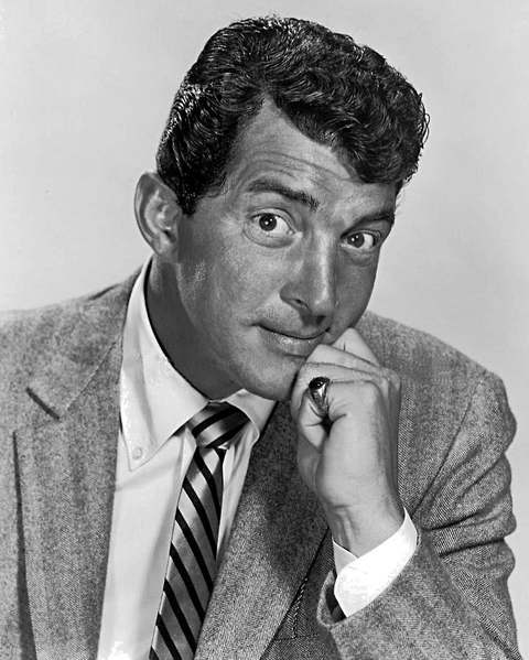 Dean Martin1917-1995Steubenville-born crooner, comic partner of Jerry Lewis, Rat Pack member and tel...
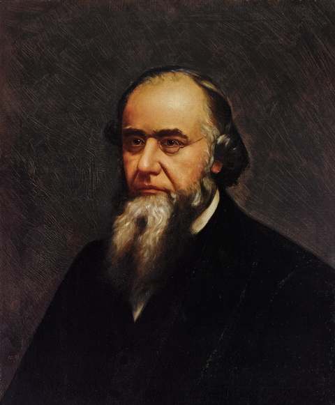 Edwin Stanton1814-1869Steubenville lawyer who became Lincoln's Secretary of War from 1862 to 1868 and ...
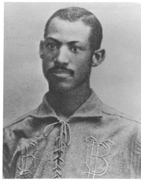 Moses Fleetwood Walker1856-1924Steubenville-raised Oberlin student who caught for the 1884 Toledo Blue Stocking...
How Steubenville began
Steubenville grew up around Fort Steuben, a log stockade the U.S. Army built in 1786-87 on the Ohio River to protect the government surveyors laying out the Seven Ranges, the first organized land survey in the Northwest Territory. When the fort burned in 1790 the settlers who had gathered around it stayed on, and on July 29, 1797 Governor Arthur St. Clair organized Jefferson County with the town, platted that year by Bezaliel Wells and James Ross, as its seat. Nineteenth-century Steubenville grew into a river port and then an industrial city on coal, iron, steel and pottery -- the Steubenville Pottery Company, organized by twenty-five local citizens in 1879, later became nationally known for its Russel Wright-designed American Modern dinnerware. The city's population peaked at 37,651 in 1940 and has declined for decades since, alongside the broader contraction of Ohio Valley steel and pottery manufacturing; it remains the Jefferson County seat and birthplace of Lincoln's Secretary of War Edwin Stanton and entertainer Dean Martin.
Settled 1786-87 (settlers gather around Fort Steuben), platted 1797, incorporated 1797 (county seat); city charter 1851, by Bezaliel Wells and James Ross.
Where the name comes from
Named for Fort Steuben, the 1786-87 army stockade on the site, itself named for Baron Friedrich Wilhelm von Steuben, the Prussian-born officer who drilled and reformed the Continental Army at Valley Forge under George Washington.
Before the town
No source reviewed names a Native American village, mound or documented encounter within the Steubenville town plat itself; the land was already open to survey under the Treaty of Fort McIntosh (1785) and confirmed by the Treaty of Greenville (1795) by the time Wells and Ross platted the town in 1797. Fort Steuben's own founding purpose was defensive: it was built in 1786-87 specifically to protect federal land surveyors working the Seven Ranges, after earlier survey parties had been attacked and forced to withdraw in 1785, which is itself evidence that the area was still contested Native ground within living memory of the town's founding. Three miles downriver from Steubenville, within what is now the separate village of Mingo Junction, stood Mingo Town (Mingo Bottom), a documented 18th-century settlement of Seneca-Cayuga (Mingo) people that George Washington visited in 1770 and that was at times home to the Mingo leader Logan.
Nations recorded here: Mingo (Seneca-Cayuga), Wyandot, Shawnee, Lenape (Delaware).
Timeline
- — The site for Fort Steuben is selected on October 11, on high ground about 120 yards from the Ohio River, to protect government land surveyors working the newly ordered Seven Ranges survey.
- — Major John Francis Hamtramck's First American Regiment completes Fort Steuben, a square stockade with a blockhouse at each corner, named for Baron von Steuben on January 2 and finished by January 8.
- — Fort Steuben, already abandoned by the army once the survey work moved on, is destroyed by fire and never rebuilt; settlers who had gathered around it remain.
- — Governor Arthur St. Clair organizes Jefferson County by proclamation on July 29, and Bezaliel Wells and James Ross plat Steubenville on the former fort site as its county seat.
- — Edwin McMasters Stanton, later Abraham Lincoln's Secretary of War, is born in Steubenville on December 19.
- — Steubenville receives its city charter.
- — Frazier, Kilgore and Company erects a rolling mill, forerunner of the city's steel industry, and the Steubenville Coal and Mining Company sinks a coal shaft.
- — Twenty-five Steubenville citizens organize the Steubenville Pottery Company; it fires its first kiln in 1881.
- — The Carnegie Library of Steubenville, designed by the Pittsburgh firm Alden & Harlow and funded by a $50,000 pledge from Andrew Carnegie, opens March 12 as the first Carnegie-funded library in Ohio.
- — Steubenville Pottery Company introduces Russel Wright's American Modern dinnerware line, which becomes the company's best-known product nationally.
- — Steubenville's population peaks at 37,651.
- — Steubenville Pottery Company closes; Canonsburg Pottery buys its molds.
- — The U.S. Department of Justice investigates the Steubenville police department for excessive force and improper searches; the city signs a federal consent decree that runs until March 4, 2005.
Stories
A fort built to guard the surveyors, not the settlers
Fort Steuben was raised in the dead of a 1786-87 winter for a narrow, specific purpose: protecting the federal surveying parties who were laying out the Seven Ranges, the first organized land survey conducted under the 1785 Land Ordinance anywhere in the Northwest Territory. Earlier survey crews working the same ground in 1785 had been attacked and driven off, so Major John Francis Hamtramck's First American Regiment built a square stockade with a blockhouse at each corner on high ground above the Ohio River, garrisoned by his own company and Captain Mercer's. The fort did its job quickly: by May 1787 the survey parties had moved on toward Fort Harmar, the garrison evacuated, and in 1790 the abandoned structure burned. What outlasted the fort was the handful of families who had settled in its shadow, who kept the name and the site; when Bezaliel Wells and James Ross platted a permanent town there in 1797, they built it directly on the old fort ground and it took Steuben's name as its own.
From twenty-five subscribers to Russel Wright's dinnerware
In 1879, twenty-five Steubenville citizens pooled their money to organize the Steubenville Pottery Company, betting on a combination the Ohio Valley had in abundance: coal to fire the kilns, clay to throw, the Ohio River for shipping, and the Pan Handle Railroad running through town. The company fired its first kiln in 1881 and by the early 1900s was turning out semi-vitreous dinnerware, granite ware and toilet sets, adding kilns as it grew. Its lasting fame came late: in 1939 the company put designer Russel Wright's American Modern line into production, a streamlined, colorful dinnerware pattern that became one of the best-selling American ceramic lines of the twentieth century and is still collected today. The company could not outlast the industry-wide decline that emptied out the Ohio Valley's potteries after World War II, and closed in 1959; Canonsburg Pottery, just across the river in Pennsylvania, bought its molds and kept producing some of the old patterns.
Photographs
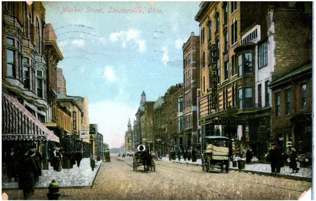
Photo: Columbus Metropolitan Library, via Digital Public Library of America / Ohio Digital Network, public domain · Wikimedia Commons
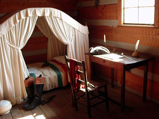
Photo: Judy Bratten / Federal Highway Administration, public domain · Wikimedia Commons
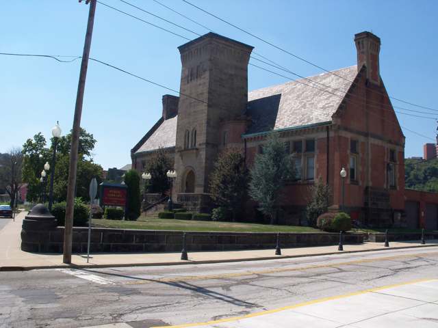
Photo: Roseohioresident, Wikimedia Commons, public domain · Wikimedia Commons
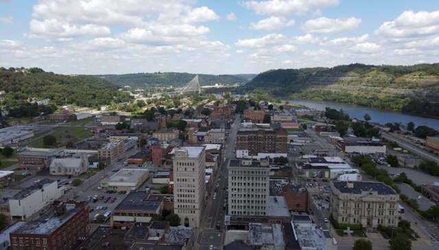
Photo: PokéTube, Wikimedia Commons, CC BY-SA 4.0 · Wikimedia Commons
Local history sources: en.wikipedia.org · en.wikipedia.org · en.wikipedia.org · en.wikipedia.org · en.wikipedia.org · heraldstaronline.com · hmdb.org · en.wikipedia.org · commons.wikimedia.org · commons.wikimedia.org · commons.wikimedia.org · commons.wikimedia.org
Historic places
5 places in Steubenville on the National Register of Historic Places. Press a pin or a name for its whole record.
-
Carnegie Library of SteubenvilleBuilding · Steubenville · listed 1992
- Address
- 407 S. Fourth St.
- Where
- Steubenville, Jefferson County · ZIP 43952
- What it is
- Building
- Listed on the National Register
- 1992
- NRIS reference number
- 92001160
- Coordinates
- 40.35524, -80.61810
National Register file (NPS) ↗ Search Wikipedia ↗ Street map and directions ↗ On the Cracked Buckeye map
-
First Methodist Episcopal--Holy Trinity Greek Orthodox ChurchBuilding · Steubenville · listed 2006
- Address
- 300 S. Fourth St.
- Where
- Steubenville, Jefferson County · ZIP 43952
- What it is
- Building
- Listed on the National Register
- 2006
- NRIS reference number
- 06000093
- Coordinates
- 40.35636, -80.61660
National Register file (NPS) ↗ Search Wikipedia ↗ Street map and directions ↗ On the Cracked Buckeye map
-
Market Street Section, Retaining Wall and Water TroughStructure · Steubenville · listed 1992
- Address
- Old Market St. between Market St. off ramp and Lawson Ave.
- Where
- Steubenville, Jefferson County · ZIP 43952
- What it is
- Structure
- Listed on the National Register
- 1992
- NRIS reference number
- 92001353
- Coordinates
- 40.36393, -80.62539
National Register file (NPS) ↗ Search Wikipedia ↗ Street map and directions ↗ On the Cracked Buckeye map
-
Ohio Valley Clay CompanyBuilding · Steubenville · listed 1979
- Address
- Washington and Water Sts.
- Where
- Steubenville, Jefferson County · ZIP 43952
- What it is
- Building
- Listed on the National Register
- 1979
- NRIS reference number
- 79001868
- Coordinates
- 40.36073, -80.61116
National Register file (NPS) ↗ Search Wikipedia ↗ Street map and directions ↗ On the Cracked Buckeye map
-
Steubenville YMCA BuildingBuilding · Steubenville · listed 1982
- Address
- 214 N. 4th St.
- Where
- Steubenville, Jefferson County · ZIP 43952
- What it is
- Building
- Listed on the National Register
- 1982
- NRIS reference number
- 82003601
- Coordinates
- 40.36218, -80.61386
National Register file (NPS) ↗ Search Wikipedia ↗ Street map and directions ↗ On the Cracked Buckeye map
Source: National Park Service, National Register of Historic Places point file. The listing year is shown where NPS's certification date agrees with the listing's reference number. Listing recognizes significance; it does not restrict a private owner.
Water
Ohio River, drawn at the Alikanna Pump Station (raw water pumping station and intakes at Ohio River mile 65.3) and pumped to the Filtration Plant on University Blvd. The water here
- Steubenville, City Of89% of residentsOhio River
- Wintersville Village6% of residentsOhio River
- Jefferson Co. W and S District- A3% of residentsGroundwater wells (3 wells)
- Jefferson Co. W and S District - M1% of residentsOhio River
- Jefferson Co. W&s District- O0% of residentsOhio River
Hospitals, fire stations and more
Inside Steubenville's boundary: 2 hospitals, 2 nursing homes, 3 fire and EMS stations, 2 colleges, 6 public schools, 3 private schools, 3 poor-rated bridges, 3 libraries, 2 museums, 2 police stations, 1 public charging site, 6 shale and injection wells, 2 Superfund sites, 1 Toxics Release Inventory facility and 12 spill cases. Press a pin or a name for its whole record and its source.
Hospitals (2)
-
Trinity Medical Center EastSpecialty hospital · Steubenville
- What it is
- Specialty hospital
- Address
- 380 Summit Avenue, Steubenville, OH 43952
- County
- Jefferson County
- Beds
- 82
- Ownership
- Non-profit
- Phone
- (740) 264-8581
Where HIFLD got this record ↗ HIFLD hospitals (source) ↗ Street map and directions ↗
-
Trinity Medical Center WestGeneral hospital · Steubenville
- What it is
- General hospital
- Address
- 4000 Johnson Road, Steubenville, OH 43952
- County
- Jefferson County
- Beds
- 248
- Helipad
- Yes
- Ownership
- Non-profit
- Medicare overall rating
- 2 of 5 stars
- Emergency department (Medicare)
- Yes
- Medicare reports it as
- Trinity Medical Ctr East &Trinity Medical Ctr West
- Phone
- (740) 264-8581
- Medicare ID
- 360211
Medicare Care Compare ↗ Where HIFLD got this record ↗ HIFLD hospitals (source) ↗ Street map and directions ↗
Source: HIFLD hospitals inventory via FEMA (closed hospitals it still lists left out, hospitals opened since added), with Medicare Care Compare ratings matched by name and address.
Nursing homes (2)
-
Carriage Inn of Steubenville4 of 5 stars · Steubenville
- Address
- 3102 St Charles Drive, Steubenville, OH 43952
- Certified beds
- 120
- Residents on an average day
- 99
- Medicare overall rating
- 4 of 5 stars
- Health inspections
- 3 of 5 stars
- Staffing
- 3 of 5 stars
- Quality measures
- 5 of 5 stars
- Penalties since 2023
- none
- Ownership
- For profit - Limited Liability company
- Takes
- Medicare and Medicaid
- Phone
- (740) 264-7161
- Medicare ID
- 365271
Medicare Care Compare ↗ CMS nursing home data (source) ↗ Street map and directions ↗
-
Laurels of Steubenville The2 of 5 stars · Steubenville
- Address
- 500 Stanton Boulevard, Steubenville, OH 43952
- Certified beds
- 98
- Residents on an average day
- 85
- Medicare overall rating
- 2 of 5 stars
- Health inspections
- 2 of 5 stars
- Staffing
- 3 of 5 stars
- Quality measures
- 4 of 5 stars
- Penalties since 2023
- none
- Ownership
- For profit - Corporation
- Chain
- CIENA HEALTHCARE/LAUREL HEALTH CARE
- Takes
- Medicare and Medicaid
- Phone
- (740) 264-5042
- Medicare ID
- 366363
Medicare Care Compare ↗ CMS nursing home data (source) ↗ Street map and directions ↗
Source: CMS Care Compare nursing home provider and penalties files; Medicare star ratings run 1 to 5.
Fire and EMS stations (3)
-
Steubenville Fire Department Headquarters StationSteubenville
- Address
- 417 North Street, Steubenville, OH 43952
- Coordinates
- 40.36377, -80.61397
USGS National Map structures (source) ↗ Street map and directions ↗
-
Steubenville Fire Department Pleasant Heights Station 3Steubenville
- Address
- 1332 West Adams Street, Steubenville, OH 43952
- Coordinates
- 40.35981, -80.62871
USGS National Map structures (source) ↗ Street map and directions ↗
-
Steubenville Fire Department West End Station 5Steubenville
- Address
- 3900 Sunset Boulevard, Steubenville, OH 43952
- Coordinates
- 40.37728, -80.66842
USGS National Map structures (source) ↗ Street map and directions ↗
Source: USGS National Map structures (most Ohio records last updated 2019 to 2022), checked against the Columbus and Cleveland station lists. The department that answers a call is set by jurisdiction and mutual aid, not by distance.
Colleges (2)
-
Franciscan University of SteubenvillePrivate nonprofit college · Steubenville
- What it is
- Private nonprofit college
- City
- Steubenville
- Students, 2023-24 (12-month count)
- 4,552
- Tuition and fees, in state
- $32,630
- Graduation rate
- 79% of bachelor's students, within six years (a class of 428)
- IPEDS unit ID
- 205957
College Navigator (NCES) ↗ IPEDS data (source) ↗ Street map and directions ↗
-
Trinity Health System School of NursingPrivate nonprofit two-year college · Steubenville
- What it is
- Private nonprofit two-year college
- City
- Steubenville
- Students, 2023-24 (12-month count)
- 45
- Tuition and fees, in state
- $9,149
- Tuition and fees, out of state
- $9,157
- Graduation rate
- 25% within three years (a class of 4)
- IPEDS unit ID
- 204893
College Navigator (NCES) ↗ IPEDS data (source) ↗ Street map and directions ↗
Source: NCES IPEDS 2024 directory, 2023-24 enrollment and tuition, graduation rates for the 2017 (four-year) and 2020 (two-year) entering classes.
Public schools (6)
-
East Garfield Elementary School4 of 5 stars · Steubenville
- Address
- 936 N 5th St, Steubenville, OH 43952
- School district
- Steubenville City School District
- Kind (NCES)
- Regular School
- Students, 2023-24
- 353
- Teachers (full-time equivalent)
- 21
- Report card, 2025-26
- 4 of 5 stars
- Performance index
- 93.6%
- Ohio building IRN
- 032433
- NCES school ID
- 390448201710
NCES school record ↗ Ohio School Report Card ↗ Street map and directions ↗
-
Harding Middle School4 of 5 stars · Steubenville
- Address
- 2002 Sunset Blvd, Steubenville, OH 43952
- School district
- Steubenville City School District
- Kind (NCES)
- Regular School
- Students, 2023-24
- 785
- Teachers (full-time equivalent)
- 46
- Report card, 2025-26
- 4 of 5 stars
- Performance index
- 94.4%
- Ohio building IRN
- 015180
- NCES school ID
- 390448201707
NCES school record ↗ Ohio School Report Card ↗ Street map and directions ↗
-
McKinley STEM Academy4.5 of 5 stars · Steubenville
- Address
- 1400 Adams St, Steubenville, OH 43952
- School district
- Steubenville City School District
- Kind (NCES)
- Regular School
- Students, 2023-24
- 176
- Teachers (full-time equivalent)
- 11
- Report card, 2025-26
- 4.5 of 5 stars
- Performance index
- 98.6%
- Ohio building IRN
- 017520
- NCES school ID
- 390448206011
NCES school record ↗ Ohio School Report Card ↗ Street map and directions ↗
-
Pugliese Elementary West5 of 5 stars · Steubenville
- Address
- 435 John Scott Hwy Connector, Steubenville, OH 43952
- School district
- Steubenville City School District
- Kind (NCES)
- Regular School
- Students, 2023-24
- 473
- Teachers (full-time equivalent)
- 24
- Report card, 2025-26
- 5 of 5 stars
- Performance index
- 99.3%
- Ohio building IRN
- 004200
- NCES school ID
- 390448201704
NCES school record ↗ Ohio School Report Card ↗ Street map and directions ↗
-
Steubenville High School5 of 5 stars · Steubenville
- Address
- 420 N 4th St, Steubenville, OH 43952
- School district
- Steubenville City School District
- Kind (NCES)
- Regular School
- Students, 2023-24
- 721
- Teachers (full-time equivalent)
- 43
- Report card, 2025-26
- 5 of 5 stars
- Performance index
- 92.7%
- Four-year graduation rate
- 99.5%
- Ohio building IRN
- 036020
- NCES school ID
- 390448201711
NCES school record ↗ Ohio School Report Card ↗ Street map and directions ↗
-
Wells Academy5 of 5 stars · Steubenville
- Address
- 420 N 4th St, Steubenville, OH 43952
- School district
- Steubenville City School District
- Kind (NCES)
- Regular School
- Students, 2023-24
- 338
- Teachers (full-time equivalent)
- 16
- Report card, 2025-26
- 5 of 5 stars
- Performance index
- 104.1%
- Ohio building IRN
- 040246
- NCES school ID
- 390448204283
NCES school record ↗ Ohio School Report Card ↗ Street map and directions ↗
Source: NCES EDGE public school locations 2024-25 and Common Core of Data 2023-24 (type, students, teachers); Ohio School Report Cards 2025-26 (Department of Education and Workforce), matched by name within the district.
Private schools (3)
-
Bishop John King Mussio Central ElementaryPrivate, Catholic · Steubenville
- Address
- 100 Etta Ave, Steubenville, OH 43952
- Kind
- Catholic
- Students, 2023-24
- 282
- Teachers (full-time equivalent)
- 24.8
- Students per teacher
- 11.371
- Phone
- (740) 264-2550
- NCES private school ID
- 01060422
-
Bishop John King Mussio Central Junior High SchoolPrivate, Catholic · Steubenville
- Address
- 320 Westview Ave Ste 2, Steubenville, OH 43952
- Kind
- Catholic
- Students, 2023-24
- 177
- Teachers (full-time equivalent)
- 17
- Students per teacher
- 10.4118
- Phone
- (740) 317-4797
- NCES private school ID
- A0902561
-
Catholic Central High SchoolPrivate, Catholic · Steubenville
- Address
- 320 Westview Ave, Steubenville, OH 43952
- Kind
- Catholic
- Students, 2023-24
- 255
- Teachers (full-time equivalent)
- 20
- Students per teacher
- 12.75
- Phone
- (740) 264-5538
- NCES private school ID
- 01060433
Source: NCES Private School Survey 2023-24.
Bridges rated poor (3)
-
Market St-Wva2spur over SR-7 Rr & Ohio RiverPoor · built 1905
- Condition
- Poor: a deck, superstructure, substructure or culvert rated 4 or below on the 0 to 9 scale
- What it is
- Bridge
- Built
- 1905
- Length
- 547 ft
- Owner
- State
- Vehicles a day
- 6,845
- Coordinates
- 40.35921, -80.61249
National Bridge Inventory (source) ↗ Street map and directions ↗
-
Nb Ramp Onto SR 43 over SR 43 Under Ramp BPoor · built 1975
- Condition
- Poor: a deck, superstructure, substructure or culvert rated 4 or below on the 0 to 9 scale
- What it is
- Bridge
- Built
- 1975
- Length
- 65 ft
- Owner
- State
- Vehicles a day
- 1,000
- Coordinates
- 40.36319, -80.62267
National Bridge Inventory (source) ↗ Street map and directions ↗
-
Ramp A of SR 43 over Adam St.ramp B Ovr Rmp APoor · built 1975
- Condition
- Poor: a deck, superstructure, substructure or culvert rated 4 or below on the 0 to 9 scale
- What it is
- Bridge
- Built
- 1975
- Length
- 46 ft
- Owner
- State
- Vehicles a day
- 2,030
- Coordinates
- 40.36208, -80.62248
National Bridge Inventory (source) ↗ Street map and directions ↗
Source: FHWA National Bridge Inventory 2025. "Poor" means one major part rated 4 or below on the 0 to 9 scale; it calls for repair, not closing, unless the state posts or closes the bridge.
Public libraries (3)
-
Steubenville & Jefferson County, Pl OfCentral library · Steubenville
- Address
- 407 S. 4Th St., Steubenville, OH 43952
- What it is
- Central library
- Library system
- Steubenville & Jefferson County, Pl Of
- Open
- 3,057 hours a year, 52 weeks
- Building
- 22,000 sq ft
- System's visits, FY2024
- 130,624
- System's loans, FY2024
- 358,384
- People the system serves
- 65,249
- Phone
- (740) 282-9782
IMLS Public Libraries Survey (source) ↗ Street map and directions ↗
-
Steubenville & Jefferson County, Pl Of (Steubenville)Bookmobile stop · Steubenville
- Address
- 407 S. 4Th St., Steubenville, OH 43952
- What it is
- Bookmobile stop
- Library system
- Steubenville & Jefferson County, Pl Of
- Open
- 1,937 hours a year, 50 weeks
- System's visits, FY2024
- 130,624
- System's loans, FY2024
- 358,384
- People the system serves
- 65,249
- Phone
- (740) 282-9782
IMLS Public Libraries Survey (source) ↗ Street map and directions ↗
-
Steubenville-Schiappa Branch LibraryBranch · Steubenville
- Address
- 4141 Mall Dr., Steubenville, OH 43952
- What it is
- Branch
- Library system
- Steubenville & Jefferson County, Pl Of
- Open
- 3,265 hours a year, 52 weeks
- Building
- 24,000 sq ft
- System's visits, FY2024
- 130,624
- System's loans, FY2024
- 358,384
- People the system serves
- 65,249
- Phone
- (740) 264-6166
IMLS Public Libraries Survey (source) ↗ Street map and directions ↗
Source: IMLS Public Libraries Survey FY2024 (outlets and their systems). Any Ohio resident can get a free card at any Ohio public library.
Museums, historical societies, gardens and zoos (2)
-
Historic Fort SteubenHistorical society · Steubenville
- What it is
- Historical society
- City
- Steubenville
- Coordinates
- 40.35884, -80.61393
Search Wikipedia ↗ IMLS Museum Data Files (source) ↗ Street map and directions ↗
The museum list is IMLS's 2018 file; a museum may have closed or moved since.
-
Tony And Nina Gentile GalleryArt museum · Steubenville
- What it is
- Art museum
- City
- Steubenville
- Coordinates
- 40.37411, -80.62167
Search Wikipedia ↗ IMLS Museum Data Files (source) ↗ Street map and directions ↗
The museum list is IMLS's 2018 file; a museum may have closed or moved since.
Source: IMLS Museum Data Files, 2018.
Police stations (2)
-
Jefferson County Sheriff's OfficeSteubenville
- Address
- 16001 State Route 7, Steubenville, OH 43952
- Coordinates
- 40.36131, -80.61068
USGS National Map structures (source) ↗ Street map and directions ↗
-
Steubenville Police DepartmentSteubenville
- Address
- 115 South 3rd Street, Steubenville, OH 43952
- Coordinates
- 40.35884, -80.61447
USGS National Map structures (source) ↗ Street map and directions ↗
Source: USGS National Map structures, police stations, corrected and completed by hand (September 2026). The department that answers a call is set by jurisdiction, not by distance.
Public EV charging (1)
-
SHS STEM ACADEM STEM EV1 Level 2 · Steubenville
- Address
- 320 N. 4th St, Steubenville, OH 43952
- Ports
- 1 Level 2
- Plugs
- J1772
- Network
- ChargePoint Network
- Hours
- 24 hours daily
- Phone
- 888-758-4389
Station Locator (NREL) ↗ Alternative Fuels Data Center (source) ↗ Street map and directions ↗
Source: NREL Alternative Fuels Data Center station list (May 2026), public and open stations, the posts at one address counted as one site.
Shale and injection wells (6)
-
Giusto E Crc Jf 4HUtica shale well
- What it is
- Utica shale well
- Drilled sideways
- Yes
- Operator
- Ascent Resources Utica Llc
- County
- Jefferson County
- API well number
- 34081207170000
- Coordinates
- 40.34602, -80.67842
ODNR oil and gas wells (source) ↗ Street map and directions ↗
The point is the surface well head (the pad); a horizontal well runs a mile or more underground from it.
-
Giusto E Crc Jf 6HUtica shale well
- What it is
- Utica shale well
- Drilled sideways
- Yes
- Operator
- Ascent Resources Utica Llc
- County
- Jefferson County
- API well number
- 34081207180000
- Coordinates
- 40.34596, -80.67842
ODNR oil and gas wells (source) ↗ Street map and directions ↗
The point is the surface well head (the pad); a horizontal well runs a mile or more underground from it.
-
Giusto W Crc Jf 2HUtica shale well
- What it is
- Utica shale well
- Drilled sideways
- Yes
- Operator
- Ascent Resources Utica Llc
- County
- Jefferson County
- API well number
- 34081207160000
- Coordinates
- 40.34607, -80.67842
ODNR oil and gas wells (source) ↗ Street map and directions ↗
The point is the surface well head (the pad); a horizontal well runs a mile or more underground from it.
-
Hammack Crc Jf 4HUtica shale well
- What it is
- Utica shale well
- Drilled sideways
- Yes
- Operator
- Ascent Resources Utica Llc
- County
- Jefferson County
- API well number
- 34081208380000
- Coordinates
- 40.35105, -80.66711
ODNR oil and gas wells (source) ↗ Street map and directions ↗
The point is the surface well head (the pad); a horizontal well runs a mile or more underground from it.
-
Hammack E Crc Jf 2HUtica shale well
- What it is
- Utica shale well
- Drilled sideways
- Yes
- Operator
- Ascent Resources Utica Llc
- County
- Jefferson County
- API well number
- 34081208370000
- Coordinates
- 40.35110, -80.66714
ODNR oil and gas wells (source) ↗ Street map and directions ↗
The point is the surface well head (the pad); a horizontal well runs a mile or more underground from it.
-
Hammack W Crc Jf 8HUtica shale well
- What it is
- Utica shale well
- Drilled sideways
- Yes
- Operator
- Ascent Resources Utica Llc
- County
- Jefferson County
- API well number
- 34081207270000
- Coordinates
- 40.34591, -80.67842
ODNR oil and gas wells (source) ↗ Street map and directions ↗
The point is the surface well head (the pad); a horizontal well runs a mile or more underground from it.
Source: ODNR Division of Oil and Gas Resources well inventory (September 2026): drilled Utica, Marcellus and horizontal wells and Class II injection wells not plugged. Older vertical wells are on the full map.
Superfund sites (2)
-
Divco SiteSuperfund program · Steubenville
- Address
- 712 N Fourth St, Steubenville, OH 43952
- County
- Jefferson County
- Status
- Superfund program site, not on the National Priorities List
- EPA program ID
- OH0002333821
- EPA registry ID
- 110004728395
EPA facility record ↗ EPA Facility Registry Service (source) ↗ Street map and directions ↗
-
Weirton SteelSuperfund program · Steubenville
- Address
- 200 Slack Street, Steubenville, OH 43952
- County
- Jefferson County
- Status
- Superfund program site, not on the National Priorities List
- EPA program ID
- OHN000510555
- EPA registry ID
- 110043437527
EPA facility record ↗ EPA Facility Registry Service (source) ↗ Street map and directions ↗
Source: EPA Facility Registry Service, Superfund (SEMS) and National Priorities List sites. Many program sites were assessed and needed no cleanup.
Facilities reporting toxic releases (1)
-
Severstal Wheeling Inc.Toxics Release Inventory · Steubenville
- Address
- 440 S Third St, Steubenville, OH 43952
- County
- Jefferson County
- Status
- Reports to the Toxics Release Inventory (active)
- EPA program ID
- 43952WHLNGSOUTH
- EPA registry ID
- 110042002338
EPA facility record ↗ EPA Facility Registry Service (source) ↗ Street map and directions ↗
Source: EPA Facility Registry Service, Toxics Release Inventory reporters. Reporting a release is required of large users of listed chemicals; it is not by itself a violation.
Spills reported since 2021 (12)
-
Oil Motor / Lube Oil / Vehicle2025-10-09 · Steubenville
- Reported
- 2025-10-09
- What spilled
- Oil Motor / Lube Oil / Vehicle
- Where
- Steubenville, Jefferson County
- Ohio EPA district office
- SEDO
- Ohio EPA case number
- 2510EPA0001668
Ohio EPA spill reports (source) ↗ Street map and directions ↗
-
Waste Water Reached water2024-03-27 · Steubenville
- Reported
- 2024-03-27
- What spilled
- Waste Water
- Reached a waterway
- 41 - Wills Creek
- Where
- Steubenville, Jefferson County
- Ohio EPA district office
- SEDO
- Ohio EPA case number
- 2403EPA0000475
Ohio EPA spill reports (source) ↗ Street map and directions ↗
-
Sheen Rainbow / Hydrocarbon2024-03-08 · Steubenville
- Reported
- 2024-03-08
- What spilled
- Sheen Rainbow / Hydrocarbon; Oil Petroleum Not Otherwise Specified (Nos)
- Where
- Steubenville, Jefferson County
- Ohio EPA district office
- SEDO
- Ohio EPA case number
- 2403EPA0000374
Ohio EPA spill reports (source) ↗ Street map and directions ↗
-
Oil Petroleum Not Otherwise Specified (Nos)2024-02-02 · Steubenville
- Reported
- 2024-02-02
- What spilled
- Oil Petroleum Not Otherwise Specified (Nos)
- Where
- Steubenville, Jefferson County
- Ohio EPA district office
- SEDO
- Ohio EPA case number
- 2402EPA0000183
Ohio EPA spill reports (source) ↗ Street map and directions ↗
-
Fuel Diesel / Diesel Fuel (Vehicle On Or Off Road) Reached water2023-09-14 · Steubenville
- Reported
- 2023-09-14
- What spilled
- Fuel Diesel / Diesel Fuel (Vehicle On Or Off Road)
- Largest amount reported
- 22 gallons
- Reached a waterway
- Ohio River
- Where
- Steubenville, Jefferson County
- Ohio EPA district office
- SEDO
- Ohio EPA case number
- 2309EPA0001607
Ohio EPA spill reports (source) ↗ Street map and directions ↗
-
Other / All Other / Trade Name / Mixture / Solution Etc Reached water2023-07-19 · Steubenville
- Reported
- 2023-07-19
- What spilled
- Other / All Other / Trade Name / Mixture / Solution Etc
- Reached a waterway
- 41 - Ohio River
- Where
- Steubenville, Jefferson County
- Ohio EPA district office
- SEDO
- Ohio EPA case number
- 2307EPA0001212
Ohio EPA spill reports (source) ↗ Street map and directions ↗
-
Sewage Human2022-11-16 · Steubenville
- Reported
- 2022-11-16
- What spilled
- Sewage Human
- Where
- Steubenville, Jefferson County
- Ohio EPA district office
- SEDO
- Ohio EPA case number
- 2211EPA0001708
Ohio EPA spill reports (source) ↗ Street map and directions ↗
-
Other / All Other / Trade Name / Mixture / Solution Etc Reached water2022-11-06 · Steubenville
- Reported
- 2022-11-06
- What spilled
- Other / All Other / Trade Name / Mixture / Solution Etc
- Reached a waterway
- 41 - Ohio River
- Where
- Steubenville, Jefferson County
- Ohio EPA district office
- SEDO
- Ohio EPA case number
- 2211EPA0001651
Ohio EPA spill reports (source) ↗ Street map and directions ↗
-
Oil Hydraulic Fluid(S)2022-02-09 · Steubenville
- Reported
- 2022-02-09
- What spilled
- Oil Hydraulic Fluid(S)
- Largest amount reported
- 100 gallons
- Where
- Steubenville, Jefferson County
- Ohio EPA district office
- SEDO
- Ohio EPA case number
- 2202EPA0000154
Ohio EPA spill reports (source) ↗ Street map and directions ↗
-
Sewage Human Reached water2021-09-22 · Steubenville
- Reported
- 2021-09-22
- What spilled
- Sewage Human
- Largest amount reported
- 1,000,000 gallons
- Reached a waterway
- 41 - Ohio River
- Where
- Steubenville, Jefferson County
- Ohio EPA district office
- SEDO
- Ohio EPA case number
- 2109EPA0001506
Ohio EPA spill reports (source) ↗ Street map and directions ↗
-
Fuel Diesel / Diesel Fuel (Vehicle On Or Off Road)2021-08-27 · Steubenville
- Reported
- 2021-08-27
- What spilled
- Fuel Diesel / Diesel Fuel (Vehicle On Or Off Road)
- Largest amount reported
- 1,500 gallons
- Where
- Steubenville, Jefferson County
- Ohio EPA district office
- SEDO
- Ohio EPA case number
- 2108EPA0001350
Ohio EPA spill reports (source) ↗ Street map and directions ↗
-
Chemical(S) Unk Reached water2026-08-07 · Steubenville
- Reported
- 2026-08-07
- What spilled
- Chemical(S) Unk
- Reached a waterway
- 41 - Ohio River
- Where
- Steubenville, Jefferson County
- Ohio EPA district office
- SEDO
- Ohio EPA case number
- 2608EPA0001446
Ohio EPA spill reports (source) ↗ Street map and directions ↗
Source: Ohio EPA emergency response spill reports, 2021 to September 2026, one point per case where Ohio EPA placed it. A report is what the caller or responder recorded; amounts are often blank or estimated.
Its ZIP codes
Each ZIP code that touches Steubenville, with the share of its residents who live here and the same headline figures as the ZIP page.
| ZIP | Share | Water | Radon | Home value | Schools | Flood |
|---|---|---|---|---|---|---|
| 43952 Steubenville | 86% | Ohio River, drawn at the Alikanna Pump Station (raw water pumping station and intakes at Ohio River mile 65.3) and pumped to the Filtration Plant on University Blvd. | 6.3 pCi/L average radon | Median year built 1949 | Steubenville City · 5 stars overall | 1.1% of residents in the 1% floodplain |
| 43953 Cross Creek Township and Steubenville | 23% | Ohio River intake serving the city's water treatment plant on the riverfront in Toronto | 4.6 pCi/L average radon | Median year built 1961 | Indian Creek Local · 3.5 stars overall | 0.0% of residents in the 1% floodplain |
Local government
Who holds office in Steubenville, how its elections and ballot issues came out, and the state auditor's record.
Money issues on the ballot since 2021: 3 of 3 passed.
Ballot issues
| Date | Issue | For | Against | Result |
|---|---|---|---|---|
| 2022-11-08 | Issue 3: STEUBENVILLE CURRENT EXPENSE | 3,301 | 1,666 | Passed (66.46% for) |
| 2021-05-04 | Issue 1: STEUBENVILLE 0.7% INCOME TAX RENEWAL | 842 | 168 | Passed (83.37% for) |
| 2021-05-04 | Issue 2: STEUBENVILLE 0.3% INCOME TAX RENEWAL | 819 | 187 | Passed (81.41% for) |
Elections for office
| Date | Office | Candidates and votes |
|---|---|---|
| 2023-11-07 | Member of Council, Third Ward | Heather A. Hoover 544, 100.0% |
| 2023-11-07 | Member of Council, First Ward | David L. Albaugh 196, 60.31%; Asantewa Anyabwile 129, 39.69% |
| 2023-11-07 | Member of Council, Fifth Ward | Larry Gerber 437, 38.0%; Ted Gorman 713, 62.0% |
| 2023-11-07 | Member of Council, At Large | Joel Walker 1,720, 66.41%; Scott Dressel 637, 24.59% |
| 2021-11-02 | Member of Council, Sixth Ward | Michael Hernon 332, 79.43%; Charlie Dipalma 77, 18.42%; Invalid Write-in 9, 2.15% |
| 2021-11-02 | Member of Council, Second Ward | Tracy McManamon 225, 57.4%; Craig A. Petrella 167, 42.6% |
| 2021-11-02 | Member of Council, Fourth Ward | Royal Mayo 114, 68.67%; Marc Barnes 46, 27.71%; Invalid Write-in 6, 3.61% |
| 2021-11-02 | Mayor | Jerry Barilla 1,488, 100.0% |
| 2021-05-04 | Member of Council, Fourth Ward (DEM primary) | Scott M. Dressel 16, 21.33%; Royal Mayo 59, 78.67% |
Winners in bold. Results from the county board of elections' official canvass unless marked.
Auditor of State record
- No fiscal caution, watch or emergency on the Auditor of State's lists.
- Financial Health Indicators (the Auditor of State's 17 measures; critical / cautionary / positive): 2020 0 / 2 / 15; 2021 0 / 1 / 16; 2022 0 / 1 / 16; 2023 1 / 4 / 12; 2024 1 / 2 / 14; 2025 3 / 3 / 10.
- OPERS Examination, 2025, released 2026-05-12
- Financial Audit, 2024, released 2025-09-09
- Financial Audit, 2023, released 2024-08-27
The county
Jefferson County: 21 ZIP codes, 33 cities, villages and townships, 67,859 people.
Nearby places
Rain and snow
How much has actually fallen on Steubenville, day by day, from 1878 to now. Daily totals, not averages.
- rain, last 30 days
- 1.21 in
- 2026-09-30 to 2026-10-29
- rain so far in 2026
- 38.2 in
- about normal for the date
- snow so far in 2026
- 24.6 in
- a normal year brings 23.8 in
- a normal year
- 44.1 in
- average of 30 years, 1991-2020
| Month | Rain (in) | Snow (in) | Days counted |
|---|---|---|---|
| October 2026 | 1.21 | — | 29 |
| September 2026 | 3.44 | — | 30 |
| August 2026 | 8.40 | — | 31 |
| July 2026 | 3.72 | — | 31 |
| June 2026 | 3.30 | — | 30 |
| May 2026 | 5.84 | — | 31 |
| April 2026 | 4.32 | — | 30 |
| March 2026 | 4.91 | 2.6 | 31 |
| February 2026 | 0.43 | 2.2 | 28 |
| January 2026 | 2.60 | 19.8 | 31 |
| December 2025 | 1.51 | 13.3 | 31 |
| November 2025 | 1.71 | — | 30 |
| Wettest year | 2018 — 70.1 in |
|---|---|
| Driest year | 1930 — 25.7 in |
| Snowiest year | 1960 — 79.0 in |
| Wettest day on record | 7 July 1943 — 6.81 in |
| Heaviest snowfall in a day | 6 February 1878 — 15.98 in |
| Deepest snow on the ground | 18 February 2010 — 30.00 in |
59% of these days are measurements from a gauge inside Steubenville; the rest are estimated from the nearest gauges around it.
51,214 days of records, 1878-02-01 to 2026-10-29. Source: NOAA NCEI GHCN-Daily, 3,240 gauges in and around Ohio. A day is "gauged" when a gauge standing inside the boundary reported it, and the value is the mean of those gauges. Otherwise it is interpolated by inverse distance from every gauge reporting within 50 miles. Nothing is carried forward, back-filled or smoothed. Against NOAA nClimDiv county monthly precipitation over 136,848 complete county-months (checked 2026-10-31): correlation 0.9515, median absolute difference 0.217 in a month. Built 2026-10-31 from the Cracked Buckeye precipitation archive. Snow is the softer number — snowfall is measured by hand with a ruler, no agency publishes a gridded county snowfall series, and blowing snow defeats every observer.
Environmental permits and filings
What Ohio EPA has on file for Steubenville: permits, inspections, violations, cleanups and the state loans behind sewer and water work. Every line links to the agency's own document.
- facilities and sites on file
- 96
- those placed on the map inside Steubenville
| Program | Facilities and sites |
|---|---|
| Hazardous waste | 33 |
| Voluntary cleanup | 13 |
| Wastewater and stormwater discharge | 11 |
| State water loans | 9 |
| State sewer loans | 8 |
| Contaminated-site cleanup | 5 |
| Air pollution | 3 |
| Public drinking water | 3 |
| Scrap tires | 3 |
| Site assessment | 2 |
| Wetland and stream fill | 2 |
| Brownfield | 1 |
| 3 smaller programs |
| Date | Facility or site | What |
|---|---|---|
| BILL DENOON LUMBER CO/OFFICE AND MILL PW PWS | Public drinking water compliance letter | |
| STEUBENVILLE, CITY OF PWS | Public drinking water compliance letter | |
| JEFFERSON CO W AND S DISTRICT - M PWS | Public drinking water notice of violation | |
| STEUBENVILLE WWTP | Wastewater and stormwater discharge permit | |
| JEFFERSON CO W AND S DISTRICT- A PWS | Public drinking water compliance letter | |
| JEFFERSON CO SANITARY DISTRICT A | Public drinking water compliance letter | |
| BILL DENOON LUMBER CO/OFFICE AND MILL PW PWS | Public drinking water notice of violation | |
| STEUBENVILLE, CITY OF PWS | Public drinking water compliance letter | |
| JEFFERSON CO W AND S DISTRICT- A PWS | Public drinking water report | |
| JEFFERSON CO W AND S DISTRICT- A PWS | Public drinking water notice of violation | |
| STEUBENVILLE CITY OF PWS | State water loans | |
| FRANCISCAN UNIVERSITY HOUSING | Wastewater and stormwater discharge permit | |
| TRINITY MEDICAL CENTER EAST | Air pollution report | |
| STEUBENVILLE WWTP | Wastewater and stormwater discharge monitoring results | |
| JEFFERSON CO W AND S DISTRICT- A PWS | Public drinking water plan | |
| JEFFERSON CO W AND S DISTRICT- A PWS | Public drinking water compliance letter | |
| STEUBENVILLE CITY OF PWS | State water loans | |
| TOTAL LAWN CARE | Composting registration | |
| TOTAL LAWN CARE | Composting report | |
| STEUBENVILLE CITY | State water loans | |
| FRANCISCAN UNIVERSITY HOUSING | Wastewater and stormwater discharge permit | |
| JEFFERSON CO W AND S DISTRICT- A PWS | Public drinking water compliance letter | |
| STEUBENVILLE, CITY OF PWS | Public drinking water report | |
| JEFFERSON CO W AND S DISTRICT- A PWS | Public drinking water inspection | |
| JEFFERSON CO W AND S DISTRICT- A PWS | Public drinking water plan |
Source: Ohio EPA eDocument portal (edocpub.epa.ohio.gov), indexed 2026-10-14. Facilities are placed on the map from Ohio EPA's own map layers, EPA's Facility Registry, coordinates written in the filings, or a geocoded street address. A permit filed under a private person's name (most are household septic systems) is counted but never named, placed or linked; licenses for individual workers and open-burning notices are left out entirely.
Quick answers
What county is Steubenville, Ohio in?
Steubenville is a city in Jefferson County, Ohio, with 18,163 residents.
When was Steubenville, Ohio founded?
Steubenville was settled 1786-87 (settlers gather around Fort Steuben); laid out 1797; incorporated 1797 (county seat); city charter 1851. Founders on record: Bezaliel Wells and James Ross. Source
How did Steubenville, Ohio get its name?
Named for Fort Steuben, the 1786-87 army stockade on the site, itself named for Baron Friedrich Wilhelm von Steuben, the Prussian-born officer who drilled and reformed the Continental Army at Valley Forge under George Washington. Source
What ZIP code is Steubenville, Ohio?
Steubenville is served by ZIP codes 43952 and 43953; 43952 holds the largest share of its residents.
Where does Steubenville, Ohio get its water?
The main water source for Steubenville (Steubenville, City Of): Ohio River, drawn at the Alikanna Pump Station (raw water pumping station and intakes at Ohio River mile 65.3) and pumped to the Filtration Plant on University Blvd.
Cite this page
Cite this page as:
Cracked Buckeye, "Steubenville, Jefferson County", https://crackedbuckeye.com/place/steubenville/, built 2026-10-31, accessed [date].
How to cite · Report a correction · Built 2026-10-31
