Local events in Springfield Township, Hamilton County
Springfield Township itself has 1 event posted in the next 90 days; the others here are within 10 miles. All local events in Springfield Township, Hamilton County
Checked October 20; the events page is refreshed daily.
How Springfield Township, Hamilton County began
Springfield Township was set off from the northern reaches of Cincinnati Township in 1795, soon after the Treaty of Greenville opened the region to settlement. It grew slowly through the 19th century, from 2,197 residents in 1820 to 3,633 by 1850, losing part of its original ground in 1810 when Millcreek Township organized out of Springfield's and Cincinnati Township's shared border. An 1825 brick farmhouse, the Smith-Jessup House in Finneytown, and an 1850 covered bridge built by Jediah Hill over the West Fork of Mill Creek both survive from its rural 19th century. Like its neighbors the township exploded after World War II, peaking at 77,420 residents in 1960 before settling to 35,862 by 2020 as it now covers unincorporated communities including Finneytown, New Burlington, and Pleasant Run Farm.
Incorporated 1795 (township organized), by the court of general quarter sessions, out of the northern part of Cincinnati Township.
Where the name comes from
No source consulted explains the specific choice of the name "Springfield" for this township; it is one of eleven Ohio townships or places sharing the name, likely a generic descriptive name (a field near a spring) common on the frontier.
Before the town
No Native village, mound, or documented encounter specific to Springfield Township itself was found in the sources consulted. The township was organized in 1795, the same year as the Treaty of Greenville, which ceded the land encompassing it and most of the rest of southern and eastern Ohio to the United States.
Nations recorded here: Miami, Shawnee.
Timeline
- — The court of general quarter sessions organizes Springfield Township out of the northern part of Cincinnati Township, following the Treaty of Greenville.
- — Millcreek Township organizes out of the southern part of Springfield Township and the northern part of Cincinnati Township, reducing Springfield's original area.
- — Township population is 2,197.
- — The Smith-Jessup House, a brick Federal-style farmhouse at 1038 W. North Bend Road in Finneytown, is built; it is listed on the National Register of Historic Places in 1984.
- — Jediah Hill builds the covered bridge that bears his name over the West Fork of Mill Creek, in what NRHP records place within Springfield Township near Mount Healthy.
- — Township population reaches 3,633.
- — Population reaches 41,187 as postwar suburban development spreads into the township.
- — Population peaks at 77,420, an 88 percent jump from 1950.
- — The Jediah Hill Covered Bridge is listed on the National Register of Historic Places on March 28.
- — Township population settles to 35,862, less than half its 1960 peak.
Stories
A covered bridge that outlasted the creek traffic it served
In 1850, a builder named Jediah Hill raised a wooden covered bridge over the West Fork of Mill Creek in what was then rural Springfield Township, a modest but sturdy piece of mid-19th-century timber engineering meant to keep farm wagons dry-decked through the region's wet seasons. It is a small bridge by later standards, spanning a narrow creek rather than a major river, but it has survived for more than 170 years in a township that changed almost beyond recognition around it: from a population still under 4,000 at mid-century, through a postwar boom that pushed Springfield Township past 77,000 residents by 1960, and back down again as the surrounding Cincinnati suburbs matured. Added to the National Register of Historic Places in 1973, the Jediah Hill Covered Bridge is one of only a handful of covered bridges left standing anywhere in Hamilton County, a wooden fragment of the township's farm-road past still crossing the same small stream it always has.
Photographs
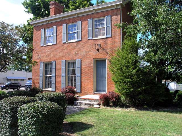
Photo: Chase Eckert, CC BY-SA 3.0 · Wikimedia Commons
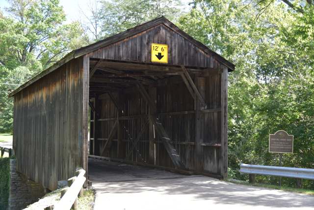
Photo: Paul Barrnes, CC BY-SA 4.0 · Wikimedia Commons
Local history sources: en.wikipedia.org · en.wikipedia.org · en.wikipedia.org · commons.wikimedia.org · commons.wikimedia.org
Historic places
2 places in Springfield Township, Hamilton County on the National Register of Historic Places. Press a pin or a name for its whole record.
-
Hill, Jediah, Covered BridgeStructure · Cincinnati · listed 1973
- Address
- 7 mi. N of Cincinnati off U.S. 127 on Covered Bridge Rd.
- Where
- Cincinnati, Hamilton County · ZIP 45231
- What it is
- Structure
- Listed on the National Register
- 1973
- NRIS reference number
- 73001460
- Coordinates
- 39.25588, -84.54939
National Register file (NPS) ↗ Search Wikipedia ↗ Street map and directions ↗ On the Cracked Buckeye map
-
Smith-Jessup HouseBuilding · Cincinnati · listed 1984
- Address
- 1038 W. North Bend Rd.
- Where
- Cincinnati, Hamilton County · ZIP 45224
- What it is
- Building
- Listed on the National Register
- 1984
- NRIS reference number
- 84003717
- Coordinates
- 39.20213, -84.52961
National Register file (NPS) ↗ Search Wikipedia ↗ Street map and directions ↗ On the Cracked Buckeye map
Source: National Park Service, National Register of Historic Places point file. The listing year is shown where NPS's certification date agrees with the listing's reference number. Listing recognizes significance; it does not restrict a private owner.
Water
13 wells in the Great Miami Buried Valley Aquifer along the Great Miami River near Fairfield, Butler Co. The water here
- Cincinnati Public Water System99% of residentsOhio River (Miller Plant, ~88%) plus Great Miami Buried Valley Aquifer wells (~12%)
- Wyoming City1% of residentsMill Creek valley aquifer (6 city wells)
- Reading City0% of residentsOhio River (Miller Plant, ~88%) plus Great Miami Buried Valley Aquifer wells (~12%)
Hospitals, fire stations and more
Inside Springfield Township, Hamilton County's boundary: 2 nursing homes, 3 fire and EMS stations, 1 college, 1 high-hazard dam, 3 public schools, 4 private schools, 1 police station, 2 public charging sites, 4 Toxics Release Inventory facilities and 14 spill cases. Press a pin or a name for its whole record and its source.
Nursing homes (2)
-
Burlington House Rehab & Alzheimer's Care Center Abuse citation3 of 5 stars · Cincinnati
- Address
- 2222 Springdale Road, Cincinnati, OH 45231
- Certified beds
- 122
- Residents on an average day
- 102
- Medicare overall rating
- 3 of 5 stars
- Health inspections
- 2 of 5 stars
- Staffing
- 3 of 5 stars
- Quality measures
- 5 of 5 stars
- Penalties since 2023
- none
- Abuse citation (CMS icon)
- Yes
- Ownership
- For profit - Limited Liability company
- Chain
- HEALTH CARE FACILITY MANAGEMENT, LLC
- Takes
- Medicare and Medicaid
- Phone
- (513) 851-7888
- Medicare ID
- 365892
Medicare Care Compare ↗ CMS nursing home data (source) ↗ Street map and directions ↗
-
Mt Airy Gardens Rehabilitation and Nursing Center2 of 5 stars · Cincinnati
- Address
- 2250 Banning Road, Cincinnati, OH 45239
- Certified beds
- 99
- Residents on an average day
- 94
- Medicare overall rating
- 2 of 5 stars
- Health inspections
- 2 of 5 stars
- Staffing
- 1 of 5 stars
- Quality measures
- 5 of 5 stars
- Penalties since 2023
- 1 fine totalling $10,039 (latest 2024-05-20)
- Ownership
- For profit - Corporation
- Takes
- Medicare and Medicaid
- Phone
- (513) 591-0400
- Medicare ID
- 365293
Medicare Care Compare ↗ CMS nursing home data (source) ↗ Street map and directions ↗
Source: CMS Care Compare nursing home provider and penalties files; Medicare star ratings run 1 to 5.
Fire and EMS stations (3)
-
Springfield Township Fire Department Station 75Cincinnati
- Address
- 10335 Burlington Road, Cincinnati, OH 45231
- Coordinates
- 39.26093, -84.55630
USGS National Map structures (source) ↗ Street map and directions ↗
-
Springfield Township Fire Department Station 81Springfield Township
- Address
- 777 West North Bend Road, Springfield Township, OH 45224
- Coordinates
- 39.20443, -84.51152
USGS National Map structures (source) ↗ Street map and directions ↗
-
Springfield Township Fire Station 79Cincinnati
- Address
- 9150 Winton Road, Cincinnati, OH 45231
- Coordinates
- 39.23225, -84.50925
USGS National Map structures (source) ↗ Street map and directions ↗
Source: USGS National Map structures (most Ohio records last updated 2019 to 2022), checked against the Columbus and Cleveland station lists. The department that answers a call is set by jurisdiction and mutual aid, not by distance.
Colleges (1)
-
Cincinnati College of Mortuary SciencePrivate nonprofit college · Cincinnati
- What it is
- Private nonprofit college
- City
- Cincinnati
- Students, 2023-24 (12-month count)
- 122
- IPEDS unit ID
- 201867
College Navigator (NCES) ↗ IPEDS data (source) ↗ Street map and directions ↗
Source: NCES IPEDS 2024 directory, 2023-24 enrollment and tuition, graduation rates for the 2017 (four-year) and 2020 (two-year) entering classes.
High-hazard dams (1)
-
West Fork of Mill Creek DamWest Fork of Mill Creek · condition: not available
- Hazard class
- High: a failure would probably cost a life
- Condition
- Not Available
- River or stream
- West Fork of Mill Creek
- Purpose
- Flood Risk Reduction;Recreation
- Type
- Earth
- Height
- 106 ft
- Storage
- 11,380 acre-feet
- Completed
- 1952
- Owner type
- Federal
- County
- Hamilton County
- Nearest town (NID)
- Woodland
- Last inspection
- 05/15/2025
- Emergency action plan
- Yes
- NID ID
- OH00029
National Inventory of Dams record ↗ National Inventory of Dams (source) ↗ Street map and directions ↗
Source: U.S. Army Corps of Engineers National Inventory of Dams, August 2026. "High hazard" rates what a failure would cost downstream, not how likely one is; the condition is the state's assessment.
Public schools (3)
-
Finneytown Elementary2 of 5 stars · Cincinnati
- Address
- 8850 Winton Rd, Cincinnati, OH 45231
- School district
- Finneytown Local School District
- Kind (NCES)
- Regular School
- Students, 2023-24
- 634
- Teachers (full-time equivalent)
- 36.6
- Report card, 2025-26
- 2 of 5 stars
- Performance index
- 54.4%
- Ohio building IRN
- 019940
- NCES school ID
- 390473310843
NCES school record ↗ Ohio School Report Card ↗ Street map and directions ↗
-
Finneytown Secondary Campus - Middle and High School3.5 of 5 stars · Cincinnati
- Address
- 8916 Fontainebleau Ter, Cincinnati, OH 45231
- School district
- Finneytown Local School District
- Kind (NCES)
- Regular School
- Students, 2023-24
- 536
- Teachers (full-time equivalent)
- 35.59
- Report card, 2025-26
- 3.5 of 5 stars
- Performance index
- 61.5%
- Four-year graduation rate
- 96.4%
- Ohio building IRN
- 011668
- NCES school ID
- 390473302840
NCES school record ↗ Ohio School Report Card ↗ Street map and directions ↗
-
Mt. Healthy North Elementary School3 of 5 stars · Cincinnati
- Address
- 2170 Struble Rd, Cincinnati, OH 45231
- School district
- Mount Healthy City School District
- Kind (NCES)
- Regular School
- Students, 2023-24
- 572
- Teachers (full-time equivalent)
- 49
- Report card, 2025-26
- 3 of 5 stars
- Performance index
- 55.6%
- Ohio building IRN
- 026658
- NCES school ID
- 390444101347
NCES school record ↗ Ohio School Report Card ↗ Street map and directions ↗
Source: NCES EDGE public school locations 2024-25 and Common Core of Data 2023-24 (type, students, teachers); Ohio School Report Cards 2025-26 (Department of Education and Workforce), matched by name within the district.
Private schools (4)
-
Central Baptist AcademyPrivate, religious, independent · Cincinnati
- Address
- 7645 Winton Rd, Cincinnati, OH 45224
- Kind
- religious, independent
- Students, 2023-24
- 104
- Teachers (full-time equivalent)
- 10.4
- Students per teacher
- 10
- Phone
- (513) 521-5481
- NCES private school ID
- 01064777
-
Central Montessori AcademyPrivate, nonsectarian, special program · Cincinnati
- Address
- 1904 Springdale Rd, Cincinnati, OH 45231
- Kind
- nonsectarian, special program
- Students, 2023-24
- 67
- Teachers (full-time equivalent)
- 9.9
- Students per teacher
- 6.76768
- Phone
- (513) 742-5800
- NCES private school ID
- K9304419
-
John Paul Ii Catholic SchoolPrivate, Catholic · Cincinnati
- Address
- 9375 Winton Rd, Cincinnati, OH 45231
- Kind
- Catholic
- Students, 2023-24
- 406
- Teachers (full-time equivalent)
- 27.6
- Students per teacher
- 14.7101
- Phone
- (513) 521-0860
- NCES private school ID
- 01055241
-
St Vivian SchoolPrivate, Catholic · Cincinnati
- Address
- 885 Denier Pl, Cincinnati, OH 45224
- Kind
- Catholic
- Students, 2023-24
- 214
- Teachers (full-time equivalent)
- 14.8
- Students per teacher
- 14.4595
- Phone
- (513) 522-6858
- NCES private school ID
- 01055627
Source: NCES Private School Survey 2023-24.
Police stations (1)
-
Springfield Township Police DepartmentCincinnati
- Address
- 1130 Compton Road, Cincinnati, OH 45231
- Coordinates
- 39.23453, -84.52584
USGS National Map structures (source) ↗ Street map and directions ↗
Source: USGS National Map structures, police stations, corrected and completed by hand (September 2026). The department that answers a call is set by jurisdiction, not by distance.
Public EV charging (2)
-
Brentwood Plaza DC fast4 DC fast · Cincinnati
- Address
- 939 Hempstead Dr, Cincinnati, OH 45231
- Ports
- 4 DC fast
- Plugs
- CCS, CHAdeMO
- Network
- eVgo Network
- Hours
- 24 hours daily
- Phone
- 877-455-3833
Station Locator (NREL) ↗ Alternative Fuels Data Center (source) ↗ Street map and directions ↗
-
Springfield Twp Admin Building Parking Lot4 Level 2 · Cincinnati
- Address
- 9158 Winton Road, Cincinnati, OH 45231
- Ports
- 4 Level 2
- Plugs
- J1772
- Network
- FLO
- Hours
- 24 hours daily
- Phone
- 888-356-8911
Station Locator (NREL) ↗ Alternative Fuels Data Center (source) ↗ Street map and directions ↗
Source: NREL Alternative Fuels Data Center station list (May 2026), public and open stations, the posts at one address counted as one site.
Facilities reporting toxic releases (4)
-
Denmark's Shoe RepairToxics Release Inventory · Springfield
- Address
- 555 Fake Street, Springfield, OH 20481
- County
- Montgomery County
- Status
- Reports to the Toxics Release Inventory
- EPA program ID
- 2048WDNMRK555FA
- EPA registry ID
- 110071256803
EPA facility record ↗ EPA Facility Registry Service (source) ↗ Street map and directions ↗
-
Parkway Prods IncToxics Release Inventory · Cincinnati
- Address
- 10293 Burlington Rd, Cincinnati, OH 45231
- County
- Hamilton County
- Status
- Reports to the Toxics Release Inventory (active)
- EPA program ID
- 45231PRKWY10293
- EPA registry ID
- 110000393547
EPA facility record ↗ EPA Facility Registry Service (source) ↗ Street map and directions ↗
-
Quantum Chemical Corp., U.S.I. DivisionToxics Release Inventory · Cincinnati
- Address
- 1275 Section Road, Cincinnati, OH 45237
- County
- Hamilton County
- Status
- Reports to the Toxics Release Inventory (active)
- EPA program ID
- 45237QNTMC1275S
- EPA registry ID
- 110001627142
EPA facility record ↗ EPA Facility Registry Service (source) ↗ Street map and directions ↗
-
Sherwin-Williams CoToxics Release Inventory · Cincinnati
- Address
- 145 Caldwell Dr, Cincinnati, OH 45216
- County
- Hamilton County
- Status
- Reports to the Toxics Release Inventory (active)
- EPA program ID
- 45216GNRLP145CA
- EPA registry ID
- 110000393306
EPA facility record ↗ EPA Facility Registry Service (source) ↗ Street map and directions ↗
Source: EPA Facility Registry Service, Toxics Release Inventory reporters. Reporting a release is required of large users of listed chemicals; it is not by itself a violation.
Spills reported since 2021 (14)
-
Oil Transformer Non Pcb2025-06-07 · Springfield Twp
- Reported
- 2025-06-07
- What spilled
- Oil Transformer Non Pcb
- Largest amount reported
- 9 gallons
- Where
- Springfield Twp, Hamilton County
- Ohio EPA district office
- SWDO
- Ohio EPA case number
- 2506EPA0000929
Ohio EPA spill reports (source) ↗ Street map and directions ↗
-
Other / All Other / Trade Name / Mixture / Solution Etc2025-03-27 · Springfield Twp
- Reported
- 2025-03-27
- What spilled
- Other / All Other / Trade Name / Mixture / Solution Etc
- Largest amount reported
- 200 gallons
- Where
- Springfield Twp, Hamilton County
- Ohio EPA district office
- SWDO
- Ohio EPA case number
- 2503EPA0000439
Ohio EPA spill reports (source) ↗ Street map and directions ↗
-
Material Unknown2025-02-27 · Springfield Twp
- Reported
- 2025-02-27
- What spilled
- Material Unknown; Fuel Gasoline ( 25% Ethanol Not E85)
- Where
- Springfield Twp, Hamilton County
- Ohio EPA district office
- SWDO
- Ohio EPA case number
- 2502EPA0000270
Ohio EPA spill reports (source) ↗ Street map and directions ↗
-
Natural Gas2024-12-19 · Springfield Twp
- Reported
- 2024-12-19
- What spilled
- Natural Gas
- Where
- Springfield Twp, Hamilton County
- Ohio EPA district office
- SWDO
- Ohio EPA case number
- 2412EPA0002045
Ohio EPA spill reports (source) ↗ Street map and directions ↗
-
Oil Hydraulic Fluid(S)2024-07-10 · Springfield Twp
- Reported
- 2024-07-10
- What spilled
- Oil Hydraulic Fluid(S)
- Largest amount reported
- 25 gallons
- Where
- Springfield Twp, Hamilton County
- Ohio EPA district office
- SWDO
- Ohio EPA case number
- 2407EPA0001158
Ohio EPA spill reports (source) ↗ Street map and directions ↗
-
Oil Hydraulic Fluid(S)2024-04-01 · Springfield Twp
- Reported
- 2024-04-01
- What spilled
- Oil Hydraulic Fluid(S)
- Largest amount reported
- 40 gallons
- Where
- Springfield Twp, Hamilton County
- Ohio EPA district office
- SWDO
- Ohio EPA case number
- 2404EPA0000506
Ohio EPA spill reports (source) ↗ Street map and directions ↗
-
Oil Hydraulic Fluid(S)2023-10-16 · Springfield Twp
- Reported
- 2023-10-16
- What spilled
- Oil Hydraulic Fluid(S)
- Largest amount reported
- 26 gallons
- Where
- Springfield Twp, Hamilton County
- Ohio EPA district office
- SWDO
- Ohio EPA case number
- 2310EPA0001781
Ohio EPA spill reports (source) ↗ Street map and directions ↗
-
Fat(S) / Oil / Grease / Tallow Food Types (Fog)2023-09-07 · Springfield Twp
- Reported
- 2023-09-07
- What spilled
- Fat(S) / Oil / Grease / Tallow Food Types (Fog)
- Where
- Springfield Twp, Hamilton County
- Ohio EPA district office
- SWDO
- Ohio EPA case number
- 2309EPA0001569
Ohio EPA spill reports (source) ↗ Street map and directions ↗
-
Sewage Sludge / Biosolids Reached water2023-05-28 · Springfield Twp
- Reported
- 2023-05-28
- What spilled
- Sewage Sludge / Biosolids
- Reached a waterway
- West Fork Mill Creek
- Where
- Springfield Twp, Hamilton County
- Ohio EPA district office
- SWDO
- Ohio EPA case number
- 2305EPA0000877
Ohio EPA spill reports (source) ↗ Street map and directions ↗
-
Sheen Rainbow / Hydrocarbon Reached water2023-05-13 · Springfield Twp
- Reported
- 2023-05-13
- What spilled
- Sheen Rainbow / Hydrocarbon
- Reached a waterway
- Woodward Creek
- Where
- Springfield Twp, Hamilton County
- Ohio EPA district office
- SWDO
- Ohio EPA case number
- 2305EPA0000780
Ohio EPA spill reports (source) ↗ Street map and directions ↗
-
Oil Hydraulic Fluid(S)2021-12-01 · Fairfield Twp
- Reported
- 2021-12-01
- What spilled
- Oil Hydraulic Fluid(S)
- Where
- Fairfield Twp, Butler County
- Ohio EPA district office
- SWDO
- Ohio EPA case number
- 2112EPA0001801
Ohio EPA spill reports (source) ↗ Street map and directions ↗
-
Waste Water2021-08-02 · Springfield Twp
- Reported
- 2021-08-02
- What spilled
- Waste Water
- Largest amount reported
- 10 gallons
- Where
- Springfield Twp, Hamilton County
- Ohio EPA district office
- SWDO
- Ohio EPA case number
- 2108EPA0001177
Ohio EPA spill reports (source) ↗ Street map and directions ↗
-
Sludge (Non-Sewage)2026-07-13 · Sycamore Twp
- Reported
- 2026-07-13
- What spilled
- Sludge (Non-Sewage)
- Where
- Sycamore Twp, Hamilton County
- Ohio EPA district office
- ESW
- Ohio EPA case number
- 2607EPA0001267
Ohio EPA spill reports (source) ↗ Street map and directions ↗
-
Oil Hydraulic Fluid(S)2026-01-21 · Springfield Twp
- Reported
- 2026-01-21
- What spilled
- Oil Hydraulic Fluid(S)
- Largest amount reported
- 20 gallons
- Where
- Springfield Twp, Hamilton County
- Ohio EPA district office
- SWDO
- Ohio EPA case number
- 2601EPA0000080
Ohio EPA spill reports (source) ↗ Street map and directions ↗
Source: Ohio EPA emergency response spill reports, 2021 to September 2026, one point per case where Ohio EPA placed it. A report is what the caller or responder recorded; amounts are often blank or estimated.
Its ZIP codes
Each ZIP code that touches Springfield Township, Hamilton County, with the share of its residents who live here and the same headline figures as the ZIP page.
Local government
Who holds office in Springfield Township, Hamilton County, how its elections and ballot issues came out, and the state auditor's record.
Money issues on the ballot since 2022: 2 of 2 passed; of those asking for new or higher taxes, 1 of 1.
Ballot issues
| Date | Issue | For | Against | Result |
|---|---|---|---|---|
| 2024-11-05 | Issue 24: PROPOSED TAX LEVY (ADDITIONAL) TOWNSHIP OF SPRINGFIELD | 10,337 | 8,137 | Passed (55.95% for) |
| 2022-11-08 | Issue 19: PROPOSED TAX LEVY (RENEWAL) TOWNSHIP OF SPRINGFIELD | 10,565 | 3,267 | Passed (76.38% for) |
Elections for office
| Date | Office | Candidates and votes |
|---|---|---|
| 2025-11-04 | Township Trustee | Saria N. W. Lattimore 3,968, 29.49%; Lisa M. Youngblood 3,882, 28.85%; Joe Honerlaw 2,877, 21.38%; Mark Berning 2,730, 20.29% |
| 2023-11-07 | Township Trustee | Sara Braun 5,847, 51.35%; Kristie Dukes Davis 5,539, 48.65% |
| 2023-11-07 | Township Fiscal Officer | Dan J. Berning 8,604, 100.0% |
| 2021-11-02 | Township Trustee | Joe Honerlaw 3,547, 35.93%; Mark R. Berning 3,177, 32.18%; Megan M. Dougherty 3,148, 31.89% |
Winners in bold. Results from the county board of elections' official canvass unless marked.
Auditor of State record
- No fiscal caution, watch or emergency on the Auditor of State's lists.
- Financial Audit, 2023 to 2024, released 2025-09-25
- Compliance Examination, 2023 to 2024, released 2025-08-12
The county
Hamilton County: 54 ZIP codes, 47 cities, villages and townships, 843,791 people.
Nearby places
Quick answers
What county is Springfield Township, Ohio in?
Springfield Township, Hamilton County is a township in Hamilton County, Ohio, with 35,862 residents.
When was Springfield Township, Ohio founded?
Springfield Township, Hamilton County was incorporated 1795 (township organized). Founders on record: the court of general quarter sessions, out of the northern part of Cincinnati Township. Source
What ZIP code is Springfield Township, Ohio?
Springfield Township, Hamilton County is served by ZIP codes 45231, 45240, 45224, 45216 and 45218; 45231 holds the largest share of its residents.
Where does Springfield Township, Ohio get its water?
The main water source for Springfield Township, Hamilton County (Cincinnati Public Water System): 13 wells in the Great Miami Buried Valley Aquifer along the Great Miami River near Fairfield, Butler Co.
Cite this page
Cite this page as:
Cracked Buckeye, "Springfield Township, Hamilton County", https://crackedbuckeye.com/place/springfield-township-hamilton-county/, built 2026-10-31, accessed [date].
How to cite · Report a correction · Built 2026-10-31
