Local events in Sharon Township, Noble County
Nothing is posted for Sharon Township itself yet; here is what is on within 20 miles. All local events in Sharon Township, Noble County
Know a calendar we should watch? Send the link
Checked October 20; the events page is refreshed daily.
How Sharon Township, Noble County began
Sharon Township, in the western part of Noble County along Olive Green Creek, was erected by the Noble County commissioners on May 1, 1851, from fractional townships taken from Morgan County; before Morgan County was formed in 1819 its southern half belonged to Washington County and its northern half to Guernsey. The hunter Samuel Sailor squatted south of the present village before 1815, and James Archibald's family, who arrived on April 5, 1815, made the first permanent settlement. The village of Sharon, platted in 1831, became a tobacco and pork-packing town with Presbyterian, United Presbyterian and Methodist churches, the county's first steam flour mill (1846) and Sharon College (1852-1875); Isaac Parrish, the county's first lawyer and twice a congressman, lived here. The township is named for Sharon, Connecticut; in 1925 the bow of the airship Shenandoah came down near the village.
Settled 1815 (James Archibald family, April 5, 1815); Samuel Sailor squatted south of Sharon a year or two earlier, platted village of Sharon, March 1831, for Robert Rutherford and Edward Parrish (14 lots), incorporated township erected May 1, 1851 by the Noble County commissioners, by James Archibald; Samuel Sailor recorded as an earlier hunter-squatter.
Where the name comes from
Sharon Township takes its name from Sharon, Connecticut, according to the township's Wikipedia article, which cites William D. Overman's Ohio Town Names (1958); it is one of four Sharon Townships in Ohio. The village of Sharon predates the township by twenty years, and no source read explains who chose the name.
Before the town
No Native American village, trail, mound or documented encounter specific to Sharon Township was found in the sources read. The 1887 county history describes the waters of Olive Green Creek as a favorite hunting ground to which hunters came from Zanesville and farther, but it refers to white hunters. Martin's 1904 history says that for years after settlement began some Native hunters paid yearly visits to their former hunting grounds in the county without hostility. Recorded settlement begins in 1815, two decades after the Treaty of Greenville.
Timeline
- — The Archibald family, who left their home a mile west of St. Clairsville on March 26, reached their new land south of Sharon, cutting part of their own road; James Archibald's was probably the first permanent family in the township.
- — Archibald entered the land on which Samuel Sailor had squatted; the two went to law over Sailor's improvements, walking with their witnesses about thirty miles to court at Cambridge, each carrying a rifle.
- — William Wiley died and was the first person buried in the old graveyard at Sharon, on half an acre he had given for burials.
- — The Center road from McConnelsville to Woodsfield was opened through the township; an old resident recalled that before this there were no roads near Sharon.
- — Isaac Parrish, the first lawyer in what became Noble County and later twice a member of Congress, settled in the township.
- — A log schoolhouse and, about this year, a church shared by Presbyterians and United Presbyterians were the first buildings on the site of Sharon village.
- — A post office was established at Sharon through the efforts of the Rev. Robert Rutherford, its first postmaster, with weekly mail on the route between Barnesville and McConnelsville.
- — The village of Sharon was laid out in March on land of Robert Rutherford and Edward Parrish; the original plat had fourteen lots.
- — James McGlashan was running a carding machine on Olive Green Creek; he later moved it into Sharon.
- — Three churches were built in Sharon in one year: Presbyterian, United Presbyterian and Methodist Episcopal.
- — Isaac Parrish built a steam flour mill at Sharon, probably the earliest steam mill in the county; Sharon Lodge No. 136 of the Masons was instituted on March 26 of the same year.
- — The Sharon Railroad Company was incorporated by Isaac Parrish and others with $30,000 capital to build a line from Sharon to the Muskingum River; grading began but the capital proved insufficient.
- — Sharon Township took its present boundary of 27 sections when the Noble County commissioners erected it on May 1.
- — The Rev. Randall Ross opened Sharon College, which taught languages and higher branches and ran until 1875.
- — James Caldwell opened the first store at Olive Green, in the township, and Jacob Swank began building a mill there; the Olive Green post office followed in 1857.
- — The census counted 1,221 people in Sharon Township.
- — The Parrish Covered Bridge over the Sharon Fork of Olive Green Creek was rebuilt following flood damage.
- — When the Navy airship Shenandoah broke apart over Noble County, its bow floated about six miles south of the breakup before landing at the Ernest Nichols farm west of the Sharon crossroads.
Stories
Samuel Sailor, hunter and neighbor
Samuel Sailor came from Washington County, Pennsylvania, before 1815, built a camp south of the site of Sharon and lived by hunting; he said he once went seven weeks without seeing another person. After losing his claim to Archibald he moved to the western part of the township, where he died in 1871 at about eighty-eight. His nearest neighbor there was a Mr. Brown, five miles off at the forks of Olive Green Creek. Seeing two suspicious men heading for Brown's cabin while Brown was away, Sailor followed with his gun, found them making Mrs. Brown serve them a meal, knocked both down and threw them out, and stayed the night to guard the cabin. Another time he carried a keg of whisky home on his shoulders from Archer's distillery near East Union for his own house-raising, opened it on the way, and arrived at two in the afternoon, after the house was already up.
The Archibald wagon
James Archibald, born in Ireland and married in Pennsylvania, brought his family from Belmont County, a mile west of St. Clairsville, starting on March 26, 1815, and reached their land south of Sharon on April 5. They set out with a wagon and for part of the way had to cut their own road. Along the route they left behind all of the wagon except its two front wheels, and they blazed trees so they could find their way back. Archibald later planted one of the first orchards in the region: he and John McKee went to Belpre on the Ohio with an ox team and brought back three hundred trees, and people came from a distance for the fruit. His son John served more than twenty years as a justice of the peace.
The post-boy and the Pall Mall Gazette
When the Sharon post office opened in 1830 only two newspapers came to the whole route: Peter Ackley took the London Pall Mall Gazette and John Lyons the Pittsburgh Christian Advocate. Often the weekly mail carried no letter for anyone along the line, and a letter from any distance cost the receiver twenty-five cents. The carrier was a boy on horseback with a tin trumpet, which he blew to announce himself; the 1887 county history says the boys along his route looked on him as hardly less important than General Jackson. Whoever got a letter usually shared its contents with the neighbors at the first chance.
A county seat that was never built
Until Morgan County was formed in 1819, the southern half of what is now Sharon Township belonged to Washington County and the northern half to Guernsey. When Morgan County was created, some settlers hoped to have its county seat placed here, on land then owned by Isaac Hill that later became the Edward Parrish farm. Land was cleared and logs were cut on the Joseph Parrish farm for a temporary courthouse, and four parties entered a full section of land for the seat of justice. The plan came to nothing, and the 1887 history marks the failure with a line from Burns about the best laid plans.
Photographs
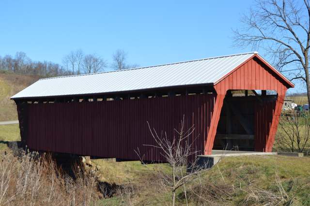
Photo: Nyttend, public domain · Wikimedia Commons
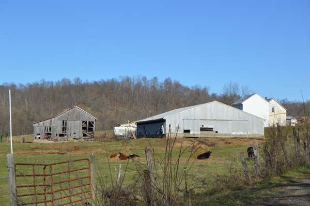
Photo: Nyttend, public domain · Wikimedia Commons
Local history sources: en.wikipedia.org · archive.org · archive.org · archive.org · archive.org · remarkableohio.org · en.wikipedia.org · waymarking.com · en.wikipedia.org · en.wikipedia.org · en.wikipedia.org · commons.wikimedia.org · commons.wikimedia.org · nps.gov
Water
Mostly private wells The water here
- Caldwell Village79% of residentsWolf Run Lake (primary) + Caldwell Lake (backup reservoirs)
- Pure Water Corporation11% of residentsWolf Run Lake (primary) + Caldwell Lake (backup reservoirs)
- Noble County Water Authority5% of residentsWolf Run Lake (primary) + Caldwell Lake (backup reservoirs)
- Pure Water System 23% of residentsWolf Run Lake (primary) + Caldwell Lake (backup reservoirs)
- Noble Water Company2% of residentsWolf Run Lake (primary) + Caldwell Lake (backup reservoirs)
- Clear Water Corporation0% of residentsWolf Run Lake (primary) + Caldwell Lake (backup reservoirs)
Hospitals, fire stations and more
Inside Sharon Township, Noble County's boundary: 2 poor-rated bridges, 6 shale and injection wells and 2 spill cases. Press a pin or a name for its whole record and its source.
Bridges rated poor (2)
-
County Road 8 over Sharon ForkPoor · built 1900
- Condition
- Poor: a deck, superstructure, substructure or culvert rated 4 or below on the 0 to 9 scale
- What it is
- Bridge
- Built
- 1900
- Length
- 26 ft
- Owner
- County
- Vehicles a day
- 67
- Coordinates
- 39.70611, -81.58499
National Bridge Inventory (source) ↗ Street map and directions ↗
-
Township Road 3 over Green CreekPoor · built 1996
- Condition
- Poor: a deck, superstructure, substructure or culvert rated 4 or below on the 0 to 9 scale
- What it is
- Culvert
- Built
- 1996
- Length
- 13 ft
- Owner
- County
- Vehicles a day
- 96
- Coordinates
- 39.71615, -81.61668
National Bridge Inventory (source) ↗ Street map and directions ↗
Source: FHWA National Bridge Inventory 2025. "Poor" means one major part rated 4 or below on the 0 to 9 scale; it calls for repair, not closing, unless the state posts or closes the bridge.
Shale and injection wells (6)
-
Cheetah Nsh 2CUtica shale well
- What it is
- Utica shale well
- Drilled sideways
- Yes
- Operator
- Eog Resources Inc.
- County
- Noble County
- API well number
- 34121247010000
- Coordinates
- 39.70173, -81.59992
ODNR oil and gas wells (source) ↗ Street map and directions ↗
The point is the surface well head (the pad); a horizontal well runs a mile or more underground from it.
-
Cheetah Nsh 4CUtica shale well
- What it is
- Utica shale well
- Drilled sideways
- Yes
- Operator
- Eog Resources Inc.
- County
- Noble County
- API well number
- 34121247020000
- Coordinates
- 39.70168, -81.59992
ODNR oil and gas wells (source) ↗ Street map and directions ↗
The point is the surface well head (the pad); a horizontal well runs a mile or more underground from it.
-
Cheetah Nsh 6C-XUtica shale well
- What it is
- Utica shale well
- Drilled sideways
- Yes
- Operator
- Eog Resources Inc.
- County
- Noble County
- API well number
- 34121247040000
- Coordinates
- 39.70160, -81.59992
ODNR oil and gas wells (source) ↗ Street map and directions ↗
The point is the surface well head (the pad); a horizontal well runs a mile or more underground from it.
-
Frec Nobl Sharon A-1HUtica shale well
- What it is
- Utica shale well
- Drilled sideways
- Yes
- Operator
- Eog Resources Inc.
- County
- Noble County
- API well number
- 34121243480100
- Coordinates
- 39.72201, -81.60990
ODNR oil and gas wells (source) ↗ Street map and directions ↗
The point is the surface well head (the pad); a horizontal well runs a mile or more underground from it.
-
H. Dudley {Swiw #1} 1 InjectionInjection well (Class II)
- What it is
- Injection well (Class II)
- Operator
- Buckshot Disposal Llc
- County
- Noble County
- API well number
- 34121224590000
- Coordinates
- 39.74641, -81.59961
ODNR oil and gas wells (source) ↗ Street map and directions ↗
-
Morris W D (Swiw #9) 3 InjectionInjection well (Class II)
- What it is
- Injection well (Class II)
- Operator
- Northwood Energy Corp
- County
- Noble County
- API well number
- 34121242500000
- Coordinates
- 39.66531, -81.58914
ODNR oil and gas wells (source) ↗ Street map and directions ↗
Source: ODNR Division of Oil and Gas Resources well inventory (September 2026): drilled Utica, Marcellus and horizontal wells and Class II injection wells not plugged. Older vertical wells are on the full map.
Spills reported since 2021 (2)
-
Sheen Rainbow / Hydrocarbon2024-01-10 · Sharon Twp
- Reported
- 2024-01-10
- What spilled
- Sheen Rainbow / Hydrocarbon
- Where
- Sharon Twp, Noble County
- Ohio EPA district office
- SEDO
- Ohio EPA case number
- 2401EPA0000059
Ohio EPA spill reports (source) ↗ Street map and directions ↗
-
Brine Oil And Gas Related Reached water2022-06-09 · Sharon Twp
- Reported
- 2022-06-09
- What spilled
- Brine Oil And Gas Related
- Reached a waterway
- 61 - Limestone Run
- Where
- Sharon Twp, Noble County
- Ohio EPA district office
- SEDO
- Ohio EPA case number
- 2206EPA0000863
Ohio EPA spill reports (source) ↗ Street map and directions ↗
Source: Ohio EPA emergency response spill reports, 2021 to September 2026, one point per case where Ohio EPA placed it. A report is what the caller or responder recorded; amounts are often blank or estimated.
Its ZIP codes
Each ZIP code that touches Sharon Township, Noble County, with the share of its residents who live here and the same headline figures as the ZIP page.
| ZIP | Share | Water | Radon | Home value | Schools | Flood |
|---|---|---|---|---|---|---|
| 43724 Olive Township and Caldwell | 4% | Mostly private wells | 8.2 pCi/L average radon | Appraisal records without year built | Caldwell Exempted Village · 3 stars overall | 2.8% of residents in the 1% floodplain |
Local government
Who holds office in Sharon Township, Noble County, how its elections and ballot issues came out, and the state auditor's record.
Elections for office
| Date | Office | Candidates and votes |
|---|---|---|
| 2021-11-02 | Township Trustee | David Reed 64, 72.73%; Write-In: Michael Bettinger 18, 20.45% |
| 2019-11-05 | Township Trustee | John Byer 42, 42.86%; Duane Parcell 56, 57.14% |
| 2019-11-05 | Township Fiscal Officer | Angel D. Cain 77, 100.0% |
Winners in bold. Results from the county board of elections' official canvass unless marked.
Auditor of State record
- No fiscal caution, watch or emergency on the Auditor of State's lists.
- Financial Audit, 2022 to 2023, released 2025-05-27
The county
Noble County: 6 ZIP codes, 14 cities, villages and townships, 11,290 people.
Nearby places
Quick answers
What county is Sharon Township, Ohio in?
Sharon Township, Noble County is a township in Noble County, Ohio, with 329 residents.
When was Sharon Township, Ohio founded?
Sharon Township, Noble County was settled 1815 (James Archibald family, April 5, 1815); Samuel Sailor squatted south of Sharon a year or two earlier; laid out village of Sharon, March 1831, for Robert Rutherford and Edward Parrish (14 lots); incorporated township erected May 1, 1851 by the Noble County commissioners. Founders on record: James Archibald; Samuel Sailor recorded as an earlier hunter-squatter. Source
How did Sharon Township, Ohio get its name?
Sharon Township takes its name from Sharon, Connecticut, according to the township's Wikipedia article, which cites William D. Source
What ZIP code is Sharon Township, Ohio?
Most of Sharon Township, Noble County is in ZIP code 43724.
Where does Sharon Township, Ohio get its water?
The main water source for Sharon Township, Noble County (Caldwell Village): Mostly private wells.
Cite this page
Cite this page as:
Cracked Buckeye, "Sharon Township, Noble County", https://crackedbuckeye.com/place/sharon-township-noble-county/, built 2026-10-31, accessed [date].
How to cite · Report a correction · Built 2026-10-31