Local events in Pease Township, Belmont County
Nothing is posted for Pease Township itself yet; here is what is on within 10 miles. All local events in Pease Township, Belmont County
Know a calendar we should watch? Send the link
Checked October 20; the events page is refreshed daily.
How Pease Township, Belmont County began
Pease Township was organized in 1806 in Belmont County's northeastern corner along the Ohio River, named for an early judge. By 1833 it held four flouring mills, a woolen and a cotton factory, and a scattering of gristmills and sawmills. Its best-known landmark sits at the unincorporated community of Blaine on the township's western edge: the Blaine Hill "S" Bridge, three stone arches carrying the National Road across Wheeling Creek since the late 1820s in a deliberate S-curve, now recognized as the oldest standing bridge in Ohio. The cities of Martins Ferry, Bridgeport, and Brookside, and the village of Yorkville, are also within the township's boundaries, though each has its own page.
Incorporated 1806, by Belmont County commissioners.
Where the name comes from
Named for Pease, an early judge; no further identifying detail was found in the sources consulted.
Before the town
No Native village, camp, or trail specific to Pease Township was found in the sources consulted. The township's Ohio River frontage, facing Ohio County, West Virginia, lay within the general eighteenth-century Lenape, Shawnee, Wyandot, and Mingo travel and hunting range.
Timeline
- — Pease Township is organized, named for an early judge.
- — Construction of the Blaine Hill 'S' Bridge, carrying the National Road across Wheeling Creek on three stone arches spanning roughly 385 feet, begins under contractors James Lloyd and Robert Wilson of Hagerstown, Maryland.
- — The Blaine Hill 'S' Bridge is completed (some sources give 1826), easing the National Road's roughly 500-foot climb out of the Wheeling Creek valley at about a 6.3 percent grade.
- — The township is recorded as containing four flouring mills, a woolen factory, a cotton factory, and a number of gristmills and sawmills.
- — The Blaine Hill Viaduct is built alongside the old 'S' Bridge to carry growing automobile traffic on the National Road, which by then averaged about 2,700 vehicles a day.
- — The opening of Interstate 70 diverts most remaining traffic away from the old National Road route past Blaine.
- — The crumbling Blaine Hill 'S' Bridge is saved from demolition.
- — The bridge is designated Ohio's official Bicentennial Bridge.
- — The Blaine Hill 'S' Bridge is added to the National Register of Historic Places on March 17.
Stories
Ohio's oldest standing bridge, built to bend around a hill
When engineers laid the National Road across the hill above Wheeling Creek at Blaine in the 1820s, they faced a problem: a bridge crosses a stream most cheaply when it meets the water at a right angle, but the road needed to run as straight and level as the terrain allowed. Contractors James Lloyd and Robert Wilson of Hagerstown, Maryland, solved it the way road builders did at several other Ohio crossings, by bending the roadway itself into an S-curve on the bridge's approaches, so three stone arches spanning roughly 385 feet could sit square to the creek while easing the road's roughly 500-foot climb out of the valley to about a 6.3 percent grade, a major improvement for the horse- and ox-drawn traffic of the day. Finished around 1828, the bridge carried National Road traffic for over a century until a modern viaduct was built beside it in 1933 and Interstate 70 finally routed most travelers around it entirely in 1964. Left to crumble, it was rescued from demolition in 1999, named Ohio's official Bicentennial Bridge in 2003, and listed on the National Register in 2010; it is recognized today as the oldest standing bridge in the state.
Photographs
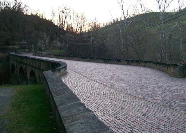
Photo: Bwsmith84, Wikimedia Commons, CC BY 3.0 · Wikimedia Commons
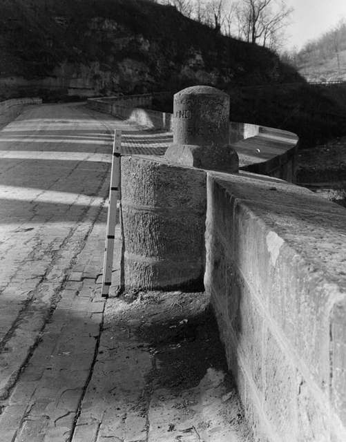
Photo: Historic American Buildings Survey, Library of Congress, public domain · Wikimedia Commons
Local history sources: en.wikipedia.org · en.wikipedia.org · historicbridges.org · highways.dot.gov · en.wikipedia.org · commons.wikimedia.org · commons.wikimedia.org
Historic places
1 place in Pease Township, Belmont County on the National Register of Historic Places. Press a pin or a name for its whole record.
-
Blaine Hill "S" BridgeStructure · Blane, Pease Township · listed 2010
- Address
- Township Rd. 649
- Where
- Blane, Pease Township, Belmont County · ZIP 43950
- What it is
- Structure
- Listed on the National Register
- 2010
- NRIS reference number
- 10000082
- Coordinates
- 40.06692, -80.82083
National Register file (NPS) ↗ Search Wikipedia ↗ Street map and directions ↗ On the Cracked Buckeye map
Source: National Park Service, National Register of Historic Places point file. The listing year is shown where NPS's certification date agrees with the listing's reference number. Listing recognizes significance; it does not restrict a private owner.
Water
Mostly private wells The water here
- Belmont Co. Sanitary District 339% of residentsOhio River valley aquifer (wells)
- Martins Ferry Public Water System34% of residentsOhio River valley aquifer (wells)
- Bridgeport Public Water System24% of residentsOhio River valley aquifer (wells)
- Bellaire Public Water System2% of residentsOhio River (via bank infiltration wells)
- Rayland Village1% of residentsGroundwater wells (2 wells)
- Warren Water Authority0% of residentsGroundwater wells (2 wells)
- St. Clairsville, City Of0% of residentsSt. Clairsville Main & Provident Reservoirs (local runoff)
- Yorkville Village0% of residentsGroundwater wells (2 wells)
- Dillonvale0% of residentsGroundwater wells (2 wells)
Hospitals, fire stations and more
Inside Pease Township, Belmont County's boundary: 1 nursing home, 2 fire and EMS stations, 1 college, 3 public schools, 3 poor-rated bridges, 33 shale and injection wells, 2 Superfund sites and 7 spill cases. Press a pin or a name for its whole record and its source.
Nursing homes (1)
-
Rolling Hills Rehab and Care Ctr Abuse citation1 of 5 stars · Bridgeport
- Address
- 68222 Commercial Drive, Bridgeport, OH 43912
- Certified beds
- 75
- Residents on an average day
- 62
- Medicare overall rating
- 1 of 5 stars
- Health inspections
- 1 of 5 stars
- Staffing
- 1 of 5 stars
- Quality measures
- 3 of 5 stars
- Penalties since 2023
- 1 fine totalling $92,336, 1 payment denial (latest 2025-08-11)
- Abuse citation (CMS icon)
- Yes
- Special focus facility
- SFF Candidate
- Ownership
- For profit - Limited Liability company
- Chain
- NORTHWOOD HEALTHCARE GROUP
- Takes
- Medicare and Medicaid
- Phone
- (740) 635-4600
- Medicare ID
- 365559
Medicare Care Compare ↗ CMS nursing home data (source) ↗ Street map and directions ↗
Source: CMS Care Compare nursing home provider and penalties files; Medicare star ratings run 1 to 5.
Fire and EMS stations (2)
-
Sunset Heights Volunteer Fire DepartmentBridgeport
- Address
- 69604 Sunset Heights, Bridgeport, OH 43912
- Coordinates
- 40.09442, -80.76085
USGS National Map structures (source) ↗ Street map and directions ↗
-
Wolfhurst Volunteer Fire Department Station 41Bridgeport
- Address
- 55485 Brand Avenue, Bridgeport, OH 43912
- Coordinates
- 40.07032, -80.78331
USGS National Map structures (source) ↗ Street map and directions ↗
Source: USGS National Map structures (most Ohio records last updated 2019 to 2022), checked against the Columbus and Cleveland station lists. The department that answers a call is set by jurisdiction and mutual aid, not by distance.
Colleges (1)
-
Elite Academy of Hair DesignFor-profit career school · Bridgeport
- What it is
- For-profit career school
- City
- Bridgeport
- Students, 2023-24 (12-month count)
- 107
- IPEDS unit ID
- 492005
College Navigator (NCES) ↗ IPEDS data (source) ↗ Street map and directions ↗
Source: NCES IPEDS 2024 directory, 2023-24 enrollment and tuition, graduation rates for the 2017 (four-year) and 2020 (two-year) entering classes.
Public schools (3)
-
The Bridgeport School District - Elementary4.5 of 5 stars · Bridgeport
- Address
- 55707 Industrial Dr, Bridgeport, OH 43912
- School district
- Bridgeport Ex Vill School District
- Kind (NCES)
- Regular School
- Students, 2023-24
- 353
- Teachers (full-time equivalent)
- 18
- Report card, 2025-26
- 4.5 of 5 stars
- Performance index
- 90.6%
- Ohio building IRN
- 040618
- NCES school ID
- 390452302131
NCES school record ↗ Ohio School Report Card ↗ Street map and directions ↗
-
The Bridgeport School District - High School3 of 5 stars · Bridgeport
- Address
- 55707 Industrial Dr, Bridgeport, OH 43912
- School district
- Bridgeport Ex Vill School District
- Kind (NCES)
- Regular School
- Students, 2023-24
- 167
- Teachers (full-time equivalent)
- 18
- Report card, 2025-26
- 3 of 5 stars
- Performance index
- 68.2%
- Four-year graduation rate
- 95.5%
- Ohio building IRN
- 003558
- NCES school ID
- 390452302128
NCES school record ↗ Ohio School Report Card ↗ Street map and directions ↗
-
The Bridgeport School DIstrict - Middle School2 of 5 stars · Bridgeport
- Address
- 55707 Industrial Dr, Bridgeport, OH 43912
- School district
- Bridgeport Ex Vill School District
- Kind (NCES)
- Regular School
- Students, 2023-24
- 225
- Teachers (full-time equivalent)
- 15
- Report card, 2025-26
- 2 of 5 stars
- Performance index
- 68.9%
- Ohio building IRN
- 019190
- NCES school ID
- 390452302129
NCES school record ↗ Ohio School Report Card ↗ Street map and directions ↗
Source: NCES EDGE public school locations 2024-25 and Common Core of Data 2023-24 (type, students, teachers); Ohio School Report Cards 2025-26 (Department of Education and Workforce), matched by name within the district.
Bridges rated poor (3)
-
CR 4 over Glenns RunPoor · built 1993
- Condition
- Poor: a deck, superstructure, substructure or culvert rated 4 or below on the 0 to 9 scale
- What it is
- Bridge
- Built
- 1993
- Length
- 22 ft
- Owner
- County
- Vehicles a day
- 1,054
- Coordinates
- 40.11674, -80.72198
National Bridge Inventory (source) ↗ Street map and directions ↗
-
TR 472 over Little Short CreekPoor · built 1960
- Condition
- Poor: a deck, superstructure, substructure or culvert rated 4 or below on the 0 to 9 scale
- What it is
- Bridge
- Built
- 1960
- Length
- 11 ft
- Owner
- County
- Vehicles a day
- 209
- Coordinates
- 40.15139, -80.76750
National Bridge Inventory (source) ↗ Street map and directions ↗
-
US 40 over Whlng Cr Cr.10 & Abnd.rrPoor · built 1932
- Condition
- Poor: a deck, superstructure, substructure or culvert rated 4 or below on the 0 to 9 scale
- What it is
- Bridge
- Built
- 1932
- Length
- 230 ft
- Owner
- State
- Vehicles a day
- 7,734
- Coordinates
- 40.06661, -80.82135
National Bridge Inventory (source) ↗ Street map and directions ↗
Source: FHWA National Bridge Inventory 2025. "Poor" means one major part rated 4 or below on the 0 to 9 scale; it calls for repair, not closing, unless the state posts or closes the bridge.
Shale and injection wells (33)
-
Finney Pes Bl 1HUtica shale well
- What it is
- Utica shale well
- Drilled sideways
- Yes
- Operator
- Ascent Resources Utica Llc
- County
- Belmont County
- API well number
- 34013209380000
- Coordinates
- 40.15431, -80.77919
ODNR oil and gas wells (source) ↗ Street map and directions ↗
The point is the surface well head (the pad); a horizontal well runs a mile or more underground from it.
-
Freund 210494 4AUtica shale well
- What it is
- Utica shale well
- Drilled sideways
- Yes
- Operator
- Gulfport Appalachia Llc
- County
- Belmont County
- API well number
- 34013215530000
- Coordinates
- 40.07543, -80.77502
ODNR oil and gas wells (source) ↗ Street map and directions ↗
The point is the surface well head (the pad); a horizontal well runs a mile or more underground from it.
-
Freund 210497 2AUtica shale well
- What it is
- Utica shale well
- Drilled sideways
- Yes
- Operator
- Gulfport Appalachia Llc
- County
- Belmont County
- API well number
- 34013215510000
- Coordinates
- 40.07536, -80.77496
ODNR oil and gas wells (source) ↗ Street map and directions ↗
The point is the surface well head (the pad); a horizontal well runs a mile or more underground from it.
-
Freund 210498 3AUtica shale well
- What it is
- Utica shale well
- Drilled sideways
- Yes
- Operator
- Gulfport Appalachia Llc
- County
- Belmont County
- API well number
- 34013215520000
- Coordinates
- 40.07539, -80.77499
ODNR oil and gas wells (source) ↗ Street map and directions ↗
The point is the surface well head (the pad); a horizontal well runs a mile or more underground from it.
-
Freund 211801 1AUtica shale well
- What it is
- Utica shale well
- Drilled sideways
- Yes
- Operator
- Gulfport Appalachia Llc
- County
- Belmont County
- API well number
- 34013215500000
- Coordinates
- 40.07533, -80.77492
ODNR oil and gas wells (source) ↗ Street map and directions ↗
The point is the surface well head (the pad); a horizontal well runs a mile or more underground from it.
-
Lance 210966 4BUtica shale well
- What it is
- Utica shale well
- Drilled sideways
- Yes
- Operator
- Gulfport Appalachia Llc
- County
- Belmont County
- API well number
- 34013212840000
- Coordinates
- 40.12682, -80.75307
ODNR oil and gas wells (source) ↗ Street map and directions ↗
The point is the surface well head (the pad); a horizontal well runs a mile or more underground from it.
-
Lance 210966 6AUtica shale well
- What it is
- Utica shale well
- Drilled sideways
- Yes
- Operator
- Gulfport Appalachia Llc
- County
- Belmont County
- API well number
- 34013212780000
- Coordinates
- 40.12681, -80.75318
ODNR oil and gas wells (source) ↗ Street map and directions ↗
The point is the surface well head (the pad); a horizontal well runs a mile or more underground from it.
-
Lance 210967 7AUtica shale well
- What it is
- Utica shale well
- Drilled sideways
- Yes
- Operator
- Gulfport Appalachia Llc
- County
- Belmont County
- API well number
- 34013212860000
- Coordinates
- 40.12681, -80.75323
ODNR oil and gas wells (source) ↗ Street map and directions ↗
The point is the surface well head (the pad); a horizontal well runs a mile or more underground from it.
-
Lance 210970 1CUtica shale well
- What it is
- Utica shale well
- Drilled sideways
- Yes
- Operator
- Gulfport Appalachia Llc
- County
- Belmont County
- API well number
- 34013212940000
- Coordinates
- 40.12682, -80.75291
ODNR oil and gas wells (source) ↗ Street map and directions ↗
The point is the surface well head (the pad); a horizontal well runs a mile or more underground from it.
-
Lance 210970 3BUtica shale well
- What it is
- Utica shale well
- Drilled sideways
- Yes
- Operator
- Gulfport Appalachia Llc
- County
- Belmont County
- API well number
- 34013212830000
- Coordinates
- 40.12682, -80.75302
ODNR oil and gas wells (source) ↗ Street map and directions ↗
The point is the surface well head (the pad); a horizontal well runs a mile or more underground from it.
-
Lance 210970 5AUtica shale well
- What it is
- Utica shale well
- Drilled sideways
- Yes
- Operator
- Gulfport Appalachia Llc
- County
- Belmont County
- API well number
- 34013212770000
- Coordinates
- 40.12681, -80.75312
ODNR oil and gas wells (source) ↗ Street map and directions ↗
The point is the surface well head (the pad); a horizontal well runs a mile or more underground from it.
-
Lance 211400 2AUtica shale well
- What it is
- Utica shale well
- Drilled sideways
- Yes
- Operator
- Gulfport Appalachia Llc
- County
- Belmont County
- API well number
- 34013212820000
- Coordinates
- 40.12682, -80.75297
ODNR oil and gas wells (source) ↗ Street map and directions ↗
The point is the surface well head (the pad); a horizontal well runs a mile or more underground from it.
-
Mckeegan 210717 3BUtica shale well
- What it is
- Utica shale well
- Drilled sideways
- Yes
- Operator
- Gulfport Appalachia Llc
- County
- Belmont County
- API well number
- 34013213590000
- Coordinates
- 40.15499, -80.74136
ODNR oil and gas wells (source) ↗ Street map and directions ↗
The point is the surface well head (the pad); a horizontal well runs a mile or more underground from it.
-
Mckeegan 210717 5AUtica shale well
- What it is
- Utica shale well
- Drilled sideways
- Yes
- Operator
- Gulfport Appalachia Llc
- County
- Belmont County
- API well number
- 34013213610000
- Coordinates
- 40.15491, -80.74140
ODNR oil and gas wells (source) ↗ Street map and directions ↗
The point is the surface well head (the pad); a horizontal well runs a mile or more underground from it.
-
Mckeegan 210947 4AUtica shale well
- What it is
- Utica shale well
- Drilled sideways
- Yes
- Operator
- Gulfport Appalachia Llc
- County
- Belmont County
- API well number
- 34013213600000
- Coordinates
- 40.15495, -80.74138
ODNR oil and gas wells (source) ↗ Street map and directions ↗
The point is the surface well head (the pad); a horizontal well runs a mile or more underground from it.
-
Mckeegan 211723 1AUtica shale well
- What it is
- Utica shale well
- Drilled sideways
- Yes
- Operator
- Gulfport Appalachia Llc
- County
- Belmont County
- API well number
- 34013213580000
- Coordinates
- 40.15506, -80.74132
ODNR oil and gas wells (source) ↗ Street map and directions ↗
The point is the surface well head (the pad); a horizontal well runs a mile or more underground from it.
-
Pol Pes Bl 1HUtica shale well
- What it is
- Utica shale well
- Drilled sideways
- Yes
- Operator
- Ascent Resources Utica Llc
- County
- Belmont County
- API well number
- 34013208930100
- Coordinates
- 40.15415, -80.77915
ODNR oil and gas wells (source) ↗ Street map and directions ↗
The point is the surface well head (the pad); a horizontal well runs a mile or more underground from it.
-
Pol Pes Bl 3HUtica shale well
- What it is
- Utica shale well
- Drilled sideways
- Yes
- Operator
- Ascent Resources Utica Llc
- County
- Belmont County
- API well number
- 34013208940000
- Coordinates
- 40.15420, -80.77916
ODNR oil and gas wells (source) ↗ Street map and directions ↗
The point is the surface well head (the pad); a horizontal well runs a mile or more underground from it.
-
Pol Pes Bl 5HUtica shale well
- What it is
- Utica shale well
- Drilled sideways
- Yes
- Operator
- Ascent Resources Utica Llc
- County
- Belmont County
- API well number
- 34013208950000
- Coordinates
- 40.15425, -80.77918
ODNR oil and gas wells (source) ↗ Street map and directions ↗
The point is the surface well head (the pad); a horizontal well runs a mile or more underground from it.
-
Ridgetop 210955 2AUtica shale well
- What it is
- Utica shale well
- Drilled sideways
- Yes
- Operator
- Gulfport Appalachia Llc
- County
- Belmont County
- API well number
- 34013213140000
- Coordinates
- 40.13155, -80.74574
ODNR oil and gas wells (source) ↗ Street map and directions ↗
The point is the surface well head (the pad); a horizontal well runs a mile or more underground from it.
-
Ridgetop 210956 1CUtica shale well
- What it is
- Utica shale well
- Drilled sideways
- Yes
- Operator
- Gulfport Appalachia Llc
- County
- Belmont County
- API well number
- 34013213190000
- Coordinates
- 40.13158, -80.74571
ODNR oil and gas wells (source) ↗ Street map and directions ↗
The point is the surface well head (the pad); a horizontal well runs a mile or more underground from it.
-
Ridgetop 210956 3BUtica shale well
- What it is
- Utica shale well
- Drilled sideways
- Yes
- Operator
- Gulfport Appalachia Llc
- County
- Belmont County
- API well number
- 34013213180000
- Coordinates
- 40.13151, -80.74577
ODNR oil and gas wells (source) ↗ Street map and directions ↗
The point is the surface well head (the pad); a horizontal well runs a mile or more underground from it.
-
Ridgetop 210956 5AUtica shale well
- What it is
- Utica shale well
- Drilled sideways
- Yes
- Operator
- Gulfport Appalachia Llc
- County
- Belmont County
- API well number
- 34013213170000
- Coordinates
- 40.13145, -80.74583
ODNR oil and gas wells (source) ↗ Street map and directions ↗
The point is the surface well head (the pad); a horizontal well runs a mile or more underground from it.
-
Ridgetop 211400 4BUtica shale well
- What it is
- Utica shale well
- Drilled sideways
- Yes
- Operator
- Gulfport Appalachia Llc
- County
- Belmont County
- API well number
- 34013213150000
- Coordinates
- 40.13148, -80.74581
ODNR oil and gas wells (source) ↗ Street map and directions ↗
The point is the surface well head (the pad); a horizontal well runs a mile or more underground from it.
-
Starvaggi 210725 1AUtica shale well
- What it is
- Utica shale well
- Drilled sideways
- Yes
- Operator
- Gulfport Appalachia Llc
- County
- Belmont County
- API well number
- 34013213630000
- Coordinates
- 40.14612, -80.74494
ODNR oil and gas wells (source) ↗ Street map and directions ↗
The point is the surface well head (the pad); a horizontal well runs a mile or more underground from it.
-
Starvaggi 210727 3BUtica shale well
- What it is
- Utica shale well
- Drilled sideways
- Yes
- Operator
- Gulfport Appalachia Llc
- County
- Belmont County
- API well number
- 34013214160000
- Coordinates
- 40.14620, -80.74495
ODNR oil and gas wells (source) ↗ Street map and directions ↗
The point is the surface well head (the pad); a horizontal well runs a mile or more underground from it.
-
Starvaggi 210727 4AUtica shale well
- What it is
- Utica shale well
- Drilled sideways
- Yes
- Operator
- Gulfport Appalachia Llc
- County
- Belmont County
- API well number
- 34013213620000
- Coordinates
- 40.14624, -80.74495
ODNR oil and gas wells (source) ↗ Street map and directions ↗
The point is the surface well head (the pad); a horizontal well runs a mile or more underground from it.
-
Sunset 210969 1AUtica shale well
- What it is
- Utica shale well
- Drilled sideways
- Yes
- Operator
- Gulfport Appalachia Llc
- County
- Belmont County
- API well number
- 34013213440000
- Coordinates
- 40.10246, -80.76480
ODNR oil and gas wells (source) ↗ Street map and directions ↗
The point is the surface well head (the pad); a horizontal well runs a mile or more underground from it.
-
Sunset 210969 2BUtica shale well
- What it is
- Utica shale well
- Drilled sideways
- Yes
- Operator
- Gulfport Appalachia Llc
- County
- Belmont County
- API well number
- 34013213450000
- Coordinates
- 40.10246, -80.76474
ODNR oil and gas wells (source) ↗ Street map and directions ↗
The point is the surface well head (the pad); a horizontal well runs a mile or more underground from it.
-
Sunset 210969 3CUtica shale well
- What it is
- Utica shale well
- Drilled sideways
- Yes
- Operator
- Gulfport Appalachia Llc
- County
- Belmont County
- API well number
- 34013213460000
- Coordinates
- 40.10246, -80.76469
ODNR oil and gas wells (source) ↗ Street map and directions ↗
The point is the surface well head (the pad); a horizontal well runs a mile or more underground from it.
-
Ware 210971 1AUtica shale well
- What it is
- Utica shale well
- Drilled sideways
- Yes
- Operator
- Gulfport Appalachia Llc
- County
- Belmont County
- API well number
- 34013213390000
- Coordinates
- 40.12349, -80.76426
ODNR oil and gas wells (source) ↗ Street map and directions ↗
The point is the surface well head (the pad); a horizontal well runs a mile or more underground from it.
-
Ware 210971 2BUtica shale well
- What it is
- Utica shale well
- Drilled sideways
- Yes
- Operator
- Gulfport Appalachia Llc
- County
- Belmont County
- API well number
- 34013213400000
- Coordinates
- 40.12353, -80.76426
ODNR oil and gas wells (source) ↗ Street map and directions ↗
The point is the surface well head (the pad); a horizontal well runs a mile or more underground from it.
-
Ware 210971 3CUtica shale well
- What it is
- Utica shale well
- Drilled sideways
- Yes
- Operator
- Gulfport Appalachia Llc
- County
- Belmont County
- API well number
- 34013213410000
- Coordinates
- 40.12358, -80.76427
ODNR oil and gas wells (source) ↗ Street map and directions ↗
The point is the surface well head (the pad); a horizontal well runs a mile or more underground from it.
Source: ODNR Division of Oil and Gas Resources well inventory (September 2026): drilled Utica, Marcellus and horizontal wells and Class II injection wells not plugged. Older vertical wells are on the full map.
Superfund sites (2)
-
Martins Ferry TankSuperfund program · Martins Ferry
- Address
- 55899 Barnes Rd, Martins Ferry, OH 43935
- County
- Belmont County
- Status
- Superfund program site, not on the National Priorities List
- EPA program ID
- OHN000510701
- EPA registry ID
- 110067352643
EPA facility record ↗ EPA Facility Registry Service (source) ↗ Street map and directions ↗
-
Wheeling Brake Brand & Manufacturing, Inc.Superfund program · Bridgeport
- Address
- 56100 Berkley Ave, Bridgeport, OH 43912
- County
- Belmont County
- Status
- Superfund program site, not on the National Priorities List
- EPA program ID
- OHD048207666
- EPA registry ID
- 110041937232
EPA facility record ↗ EPA Facility Registry Service (source) ↗ Street map and directions ↗
Source: EPA Facility Registry Service, Superfund (SEMS) and National Priorities List sites. Many program sites were assessed and needed no cleanup.
Spills reported since 2021 (7)
-
Fuel Diesel / Diesel Fuel (Vehicle On Or Off Road)2025-11-21 · Pease Twp
- Reported
- 2025-11-21
- What spilled
- Fuel Diesel / Diesel Fuel (Vehicle On Or Off Road)
- Largest amount reported
- 50 gallons
- Where
- Pease Twp, Belmont County
- Ohio EPA district office
- SEDO
- Ohio EPA case number
- 2511EPA0001905
Ohio EPA spill reports (source) ↗ Street map and directions ↗
-
Hypochlorite (Clo)2025-07-18 · Pease Twp
- Reported
- 2025-07-18
- What spilled
- Hypochlorite (Clo)
- Largest amount reported
- 5 gallons
- Where
- Pease Twp, Belmont County
- Ohio EPA district office
- SEDO
- Ohio EPA case number
- 2507EPA0001194
Ohio EPA spill reports (source) ↗ Street map and directions ↗
-
Chemical(S) Unk Reached water2024-04-28 · Pease Twp
- Reported
- 2024-04-28
- What spilled
- Chemical(S) Unk
- Largest amount reported
- 55 gallons
- Reached a waterway
- 07 - Glenns Run
- Where
- Pease Twp, Belmont County
- Ohio EPA district office
- SEDO
- Ohio EPA case number
- 2404EPA0000703
Ohio EPA spill reports (source) ↗ Street map and directions ↗
-
Fuel Diesel / Diesel Fuel (Vehicle On Or Off Road)2024-04-11 · Pease Twp
- Reported
- 2024-04-11
- What spilled
- Fuel Diesel / Diesel Fuel (Vehicle On Or Off Road)
- Where
- Pease Twp, Belmont County
- Ohio EPA district office
- SEDO
- Ohio EPA case number
- 2404EPA0000600
Ohio EPA spill reports (source) ↗ Street map and directions ↗
-
Fuel Diesel / Diesel Fuel (Vehicle On Or Off Road)2024-01-06 · Pease Twp
- Reported
- 2024-01-06
- What spilled
- Fuel Diesel / Diesel Fuel (Vehicle On Or Off Road)
- Largest amount reported
- 150 gallons
- Where
- Pease Twp, Belmont County
- Ohio EPA district office
- SEDO
- Ohio EPA case number
- 2401EPA0000031
Ohio EPA spill reports (source) ↗ Street map and directions ↗
-
Drilling Waste / Cuttings2023-05-24 · Pease Twp
- Reported
- 2023-05-24
- What spilled
- Drilling Waste / Cuttings
- Largest amount reported
- 84 gallons
- Where
- Pease Twp, Belmont County
- Ohio EPA district office
- SEDO
- Ohio EPA case number
- 2305EPA0000844
Ohio EPA spill reports (source) ↗ Street map and directions ↗
-
Fuel Diesel / Diesel Fuel (Vehicle On Or Off Road)2022-12-05 · Pease Twp
- Reported
- 2022-12-05
- What spilled
- Fuel Diesel / Diesel Fuel (Vehicle On Or Off Road)
- Largest amount reported
- 50 gallons
- Where
- Pease Twp, Belmont County
- Ohio EPA district office
- SEDO
- Ohio EPA case number
- 2212EPA0001803
Ohio EPA spill reports (source) ↗ Street map and directions ↗
Source: Ohio EPA emergency response spill reports, 2021 to September 2026, one point per case where Ohio EPA placed it. A report is what the caller or responder recorded; amounts are often blank or estimated.
Its ZIP codes
Each ZIP code that touches Pease Township, Belmont County, with the share of its residents who live here and the same headline figures as the ZIP page.
Local government
Who holds office in Pease Township, Belmont County, how its elections and ballot issues came out, and the state auditor's record.
Money issues on the ballot since 2015: 2 of 2 passed; of those asking for new or higher taxes, 1 of 1.
Ballot issues
| Date | Issue | For | Against | Result |
|---|---|---|---|---|
| 2019-11-05 | Issue: Pease Township - Fire - Renewal | 388 | 188 | Passed (67.36% for) |
| 2018-05-08 | Issue: Pease TWP Fire District No. 2 - Replacement Levy | 102 | 45 | Passed (69.39% for) |
| 2016-11-08 | Issue: Pease Twp - Electric Aggregation | 944 | 811 | Passed (53.79% for) |
| 2016-11-08 | Issue: Pease Twp - Gas Aggregation | 954 | 788 | Passed (54.76% for) |
| 2015-11-03 | Issue: Pease Township - General Contruction Levy | 569 | 561 | Passed (50.35% for) |
Elections for office
| Date | Office | Candidates and votes |
|---|---|---|
| 2021-11-02 | Township Trustee (unofficial count) | Michael C. Bianconi 1,203, 51.99%; David A. Horne Jr. 1,111, 48.01% |
| 2019-11-05 | Township Trustee | Roger L. Weaver 1,147, 60.95%; Wayne West 735, 39.05% |
| 2019-11-05 | Township Fiscal Officer | Amanda M. Murray 1,447, 100.0% |
| 2017-11-07 | Township Trustees | Michael C. Bianconi 1,147, 35.21%; David A. Horne Jr. 1,088, 33.39%; James P. Delman 1,023, 31.4% |
| 2017-11-07 | Township Fiscal Officer | Amanda M. Murray 1,540, 100.0% |
| 2015-11-03 | Township Trustee | Roger L. Weaver 2,591, 100.0% |
Winners in bold. Results from the county board of elections' official canvass unless marked.
Auditor of State record
- No fiscal caution, watch or emergency on the Auditor of State's lists.
- Financial Audit, 2022, released 2025-10-14
The county
Belmont County: 23 ZIP codes, 29 cities, villages and townships, 64,982 people.
Nearby places
Quick answers
What county is Pease Township, Ohio in?
Pease Township, Belmont County is a township in Belmont County, Ohio, with 4,079 residents.
When was Pease Township, Ohio founded?
Pease Township, Belmont County was incorporated 1806. Founders on record: Belmont County commissioners. Source
How did Pease Township, Ohio get its name?
Named for Pease, an early judge; no further identifying detail was found in the sources consulted. Source
What ZIP code is Pease Township, Ohio?
Pease Township, Belmont County is served by ZIP codes 43909, 43934, 43912, 43935 and 43943; 43909 holds the largest share of its residents.
Where does Pease Township, Ohio get its water?
The main water source for Pease Township, Belmont County (Belmont Co. Sanitary District 3): Mostly private wells.
Cite this page
Cite this page as:
Cracked Buckeye, "Pease Township, Belmont County", https://crackedbuckeye.com/place/pease-township-belmont-county/, built 2026-10-31, accessed [date].
How to cite · Report a correction · Built 2026-10-31
