Local events in Shadyside
15 events in the next 90 days from 2 public calendars. All local events in Shadyside
Checked October 20; the events page is refreshed daily.
How Shadyside began
Shadyside grew up along the Ohio River after the railroad reached the area in 1879, and was formally platted in 1901, taking its name from a local tree-lined farm. The R.E. Burger coal-fired power station, built just south of the village in 1944, ran for 67 years before closing in 2011. Shadyside's defining tragedy struck on June 14, 1990, when three to six inches of rain fell on the ridges west of the village in under two hours, sending a reported ten-to-thirty-foot wall of water down Pipe Creek, Wegee Creek, and Cumberland Run; the flash flood killed 26 people, and the response, hampered because area fire departments could not talk to each other on incompatible radio frequencies, helped push Ohio toward building a statewide interoperable emergency radio system.
Platted 1901.
Where the name comes from
Named for a local farm known for its tree-lined shade.
Before the town
No Native village, camp, or trail specific to Shadyside is documented in the sources consulted. The village's Ohio River location lay within the same general eighteenth-century Lenape, Shawnee, Wyandot, and Mingo travel and hunting range recorded across Belmont County.
Timeline
- — A station called 'Shady Side' appears on the published list of stops on the Bellaire-to-Woodsfield railroad line, between Bellaire and Ambler's, confirming the settlement already had a railroad stop of that name before its 1901 platting.
- — The railroad is extended to the Shadyside area, spurring the settlement's growth along the Ohio River.
- — The Shadyside town site is platted, taking its name from a local tree-lined farm.
- — A period photograph documents the Presbyterian Church in Shadyside.
- — The R.E. Burger coal-fired power station begins generating electricity just south of Shadyside.
- — A flash flood on June 14 sends a wall of water ten to thirty feet high down Pipe Creek, Wegee Creek, and Cumberland Run after three to six inches of rain fall on the ridges west of the village in under two hours, killing 26 people.
- — The R.E. Burger power station closes after 67 years of operation.
Stories
The flood that could not call for help
On the afternoon of June 14, 1990, storms dumped three to six inches of rain on the steep ridges west of Shadyside in under two hours, far more than the small creeks below could carry. Pipe Creek, Wegee Creek, and Cumberland Run all rose at once, and witnesses described a wall of water ten to thirty feet high moving down the narrow valleys into the village, sweeping away homes, cars, and, in the end, 26 lives. The disaster was made worse by something that had nothing to do with the weather: fire departments from the different jurisdictions racing to help could not communicate with each other, because each used its own separate radio frequency. The breakdown in coordination during the Shadyside flood became one of the incidents credited with pushing Ohio, in the years that followed, toward building a statewide interoperable emergency radio system so that responders from different departments could talk to one another in the next crisis.
Photographs
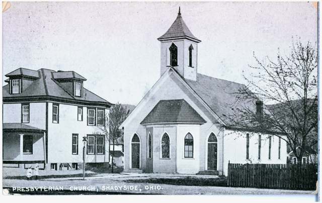
Photo: Columbus Metropolitan Library, via Digital Public Library of America / Ohio Digital Network, public domain · Wikimedia Commons
Local history sources: en.wikipedia.org · commons.wikimedia.org · archive.org
Water
Groundwater wells (2 wells) The water here
- Shadyside Public Water System100% of residentsGroundwater wells (2 wells)
Hospitals, fire stations and more
Inside Shadyside's boundary: 1 fire or EMS station, 3 public schools, 1 library, 1 police station and 3 spill cases. Press a pin or a name for its whole record and its source.
Fire and EMS stations (1)
-
OR and W Fire DistrictShadyside
- Address
- 4210 Central Avenue, Shadyside, OH 43947
- Coordinates
- 39.96996, -80.75133
USGS National Map structures (source) ↗ Street map and directions ↗
Source: USGS National Map structures (most Ohio records last updated 2019 to 2022), checked against the Columbus and Cleveland station lists. The department that answers a call is set by jurisdiction and mutual aid, not by distance.
Public schools (3)
-
Jefferson Ave Elementary School1.5 of 5 stars · Shadyside
- Address
- 4895 Jefferson Ave, Shadyside, OH 43947
- School district
- Shadyside Local School District
- Kind (NCES)
- Regular School
- Students, 2023-24
- 234
- Teachers (full-time equivalent)
- 12.5
- Report card, 2025-26
- 1.5 of 5 stars
- Ohio building IRN
- 017913
- NCES school ID
- 390460002400
NCES school record ↗ Ohio School Report Card ↗ Street map and directions ↗
-
Leona Ave Middle School3 of 5 stars · Shadyside
- Address
- 3795 Leona Ave, Shadyside, OH 43947
- School district
- Shadyside Local School District
- Kind (NCES)
- Regular School
- Students, 2023-24
- 184
- Teachers (full-time equivalent)
- 14
- Report card, 2025-26
- 3 of 5 stars
- Performance index
- 83.3%
- Ohio building IRN
- 020172
- NCES school ID
- 390460002401
NCES school record ↗ Ohio School Report Card ↗ Street map and directions ↗
-
Shadyside High School4 of 5 stars · Shadyside
- Address
- 3890 Lincoln Ave, Shadyside, OH 43947
- School district
- Shadyside Local School District
- Kind (NCES)
- Regular School
- Students, 2023-24
- 296
- Teachers (full-time equivalent)
- 18.2
- Report card, 2025-26
- 4 of 5 stars
- Performance index
- 83%
- Four-year graduation rate
- 97.8%
- Ohio building IRN
- 034090
- NCES school ID
- 390460002402
NCES school record ↗ Ohio School Report Card ↗ Street map and directions ↗
Source: NCES EDGE public school locations 2024-25 and Common Core of Data 2023-24 (type, students, teachers); Ohio School Report Cards 2025-26 (Department of Education and Workforce), matched by name within the district.
Public libraries (1)
-
Shadyside BranchBranch · Shadyside
- Address
- 4300 Central Ave, Shadyside, OH 43947
- What it is
- Branch
- Library system
- Belmont County District Library
- Open
- 2,236 hours a year, 52 weeks
- Building
- 7,400 sq ft
- System's visits, FY2024
- 74,932
- System's loans, FY2024
- 114,482
- People the system serves
- 33,295
- Phone
- (740) 676-0506
IMLS Public Libraries Survey (source) ↗ Street map and directions ↗
Source: IMLS Public Libraries Survey FY2024 (outlets and their systems). Any Ohio resident can get a free card at any Ohio public library.
Police stations (1)
-
Shadyside Police DepartmentShadyside
- Address
- 50 East 39th Street, Shadyside, OH 43947
- Coordinates
- 39.97161, -80.74828
USGS National Map structures (source) ↗ Street map and directions ↗
Source: USGS National Map structures, police stations, corrected and completed by hand (September 2026). The department that answers a call is set by jurisdiction, not by distance.
Spills reported since 2021 (3)
-
Fuel Diesel / Diesel Fuel (Vehicle On Or Off Road)2025-09-09 · Shadyside
- Reported
- 2025-09-09
- What spilled
- Fuel Diesel / Diesel Fuel (Vehicle On Or Off Road); Oil Motor / Lube Oil / Vehicle
- Where
- Shadyside, Belmont County
- Ohio EPA district office
- SEDO
- Ohio EPA case number
- 2509EPA0001523
Ohio EPA spill reports (source) ↗ Street map and directions ↗
-
Asbestos2025-09-07 · Shadyside
- Reported
- 2025-09-07
- What spilled
- Asbestos
- Where
- Shadyside, Belmont County
- Ohio EPA district office
- SEDO
- Ohio EPA case number
- 2509EPA0001510
Ohio EPA spill reports (source) ↗ Street map and directions ↗
-
Material Blue Reached water2025-09-02 · Shadyside
- Reported
- 2025-09-02
- What spilled
- Material Blue
- Reached a waterway
- 99 - Unnamed
- Where
- Shadyside, Belmont County
- Ohio EPA district office
- SEDO
- Ohio EPA case number
- 2509EPA0001477
Ohio EPA spill reports (source) ↗ Street map and directions ↗
Source: Ohio EPA emergency response spill reports, 2021 to September 2026, one point per case where Ohio EPA placed it. A report is what the caller or responder recorded; amounts are often blank or estimated.
Its ZIP codes
Each ZIP code that touches Shadyside, with the share of its residents who live here and the same headline figures as the ZIP page.
| ZIP | Share | Water | Radon | Home value | Schools | Flood |
|---|---|---|---|---|---|---|
| 43947 Shadyside | 68% | Groundwater wells (2 wells) | 3.2 pCi/L average radon | Median year built 1947 | Shadyside Local · 3.5 stars overall | 3.2% of residents in the 1% floodplain |
Local government
Who holds office in Shadyside, how its elections and ballot issues came out, and the state auditor's record.
Money issues on the ballot since 2015: 5 of 5 passed.
Ballot issues
| Date | Issue | For | Against | Result |
|---|---|---|---|---|
| 2020-11-03 | Issue: Shadyside Village 1.9 Mill Current Expenses Levy (1.9 mills) | 1,112 | 714 | Passed (60.9% for) |
| 2020-11-03 | Issue: Shadyside Village 2.5 Mills Current Expenses Levy (2.5 mills) | 1,048 | 763 | Passed (57.87% for) |
| 2019-11-05 | Issue: Shadyside Village - Current Expense - Renewal | 586 | 302 | Passed (65.99% for) |
| 2019-11-05 | Issue: Shadyside Village - Police - Additional | 531 | 360 | Passed (59.6% for) |
| 2018-11-06 | Issue: Shadyside Village - Current Expenses - Renewal | 812 | 581 | Passed (58.29% for) |
| 2017-11-07 | Issue: Shadyside Village Police - Renewal Levy | 695 | 293 | Passed (70.34% for) |
| 2015-11-03 | Issue: Village of Shadyside - Current Expenses (1.9 Mills) Renewal Levy (1.9 mills, renewal) | 704 | 418 | Passed (62.75% for) |
| 2015-11-03 | Issue: Village of Shadyside - Current Expenses (2.5 Mills) Renewal Levy (2.5 mills, renewal) | 676 | 450 | Passed (60.04% for) |
Elections for office
| Date | Office | Candidates and votes |
|---|---|---|
| 2021-11-02 | Village Council (unofficial count) | John Nick Ferrelli (REP) 541, 17.67%; Carol L. Givens 128, 4.18%; Robert Carl Gorrell (DEM) 531, 17.35%; Melanie L. Haswell (DEM) 479, 15.65%; Louis Michael Meintel (REP) 526, 17.18%; Kevin L. Tomlinson 215, 7.02%; Write-In: Timothy A. Merryman 361, 11.79%; Write-In: Brandon Parr 258, 8.43% |
| 2021-11-02 | Mayor (unofficial count) | Greg Patrick Givens 135, 15.96%; Robert Newhart 711, 84.04% |
| 2021-11-02 | Board of Public Affairs (unofficial count) | Write-In: Sue Ann Ferrelli 135, 62.79%; Write-In: David Gazdik 47, 21.86% |
| 2017-11-07 | Village Council | Tim Merryman (DEM) 760, 18.63%; Bob Bell 639, 15.66%; Robert C. Gorrell Sr. (DEM) 550, 13.48%; John N. Ferrelli (REP) 480, 11.76%; Sammy Carpino 377, 9.24%; Gary Rodgers 367, 9.0%; Richard L. Loew Jr. (DEM) 303, 7.43%; Kevin L. Tomlinson 252, 6.18%; Ronald R. Reger 183, 4.49%; Carol L. Gray 169, 4.14% |
| 2017-11-07 | Mayor | Robert Newhart (DEM) 800, 81.63%; Greg Patrick Givens 180, 18.37% |
| 2017-11-07 | Board of Public Affairs | Write-In: David Gazdik 6, 11.54%; Write-In: William Dean Smith 5, 9.62% |
Winners in bold. Results from the county board of elections' official canvass unless marked.
Auditor of State record
- No fiscal caution, watch or emergency on the Auditor of State's lists.
- Financial Audit, 2022 to 2023, released 2025-07-24
The county
Belmont County: 23 ZIP codes, 29 cities, villages and townships, 64,982 people.
Nearby places
Rain and snow
How much has actually fallen on Shadyside, day by day, from 1878 to now. Daily totals, not averages.
- rain, last 30 days
- 2.65 in
- 2026-09-30 to 2026-10-29
- rain so far in 2026
- 45.3 in
- 7.6 in above normal for the date
- snow so far in 2026
- 18.4 in
- a normal year brings 22.2 in
- a normal year
- 44.5 in
- average of 30 years, 1991-2020
| Month | Rain (in) | Snow (in) | Days counted |
|---|---|---|---|
| October 2026 | 2.65 | — | 29 |
| September 2026 | 4.39 | — | 30 |
| August 2026 | 6.66 | — | 31 |
| July 2026 | 4.92 | — | 31 |
| June 2026 | 5.32 | — | 30 |
| May 2026 | 5.99 | — | 31 |
| April 2026 | 5.44 | 0.0 | 30 |
| March 2026 | 6.38 | 3.1 | 31 |
| February 2026 | 1.50 | 2.3 | 28 |
| January 2026 | 2.05 | 12.9 | 31 |
| December 2025 | 2.17 | 10.5 | 31 |
| November 2025 | 2.39 | 0.0 | 30 |
| Wettest year | 2018 — 67.0 in |
|---|---|
| Driest year | 1930 — 24.5 in |
| Snowiest year | 1914 — 60.2 in |
| Wettest day on record | 18 September 2004 — 6.09 in |
| Heaviest snowfall in a day | 14 March 1993 — 17.62 in |
| Deepest snow on the ground | 29 November 1950 — 22.93 in |
Estimated, not measured. No rain gauge has ever stood inside Shadyside, so every figure here is worked out from the gauges around it - the nearest ones weighted most. Treat them as close estimates rather than readings.
51,991 days of records, 1878-02-01 to 2026-10-29. Source: NOAA NCEI GHCN-Daily, 3,240 gauges in and around Ohio. A day is "gauged" when a gauge standing inside the boundary reported it, and the value is the mean of those gauges. Otherwise it is interpolated by inverse distance from every gauge reporting within 50 miles. Nothing is carried forward, back-filled or smoothed. Against NOAA nClimDiv county monthly precipitation over 136,848 complete county-months (checked 2026-10-31): correlation 0.9515, median absolute difference 0.217 in a month. Built 2026-10-31 from the Cracked Buckeye precipitation archive. Snow is the softer number — snowfall is measured by hand with a ruler, no agency publishes a gridded county snowfall series, and blowing snow defeats every observer.
Environmental permits and filings
What Ohio EPA has on file for Shadyside: permits, inspections, violations, cleanups and the state loans behind sewer and water work. Every line links to the agency's own document.
- facilities and sites on file
- 11
- those placed on the map inside Shadyside
| Program | Facilities and sites |
|---|---|
| Hazardous waste | 5 |
| Air pollution | 1 |
| Brownfield | 1 |
| Contaminated-site cleanup | 1 |
| Public drinking water | 1 |
| State sewer loans | 1 |
| State water loans | 1 |
| Date | Facility or site | What |
|---|---|---|
| XTO ENERGY INC - WASSMANN UNIT | Air pollution inspection | |
| VILLAGE OF SHADYSIDE | Brownfield assessment | |
| SHADYSIDE PUBLIC WATER SYSTEM PWS | State water loans | |
| VILLAGE OF SHADYSIDE | Brownfield assessment | |
| VILLAGE OF SHADYSIDE | Brownfield assessment | |
| VILLAGE OF SHADYSIDE | Brownfield assessment | |
| SHADYSIDE PUBLIC WATER SYSTEM PWS | State water loans | |
| VILLAGE OF SHADYSIDE | Brownfield assessment | |
| VILLAGE OF SHADYSIDE | Brownfield assessment | |
| XTO ENERGY INC - WASSMANN UNIT | Air pollution inspection | |
| SHADYSIDE WTP LABORATORY | Public drinking water | |
| VILLAGE OF SHADYSIDE | Brownfield assessment | |
| ASCENT RESOURCES - UTICA LLC - WASSMANN | Air pollution permit | |
| VILLAGE OF SHADYSIDE | Brownfield assessment | |
| XTO ENERGY INC - WASSMANN UNIT | Air pollution permit | |
| XTO ENERGY INC - WASSMANN UNIT | Air pollution inspection | |
| XTO ENERGY INC - WASSMANN UNIT | Air pollution notice of violation |
Source: Ohio EPA eDocument portal (edocpub.epa.ohio.gov), indexed 2026-10-14. Facilities are placed on the map from Ohio EPA's own map layers, EPA's Facility Registry, coordinates written in the filings, or a geocoded street address. A permit filed under a private person's name (most are household septic systems) is counted but never named, placed or linked; licenses for individual workers and open-burning notices are left out entirely.
Quick answers
What county is Shadyside, Ohio in?
Shadyside is a village in Belmont County, Ohio, with 3,399 residents.
When was Shadyside, Ohio founded?
Shadyside was laid out 1901. Source
How did Shadyside, Ohio get its name?
Named for a local farm known for its tree-lined shade. Source
What ZIP code is Shadyside, Ohio?
Most of Shadyside is in ZIP code 43947.
Where does Shadyside, Ohio get its water?
The main water source for Shadyside (Shadyside Public Water System): Groundwater wells (2 wells).
Cite this page
Cite this page as:
Cracked Buckeye, "Shadyside, Belmont County", https://crackedbuckeye.com/place/shadyside/, built 2026-10-31, accessed [date].
How to cite · Report a correction · Built 2026-10-31
