How Lockbourne began
Lockbourne is a village in southern Franklin County, on the Scioto River just above its confluence with Big Walnut (Gahanna) Creek. Colonel James Kilbourne, acting as agent for landowners Joel Buttles, Demas Adams and others, platted the village in the fall of 1831 at the junction of the Ohio and Erie Canal and the newly completed Columbus Feeder, and it took its name from the canal locks built at the site combined with the last syllable of Kilbourne's own surname. Canal commerce built the town's brief prosperity — a distillery, mills, a hotel and taverns clustered around Lock 30 — before the canal itself declined and railroads took its trade; by 1880 the county history already called Lockbourne 'not thriving.' Today it is a village of about 240 people, still built around its old canal-town grid, best known locally for its surviving locks and for lending its name to the World War II airfield next door that grew into Rickenbacker International Airport.
Platted 1831, by Colonel James Kilbourne (1770-1850), acting as agent for landowners Joel Buttles, Demas Adams and others.
Where the name comes from
The 1880 county history states that 'the first syllable of the name of the village is derived from the circumstance of a number of locks in the canal at that point — to which the proprietor added the last syllable of his own name,' meaning Colonel James Kilbourne, who platted the town in 1831; the on-site state historical marker agrees. A mid-twentieth-century place-name study in the Ohio Archaeological and Historical Quarterly complicates this popular story: it notes the village was first recorded simply as 'Eight Locks,' and observes that '-bourn' is the ordinary English place-name suffix for a stream, suggesting to its author that someone unfamiliar with the suffix may have simply noticed the resemblance to Kilbourne's name and built the popular explanation around that coincidence after the fact, rather than the name being intentionally coined from it.
Before the town
Hamilton Township, in which Lockbourne sits, 'is within the, so-called, Congress lands,' bounded on the west by the Scioto River, according to the 1880 county history. These lands were opened to American settlement by the Treaty of Greenville (August 3, 1795), in which the Wyandot, Lenape (Delaware), Shawnee, Ottawa, Chippewa, Potawatomi, Miami and other nations ceded roughly two-thirds of the Ohio Country to the United States after the Northwest Indian War; the fuller treaty and nations picture for the county is given in the county file. Lockbourne itself sits where Big Walnut Creek meets the Scioto, and both names are Native in origin. Henry Howe's 1889 history records that 'Scioto was named by the Wyandott who formerly resided by it... The Wyandotts pronounced the word Scionto, signification unknown'; a later authority, Charles Hanna's The Wilderness Trail (1911), guesses instead that it is 'probably a Wyandot word for deer.' Big Walnut Creek was itself called the Gahanna River into the 1830s, and the federal Geographic Names Information System records two further, older names for it as well — 'Whingwy Mahoni Sepung' and 'Menkwi Mhoani Siipunk' — evidently Native-language forms that no source consulted here translates. No named historic-era Wyandot, Shawnee or Delaware village, camp or trail is recorded specifically at the Lockbourne site in the sources checked for this file. What survives instead is a scatter of earlier mounds on the high ground around the village: an 1888 letter from Columbus correspondent Prosper M. Wetmore to the Ohio Archaeological and Historical Quarterly, cataloguing Franklin County's earthworks, records a mound on the E. J. Young farm about a mile northeast of Lockbourne that Wetmore admitted he had 'never visited,' another atop Baker's Hill at the crossing of the Lockbourne and Groveport pikes, and three more mounds on the farm of M. Cloud 'overlooking the bottom lands of the Scioto and Gahanna rivers' — the same high ground the village itself looks out from. Wetmore assigned none of them to a known culture; the round-and-oblong mound pattern matches the Adena and Hopewell mound-building traditions recorded elsewhere along the Scioto valley, including other, separately documented mounds in Hamilton Township (see the township file, T33026-FRA).
Nations recorded here: Wyandot, Lenape (Delaware), Shawnee, Miami, Ottawa, Adena culture, Hopewell culture.
- E. J. Young farm mound (mound) — about one mile northeast of Lockbourne, Hamilton Township, unknown (pre-contact) (resources.ohiohistory.org)
- Baker's Hill mound (mound) — at the intersection of the Lockbourne and Groveport pikes, Hamilton Township, unknown (pre-contact) (resources.ohiohistory.org)
- M. Cloud farm mounds (mound) — on high ground overlooking the bottom lands of the Scioto and Gahanna (Big Walnut) rivers, Hamilton Township, unknown (pre-contact) (resources.ohiohistory.org)
Timeline
- — A store serving the Ohio and Erie Canal's construction crews opens at the future townsite, about three years before the village is platted.
- — Colonel James Kilbourne, acting as agent for Joel Buttles, Demas Adams and other landowners, plats Lockbourne in the fall at the junction of the Ohio and Erie Canal and the newly completed Columbus Feeder.
- — Lockbourne's post office opens with Nathan G. Smith as the first postmaster.
- — Daniel Kellogg establishes the frame distillery at the east end of town that later becomes the Monypenny distillery, Lockbourne's largest employer.
- — Lockbourne's Methodist congregation raises its first church building; the village's own history gives 1848, while the 1880 county history dates the brick Methodist Episcopal church to 1850.
- — Lockbourne Lodge No. 232, Free and Accepted Masons, organizes on November 18, 1852, with Dr. A. N. Boalse as first Worshipful Master, and receives its charter on October 20, 1853.
- — Howlett's Mill, built in 1842 as a canal warehouse at the west end of Commerce Street, is converted into a gristmill.
- — St. Matthew's Evangelical Lutheran Church is erected in Lockbourne at a cost of just over three thousand dollars.
- — The county history counts about 300 people in Lockbourne, with two stores, two churches, a post office, a schoolhouse, one distillery and two saloons, and calls the village 'not thriving.'
- — The Christian S. Herr House, a Queen Anne farmhouse, is built north of the village at what is now 1451 Rathmell Road; it is listed on the National Register of Historic Places in 1982.
- — The Lockbourne United Methodist Church building standing today at 1260 Vause Street is built.
- — Lockbourne Army Airfield opens just north of the village and takes its name; the Air Force renames it Rickenbacker in 1974, and the site is now split between the Air National Guard base and Rickenbacker International Airport.
Stories
Eight Locks, Before It Was Lockbourne
When Colonel James Kilbourne laid out the village in the fall of 1831, at the junction where the new Ohio and Erie Canal met the Columbus Feeder, it was first recorded under a plainer name: Eight Locks, for the flight of canal locks built at the site to carry boats down toward the Scioto. The name Lockbourne that stuck combines that same word with the last syllable of Kilbourne's own surname, and every popular local history since the 1880 county history has told it that way. A twentieth-century place-name scholar, writing in the Ohio Archaeological and Historical Quarterly, was less sure: he pointed out that '-bourn' is simply the ordinary English suffix meaning stream, and guessed that someone unfamiliar with the suffix noticed how closely it echoed Kilbourne's name and built the tidy explanation around the coincidence afterward. Whichever telling is right, the name has outlasted the eight locks themselves — only a handful survive today, numbered 26, 27, 29 and 30, the last of them still watering the walking trail through Lock Meadows Park.
The Monypenny Distillery
Daniel Kellogg built a frame distillery at the east end of Lockbourne in 1839; by the time it passed to William Monypenny it was the village's largest industry, turning out 100 barrels of whiskey a day and shipping much of it out on the canal in two boats the firm owned outright, the Magnolia and the Cruiser. The operation was large enough to need its own cooper shop for barrels, a whiskey warehouse, several corn cribs, and a hog lot that could hold up to a thousand animals fattened on the spent mash. Fire destroyed the original building in 1853; A. H. Elliott rebuilt it in brick, and the distillery kept running for decades even as the canal that carried its product began losing business to the railroads. Nothing of it survives above ground today — the grade the Chesapeake and Ohio Railroad later laid through town ran straight across both the old distillery site and the canal's north basin beside it.
The Last Canal Boat Captain, Briefly of Lockbourne
Pearl R. Nye was born in 1872 into a family that made its living running boats on the Ohio and Erie Canal, and for a stretch of his life the family's work brought them to live in Lockbourne. He spent decades on the water as a working boatman, and in his later years he did something almost no other canaller thought to do: he wrote down and sang the songs, poems and stories of the canal trade before they could disappear along with it. He became known as a folklorist as much as a boatman, and his collection of canal-era songs, poems and recordings — memory of a working world that once passed straight through Lockbourne's own locks — is preserved today by the Library of Congress and the Ohio History Connection. A state historical marker at Decker and Commerce Streets in the village now carries his name alongside the town's own canal history.
The Mounds Around the Locks
Long before Colonel Kilbourne platted his canal town, the high ground above the Scioto and Big Walnut confluence carried the mounds of an earlier people. An 1888 catalogue of Franklin County's earthworks, compiled by Columbus correspondent Prosper M. Wetmore for the Ohio Archaeological and Historical Quarterly, records a mound on the E. J. Young farm about a mile northeast of Lockbourne that Wetmore admitted he had 'never visited'; another on Baker's Hill, at the crossing of the Lockbourne and Groveport pikes, seventy-five feet across and fifteen feet high; and three more mounds on the farm of M. Cloud, on the high ground 'overlooking the bottom lands of the Scioto and Gahanna rivers' — the same rise the village itself looks out from. None were excavated for the catalogue, and Wetmore recorded no name for the people who built them, only that they were already old, unexplained landmarks to the farmers whose fields surrounded them. The pattern of round and oblong earthen mounds matches the Adena and Hopewell mound-building traditions recorded elsewhere along the Scioto valley, though no source found here assigns these particular mounds to either culture by name.
A Village That Named an Airfield
When the Army Air Corps opened a new training field just north of the village in September 1942, it took the plainest name available: Lockbourne Army Airfield, after the small canal town beside it. The base outlived its wartime mission by decades, and in 1974 the Air Force renamed it Rickenbacker, honoring Columbus-born flying ace Eddie Rickenbacker; the site today is split between the Rickenbacker Air National Guard Base and Rickenbacker International Airport. Lockbourne itself never grew to match its much larger neighbor — the village's population is still counted in the low hundreds — but it has not let go of the connection: the village government maintains a Lockbourne/Rickenbacker Air Force Base Memorial Wall, selling engraved bricks to keep both the base's history and the village's own name tied to it in public view. The memorial sits in a village that is otherwise easy to miss from the runways next door, where Rickenbacker's cargo jets and Air National Guard tankers now dwarf the canal-era grid of streets that gave the base its original name.
Photographs
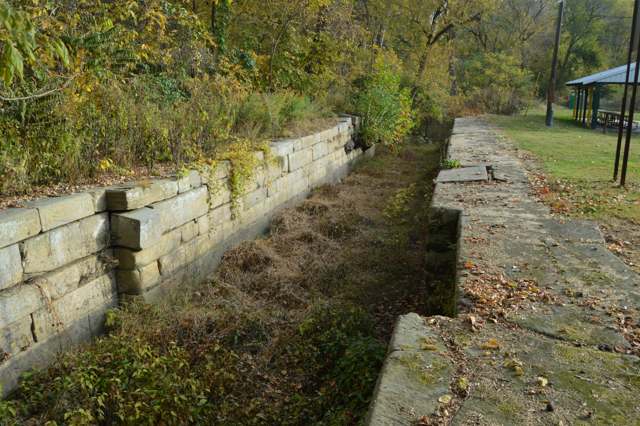
Photo: Nyttend, public domain · Wikimedia Commons
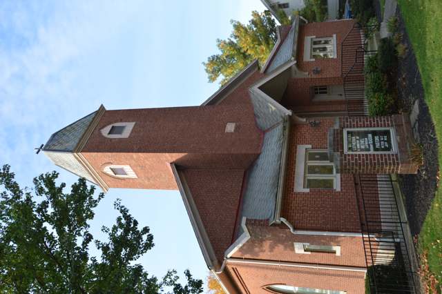
Photo: Nyttend, public domain · Wikimedia Commons
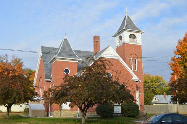
Photo: Nyttend, public domain · Wikimedia Commons
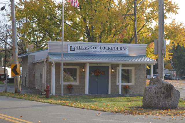
Photo: Nyttend, public domain · Wikimedia Commons
Local history sources: en.wikipedia.org · remarkableohio.org · web.archive.org · lockbourneohio.us · lockbourneohio.us · ohioexploration.com · ohiogenealogyexpress.com · genealogybug.net · npgallery.nps.gov · resources.ohiohistory.org · resources.ohiohistory.org · en.wikipedia.org · en.wikipedia.org · web.archive.org · en.wikipedia.org · commons.wikimedia.org · commons.wikimedia.org · commons.wikimedia.org · commons.wikimedia.org
Water
South Well Field wells in Scioto valley sand and gravel, off Parsons Ave near Shadeville and Lockbourne The water here
- Columbus Public Water System82% of residentsScioto River (Griggs & O'Shaughnessy), Hoover Reservoir on Big Walnut Ck, plus wells
- Caravan Village MHP14% of residentsGroundwater wells (2 wells)
- Lockbourne Village3% of residentsScioto River (Griggs & O'Shaughnessy), Hoover Reservoir on Big Walnut Ck, plus wells
- Obetz Satellite 61% of residentsScioto River (Griggs & O'Shaughnessy), Hoover Reservoir on Big Walnut Ck, plus wells
- Obetz Village1% of residentsGroundwater wells (2 wells)
Its ZIP codes
Each ZIP code that touches Lockbourne, with the share of its residents who live here and the same headline figures as the ZIP page.
| ZIP | Share | Water | Radon | Home value | Schools | Flood |
|---|---|---|---|---|---|---|
| 43137 Harrison Township and Lockbourne | 9% | South Well Field wells in Scioto valley sand and gravel, off Parsons Ave near Shadeville and Lockbourne | 9.5 pCi/L average radon | Median year built 1978 | Teays Valley Local · 4 stars overall | 9.3% of residents in the 1% floodplain |
The county
Franklin County: 45 ZIP codes, 42 cities, villages and townships, 1,356,733 people.
Nearby places
Cite this page
Cite this page as:
Cracked Buckeye (Open Shower Co), "Lockbourne, Franklin County", https://crackedbuckeye.com/place/lockbourne/, built 2026-09-16, accessed [date].
Machine-readable: /api/place/lockbourne.json (open JSON, CC BY 4.0 for the compilation; the underlying records keep their own terms) · How to cite · Report a correction · Built 2026-09-16