Local events in Ashville
6 events in the next 90 days from 3 public calendars. All local events in Ashville
Checked October 20; the events page is refreshed daily.
Deep dives about Ashville
Long reads built from maps, newspapers and public records. All deep dives
How Ashville began
Ashville grew up in Harrison Township on land Richard Staige Sr. settled about 1808; after his sons built distilleries there, Mahlon Ashbrook bought the operation around 1837 and built it into a distillery, gristmill and store that gave the place its name. The business collapsed in the 1850s and the settlement languished until the Scioto Valley Railroad reached it in 1874, after which Ashville incorporated in 1882 and grew into a shipping point for livestock, grain and, after 1899, canned goods. The village is now known for an unlikely piece of technology: a hand-built 1932 traffic signal that ran continuously for fifty years and is recognized by Guinness World Records as the world's oldest functional traffic light, on display today at Ohio's Small Town Museum. A cluster of Hopewell-era burial mounds, the Snake Den Mounds, stands a few miles away on a hilltop near the village.
Settled 1808 (Richard Staige Sr., from Virginia), incorporated spring of 1882, by Mahlon Ashbrook, who bought Richard Staige Jr.'s distillery about 1837 and built up the settlement's trade.
Where the name comes from
Ashville's name comes from Mahlon Ashbrook, who purchased Richard Staige Jr.'s small distillery about 1837, enlarged it, and added a gristmill on Walnut Creek and a large store, becoming the settlement's principal businessman. Wikipedia's article states the settlement was first known as 'Ashbrook' before the name shortened to Ashville, though neither of the two county histories consulted (1880 and 1906) uses the name Ashbrook for the place itself; both refer to it as Ashville throughout, so the intermediate name could not be independently confirmed.
Before the town
The best-documented Native American site near Ashville is the Snake Den Mounds, a cluster of earthworks on a hilltop a few miles from the village (administratively in neighboring Walnut Township). Rows of pits dug across the hilltop date to about 900 BCE by radiocarbon analysis of pit charcoal; roughly 1,000 years later, about 2,000 years ago, people built burial and cremation mounds there together with a ditch-and-embankment enclosure, work attributed on the basis of recovered artifacts to the Hopewell or a related Adena-Hopewell culture. The Ohio State Archaeological and Historical Society excavated the site in 1897, recovering eight human skeletons, cremated remains in a stone urn, and grave goods including paint grinders, hammerstones, pestles and a stone container holding five silver nuggets; a magnetometer survey begun in 2007 has since mapped the site without further disturbing the remaining burials. Ashville's own Wikipedia article also states that Hopewell people inhabited the area 'long before' European settlement and that the Pekowi band of the Shawnee -- the band for which Pickaway County is named -- lived in the vicinity through much of the 18th century, but the sources cited for that claim are a general county government web page and a general encyclopedia article on the Shawnee nation as a whole, not documentation specific to the Ashville site, so it is reported here with that caveat rather than as an established site-specific fact. No source found records a named village, trail, or treaty boundary within the village's own limits.
Nations recorded here: Shawnee (Pekowi band), Hopewell culture, Adena culture.
- Snake Den Mounds (mound) — hilltop near Ashville, in neighboring Walnut Township, Pickaway County, pit features c. 900 BCE; burial/cremation mounds and enclosure roughly 2,000 years old, attributed to Hopewell/Adena-related culture (farmanddairy.com)
Timeline
- — Richard Staige Sr., from Virginia by way of Edinburgh, Scotland, settles the land that becomes Ashville.
- — Richard Staige Sr. dies; his sons Richard Jr. and William each build distilleries on the family land.
- — On July 6, Richard Staige Jr. purchases 77.57 acres from the Chillicothe Land Office.
- — Richard Staige Jr. sells his distillery to Mahlon Ashbrook, who expands the business.
- — Mahlon Ashbrook builds a gristmill on Walnut Creek and operates a large store, making him one of the settlement's wealthiest men before he later fails in business.
- — Ashbrook's store closes and he leaves for northern Ohio and then Missouri; the distillery runs under other operators for a few more years before it too closes, and little business is done in Ashville for the next two decades.
- — Construction of the Scioto Valley Railroad through Harrison Township, under engineer Isham Randolph, revives the settlement's economy.
- — A post office is reestablished at Ashville and the railroad locates its depot there.
- — Ashville incorporates as a village in the spring, nearly seventy years after Richard Staige's first settlement.
- — The Ohio State Archaeological and Historical Society excavates the Snake Den Mounds near Ashville, recovering eight skeletons, cremated remains, and grave goods including five silver nuggets in a stone container.
- — The Scioto Valley Canning Factory is built, employing up to 540 workers and producing more than 200,000 cans a day at its peak.
- — The Scioto Valley Traction Company opens an electric interurban railway connecting Columbus and Chillicothe through Ashville; it runs until September 1930.
- — Resident Teddy (T. A.) Boor builds a distinctive silver, egg-shaped traffic signal for Ashville's main intersection.
- — Ohio's Small Town Museum opens in a former silent-film theater in Ashville.
- — Boor's traffic signal is retired after fifty years of continuous service, replaced because color-blind drivers had trouble reading it; Guinness World Records later recognizes it as the world's oldest functional traffic light.
Stories
The World's Oldest Traffic Light
In 1932, Ashville resident Teddy Boor built a traffic signal unlike any other: a silver, egg-shaped device with four faces, each lit in turn by a single rotating red-and-green lamp inside. Installed at Ashville's main intersection, it directed cross-town traffic continuously for the next fifty years. It was finally retired in 1982, not because it broke down but because color-blind drivers had trouble telling its lamp colors apart, a problem newer signals had already solved. Guinness World Records has since recognized it as the world's oldest functional traffic light. It did not go to a scrapyard; it went a few blocks to Ohio's Small Town Museum, opened in 1978 in a former silent-film theater, where it still lights up red and green for visitors today.
Boom, Bust, and the Railroad
Ashville's first business was liquor. Richard Staige's sons built distilleries on the family land soon after his death in 1811, and when Mahlon Ashbrook bought one out about 1837, he built it into a genuine local economy, adding a Walnut Creek gristmill and a large general store. For a time he was reputed a wealthy man. Then he failed. His store closed about 1855, he left the state for Missouri by way of northern Ohio, and though other men kept the distillery running a few more years, business in Ashville nearly disappeared for the next two decades. What revived it was not a new industry but a new railroad: when the Scioto Valley line was built through Harrison Township in 1874, a depot and reestablished post office followed within a year, and the trade that had died with Ashbrook's failure came back to stay.
Burial Mounds on the Hilltop
A few miles from Ashville, a low hilltop holds a much older story than the village's own. About 900 BCE, people dug rows of pits across the hilltop for reasons no longer known. Roughly a thousand years later, about two thousand years ago, a different group of people -- probably connected to the Hopewell tradition of the Scioto valley -- carried soil and stone up the slope to raise burial and cremation mounds there, and dug a ditch-and-embankment enclosure around them. When the Ohio State Archaeological and Historical Society excavated the site in 1897, they found eight human skeletons, cremated remains sealed in a stone urn, and grave goods that included paint grinders, hammerstones, pestles, and, in one stone container, five silver nuggets. The site, now called the Snake Den Mounds for the snakes once said to hibernate there, is today held by a preservation society that uses non-invasive magnetometer surveys, begun in 2007, to keep learning about it without disturbing what remains.
Photographs
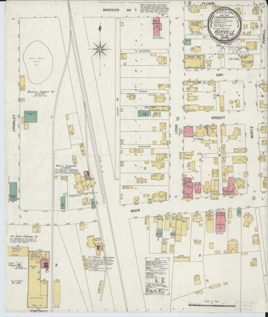
Photo: Sanborn Map Company, via Library of Congress and Wikimedia Commons, public domain · Wikimedia Commons
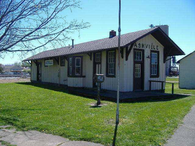
Photo: Aesopposea, via Wikimedia Commons, CC BY-SA 3.0 · Wikimedia Commons
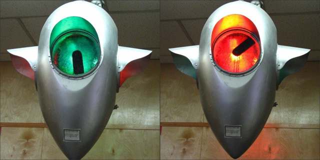
Photo: Don O'Brien, via Wikimedia Commons, CC BY 2.0 · Wikimedia Commons
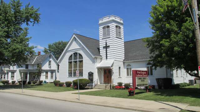
Photo: Aesopposea, via Wikimedia Commons, CC BY-SA 3.0 · Wikimedia Commons
Local history sources: en.wikipedia.org · archive.org · archive.org · en.wikipedia.org · guinnessworldrecords.com · farmanddairy.com · snake-den-mounds.org · pickawaylib.org · commons.wikimedia.org · commons.wikimedia.org · commons.wikimedia.org · commons.wikimedia.org
Historic places
1 place in Ashville on the National Register of Historic Places. Press a pin or a name for its whole record.
-
Ashville DepotBuilding · Ashville · listed 1980
- Address
- Madison and Cromley Sts.
- Where
- Ashville, Pickaway County · ZIP 43103
- What it is
- Building
- Listed on the National Register
- 1980
- NRIS reference number
- 80003209
- Coordinates
- 39.71502, -82.95536
National Register file (NPS) ↗ Search Wikipedia ↗ Street map and directions ↗ On the Cracked Buckeye map
Source: National Park Service, National Register of Historic Places point file. The listing year is shown where NPS's certification date agrees with the listing's reference number. Listing recognizes significance; it does not restrict a private owner.
Water
Mostly private wells The water here
- Ashville Village69% of residentsGroundwater wells (2 wells)
- South Bloomfield Village18% of residentsGroundwater wells (3 wells)
- Columbus Public Water System13% of residentsScioto River (Griggs & O'Shaughnessy), Hoover Reservoir on Big Walnut Ck, plus wells
- Caravan Village MHP0% of residentsGroundwater wells (2 wells)
- Commercial Point Village0% of residentsGroundwater wells (6 wells)
- Lockbourne Village0% of residentsScioto River (Griggs & O'Shaughnessy), Hoover Reservoir on Big Walnut Ck, plus wells
- Obetz Satellite 60% of residentsScioto River (Griggs & O'Shaughnessy), Hoover Reservoir on Big Walnut Ck, plus wells
- Obetz Village0% of residentsGroundwater wells (2 wells)
Hospitals, fire stations and more
Inside Ashville's boundary: 1 fire or EMS station, 4 public schools, 1 library, 1 museum, 1 police station, 1 public charging site and 3 spill cases. Press a pin or a name for its whole record and its source.
Fire and EMS stations (1)
-
Harrison Township Fire DepartmentAshville
- Address
- 3625 State Highway 752, Ashville, OH 43103
- Coordinates
- 39.72311, -82.95068
USGS National Map structures (source) ↗ Street map and directions ↗
Source: USGS National Map structures (most Ohio records last updated 2019 to 2022), checked against the Columbus and Cleveland station lists. The department that answers a call is set by jurisdiction and mutual aid, not by distance.
Public schools (4)
-
Ashville Elementary School4.5 of 5 stars · Ashville
- Address
- 90 Walnut St, Ashville, OH 43103
- School district
- Teays Valley Local School District
- Kind (NCES)
- Regular School
- Students, 2023-24
- 399
- Teachers (full-time equivalent)
- 29.25
- Report card, 2025-26
- 4.5 of 5 stars
- Performance index
- 88.7%
- Ohio building IRN
- 001131
- NCES school ID
- 390490903488
NCES school record ↗ Ohio School Report Card ↗ Street map and directions ↗
-
Teays Valley Digital Academy1.5 of 5 stars · Ashville
- Address
- 383 Circleville Ave, Ashville, OH 43103
- School district
- Teays Valley Local School District
- Kind (NCES)
- Regular School
- Students, 2023-24
- 71
- Report card, 2025-26
- 1.5 of 5 stars
- Performance index
- 38.8%
- Four-year graduation rate
- 75%
- Ohio building IRN
- 019829
- NCES school ID
- 390490910839
NCES school record ↗ Ohio School Report Card ↗ Street map and directions ↗
-
Teays Valley East Middle School4 of 5 stars · Ashville
- Address
- 655 Viking Way, Ashville, OH 43103
- School district
- Teays Valley Local School District
- Kind (NCES)
- Regular School
- Students, 2023-24
- 468
- Teachers (full-time equivalent)
- 29.83
- Report card, 2025-26
- 4 of 5 stars
- Performance index
- 80.7%
- Ohio building IRN
- 064188
- NCES school ID
- 390490903491
NCES school record ↗ Ohio School Report Card ↗ Street map and directions ↗
-
Teays Valley High School3.5 of 5 stars · Ashville
- Address
- 3887 State Route 752, Ashville, OH 43103
- School district
- Teays Valley Local School District
- Kind (NCES)
- Regular School
- Students, 2023-24
- 1,269
- Teachers (full-time equivalent)
- 71.34
- Report card, 2025-26
- 3.5 of 5 stars
- Performance index
- 82.6%
- Four-year graduation rate
- 95.4%
- Ohio building IRN
- 036962
- NCES school ID
- 390490903490
NCES school record ↗ Ohio School Report Card ↗ Street map and directions ↗
Source: NCES EDGE public school locations 2024-25 and Common Core of Data 2023-24 (type, students, teachers); Ohio School Report Cards 2025-26 (Department of Education and Workforce), matched by name within the district.
Public libraries (1)
-
Floyd E. Younkin BranchBranch · Ashville
- Address
- 51 Long St, Ashville, OH 43103
- What it is
- Branch
- Library system
- Pickaway Cnty District Public Library
- Open
- 2,392 hours a year, 52 weeks
- Building
- 5,000 sq ft
- System's visits, FY2024
- 100,100
- System's loans, FY2024
- 317,445
- People the system serves
- 58,539
- Phone
- (740) 983-8856
IMLS Public Libraries Survey (source) ↗ Street map and directions ↗
Source: IMLS Public Libraries Survey FY2024 (outlets and their systems). Any Ohio resident can get a free card at any Ohio public library.
Museums, historical societies, gardens and zoos (1)
-
Ashville Area Heritage SocietyHistorical society · Ashville
- What it is
- Historical society
- City
- Ashville
- Coordinates
- 39.71361, -82.95358
Search Wikipedia ↗ IMLS Museum Data Files (source) ↗ Street map and directions ↗
The museum list is IMLS's 2018 file; a museum may have closed or moved since.
Source: IMLS Museum Data Files, 2018.
Police stations (1)
-
Ashville Police DepartmentAshville
- Address
- 91 West Main Street, Ashville, OH 43103
- Coordinates
- 39.71288, -82.95626
USGS National Map structures (source) ↗ Street map and directions ↗
Source: USGS National Map structures, police stations, corrected and completed by hand (September 2026). The department that answers a call is set by jurisdiction, not by distance.
Public EV charging (1)
-
Distillery III, LLC4 Level 2 · Ashville
- Address
- 1812 Bourbon Street, Ashville, OH 43103
- Ports
- 4 Level 2
- Plugs
- J1772
- Network
- Blink Network
- Hours
- 24 hours daily
- Phone
- 888-998-2546
Station Locator (NREL) ↗ Alternative Fuels Data Center (source) ↗ Street map and directions ↗
Source: NREL Alternative Fuels Data Center station list (May 2026), public and open stations, the posts at one address counted as one site.
Spills reported since 2021 (3)
-
Sewage Sludge / Biosolids2024-01-15 · Ashville
- Reported
- 2024-01-15
- What spilled
- Sewage Sludge / Biosolids
- Where
- Ashville, Pickaway County
- Ohio EPA district office
- CDO
- Ohio EPA case number
- 2401EPA0000083
Ohio EPA spill reports (source) ↗ Street map and directions ↗
-
Material White2022-01-18 · Ashville
- Reported
- 2022-01-18
- What spilled
- Material White
- Where
- Ashville, Pickaway County
- Ohio EPA district office
- CDO
- Ohio EPA case number
- 2301EPA0000092
Ohio EPA spill reports (source) ↗ Street map and directions ↗
-
Sewage Human2021-11-29 · Ashville
- Reported
- 2021-11-29
- What spilled
- Sewage Human
- Where
- Ashville, Pickaway County
- Ohio EPA district office
- CDO
- Ohio EPA case number
- 2111EPA0001788
Ohio EPA spill reports (source) ↗ Street map and directions ↗
Source: Ohio EPA emergency response spill reports, 2021 to September 2026, one point per case where Ohio EPA placed it. A report is what the caller or responder recorded; amounts are often blank or estimated.
Its ZIP codes
Each ZIP code that touches Ashville, with the share of its residents who live here and the same headline figures as the ZIP page.
| ZIP | Share | Water | Radon | Home value | Schools | Flood |
|---|---|---|---|---|---|---|
| 43103 Ashville | 37% | Mostly private wells | 8.3 pCi/L average radon | Median year built 1995 | Teays Valley Local · 4 stars overall | 9.9% of residents in the 1% floodplain |
| 43137 Harrison Township and Lockbourne | 1% | South Well Field wells in Scioto valley sand and gravel, off Parsons Ave near Shadeville and Lockbourne | 9.5 pCi/L average radon | Median year built 1978 | Teays Valley Local · 4 stars overall | 9.3% of residents in the 1% floodplain |
Local government
Who holds office in Ashville, how its elections and ballot issues came out, and the state auditor's record.
Elections for office
| Date | Office | Candidates and votes |
|---|---|---|
| 2023-11-07 | Member of Council | Roger L. Clark 644, 30.61%; Colton Henson 915, 43.49%; Mark Stewart 545, 25.9% |
| 2023-11-07 | Mayor | Nelson Embrey 360, 27.99%; Steve Welsh 926, 72.01% |
| 2017-11-07 | Member of Council | y S. Loveless 282, 34.99%; dley Lutz 276, 34.24%; Tracie N. Sorvillo 248, 30.77% |
| 2017-11-07 | Member of Council | Randy S. Loveless 282, 34.99%; Bradley Lutz 276, 34.24%; Tracie N. Sorvillo 248, 30.77% |
| 2015-11-03 | Mayor | Brian M. Garvine 350, 38.63%; Charles K. Wise 556, 61.37% |
Winners in bold. Results from the county board of elections' official canvass unless marked.
The county
Pickaway County: 8 ZIP codes, 22 cities, villages and townships, 56,176 people.
Nearby places
Rain and snow
How much has actually fallen on Ashville, day by day, from 1893 to now. Daily totals, not averages.
- rain, last 30 days
- 0.83 in
- 2026-09-30 to 2026-10-29
- rain so far in 2026
- 47.1 in
- 10.9 in above normal for the date
- snow so far in 2026
- 17.9 in
- a normal year brings 16.2 in
- a normal year
- 42.5 in
- average of 30 years, 1991-2020
| Month | Rain (in) | Snow (in) | Days counted |
|---|---|---|---|
| October 2026 | 0.83 | — | 29 |
| September 2026 | 7.70 | — | 30 |
| August 2026 | 9.46 | — | 31 |
| July 2026 | 5.70 | — | 31 |
| June 2026 | 3.14 | — | 30 |
| May 2026 | 6.30 | — | 31 |
| April 2026 | 3.51 | — | 30 |
| March 2026 | 7.06 | 1.4 | 31 |
| February 2026 | 1.92 | 4.3 | 28 |
| January 2026 | 1.48 | 12.2 | 31 |
| December 2025 | 2.26 | 10.3 | 31 |
| November 2025 | 2.44 | 1.0 | 30 |
| Wettest year | 2011 — 59.7 in |
|---|---|
| Driest year | 1930 — 24.3 in |
| Snowiest year | 1910 — 45.4 in |
| Wettest day on record | 14 September 1979 — 4.33 in |
| Heaviest snowfall in a day | 17 February 1910 — 11.83 in |
| Deepest snow on the ground | 29 November 1950 — 18.34 in |
Estimated, not measured. No rain gauge has ever stood inside Ashville, so every figure here is worked out from the gauges around it - the nearest ones weighted most. Treat them as close estimates rather than readings.
48,313 days of records, 1893-01-01 to 2026-10-29. Source: NOAA NCEI GHCN-Daily, 3,240 gauges in and around Ohio. A day is "gauged" when a gauge standing inside the boundary reported it, and the value is the mean of those gauges. Otherwise it is interpolated by inverse distance from every gauge reporting within 50 miles. Nothing is carried forward, back-filled or smoothed. Against NOAA nClimDiv county monthly precipitation over 136,848 complete county-months (checked 2026-10-31): correlation 0.9515, median absolute difference 0.217 in a month. Built 2026-10-31 from the Cracked Buckeye precipitation archive. Snow is the softer number — snowfall is measured by hand with a ruler, no agency publishes a gridded county snowfall series, and blowing snow defeats every observer.
Environmental permits and filings
What Ohio EPA has on file for Ashville: permits, inspections, violations, cleanups and the state loans behind sewer and water work. Every line links to the agency's own document.
- facilities and sites on file
- 35
- those placed on the map inside Ashville
| Program | Facilities and sites |
|---|---|
| Wastewater and stormwater discharge | 16 |
| Site assessment | 4 |
| State sewer loans | 4 |
| Contaminated-site cleanup | 2 |
| Sewer and water-line construction | 2 |
| Wetland and stream fill | 2 |
| Air pollution | 1 |
| Hazardous waste | 1 |
| Public drinking water | 1 |
| Source-water protection | 1 |
| State water loans | 1 |
| Date | Facility or site | What |
|---|---|---|
| ASHVILLE GRAIN CO | Air pollution report | |
| ASHVILLE VILLAGE WRRF | Wastewater and stormwater discharge report | |
| ASHVILLE VILLAGE WRRF | Wastewater and stormwater discharge report | |
| ASHVILLE VILLAGE PWS | Public drinking water compliance letter | |
| ASHVILLE VILLAGE PWS | Public drinking water compliance letter | |
| ASHVILLE VILLAGE WRRF | Wastewater and stormwater discharge report | |
| ASHVILLE VILLAGE WRRF | Wastewater and stormwater discharge permit | |
| ASHVILLE VILLAGE | Wastewater and stormwater discharge permit | |
| ASHVILLE VILLAGE PWS | Public drinking water report | |
| EDCCMH10 | Wastewater and stormwater discharge permit | |
| ASHVILLE VILLAGE PWS | State water loans | |
| ASHVILLE VILLAGE PWS | Public drinking water plan | |
| ASHVILLE VILLAGE PWS | Public drinking water inspection | |
| ASHVILLE VILLAGE PWS | State water loans | |
| ASHVILLE VILLAGE PWS | Public drinking water plan | |
| ASHVILLE VILLAGE PWS | Public drinking water inspection | |
| ASHVILLE VILLAGE PWS | State water loans | |
| ASHVILLE VILLAGE PWS | Public drinking water notice of violation | |
| ASHVILLE VILLAGE PWS | Public drinking water plan | |
| ASHVILLE VILLAGE PWS | Public drinking water inspection | |
| ASHVILLE VILLAGE PWS | State water loans | |
| ASHVILLE VILLAGE PWS | State water loans | |
| ASHVILLE VILLAGE PWS | Public drinking water plan | |
| ASHVILLE VILLAGE PWS | Public drinking water plan | |
| ASHVILLE VILLAGE PWS | Public drinking water plan |
Source: Ohio EPA eDocument portal (edocpub.epa.ohio.gov), indexed 2026-10-14. Facilities are placed on the map from Ohio EPA's own map layers, EPA's Facility Registry, coordinates written in the filings, or a geocoded street address. A permit filed under a private person's name (most are household septic systems) is counted but never named, placed or linked; licenses for individual workers and open-burning notices are left out entirely.
Quick answers
What county is Ashville, Ohio in?
Ashville is a village in Pickaway County, Ohio, with 4,574 residents.
When was Ashville, Ohio founded?
Ashville was settled 1808 (Richard Staige Sr., from Virginia); incorporated spring of 1882. Founders on record: Mahlon Ashbrook, who bought Richard Staige Jr.'s distillery about 1837 and built up the settlement's trade. Source
How did Ashville, Ohio get its name?
Ashville's name comes from Mahlon Ashbrook, who purchased Richard Staige Jr.'s small distillery about 1837, enlarged it, and added a gristmill on Walnut Creek and a large store, becoming the settlement's principal businessman. Source
What ZIP code is Ashville, Ohio?
Most of Ashville is in ZIP code 43103.
Where does Ashville, Ohio get its water?
The main water source for Ashville (Ashville Village): Mostly private wells.
Cite this page
Cite this page as:
Cracked Buckeye, "Ashville, Pickaway County", https://crackedbuckeye.com/place/ashville/, built 2026-10-31, accessed [date].
How to cite · Report a correction · Built 2026-10-31
