Local events in Millersburg
15 events in the next 90 days from 3 public calendars. All local events in Millersburg
Checked October 20; the events page is refreshed daily.
Deep dives about Millersburg
Long reads built from maps, newspapers and public records. All deep dives
How Millersburg began
Millersburg was platted in April 1824 by Charles Miller and Adam Johnson on a site southeast of an earlier town of the same name that the same two men had laid out in November 1815. Chosen as the seat of the newly formed Holmes County that same year and incorporated in 1835, it grew around the courthouse square as the county's commercial and governmental center. Its present courthouse, completed in 1886, is the third on the site after fire and demolition claimed the first two. Today Millersburg serves as the retail and tourism hub for Ohio's Amish Country, the historic gateway to a county roughly half Amish.
Settled 1815 (earlier town, laid out in November), platted 1824, incorporated 1835, by Charles Miller and Adam Johnson.
Where the name comes from
Named for Charles Miller, one of the town's two founders and proprietors.
Before the town
No site-specific Native American village, trail or burial location within present Millersburg village limits was found in the sources checked. The general county-level record — Delaware, Wyandot and Shawnee use of the Killbuck Creek/Walhonding watershed, and the county's position near the 1795 Greenville Treaty line — applies county-wide; nothing distinct to the town site itself is documented.
Timeline
- — Adam Johnson and Charles Miller lay out an earlier town named Millersburg, later called the Old Town, in November, northwest of the later site.
- — Charles Miller and Adam Johnson plat the present Millersburg in April, with 194 lots around a central public square; lots go on sale June 4. On April 12 the town is chosen as the seat of the newly formed Holmes County.
- — The first Holmes County courthouse is built in Millersburg.
- — Millersburg is formally incorporated.
- — The first courthouse burns after roughly nine years of use.
- — The second courthouse, which had stood about fifty years, is demolished to make way for a new building.
- — The present Holmes County Courthouse, designed by J.W. Yost and Hibbert and Schaus, is completed on the square.
Stories
Three courthouses on one square
Millersburg has built a courthouse on its public square three times. The first, raised in 1825 the year after the town became county seat, burned after roughly nine years. Its wood-frame or early-masonry replacement lasted about fifty years before it, too, was taken down — not by disaster this time, but by choice, cleared away around 1884 to make room for something larger. What rose in its place, finished in 1886 to designs by architect J.W. Yost with local firm Hibbert and Schaus, is the building still standing at the center of town: a High Victorian courthouse whose tower has marked the middle of Holmes County for well over a century.
Photographs
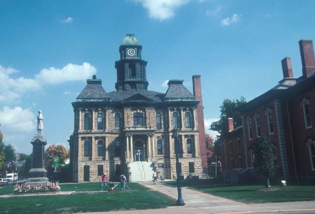
Photo: Calvin Beale, USDA (official duties), public domain · Wikimedia Commons
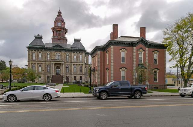
Photo: Christopher L. Riley, CC BY-SA 4.0 · Wikimedia Commons
Local history sources: touringohio.com · en.wikipedia.org · en.wikipedia.org · hmdb.org
Historic places
8 places in Millersburg on the National Register of Historic Places. Press a pin or a name for its whole record.
-
Adams, G., HouseBuilding · Millersburg · listed 1984
- Address
- 103 N. Clay St.
- Where
- Millersburg, Holmes County · ZIP 44654
- What it is
- Building
- Listed on the National Register
- 1984
- NRIS reference number
- 84003730
- Coordinates
- 40.55585, -81.91735
National Register file (NPS) ↗ Search Wikipedia ↗ Street map and directions ↗ On the Cracked Buckeye map
-
Brightman HouseBuilding · Millersburg · listed 1974
- Address
- Wooster Rd. and Walnut St.
- Where
- Millersburg, Holmes County · ZIP 44654
- What it is
- Building
- Listed on the National Register
- 1974
- NRIS reference number
- 74001528
- Coordinates
- 40.55938, -81.91503
National Register file (NPS) ↗ Search Wikipedia ↗ Street map and directions ↗ On the Cracked Buckeye map
-
Cary, G.W., HouseBuilding · Millersburg · listed 1984
- Address
- 200 N. Washington St.
- Where
- Millersburg, Holmes County · ZIP 44654
- What it is
- Building
- Listed on the National Register
- 1984
- NRIS reference number
- 84003734
- Coordinates
- 40.55566, -81.91805
National Register file (NPS) ↗ Search Wikipedia ↗ Street map and directions ↗ On the Cracked Buckeye map
-
Cary, Hiram W., HouseBuilding · Millersburg · listed 1984
- Address
- 101 N. Clay St.
- Where
- Millersburg, Holmes County · ZIP 44654
- What it is
- Building
- Listed on the National Register
- 1984
- NRIS reference number
- 84003736
- Coordinates
- 40.55567, -81.91734
National Register file (NPS) ↗ Search Wikipedia ↗ Street map and directions ↗ On the Cracked Buckeye map
-
Disciple-Christian ChurchBuilding · Millersburg · listed 1984
- Address
- 100 N. Clay St.
- Where
- Millersburg, Holmes County · ZIP 44654
- What it is
- Building
- Listed on the National Register
- 1984
- NRIS reference number
- 84003738
- Coordinates
- 40.55567, -81.91687
National Register file (NPS) ↗ Search Wikipedia ↗ Street map and directions ↗ On the Cracked Buckeye map
-
Holmes County Courthouse And JailBuilding · Millersburg · listed 1974
- Address
- Courthouse Sq.
- Where
- Millersburg, Holmes County · ZIP 44654
- What it is
- Building
- Listed on the National Register
- 1974
- NRIS reference number
- 74001529
- Coordinates
- 40.55396, -81.91697
National Register file (NPS) ↗ Search Wikipedia ↗ Street map and directions ↗ On the Cracked Buckeye map
-
Koch, John E., Jr., HouseBuilding · Millersburg · listed 1984
- Address
- 107 N. Washington St.
- Where
- Millersburg, Holmes County · ZIP 44654
- What it is
- Building
- Listed on the National Register
- 1984
- NRIS reference number
- 84003740
- Coordinates
- 40.55638, -81.91842
National Register file (NPS) ↗ Search Wikipedia ↗ Street map and directions ↗ On the Cracked Buckeye map
-
United Methodist ChurchBuilding · Millersburg · listed 1984
- Address
- N. Washington St.
- Where
- Millersburg, Holmes County · ZIP 44654
- What it is
- Building
- Listed on the National Register
- 1984
- NRIS reference number
- 84003744
- Coordinates
- 40.55602, -81.91865
National Register file (NPS) ↗ Search Wikipedia ↗ Street map and directions ↗ On the Cracked Buckeye map
Source: National Park Service, National Register of Historic Places point file. The listing year is shown where NPS's certification date agrees with the listing's reference number. Listing recognizes significance; it does not restrict a private owner.
Water
Mostly private wells The water here
- Millersburg Village71% of residentsGroundwater wells (2 wells)
- Berlin Water Company17% of residentsGroundwater wells (4 wells)
- Bloomfield Water Company10% of residentsGroundwater wells (5 wells)
- Walnut Creek Water Co.2% of residentsGroundwater wells (3 wells)
- Nashville Village0% of residentsGroundwater wells (2 wells)
Hospitals, fire stations and more
Inside Millersburg's boundary: 1 hospital, 1 dialysis center, 1 nursing home, 2 public schools, 1 poor-rated bridge, 3 libraries, 1 museum, 1 police station, 1 Toxics Release Inventory facility and 1 spill case. Press a pin or a name for its whole record and its source.
Hospitals (1)
-
Pomerene HospitalGeneral hospital · Millersburg
- What it is
- General hospital
- Address
- 981 Wooster Road, Millersburg, OH 44654
- County
- Holmes County
- Beds
- 71
- Ownership
- Non-profit
- Medicare overall rating
- 3 of 5 stars
- Emergency department (Medicare)
- Yes
- Phone
- (330) 674-1015
- Medicare ID
- 360148
Medicare Care Compare ↗ Hospital's website ↗ Where HIFLD got this record ↗ HIFLD hospitals (source) ↗ Street map and directions ↗
Source: HIFLD hospitals inventory via FEMA (closed hospitals it still lists left out, hospitals opened since added), with Medicare Care Compare ratings matched by name and address.
Dialysis centers (1)
-
Davita Millersburg DialysisDialysis · Millersburg
- Address
- 1649 S. Washington Street, Millersburg, OH 44654
- Dialysis stations
- 9
- Medicare star rating
- 3 of 5 stars
- Services
- in-center hemodialysis, peritoneal dialysis
- Ownership
- for profit
- Chain
- DaVita
- Medicare certified since
- 2015-04-09
- Phone
- (330) 674-0476
- Medicare ID
- 362825
Medicare Care Compare ↗ CMS dialysis facility list (source) ↗ Street map and directions ↗
Source: CMS dialysis facility list, September 2026, geocoded with the Census Bureau batch geocoder (an address it could not place sits at its ZIP center).
Nursing homes (1)
-
Majora Lane Ctr for Rehab & Nsg Care Inc4 of 5 stars · Millersburg
- Address
- 105 Majora Lane, Millersburg, OH 44654
- Certified beds
- 80
- Residents on an average day
- 60
- Medicare overall rating
- 4 of 5 stars
- Health inspections
- 3 of 5 stars
- Staffing
- 3 of 5 stars
- Quality measures
- 5 of 5 stars
- Penalties since 2023
- none
- Ownership
- For profit - Individual
- Chain
- ALTERCARE
- Takes
- Medicare and Medicaid
- Phone
- (330) 674-4444
- Medicare ID
- 365632
Medicare Care Compare ↗ CMS nursing home data (source) ↗ Street map and directions ↗
Source: CMS Care Compare nursing home provider and penalties files; Medicare star ratings run 1 to 5.
Public schools (2)
-
Millersburg Elementary School5 of 5 stars · Millersburg
- Address
- 430 E Jackson St, Millersburg, OH 44654
- School district
- West Holmes Local School District
- Kind (NCES)
- Regular School
- Students, 2023-24
- 385
- Teachers (full-time equivalent)
- 21
- Report card, 2025-26
- 5 of 5 stars
- Performance index
- 87.9%
- Ohio building IRN
- 024869
- NCES school ID
- 390476902947
NCES school record ↗ Ohio School Report Card ↗ Street map and directions ↗
-
West Holmes Digital Academy2 of 5 stars · Millersburg
- Address
- 1291 Massillon Rd Ste B, Millersburg, OH 44654
- School district
- West Holmes Local School District
- Kind (NCES)
- Regular School
- Students, 2023-24
- 26
- Teachers (full-time equivalent)
- 2
- Report card, 2025-26
- 2 of 5 stars
- Performance index
- 60.5%
- Four-year graduation rate
- 73.7%
- Ohio building IRN
- 019694
- NCES school ID
- 390476906130
NCES school record ↗ Ohio School Report Card ↗ Street map and directions ↗
Source: NCES EDGE public school locations 2024-25 and Common Core of Data 2023-24 (type, students, teachers); Ohio School Report Cards 2025-26 (Department of Education and Workforce), matched by name within the district.
Bridges rated poor (1)
-
SR 39 over Holmes Cty TrailPoor · built 1940
- Condition
- Poor: a deck, superstructure, substructure or culvert rated 4 or below on the 0 to 9 scale
- What it is
- Bridge
- Built
- 1940
- Length
- 11 ft
- Owner
- State
- Vehicles a day
- 9,171
- Coordinates
- 40.55431, -81.92123
National Bridge Inventory (source) ↗ Street map and directions ↗
Source: FHWA National Bridge Inventory 2025. "Poor" means one major part rated 4 or below on the 0 to 9 scale; it calls for repair, not closing, unless the state posts or closes the bridge.
Public libraries (3)
-
Holmes County District Public LibraryCentral library · Millersburg
- Address
- 3102 Glen Dr., Millersburg, OH 44654
- What it is
- Central library
- Library system
- Holmes County District Public Library
- Open
- 2,652 hours a year, 52 weeks
- Building
- 16,650 sq ft
- System's visits, FY2024
- 87,360
- System's loans, FY2024
- 533,282
- People the system serves
- 44,677
- Phone
- (330) 674-5972
IMLS Public Libraries Survey (source) ↗ Street map and directions ↗
-
Holmes County District Public Library (Millersburg)Bookmobile stop · Millersburg
- Address
- 3102 Glen Dr., Millersburg, OH 44654
- What it is
- Bookmobile stop
- Library system
- Holmes County District Public Library
- Open
- 1,530 hours a year, 51 weeks
- System's visits, FY2024
- 87,360
- System's loans, FY2024
- 533,282
- People the system serves
- 44,677
- Phone
- (330) 674-5972
IMLS Public Libraries Survey (source) ↗ Street map and directions ↗
-
Holmes County District Public Library Bs2Bookmobile stop · Millersburg
- Address
- 3102 Glen Dr., Millersburg, OH 44654
- What it is
- Bookmobile stop
- Library system
- Holmes County District Public Library
- Open
- 255 hours a year, 51 weeks
- System's visits, FY2024
- 87,360
- System's loans, FY2024
- 533,282
- People the system serves
- 44,677
- Phone
- (330) 674-5972
IMLS Public Libraries Survey (source) ↗ Street map and directions ↗
Source: IMLS Public Libraries Survey FY2024 (outlets and their systems). Any Ohio resident can get a free card at any Ohio public library.
Museums, historical societies, gardens and zoos (1)
-
Historical Society Holmes CountyHistorical society · Millersburg
- What it is
- Historical society
- City
- Millersburg
- Coordinates
- 40.55861, -81.91797
Search Wikipedia ↗ IMLS Museum Data Files (source) ↗ Street map and directions ↗
The museum list is IMLS's 2018 file; a museum may have closed or moved since.
Source: IMLS Museum Data Files, 2018.
Police stations (1)
-
Millersburg Police DepartmentMillersburg
- Address
- 6 North Washington Street, Millersburg, OH 44654
- Coordinates
- 40.55451, -81.91891
USGS National Map structures (source) ↗ Street map and directions ↗
Source: USGS National Map structures, police stations, corrected and completed by hand (September 2026). The department that answers a call is set by jurisdiction, not by distance.
Facilities reporting toxic releases (1)
-
Wastequip Manufacturing CoToxics Release Inventory · Millersburg
- Address
- 930 Massillon Road, Millersburg, OH 44654
- County
- Holmes County
- Status
- Reports to the Toxics Release Inventory (active)
- EPA program ID
- 44654NVRNM930MA
- EPA registry ID
- 110009428690
EPA facility record ↗ EPA Facility Registry Service (source) ↗ Street map and directions ↗
Source: EPA Facility Registry Service, Toxics Release Inventory reporters. Reporting a release is required of large users of listed chemicals; it is not by itself a violation.
Spills reported since 2021 (1)
-
Sewage Sludge / Biosolids2021-12-11 · Millersburg
- Reported
- 2021-12-11
- What spilled
- Sewage Sludge / Biosolids
- Where
- Millersburg, Holmes County
- Ohio EPA district office
- NEDO
- Ohio EPA case number
- 2112EPA0001847
Ohio EPA spill reports (source) ↗ Street map and directions ↗
Source: Ohio EPA emergency response spill reports, 2021 to September 2026, one point per case where Ohio EPA placed it. A report is what the caller or responder recorded; amounts are often blank or estimated.
Its ZIP codes
Each ZIP code that touches Millersburg, with the share of its residents who live here and the same headline figures as the ZIP page.
| ZIP | Share | Water | Radon | Home value | Schools | Flood |
|---|---|---|---|---|---|---|
| 44654 Berlin Township and Millersburg | 15% | Mostly private wells | 7.4 pCi/L average radon | Median year built 1986 | West Holmes Local · 3.5 stars overall | 1.9% of residents in the 1% floodplain |
Local government
Who holds office in Millersburg, how its elections and ballot issues came out, and the state auditor's record.
Elections for office
| Date | Office | Candidates and votes |
|---|---|---|
| 2025-11-04 | Member of Council (unofficial count) | Ryan Hershberger 302, 25.02%; Brent Hofstetter 320, 26.51%; Bob Shoemaker 296, 24.52%; Andy Zoltars 289, 23.94% |
| 2023-11-07 | Member of Council | Ryan Hershberger 356, 28.53%; Andrea Kellogg 434, 34.78%; Thomas Vaughn 458, 36.7% |
| 2023-11-07 | Mayor | Kelly Hoffee 484, 55.82%; Jeff Huebner 383, 44.18% |
| 2019-11-05 | Member of Council (unofficial count) | Kevin Brown 178, 15.6%; Ryan Hershberger 95, 8.33%; Kelly Hoffee 300, 26.29%; David Shrock 181, 15.86%; Tom Vaughn 387, 33.92% |
| 2019-11-05 | Mayor (unofficial count) | Jeff Huebner 350, 53.19%; Andrea Kellogg 95, 14.44%; Dan Miller 213, 32.37% |
| 2019-11-05 | Clerk-Treasurer (unofficial count) | Karen Shaffer 535, 100.0% |
Winners in bold. Results from the county board of elections' official canvass unless marked.
Auditor of State record
- No fiscal caution, watch or emergency on the Auditor of State's lists.
- Financial Audit, 2023 to 2024, released 2025-10-21
The county
Holmes County: 14 ZIP codes, 21 cities, villages and townships, 42,404 people.
Nearby places
Rain and snow
How much has actually fallen on Millersburg, day by day, from 1893 to now. Daily totals, not averages.
- rain, last 30 days
- 1.14 in
- 2026-09-30 to 2026-10-29
- rain so far in 2026
- 37.7 in
- 2.5 in above normal for the date
- snow so far in 2026
- 17.5 in
- a normal year brings 21.2 in
- a normal year
- 41.2 in
- average of 30 years, 1991-2020
| Month | Rain (in) | Snow (in) | Days counted |
|---|---|---|---|
| October 2026 | 1.14 | — | 29 |
| September 2026 | 3.06 | — | 30 |
| August 2026 | 6.88 | — | 31 |
| July 2026 | 2.12 | — | 31 |
| June 2026 | 3.47 | — | 30 |
| May 2026 | 6.96 | — | 31 |
| April 2026 | 6.27 | — | 30 |
| March 2026 | 4.76 | 2.0 | 31 |
| February 2026 | 1.33 | 2.2 | 28 |
| January 2026 | 1.67 | 13.3 | 31 |
| December 2025 | 1.95 | 9.9 | 31 |
| November 2025 | 1.89 | — | 30 |
| Wettest year | 1990 — 54.8 in |
|---|---|
| Driest year | 1963 — 24.5 in |
| Snowiest year | 1910 — 72.3 in |
| Wettest day on record | 7 August 1935 — 6.76 in |
| Heaviest snowfall in a day | 2 December 1974 — 17.73 in |
| Deepest snow on the ground | 17 February 1910 — 21.82 in |
Estimated, not measured. No rain gauge has ever stood inside Millersburg, so every figure here is worked out from the gauges around it - the nearest ones weighted most. Treat them as close estimates rather than readings.
48,746 days of records, 1893-01-01 to 2026-10-29. Source: NOAA NCEI GHCN-Daily, 3,240 gauges in and around Ohio. A day is "gauged" when a gauge standing inside the boundary reported it, and the value is the mean of those gauges. Otherwise it is interpolated by inverse distance from every gauge reporting within 50 miles. Nothing is carried forward, back-filled or smoothed. Against NOAA nClimDiv county monthly precipitation over 136,848 complete county-months (checked 2026-10-31): correlation 0.9515, median absolute difference 0.217 in a month. Built 2026-10-31 from the Cracked Buckeye precipitation archive. Snow is the softer number — snowfall is measured by hand with a ruler, no agency publishes a gridded county snowfall series, and blowing snow defeats every observer.
Environmental permits and filings
What Ohio EPA has on file for Millersburg: permits, inspections, violations, cleanups and the state loans behind sewer and water work. Every line links to the agency's own document.
- facilities and sites on file
- 16
- those placed on the map inside Millersburg
| Program | Facilities and sites |
|---|---|
| Public drinking water | 6 |
| Hazardous waste | 3 |
| Site assessment | 2 |
| Source-water protection | 2 |
| Air pollution | 1 |
| Contaminated-site cleanup | 1 |
| Sewer and water-line construction | 1 |
| Date | Facility or site | What |
|---|---|---|
| WEST HOLMES HIGH SCHOOL PWS | Public drinking water compliance letter | |
| HOLMES COUNTY GARAGE PWS | Public drinking water compliance letter | |
| MILLERSBURG VILLAGE PWS | Public drinking water plan | |
| MILLERSBURG VILLAGE PWS | Public drinking water report | |
| MILLERSBURG VILLAGE PWS | Public drinking water compliance letter | |
| CASTLE NURSING HOMES, INC PWS | Public drinking water report | |
| MILLERSBURG VILLAGE PWS | Public drinking water plan | |
| WEST HOLMES HIGH SCHOOL PWS | Public drinking water plan | |
| WEST HOLMES HIGH SCHOOL PWS | Public drinking water inspection | |
| MILLERSBURG VILLAGE PWS | Public drinking water plan | |
| MILLERSBURG VILLAGE PWS | Public drinking water inspection | |
| WEST HOLMES HIGH SCHOOL PWS | Public drinking water violation resolved | |
| WEST HOLMES HIGH SCHOOL PWS | Public drinking water notice of violation | |
| CASTLE NURSING HOMES, INC PWS | Public drinking water letter | |
| MILLERSBURG VILLAGE PWS | Public drinking water letter | |
| MILLERSBURG VILLAGE PWS | Public drinking water inspection | |
| HOLMES COUNTY GARAGE PWS | Public drinking water plan | |
| HOLMES COUNTY GARAGE PWS | Public drinking water inspection | |
| CASTLE NURSING HOMES, INC PWS | Public drinking water plan | |
| CASTLE NURSING HOMES, INC PWS | Public drinking water inspection | |
| MILLERSBURG VILLAGE PWS | Public drinking water inspection | |
| CASTLE NURSING HOMES, INC PWS | Public drinking water inspection | |
| MILLERSBURG VILLAGE PWS | Public drinking water violation resolved | |
| MILLERSBURG VILLAGE PWS | Public drinking water report | |
| WEST HOLMES HIGH SCHOOL PWS | Public drinking water compliance letter |
Source: Ohio EPA eDocument portal (edocpub.epa.ohio.gov), indexed 2026-10-14. Facilities are placed on the map from Ohio EPA's own map layers, EPA's Facility Registry, coordinates written in the filings, or a geocoded street address. A permit filed under a private person's name (most are household septic systems) is counted but never named, placed or linked; licenses for individual workers and open-burning notices are left out entirely.
Quick answers
What county is Millersburg, Ohio in?
Millersburg is a village in Holmes County, Ohio, with 3,151 residents.
When was Millersburg, Ohio founded?
Millersburg was settled 1815 (earlier town, laid out in November); laid out 1824; incorporated 1835. Founders on record: Charles Miller and Adam Johnson. Source
How did Millersburg, Ohio get its name?
Named for Charles Miller, one of the town's two founders and proprietors. Source
What ZIP code is Millersburg, Ohio?
Most of Millersburg is in ZIP code 44654.
Where does Millersburg, Ohio get its water?
The main water source for Millersburg (Millersburg Village): Mostly private wells.
Cite this page
Cite this page as:
Cracked Buckeye, "Millersburg, Holmes County", https://crackedbuckeye.com/place/millersburg/, built 2026-10-31, accessed [date].
How to cite · Report a correction · Built 2026-10-31
