Local events in Miami Township, Montgomery County
43 events in the next 90 days from 2 public calendars. All local events in Miami Township, Montgomery County
Checked October 20; the events page is refreshed daily.
How Miami Township, Montgomery County began
Miami Township sits in the south-central part of Montgomery County along the Great Miami River, named for the Miami people who once controlled the region. By 1833 it already supported eight gristmills, six sawmills, six distilleries, and a cotton factory, a sign of an established water-powered farm economy well before the Civil War. The city of Miamisburg, which grew from Zechariah Hole's settlement of about 1797 and was platted in 1818, grew up inside the township's boundaries but became and remains its own separate incorporated municipality. The unincorporated township grew comparatively slowly until Interstate 675 was completed after 1980, after which it became a fast-growing suburban corridor; it is now home to roughly 30,000 residents outside Miamisburg.
Settled 1796 (William Hole, on 150 acres in Section 25 east of the future Miamisburg; his parents Zachariah and Phoebe Hole followed the same winter).
Where the name comes from
The township takes its name, like the Great Miami River that runs beside it, from the Miami people (Myaamia), an Algonquian-speaking nation whose territory included this part of the Ohio country before the Treaty of Greenville (1795) and subsequent cessions pushed their settlements further northwest.
Before the town
No village, trail, or treaty line specific to the unincorporated township (as distinct from the city of Miamisburg) is recorded in the sources reviewed. The Miamisburg Mound, one of the largest Adena-culture conical burial mounds in the eastern United States (built roughly 800 BC-AD 100), stands within Miamisburg's own city limits per its National Register address and Wikipedia listing, even though it shares Miami Township's ZIP code (45342). The township's name itself preserves the memory of the Miami (Myaamia) nation, whose territory this was before the Treaty of Greenville (1795).
Nations recorded here: Miami (Myaamia), Shawnee, Adena culture.
Timeline
- — William Hole located on 150 acres in Section 25, east of the future Miamisburg; that winter his parents, Zachariah and Phoebe (Clark) Hole, followed from Virginia with the rest of the family and settled on the same section.
- — Zechariah Hole settled with his family from Virginia at what became Miamisburg, inside the future Miami Township, in a community first called Hole's Station.
- — A block-house was built on part of Zachariah Hole's land, with a stockade thrown around it for protection against the Indians; the fortified site became known as 'Hole's Station' and a headquarters for parties prospecting for or locating land in the region.
- — Col. William Dodds and family settled in Section 21, near where the town of Carrollton would later stand; Alexander Nutz, of Pennsylvania, settled the same year one mile south of Hole's Station and, per old residents who recalled it, already had a bearing orchard by the War of 1812.
- — William Lamme, arriving from Kentucky with his wife and five children, built the first grist-mill in this part of the township in a narrow gorge on Hole's Creek; the same year Samuel Boltin, a Dunkard (German Baptist) preacher, settled on the west bank of the Miami River and became one of the region's pioneer school teachers.
- — A German Baptist (Dunkard) church was organized at the cabin of pioneer George V. Stettler's family, who had settled a mile southwest of Hole's Station in 1804; the congregation was still in existence in 1882.
- — Miamisburg was platted in February by Peter and John Treon, Jacob Kercher and Emanuel Gebhart; a surviving newspaper notice for the first lot sale, on February 20, identifies the site as being known by the name 'Hole's Station.' A post office followed in June 1822, with Adam Shuey as postmaster.
- — The town of Carrollton (later West Carrollton), inside Miami Township along the Great Miami, was laid out April 27 by Moses Smith, H. G. Phillips and a third proprietor named Alexander.
- — Miami Township contained eight gristmills, six sawmills, six distilleries, and one cotton factory.
- — Miamisburg, the largest settlement inside the township, incorporated as a village (later a city), formally separating its governance from the township.
- — Completion of Interstate 675 placed Miami Township at the junction of two major transportation corridors, accelerating suburban growth in the unincorporated township.
Stories
A township of mills and stills
Long before Dayton's suburbs reached this far south, Miami Township was a working landscape of water-powered industry. The 1833 county tally recorded eight gristmills grinding wheat and corn, six sawmills cutting the township's timber, six distilleries turning surplus grain into whiskey, and a cotton factory -- an unusually dense concentration of mills for a rural Ohio township, fed by the Great Miami River and its tributary creeks. That industrial base predates the city of Miamisburg's own 19th-century growth and set the pattern of small mill hamlets, like the one that grew up around the Schuter family's carpenter shop on the Alexandersville-Bellbrook Road, that still leave their names on the township's back roads.
Hole's Station
The oldest settlement in Miami Township began not as a town but as a fort. William Hole staked land in Section 25 in 1796, and that winter his parents, Zachariah and Phoebe Hole, followed from Virginia with the rest of the family to join him. By the summer of 1799, with rumors of Indian trouble circulating along the frontier, a block-house went up on Zachariah's land, ringed by a stockade, and neighboring families gathered inside it at night for safety before dispersing each morning to their own clearings. The fortified post, known as Hole's Station, became a natural headquarters for the land-seekers and surveying parties who kept arriving in the Great Miami valley, among them Maj. George Adams, who fought through the War of 1812, and Anthony Chevalier, a French veteran who had crossed the Atlantic under Lafayette to fight for American independence. When the town of Miamisburg was platted on the same ground in February 1818, the newspaper notice announcing the first sale of lots still identified the site by its old name, 'known by the name of Hole's Station' -- the fort's name outliving the fort by two decades.
The Pease Homestead
Northwest of Centerville on Alexander-Bellbrook Road stands the Pease Homestead, a farmhouse the National Register dates to around 1820 and lists within Miami Township. It is one of a handful of early farmsteads in the township -- including the Schuter Carpenter Shop and House further west -- that survive from the first generation of settlement after the township's mills were already running. Unlike several nearby historic properties that share Miami Township's ZIP codes with Washington Township and the city of Miamisburg, the National Register's own address listing places the Pease Homestead squarely inside Miami Township's boundary.
Photographs
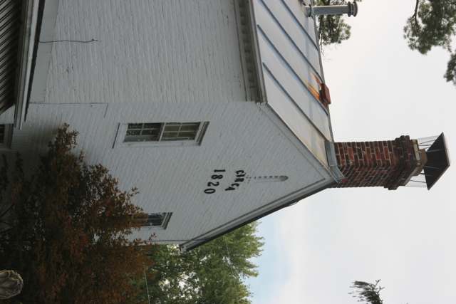
Photo: Pjsham, CC BY-SA 3.0 · Wikimedia Commons
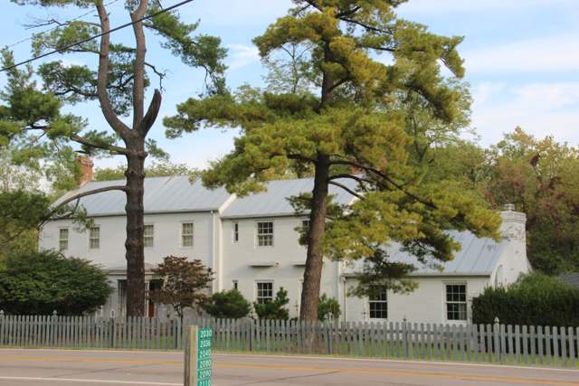
Photo: Pjsham, CC BY-SA 3.0 · Wikimedia Commons
Local history sources: en.wikipedia.org · en.wikipedia.org · en.wikipedia.org · ohiohistory.org · en.wikipedia.org · miamitownship.com · commons.wikimedia.org · commons.wikimedia.org · archive.org
Historic places
2 places in Miami Township, Montgomery County on the National Register of Historic Places. Press a pin or a name for its whole record.
-
Pease HomesteadBuilding · Centerville · listed 1980
- Address
- 2123 Alexander-Bellbrook Rd.
- Where
- Centerville, Montgomery County · ZIP 45459
- What it is
- Building
- Listed on the National Register
- 1980
- NRIS reference number
- 80003169
- Coordinates
- 39.67156, -84.20638
National Register file (NPS) ↗ Search Wikipedia ↗ Street map and directions ↗ On the Cracked Buckeye map
-
Schuter Carpenter Shop and HouseBuilding · West Carrollton · listed 1980
- Address
- 3224 W. Alexandersville-Bellbrook Rd.
- Where
- West Carrollton, Montgomery County · ZIP 45449
- What it is
- Building
- Listed on the National Register
- 1980
- NRIS reference number
- 80003179
- Coordinates
- 39.67350, -84.22682
National Register file (NPS) ↗ Search Wikipedia ↗ Street map and directions ↗ On the Cracked Buckeye map
Source: National Park Service, National Register of Historic Places point file. The listing year is shown where NPS's certification date agrees with the listing's reference number. Listing recognizes significance; it does not restrict a private owner.
Water
Groundwater wells in the Great Miami River buried-valley aquifer at Miamisburg The water here
- Montgomery County Water Services 150% of residentsGreat Miami Buried Valley Aquifer wells (recharged by Great Miami & Mad Rivers)
- Miamisburg City32% of residentsGreat Miami Buried Valley Aquifer (wells)
- West Carrollton City15% of residentsGreat Miami Buried Valley Aquifer (wells)
- Oakwood Village MHP3% of residentsGreat Miami Buried Valley Aquifer wells (recharged by Great Miami & Mad Rivers)
- Quarry Lakes MHP Llc0% of residentsGroundwater wells (2 wells)
- Jefferson Regional Water Authority0% of residentsGroundwater wells (2 wells)
- Springboro0% of residentsGreat Miami Buried Valley Aquifer (own wells)
- Dayton Public Water System0% of residentsGreat Miami Buried Valley Aquifer wells (recharged by Great Miami & Mad Rivers)
- Bellbrook Water Works0% of residentsMiami Valley Buried Valley Aquifer (city wells)
Hospitals, fire stations and more
Inside Miami Township, Montgomery County's boundary: 1 hospital, 3 nursing homes, 2 fire and EMS stations, 1 college, 3 public schools, 2 private schools, 1 poor-rated bridge, 1 library, 4 museums, 6 public charging sites, 2 Superfund sites, 1 Toxics Release Inventory facility, 2 stations and terminals and 12 spill cases. Press a pin or a name for its whole record and its source.
Hospitals (1)
-
Kettering Behavioral Medicine CenterPsychiatric hospital · Dayton
- What it is
- Psychiatric hospital
- Address
- 5350 Lamme Road, Dayton, OH 45439
- County
- Montgomery County
- Beds
- 60
- Ownership
- Non-profit
- Phone
- (937) 534-4600
Where HIFLD got this record ↗ HIFLD hospitals (source) ↗ Street map and directions ↗
Source: HIFLD hospitals inventory via FEMA (closed hospitals it still lists left out, hospitals opened since added), with Medicare Care Compare ratings matched by name and address.
Nursing homes (3)
-
Vienna Springs Health Campus5 of 5 stars · Dayton
- Address
- 2510 Vienna Pkwy, Dayton, OH 45459
- Certified beds
- 54
- Residents on an average day
- 51
- Medicare overall rating
- 5 of 5 stars
- Health inspections
- 4 of 5 stars
- Staffing
- 3 of 5 stars
- Quality measures
- 5 of 5 stars
- Penalties since 2023
- none
- Ownership
- For profit - Individual
- Chain
- TRILOGY HEALTH SERVICES
- Takes
- Medicare and Medicaid
- Phone
- (937) 741-7896
- Medicare ID
- 366490
Medicare Care Compare ↗ CMS nursing home data (source) ↗ Street map and directions ↗
-
Walnut Creek Nursing Center1 of 5 stars · Kettering
- Address
- 5070 Lamme Road, Kettering, OH 45439
- Certified beds
- 139
- Residents on an average day
- 104
- Medicare overall rating
- 1 of 5 stars
- Health inspections
- 2 of 5 stars
- Staffing
- 1 of 5 stars
- Quality measures
- 4 of 5 stars
- Penalties since 2023
- none
- Ownership
- For profit - Corporation
- Chain
- LIONSTONE CARE
- Continuing care retirement community
- Yes
- Takes
- Medicare and Medicaid
- Phone
- (937) 293-7703
- Medicare ID
- 365821
Medicare Care Compare ↗ CMS nursing home data (source) ↗ Street map and directions ↗
-
Wood Glen Alzheimer's Community3 of 5 stars · Dayton
- Address
- 3800 Summit Glen Drive, Dayton, OH 45449
- Certified beds
- 148
- Residents on an average day
- 142
- Medicare overall rating
- 3 of 5 stars
- Health inspections
- 3 of 5 stars
- Staffing
- 1 of 5 stars
- Quality measures
- 5 of 5 stars
- Penalties since 2023
- none
- Ownership
- For profit - Limited Liability company
- Chain
- COMMUNICARE HEALTH
- Takes
- Medicare and Medicaid
- Phone
- (937) 436-2273
- Medicare ID
- 365722
Medicare Care Compare ↗ CMS nursing home data (source) ↗ Street map and directions ↗
Source: CMS Care Compare nursing home provider and penalties files; Medicare star ratings run 1 to 5.
Fire and EMS stations (2)
-
Miami Valley Fire District Station 51Miamisburg
- Address
- 10899 Wood Road, Miamisburg, OH 45342
- Coordinates
- 39.58828, -84.24884
USGS National Map structures (source) ↗ Street map and directions ↗
-
Miami Valley Fire District Station 52Miamisburg
- Address
- 2710 Lyons Road, Miamisburg, OH 45342
- Coordinates
- 39.62748, -84.22027
USGS National Map structures (source) ↗ Street map and directions ↗
Source: USGS National Map structures (most Ohio records last updated 2019 to 2022), checked against the Columbus and Cleveland station lists. The department that answers a call is set by jurisdiction and mutual aid, not by distance.
Colleges (1)
-
Dayton Barber CollegeFor-profit two-year college · Miamisburg
- What it is
- For-profit two-year college
- City
- Miamisburg
- Students, 2023-24 (12-month count)
- 111
- Graduation rate
- 69% within three years (a class of 45)
- IPEDS unit ID
- 202453
College Navigator (NCES) ↗ IPEDS data (source) ↗ Street map and directions ↗
Source: NCES IPEDS 2024 directory, 2023-24 enrollment and tuition, graduation rates for the 2017 (four-year) and 2020 (two-year) entering classes.
Public schools (3)
-
Jane Chance Intermediate School4 of 5 stars · Miamisburg
- Address
- 10661 Wood Rd, Miamisburg, OH 45342
- School district
- Miamisburg City School District
- Kind (NCES)
- Regular School
- Students, 2023-24
- 301
- Teachers (full-time equivalent)
- 19.6
- Report card, 2025-26
- 4 of 5 stars
- Performance index
- 78.1%
- Ohio building IRN
- 011993
- NCES school ID
- 390443905617
NCES school record ↗ Ohio School Report Card ↗ Street map and directions ↗
-
Maddux-Lang PreschoolMiamisburg
- Address
- 4010 Crains Run Rd, Miamisburg, OH 45342
- Kind (NCES)
- Regular School
- Students, 2023-24
- 198
- Teachers (full-time equivalent)
- 9
- NCES school ID
- 390443905477
-
Miamisburg Middle School3.5 of 5 stars · Miamisburg
- Address
- 8668 Miamisburg Springboro Rd, Miamisburg, OH 45342
- School district
- Miamisburg City School District
- Kind (NCES)
- Regular School
- Students, 2023-24
- 1,116
- Teachers (full-time equivalent)
- 71
- Report card, 2025-26
- 3.5 of 5 stars
- Performance index
- 72.4%
- Ohio building IRN
- 039156
- NCES school ID
- 390443901316
NCES school record ↗ Ohio School Report Card ↗ Street map and directions ↗
Source: NCES EDGE public school locations 2024-25 and Common Core of Data 2023-24 (type, students, teachers); Ohio School Report Cards 2025-26 (Department of Education and Workforce), matched by name within the district.
Private schools (2)
-
Bishop Leibold SchoolPrivate, Catholic · Dayton
- Address
- 6666 Springboro Pike, Dayton, OH 45449
- Kind
- Catholic
- Students, 2023-24
- 207
- Teachers (full-time equivalent)
- 12.6
- Students per teacher
- 16.4286
- Phone
- (937) 657-4932
- NCES private school ID
- 01607829
-
Dayton Christian SchoolPrivate, conservative Christian · Miamisburg
- Address
- 9391 Washington Church Rd, Miamisburg, OH 45342
- Kind
- conservative Christian
- Students, 2023-24
- 832
- Teachers (full-time equivalent)
- 81.8
- Students per teacher
- 10.1711
- Phone
- (937) 291-7208
- NCES private school ID
- A0502714
Source: NCES Private School Survey 2023-24.
Bridges rated poor (1)
-
Alex Bell C0078 over Drainage DitchPoor · built 1968
- Condition
- Poor: a deck, superstructure, substructure or culvert rated 4 or below on the 0 to 9 scale
- What it is
- Culvert
- Built
- 1968
- Length
- 8 ft
- Owner
- County
- Vehicles a day
- 17,158
- Coordinates
- 39.67292, -84.21894
National Bridge Inventory (source) ↗ Street map and directions ↗
Source: FHWA National Bridge Inventory 2025. "Poor" means one major part rated 4 or below on the 0 to 9 scale; it calls for repair, not closing, unless the state posts or closes the bridge.
Public libraries (1)
-
Miami Township BranchBranch · Miamisburg
- Address
- 2718 Lyons Rd, Miamisburg, OH 45342
- What it is
- Branch
- Library system
- Dayton Metro Library
- Open
- 3,042 hours a year, 52 weeks
- Building
- 17,936 sq ft
- System's visits, FY2024
- 1,987,700
- System's loans, FY2024
- 4,831,439
- People the system serves
- 452,238
- Phone
- (937) 463-2665
IMLS Public Libraries Survey (source) ↗ Street map and directions ↗
Source: IMLS Public Libraries Survey FY2024 (outlets and their systems). Any Ohio resident can get a free card at any Ohio public library.
Museums, historical societies, gardens and zoos (4)
-
B Flyer WrightMuseum · Miamisburg
- What it is
- Museum
- City
- Miamisburg
- Coordinates
- 39.59358, -84.22920
Search Wikipedia ↗ IMLS Museum Data Files (source) ↗ Street map and directions ↗
The museum list is IMLS's 2018 file; a museum may have closed or moved since.
-
Carlisle Area Historical SocietyHistorical society · Miamisburg
- What it is
- Historical society
- City
- Miamisburg
- Coordinates
- 39.58869, -84.24509
Search Wikipedia ↗ IMLS Museum Data Files (source) ↗ Street map and directions ↗
The museum list is IMLS's 2018 file; a museum may have closed or moved since.
-
James M Cox Jr ArboretumArboretum or botanical garden · Dayton
- What it is
- Arboretum or botanical garden
- City
- Dayton
- Coordinates
- 39.65526, -84.22357
Search Wikipedia ↗ IMLS Museum Data Files (source) ↗ Street map and directions ↗
The museum list is IMLS's 2018 file; a museum may have closed or moved since.
-
National Archives At DaytonMuseum · Dayton
- What it is
- Museum
- City
- Dayton
- Coordinates
- 39.63000, -84.21843
Search Wikipedia ↗ IMLS Museum Data Files (source) ↗ Street map and directions ↗
The museum list is IMLS's 2018 file; a museum may have closed or moved since.
Source: IMLS Museum Data Files, 2018.
Public EV charging (6)
-
Austin Landing4 Level 2 · Miamisburg
- Address
- 10050 Innovation Dr, Miamisburg, OH 45342
- Ports
- 4 Level 2
- Plugs
- J1772
- Network
- AMPUP
- Hours
- Contact station for hours of availability
- Price
- $2.50 per hour
- Phone
- 833-692-6787
Station Locator (NREL) ↗ Alternative Fuels Data Center (source) ↗ Street map and directions ↗
-
Austin Park4 Level 2 · Miamisburg
- Address
- 9600 Summit Point Drive, Miamisburg, OH 45342
- Ports
- 4 Level 2
- Plugs
- J1772
- Network
- FLO
- Hours
- 24 hours daily
- Phone
- 888-356-8911
Station Locator (NREL) ↗ Alternative Fuels Data Center (source) ↗ Street map and directions ↗
-
Conifers Investors, LLC4 Level 2 · Miamisburg
- Address
- 2555 Lonesome Pine Drive, Miamisburg, OH 45342
- Ports
- 4 Level 2
- Plugs
- J1772
- Network
- Blink Network
- Hours
- 24 hours daily
- Phone
- 888-998-2546
Station Locator (NREL) ↗ Alternative Fuels Data Center (source) ↗ Street map and directions ↗
-
Meijer - Tesla Supercharger DC fast12 DC fast · Dayton
- Address
- 5858 N Springboro Pike, Dayton, OH 45449
- Ports
- 12 DC fast
- Plugs
- Tesla (NACS)
- Network
- Tesla
- Hours
- 24 hours daily
- Phone
- 877-798-3752
Station Locator (NREL) ↗ Alternative Fuels Data Center (source) ↗ Street map and directions ↗
-
MVRPC(EV#14)2 Level 2 · Miamisburg
- Address
- 2718 Lyons Road, Miamisburg, OH 45342
- Ports
- 2 Level 2
- Plugs
- J1772
- Network
- Blink Network
- Hours
- 24 hours daily
- Phone
- 888-998-2546
Station Locator (NREL) ↗ Alternative Fuels Data Center (source) ↗ Street map and directions ↗
-
MVRPC(EV#21)2 Level 2 · Dayton
- Address
- 6733 North Springboro Pike, Dayton, OH 45449
- Ports
- 2 Level 2
- Plugs
- J1772
- Network
- Blink Network
- Hours
- 24 hours daily
- Phone
- 888-998-2546
Station Locator (NREL) ↗ Alternative Fuels Data Center (source) ↗ Street map and directions ↗
Source: NREL Alternative Fuels Data Center station list (May 2026), public and open stations, the posts at one address counted as one site.
Superfund sites (2)
-
Layer ParkSuperfund program · Dayton
- Address
- 4999 Cordell Dr, Dayton, OH 45439
- County
- Montgomery County
- Status
- Superfund program site, not on the National Priorities List
- EPA program ID
- OHN000506381
- EPA registry ID
- 110070125065
EPA facility record ↗ EPA Facility Registry Service (source) ↗ Street map and directions ↗
-
Miami Township MercurySuperfund program · Moraine
- Address
- 4797 Joyce Drive, Moraine, OH 45439
- County
- Montgomery County
- Status
- Superfund program site, not on the National Priorities List
- EPA program ID
- OHN000508542
- EPA registry ID
- 110013798783
EPA facility record ↗ EPA Facility Registry Service (source) ↗ Street map and directions ↗
Source: EPA Facility Registry Service, Superfund (SEMS) and National Priorities List sites. Many program sites were assessed and needed no cleanup.
Facilities reporting toxic releases (1)
-
Aldrich Chemical Company, Llc (0857781883)Toxics Release Inventory · Miamisburg
- Address
- 3858 Benner Rd., Miamisburg, OH 45342
- County
- Montgomery County
- Status
- Reports to the Toxics Release Inventory (active)
- EPA program ID
- 45342STCNC3858B
- EPA registry ID
- 110000394163
EPA facility record ↗ EPA Facility Registry Service (source) ↗ Street map and directions ↗
Source: EPA Facility Registry Service, Toxics Release Inventory reporters. Reporting a release is required of large users of listed chemicals; it is not by itself a violation.
Stations and terminals (2)
-
Curbside bus stop in front of Sake Japanese Steak House & SuIntercity bus stop · Dayton
- What it is
- Intercity bus stop
- City
- Dayton
- Coordinates
- 39.63390, -84.20780
BTS Intermodal Passenger Connectivity Database (source) ↗ Street map and directions ↗
-
Curbside bus stop in front of TargetIntercity bus stop · Dayton
- What it is
- Intercity bus stop
- City
- Dayton
- Coordinates
- 39.63270, -84.21360
BTS Intermodal Passenger Connectivity Database (source) ↗ Street map and directions ↗
Source: BTS Intermodal Passenger Connectivity Database and National Transit Map (2025). Bus stops are counted on the card and drawn on the full map.
Spills reported since 2021 (12)
-
Oil Motor / Lube Oil / Vehicle2025-09-07 · Dayton
- Reported
- 2025-09-07
- What spilled
- Oil Motor / Lube Oil / Vehicle
- Largest amount reported
- 10 gallons
- Where
- Dayton, Montgomery County
- Ohio EPA district office
- SWDO
- Ohio EPA case number
- 2509EPA0001514
Ohio EPA spill reports (source) ↗ Street map and directions ↗
-
Other / All Other / Trade Name / Mixture / Solution Etc2024-09-25 · Miami Twp
- Reported
- 2024-09-25
- What spilled
- Other / All Other / Trade Name / Mixture / Solution Etc
- Where
- Miami Twp, Montgomery County
- Ohio EPA district office
- SWDO
- Ohio EPA case number
- 2409EPA0001648
Ohio EPA spill reports (source) ↗ Street map and directions ↗
-
Material Gray Reached water2024-08-06 · Miami Twp
- Reported
- 2024-08-06
- What spilled
- Material Gray
- Reached a waterway
- 57 - Holes Creek
- Where
- Miami Twp, Montgomery County
- Ohio EPA district office
- SWDO
- Ohio EPA case number
- 2408EPA0001350
Ohio EPA spill reports (source) ↗ Street map and directions ↗
-
Oil Motor / Lube Oil / Vehicle2024-06-03 · Miami Twp
- Reported
- 2024-06-03
- What spilled
- Oil Motor / Lube Oil / Vehicle
- Where
- Miami Twp, Montgomery County
- Ohio EPA district office
- SWDO
- Ohio EPA case number
- 2406EPA0000922
Ohio EPA spill reports (source) ↗ Street map and directions ↗
-
Fuel Oil/ Home Heating / Heating Oil2024-03-01 · Miami Twp
- Reported
- 2024-03-01
- What spilled
- Fuel Oil/ Home Heating / Heating Oil
- Where
- Miami Twp, Montgomery County
- Ohio EPA district office
- SWDO
- Ohio EPA case number
- 2403EPA0000319
Ohio EPA spill reports (source) ↗ Street map and directions ↗
-
Fuel Diesel / Diesel Fuel (Vehicle On Or Off Road)2024-01-19 · Miami Twp
- Reported
- 2024-01-19
- What spilled
- Fuel Diesel / Diesel Fuel (Vehicle On Or Off Road)
- Largest amount reported
- 150 gallons
- Where
- Miami Twp, Montgomery County
- Ohio EPA district office
- SWDO
- Ohio EPA case number
- 2401EPA0000094
Ohio EPA spill reports (source) ↗ Street map and directions ↗
-
Fuel Diesel / Diesel Fuel (Vehicle On Or Off Road)2023-08-07 · Miami Twp
- Reported
- 2023-08-07
- What spilled
- Fuel Diesel / Diesel Fuel (Vehicle On Or Off Road)
- Where
- Miami Twp, Montgomery County
- Ohio EPA district office
- SWDO
- Ohio EPA case number
- 2308EPA0001345
Ohio EPA spill reports (source) ↗ Street map and directions ↗
-
Oil Hydraulic Fluid(S)2023-05-19 · Miami Twp
- Reported
- 2023-05-19
- What spilled
- Oil Hydraulic Fluid(S)
- Where
- Miami Twp, Montgomery County
- Ohio EPA district office
- SWDO
- Ohio EPA case number
- 2305EPA0000818
Ohio EPA spill reports (source) ↗ Street map and directions ↗
-
Other / All Other / Trade Name / Mixture / Solution Etc2022-11-05 · Miami Twp
- Reported
- 2022-11-05
- What spilled
- Other / All Other / Trade Name / Mixture / Solution Etc
- Where
- Miami Twp, Montgomery County
- Ohio EPA district office
- SWDO
- Ohio EPA case number
- 2211EPA0001646
Ohio EPA spill reports (source) ↗ Street map and directions ↗
-
Fuel Diesel / Diesel Fuel (Vehicle On Or Off Road)2021-05-03 · Miami Twp
- Reported
- 2021-05-03
- What spilled
- Fuel Diesel / Diesel Fuel (Vehicle On Or Off Road)
- Largest amount reported
- 60 gallons
- Where
- Miami Twp, Montgomery County
- Ohio EPA district office
- SWDO
- Ohio EPA case number
- 2105EPA0000615
Ohio EPA spill reports (source) ↗ Street map and directions ↗
-
Oil Motor / Lube Oil / Vehicle2021-04-09 · Miami Twp
- Reported
- 2021-04-09
- What spilled
- Oil Motor / Lube Oil / Vehicle
- Where
- Miami Twp, Montgomery County
- Ohio EPA district office
- SWDO
- Ohio EPA case number
- 2104EPA0000489
Ohio EPA spill reports (source) ↗ Street map and directions ↗
-
Material White Reached water2026-08-13 · Miami Twp
- Reported
- 2026-08-13
- What spilled
- Material White
- Reached a waterway
- 99 - Unnamed
- Where
- Miami Twp, Montgomery County
- Ohio EPA district office
- SWDO
- Ohio EPA case number
- 2608EPA0001497
Ohio EPA spill reports (source) ↗ Street map and directions ↗
Source: Ohio EPA emergency response spill reports, 2021 to September 2026, one point per case where Ohio EPA placed it. A report is what the caller or responder recorded; amounts are often blank or estimated.
Its ZIP codes
Each ZIP code that touches Miami Township, Montgomery County, with the share of its residents who live here and the same headline figures as the ZIP page.
Local government
Who holds office in Miami Township, Montgomery County, how its elections and ballot issues came out, and the state auditor's record.
Elections for office
| Date | Office | Candidates and votes |
|---|---|---|
| 2025-11-04 | Trustee (unofficial count) | Drew Barry 4,054, 40.6%; Bob Matthews 1,845, 18.48%; Terry Posey Jr. 4,085, 40.92% |
Winners in bold. Results from the county board of elections' official canvass unless marked.
Auditor of State record
- No fiscal caution, watch or emergency on the Auditor of State's lists.
- Financial Audit, 2025, released 2026-09-10
- Financial Audit, 2024, released 2025-09-30
- OPERS Examination, 2024, released 2025-03-25
- Financial Audit, 2023, released 2024-10-17
The county
Montgomery County: 33 ZIP codes, 27 cities, villages and townships, 531,614 people.
Nearby places
Quick answers
What county is Miami Township, Ohio in?
Miami Township, Montgomery County is a township in Montgomery County, Ohio, with 30,816 residents.
When was Miami Township, Ohio founded?
Miami Township, Montgomery County was settled 1796 (William Hole, on 150 acres in Section 25 east of the future Miamisburg; his parents Zachariah and Phoebe Hole followed the same winter). Source
How did Miami Township, Ohio get its name?
The township takes its name, like the Great Miami River that runs beside it, from the Miami people (Myaamia), an Algonquian-speaking nation whose territory included this part of the Ohio country before the Treaty of Greenville (1795) and subsequent cessions pushed their settlements further northwest. Source
What ZIP code is Miami Township, Ohio?
Miami Township, Montgomery County is served by ZIP codes 45342, 45439, 45449 and 45459; 45342 holds the largest share of its residents.
Where does Miami Township, Ohio get its water?
The main water source for Miami Township, Montgomery County (Montgomery County Water Services 1): Groundwater wells in the Great Miami River buried-valley aquifer at Miamisburg.
Cite this page
Cite this page as:
Cracked Buckeye, "Miami Township, Montgomery County", https://crackedbuckeye.com/place/miami-township-montgomery-county/, built 2026-10-31, accessed [date].
How to cite · Report a correction · Built 2026-10-31
