Local events in Moraine
Moraine itself has 5 events posted in the next 90 days; the others here are within 10 miles. All local events in Moraine
Checked October 20; the events page is refreshed daily.
How Moraine began
Moraine sits on the Great Miami River south of Dayton, on ground named for the glacial moraine that shaped it. The land was farmed as part of Van Buren Township from the early 1800s, but the place that became the city grew up around a 1917 World War I aircraft plant, the Dayton-Wright Airplane Company, and later a General Motors Frigidaire and vehicle-assembly complex on the same site. A portion of Kettering broke away in 1953 to form Moraine Township, which incorporated as a village in 1957 and, after annexing part of Miami Township, became a city in 1965. Manufacturing has defined it ever since: GM's assembly plant closed in 2008 and the Chinese glassmaker Fuyao reopened the site in 2015-2016 with a $1 billion investment.
Incorporated 1957 (village); 1965 (city), by Portion of Kettering that seceded in 1953 to form Moraine Township.
Where the name comes from
The city takes its name from the glacial moraine — a ridge of debris left by the retreating Wisconsinan ice sheet — on which part of the area sits, along the Great Miami River valley. No source gives a more specific naming account (a founder, a platting document, or a naming date); this is the plain geological sense of the word as used locally.
Before the town
No known source ties a specific Native village, camp, trail or burial site to the ground now inside Moraine's city limits. The broader Great Miami valley through Montgomery County was, in the mid-to-late 1700s, contested and traveled ground of the Myaamia (Miami) and Shawnee, whose principal village of the era, Pickawillany, stood upriver near present Piqua, with other strongholds scattered along the Great Miami and Maumee valleys; the Shawnee, driven from southern Ohio by the mid-1600s Iroquois wars, resettled through this region before Tecumseh's Pan-Indian resistance ended in defeat at the Battle of the Thames in 1813. The Adena and Hopewell mound-building cultures were present in the valley many centuries earlier — the Miamisburg Mound, one of the largest conical mounds in North America, stands a few miles south in Miamisburg, not in Moraine — and the SunWatch Village Fort Ancient site (occupied for about 20 years around AD 1200) lies a few miles north near Dayton. The 1795 Treaty of Greenville cession line runs through this part of Ohio, opening the land to survey and settlement, but no source specifies its course through Moraine itself. For the county-wide picture of peoples, treaties and removal, see the Montgomery County file.
Nations recorded here: Shawnee, Miami.
Timeline
- — The Dayton-Wright Airplane Company opened Plant No. 1 at Moraine City to build aircraft for the U.S. war effort; more than 4,000 planes, including De Havilland DH-4s, were built there through 1923.
- — General Motors, which had bought Dayton-Wright in 1919, enlarged and upgraded the former aircraft plant to build Frigidaire refrigerators.
- — A portion of Kettering seceded and formed the new Moraine Township.
- — Moraine Township incorporated as a village.
- — Moraine incorporated as a city after annexing portions of Miami Township.
- — Frigidaire appliance manufacturing at the plant ended.
- — The plant reopened for GM vehicle assembly, building the Chevrolet S-10 Blazer and GMC S-15 Jimmy.
- — Salem Bear Creek Church (Salem Evangelical Lutheran Church), in the area bounded by Union Road, the Dayton-Germantown Pike and Bear Creek, was listed on the National Register of Historic Places.
- — GM Moraine Assembly closed, idling about 2,400 workers.
- — Chinese glassmaker Fuyao Glass Industry Group purchased the former GM plant.
- — Fuyao reached full-scale automotive glass production at the Moraine plant after investing about $1 billion.
Stories
From warplanes to refrigerators to Blazers
The same patch of ground on the Great Miami River has been rebuilt for a new industry roughly every generation. It opened in 1917 as Dayton-Wright Airplane Company's Plant No. 1, turning out De Havilland DH-4 observation planes on a line that eventually produced more than 4,000 aircraft before the company folded in 1923. General Motors, which had bought Dayton-Wright in 1919, enlarged and refitted the plant in 1926 to build Frigidaire refrigerators, a business that ran until 1979. Two years later GM reopened the same buildings to assemble Chevrolet S-10 Blazers and GMC S-15 Jimmys, later adding a paint shop and the DMAX diesel-engine joint venture in the 1990s. When GM Moraine Assembly finally closed in 2008, some 2,400 jobs went with it — one of the harder blows of that year's industrial downturn in the Dayton area. The site did not stay empty long: in 2014 the Chinese glass manufacturer Fuyao bought the plant, and by 2016 had invested roughly a billion dollars to bring automotive glass production up to full scale, keeping the same ground working a fourth time over.
Photographs
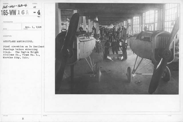
Photo: U.S. National Archives and Records Administration, public domain · Wikimedia Commons
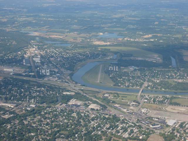
Photo: Nyttend, public domain · Wikimedia Commons
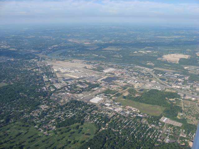
Photo: Nyttend, public domain · Wikimedia Commons
Photo: Vk2cz, CC BY-SA 3.0 · Wikimedia Commons
Local history sources: en.wikipedia.org · en.wikipedia.org · en.wikipedia.org · mcdwater.org · en.wikipedia.org · commons.wikimedia.org · commons.wikimedia.org · commons.wikimedia.org · commons.wikimedia.org
Historic places
1 place in Moraine on the National Register of Historic Places. Press a pin or a name for its whole record.
-
Salem Bear Creek Church, Salem Evangelical Lutheran ChurchBuilding · Germantown · listed 1990
- Address
- Roughly bounded by Union Rd., Dayton Germantown Pike, and Bear Creek
- Where
- Germantown, Montgomery County · ZIP 45342
- What it is
- Building
- Listed on the National Register
- 1990
- NRIS reference number
- 90001291
- Coordinates
- 39.68012, -84.30945
National Register file (NPS) ↗ Search Wikipedia ↗ Street map and directions ↗ On the Cracked Buckeye map
Source: National Park Service, National Register of Historic Places point file. The listing year is shown where NPS's certification date agrees with the listing's reference number. Listing recognizes significance; it does not restrict a private owner.
Water
Mad River Well Field wells along the Mad River east of Dayton, refilled by river water let into recharge lagoons The water here
- Montgomery County Water Services 197% of residentsGreat Miami Buried Valley Aquifer wells (recharged by Great Miami & Mad Rivers)
- Miamisburg City3% of residentsGreat Miami Buried Valley Aquifer (wells)
- Dayton Public Water System0% of residentsGreat Miami Buried Valley Aquifer wells (recharged by Great Miami & Mad Rivers)
- Oakwood Village MHP0% of residentsGreat Miami Buried Valley Aquifer wells (recharged by Great Miami & Mad Rivers)
- Quarry Lakes MHP Llc0% of residentsGroundwater wells (2 wells)
- Jefferson Regional Water Authority0% of residentsGroundwater wells (2 wells)
- Springboro0% of residentsGreat Miami Buried Valley Aquifer (own wells)
- West Carrollton City0% of residentsGreat Miami Buried Valley Aquifer (wells)
Hospitals, fire stations and more
Inside Moraine's boundary: 2 health centers, 1 dialysis center, 1 nursing home, 5 fire and EMS stations, 1 power plant, 3 public schools, 2 poor-rated bridges, 2 libraries, 1 police station, 4 Superfund sites, 18 Toxics Release Inventory facilities and 18 spill cases. Press a pin or a name for its whole record and its source.
Community health centers (2)
-
Elbee Road Community Health CenterHealth center · Moraine
- Run by
- a federally qualified health center
- Setting
- Clinic
- City
- Moraine
- Coordinates
- 39.70631, -84.20771
Find a Health Center (HRSA) ↗ HRSA data (source) ↗ Street map and directions ↗
-
Moraine Community Health CenterHealth center · Moraine
- Run by
- a federally qualified health center
- Setting
- Clinic
- City
- Moraine
- Coordinates
- 39.70596, -84.20369
Find a Health Center (HRSA) ↗ HRSA data (source) ↗ Street map and directions ↗
Source: HRSA health center service delivery sites, active, September 2026 (school-based sites left out). Health centers see patients whether or not they have insurance, with fees on a sliding scale.
Dialysis centers (1)
-
Davita Home Dialysis Of Dayton - SouthDialysis · Kettering
- Address
- 3030 S Dixie Drive, Kettering, OH 45409
- Dialysis stations
- 2
- Medicare star rating
- 3 of 5 stars
- Services
- peritoneal dialysis
- Ownership
- for profit
- Chain
- DaVita
- Medicare certified since
- 1995-02-01
- Phone
- (937) 296-1171
- Medicare ID
- 362541
Medicare Care Compare ↗ CMS dialysis facility list (source) ↗ Street map and directions ↗
Source: CMS dialysis facility list, September 2026, geocoded with the Census Bureau batch geocoder (an address it could not place sits at its ZIP center).
Nursing homes (1)
-
Respiratory and Nursing Center of Dayton4 of 5 stars · Moraine
- Address
- 3421 Pinnacle Road, Moraine, OH 45439
- Certified beds
- 82
- Residents on an average day
- 72
- Medicare overall rating
- 4 of 5 stars
- Health inspections
- 3 of 5 stars
- Staffing
- 2 of 5 stars
- Quality measures
- 5 of 5 stars
- Penalties since 2023
- none
- Ownership
- For profit - Corporation
- Chain
- FOUNDATIONS HEALTH SOLUTIONS
- Takes
- Medicare and Medicaid
- Phone
- (937) 268-3488
- Medicare ID
- 365515
Medicare Care Compare ↗ CMS nursing home data (source) ↗ Street map and directions ↗
Source: CMS Care Compare nursing home provider and penalties files; Medicare star ratings run 1 to 5.
Fire and EMS stations (5)
-
Jefferson Township Fire Department Station 61Miamisburg
- Address
- 6963 Germantown Pike, Miamisburg, OH 45342
- Coordinates
- 39.67866, -84.30857
USGS National Map structures (source) ↗ Street map and directions ↗
-
Miami Township Fire Department Station 55Moraine
- Address
- 5204 Springboro Pike, Moraine, OH 45439
- Coordinates
- 39.68480, -84.22051
USGS National Map structures (source) ↗ Street map and directions ↗
-
Moraine Fire Department Station 28Dayton
- Address
- 2738 Viking Lane, Dayton, OH 45439
- Coordinates
- 39.71452, -84.21800
USGS National Map structures (source) ↗ Street map and directions ↗
-
Moraine Fire Department Station 29Moraine
- Address
- 4747 South Dixie Drive, Moraine, OH 45439
- Coordinates
- 39.68834, -84.21957
USGS National Map structures (source) ↗ Street map and directions ↗
-
Moraine Fire Department Station 30Moraine
- Address
- 3333 Pinnacle Park Drive, Moraine, OH 45439
- Coordinates
- 39.69759, -84.24820
USGS National Map structures (source) ↗ Street map and directions ↗
Source: USGS National Map structures (most Ohio records last updated 2019 to 2022), checked against the Columbus and Cleveland station lists. The department that answers a call is set by jurisdiction and mutual aid, not by distance.
Power plants (1)
-
Tait Electric Generating Station 100 MW or moreNatural gas · 607 MW
- Capacity
- 607 MW
- By fuel
- natural gas 597 MW, oil 10 MW
- Main source
- Natural gas
- Technology
- Natural Gas Fired Combustion Turbine; Petroleum Liquids;
- Operator
- Kimura Power LLC
- Sector
- IPP Non-CHP
- Where
- Moraine, Montgomery County
- Generating units
- 11
- Built
- 1967 (first unit); newest unit 2002
- EIA plant code
- 2847
EIA plant page ↗ EIA-860 (source) ↗ Street map and directions ↗
Source: EIA-860 power plant inventory via HIFLD (February 2025), with plant codes, units and years from EIA-860 2025.
Public schools (3)
-
Kettering Early Childhood Education CenterDayton
- Address
- 2600 Holman St, Dayton, OH 45439
- Kind (NCES)
- Regular School
- Students, 2023-24
- 102
- Teachers (full-time equivalent)
- 6.5
- NCES school ID
- 390441805784
-
Miami Valley AcademiesDayton
- Address
- 5656 Springboro Pike, Dayton, OH 45449
- Kind (NCES)
- Regular School
- Students, 2023-24
- 115
- Teachers (full-time equivalent)
- 9
- NCES school ID
- 390024104688
-
West Carrollton Intermediate School2.5 of 5 stars · Moraine
- Address
- 4100 S Dixie Dr, Moraine, OH 45439
- School district
- West Carrollton City School District
- Kind (NCES)
- Regular School
- Students, 2023-24
- 466
- Teachers (full-time equivalent)
- 29
- Report card, 2025-26
- 2.5 of 5 stars
- Performance index
- 66.9%
- Ohio building IRN
- 016584
- NCES school ID
- 390450501964
NCES school record ↗ Ohio School Report Card ↗ Street map and directions ↗
Source: NCES EDGE public school locations 2024-25 and Common Core of Data 2023-24 (type, students, teachers); Ohio School Report Cards 2025-26 (Department of Education and Workforce), matched by name within the district.
Bridges rated poor (2)
-
Elbee Road over StreamPoor · built 1930
- Condition
- Poor: a deck, superstructure, substructure or culvert rated 4 or below on the 0 to 9 scale
- What it is
- Bridge
- Built
- 1930
- Length
- 8 ft
- Owner
- City
- Vehicles a day
- 2,096
- Coordinates
- 39.70487, -84.20757
National Bridge Inventory (source) ↗ Street map and directions ↗
-
Shank Road T0044 over Opossum CreekPoor · built 1964
- Condition
- Poor: a deck, superstructure, substructure or culvert rated 4 or below on the 0 to 9 scale
- What it is
- Bridge
- Built
- 1964
- Length
- 37 ft
- Owner
- County
- Vehicles a day
- 561
- Coordinates
- 39.70271, -84.27465
National Bridge Inventory (source) ↗ Street map and directions ↗
Source: FHWA National Bridge Inventory 2025. "Poor" means one major part rated 4 or below on the 0 to 9 scale; it calls for repair, not closing, unless the state posts or closes the bridge.
Public libraries (2)
-
Dayton Metro Library (Dayton)Bookmobile stop · Dayton
- Address
- 2277 Arbor Boulevard, Dayton, OH 45402
- What it is
- Bookmobile stop
- Library system
- Dayton Metro Library
- Open
- 539 hours a year, 49 weeks
- System's visits, FY2024
- 1,987,700
- System's loans, FY2024
- 4,831,439
- People the system serves
- 452,238
- Phone
- (937) 463-2665
IMLS Public Libraries Survey (source) ↗ Street map and directions ↗
-
Dml Lobby StopBookmobile stop · Dayton
- Address
- 2277 Arbor Boulevard, Dayton, OH 45402
- What it is
- Bookmobile stop
- Library system
- Dayton Metro Library
- Open
- 180 hours a year, 18 weeks
- System's visits, FY2024
- 1,987,700
- System's loans, FY2024
- 4,831,439
- People the system serves
- 452,238
- Phone
- (937) 463-2665
IMLS Public Libraries Survey (source) ↗ Street map and directions ↗
Source: IMLS Public Libraries Survey FY2024 (outlets and their systems). Any Ohio resident can get a free card at any Ohio public library.
Police stations (1)
-
Moraine Police DepartmentMoraine
- Address
- 4200 Dryden Road, Moraine, OH 45439
- Coordinates
- 39.68738, -84.22523
USGS National Map structures (source) ↗ Street map and directions ↗
Source: USGS National Map structures, police stations, corrected and completed by hand (September 2026). The department that answers a call is set by jurisdiction, not by distance.
Superfund sites (4)
-
Opossum Creek Drum SiteSuperfund program · Moraine
- Address
- 4257 Soldiers Home Road, Moraine, OH 45237
- County
- Montgomery County
- Status
- Superfund program site, not on the National Priorities List
- EPA program ID
- OHN000510858
- EPA registry ID
- 110071101782
EPA facility record ↗ EPA Facility Registry Service (source) ↗ Street map and directions ↗
-
Sanitary Landfill Co. (Industrial Waste Disposal Co., Inc.) NPLSuperfund, NPL · Dayton
- Address
- 1855 Cardington Road, Dayton, OH 45409
- County
- Montgomery County
- Status
- On the National Priorities List
- EPA program ID
- OHD093895787
- EPA registry ID
- 110009304458
EPA facility record ↗ EPA Facility Registry Service (source) ↗ Street map and directions ↗
-
South Dayton Dump & LandfillSuperfund program · Moraine
- Address
- 1976 Springboro Road, Moraine, OH 45439
- County
- Montgomery County
- Status
- Proposed for the National Priorities List
- EPA program ID
- OHD980611388
- EPA registry ID
- 110009304804
EPA facility record ↗ EPA Facility Registry Service (source) ↗ Street map and directions ↗
-
Veolia Es Technical Solutions LlcSuperfund program · West Carrollton
- Address
- 4301 Infirmary Rd, West Carrollton, OH 45439
- County
- Montgomery County
- Status
- Superfund program site, not on the National Priorities List
- EPA program ID
- OHN000510361
- EPA registry ID
- 110000394920
EPA facility record ↗ EPA Facility Registry Service (source) ↗ Street map and directions ↗
Source: EPA Facility Registry Service, Superfund (SEMS) and National Priorities List sites. Many program sites were assessed and needed no cleanup.
Facilities reporting toxic releases (18)
-
Alan-Laf IncToxics Release Inventory · Dayton
- Address
- 3127 Encrete Ln., Dayton, OH 45439
- County
- Montgomery County
- Status
- Reports to the Toxics Release Inventory (closed)
- EPA program ID
- 45439LNLFN3127E
- EPA registry ID
- 110002113999
EPA facility record ↗ EPA Facility Registry Service (source) ↗ Street map and directions ↗
-
Chemstation DaytonToxics Release Inventory · Dayton
- Address
- 2360 W Dorothy Ln, Dayton, OH 45439
- County
- Montgomery County County
- Status
- Reports to the Toxics Release Inventory
- EPA program ID
- 4543WCHMST236WD
- EPA registry ID
- 110069444113
EPA facility record ↗ EPA Facility Registry Service (source) ↗ Street map and directions ↗
-
Chemstation InternationalToxics Release Inventory · Dayton
- Address
- 3400 Encrete Ln., Dayton, OH 45439
- County
- Montgomery County
- Status
- Reports to the Toxics Release Inventory (active)
- EPA program ID
- 45439CHMST3400E
- EPA registry ID
- 110000394859
EPA facility record ↗ EPA Facility Registry Service (source) ↗ Street map and directions ↗
-
Conmed Corporation - Dayon PlantToxics Release Inventory · Moraine
- Address
- 3040 East River Road, Moraine, OH 45439
- County
- Montgomery County
- Status
- Reports to the Toxics Release Inventory (active)
- EPA program ID
- 45439BXTRH3040E
- EPA registry ID
- 110001129742
EPA facility record ↗ EPA Facility Registry Service (source) ↗ Street map and directions ↗
-
Crown Cork and SealToxics Release Inventory · Dayton
- Address
- 5005 Springboro Pike, Dayton, OH 45439
- County
- Montgomery County
- Status
- Reports to the Toxics Release Inventory (active)
- EPA program ID
- 45439CRWNC5005S
- EPA registry ID
- 110000394868
EPA facility record ↗ EPA Facility Registry Service (source) ↗ Street map and directions ↗
-
Dayton Showcase CoToxics Release Inventory · Dayton
- Address
- 2601 West Dorothy Ln, Dayton, OH 45431
- County
- Montgomery County
- Status
- Reports to the Toxics Release Inventory (active)
- EPA program ID
- 45439DYTNS2610W
- EPA registry ID
- 110002317065
EPA facility record ↗ EPA Facility Registry Service (source) ↗ Street map and directions ↗
-
Delphi Ahg Moraine PlantToxics Release Inventory · Kettering
- Address
- 3535 Kettering Blvd, Kettering, OH 45439
- County
- Montgomery County
- Status
- Reports to the Toxics Release Inventory (active)
- EPA program ID
- 45439DLPHH3535K
- EPA registry ID
- 110011944913
EPA facility record ↗ EPA Facility Registry Service (source) ↗ Street map and directions ↗
-
Delphi Harrison Thermal SystemsToxics Release Inventory · Dayton
- Address
- 3600 Dryden Rd, Dayton, OH 45439
- County
- Montgomery County
- Status
- Reports to the Toxics Release Inventory (active)
- EPA program ID
- 45439DLPHH3600D
- EPA registry ID
- 110000394895
EPA facility record ↗ EPA Facility Registry Service (source) ↗ Street map and directions ↗
-
Dmax LtdToxics Release Inventory · Moraine
- Address
- 3100 Dryden Rd., Moraine, OH 45439
- County
- Montgomery County
- Status
- Reports to the Toxics Release Inventory (active)
- EPA program ID
- 45439DMXLT3100D
- EPA registry ID
- 110004734930
EPA facility record ↗ EPA Facility Registry Service (source) ↗ Street map and directions ↗
-
General Motors Moraine AssemblyToxics Release Inventory · Moraine
- Address
- 2601 West Stroop Road, Moraine, OH 45439
- County
- Montgomery County
- Status
- Reports to the Toxics Release Inventory (active)
- EPA program ID
- 45439GNRLM2601W
- EPA registry ID
- 110000394886
EPA facility record ↗ EPA Facility Registry Service (source) ↗ Street map and directions ↗
-
International Fineblanking CoToxics Release Inventory · Dayton
- Address
- 2350 Dryden Rd, Dayton, OH 45439
- County
- Montgomery County
- Status
- Reports to the Toxics Release Inventory (active)
- EPA program ID
- 45439NTRNT2350D
- EPA registry ID
- 110004654954
EPA facility record ↗ EPA Facility Registry Service (source) ↗ Street map and directions ↗
-
L & H Threaded Rods CorpToxics Release Inventory · Dayton
- Address
- 3050 Dryden Rd., Dayton, OH 45439
- County
- Montgomery County
- Status
- Reports to the Toxics Release Inventory
- EPA program ID
- 4543WNWDMN35DRY
- EPA registry ID
- 110057317639
EPA facility record ↗ EPA Facility Registry Service (source) ↗ Street map and directions ↗
-
Premier Investment Castings Dba BimacToxics Release Inventory · Dayton
- Address
- 3034 Dryden Rd., Dayton, OH 45439
- County
- Montgomery County
- Status
- Reports to the Toxics Release Inventory (active)
- EPA program ID
- 45439THBMC3034D
- EPA registry ID
- 110000394902
EPA facility record ↗ EPA Facility Registry Service (source) ↗ Street map and directions ↗
-
Rack Processing Company, Inc. (0857100002)Toxics Release Inventory · Dayton
- Address
- 2350 Arbor Blvd., Dayton, OH 45439
- County
- Montgomery County
- Status
- Reports to the Toxics Release Inventory (***unchanged***)
- EPA program ID
- 4543WRCKPR235AR
- EPA registry ID
- 110070059167
EPA facility record ↗ EPA Facility Registry Service (source) ↗ Street map and directions ↗
-
Summit Finishing Technologies IncToxics Release Inventory · Dayton
- Address
- 2490 Arbor Boulevard, Dayton, OH 45439
- County
- Montgomery County
- Status
- Reports to the Toxics Release Inventory (closed)
- EPA program ID
- 45439DYTNW2490A
- EPA registry ID
- 110000394877
EPA facility record ↗ EPA Facility Registry Service (source) ↗ Street map and directions ↗
-
Threebond International Inc-MoraineToxics Release Inventory · Moraine
- Address
- 101 Daruma Parkway, Moraine, OH 45439
- County
- Montgomery County
- Status
- Reports to the Toxics Release Inventory
- EPA program ID
- 45418THRBN11DAR
- EPA registry ID
- 110037615943
EPA facility record ↗ EPA Facility Registry Service (source) ↗ Street map and directions ↗
-
Univar Solutions Usa LlcToxics Release Inventory · Moraine
- Address
- 2854 Springboro West, Moraine, OH 45439
- Status
- Reports to the Toxics Release Inventory (***unchanged***)
- EPA program ID
- 4543WNVRSL2854S
- EPA registry ID
- 110072166806
EPA facility record ↗ EPA Facility Registry Service (source) ↗ Street map and directions ↗
-
Veolia Es Technical Solutions LlcToxics Release Inventory · West Carrollton
- Address
- 4301 Infirmary Rd, West Carrollton, OH 45439
- County
- Montgomery County
- Status
- Reports to the Toxics Release Inventory (active)
- EPA program ID
- 45449CWMRS4301I
- EPA registry ID
- 110000394920
EPA facility record ↗ EPA Facility Registry Service (source) ↗ Street map and directions ↗
Source: EPA Facility Registry Service, Toxics Release Inventory reporters. Reporting a release is required of large users of listed chemicals; it is not by itself a violation.
Spills reported since 2021 (18)
-
Fuel Diesel / Diesel Fuel (Vehicle On Or Off Road)2025-10-20 · Moraine
- Reported
- 2025-10-20
- What spilled
- Fuel Diesel / Diesel Fuel (Vehicle On Or Off Road)
- Largest amount reported
- 200 gallons
- Where
- Moraine, Montgomery County
- Ohio EPA district office
- SWDO
- Ohio EPA case number
- 2510EPA0001730
Ohio EPA spill reports (source) ↗ Street map and directions ↗
-
Oil Hydraulic Fluid(S)2025-04-23 · Moraine
- Reported
- 2025-04-23
- What spilled
- Oil Hydraulic Fluid(S)
- Largest amount reported
- 15 gallons
- Where
- Moraine, Montgomery County
- Ohio EPA district office
- SWDO
- Ohio EPA case number
- 2504EPA0000621
Ohio EPA spill reports (source) ↗ Street map and directions ↗
-
Fuel Diesel / Diesel Fuel (Vehicle On Or Off Road)2025-01-31 · Moraine
- Reported
- 2025-01-31
- What spilled
- Fuel Diesel / Diesel Fuel (Vehicle On Or Off Road)
- Largest amount reported
- 200 gallons
- Where
- Moraine, Montgomery County
- Ohio EPA district office
- SWDO
- Ohio EPA case number
- 2501EPA0000126
Ohio EPA spill reports (source) ↗ Street map and directions ↗
-
Orphan Container(S)2024-11-08 · Moraine
- Reported
- 2024-11-08
- What spilled
- Orphan Container(S)
- Where
- Moraine, Montgomery County
- Ohio EPA district office
- SWDO
- Ohio EPA case number
- 2411EPA0001856
Ohio EPA spill reports (source) ↗ Street map and directions ↗
-
Oil Hydraulic Fluid(S)2024-07-31 · Moraine
- Reported
- 2024-07-31
- What spilled
- Oil Hydraulic Fluid(S)
- Largest amount reported
- 140 gallons
- Where
- Moraine, Montgomery County
- Ohio EPA district office
- SWDO
- Ohio EPA case number
- 2407EPA0001317
Ohio EPA spill reports (source) ↗ Street map and directions ↗
-
Oil Hydraulic Fluid(S) Reached water2024-06-10 · Moraine
- Reported
- 2024-06-10
- What spilled
- Oil Hydraulic Fluid(S)
- Largest amount reported
- 2 gallons
- Reached a waterway
- 99 - Unnamed
- Where
- Moraine, Montgomery County
- Ohio EPA district office
- SWDO
- Ohio EPA case number
- 2406EPA0000977
Ohio EPA spill reports (source) ↗ Street map and directions ↗
-
Oil Motor / Lube Oil / Vehicle2024-05-28 · Moraine
- Reported
- 2024-05-28
- What spilled
- Oil Motor / Lube Oil / Vehicle
- Largest amount reported
- 2 gallons
- Where
- Moraine, Montgomery County
- Ohio EPA district office
- SWDO
- Ohio EPA case number
- 2405EPA0000893
Ohio EPA spill reports (source) ↗ Street map and directions ↗
-
Other / All Other / Trade Name / Mixture / Solution Etc2023-06-01 · Moraine
- Reported
- 2023-06-01
- What spilled
- Other / All Other / Trade Name / Mixture / Solution Etc
- Where
- Moraine, Montgomery County
- Ohio EPA district office
- SWDO
- Ohio EPA case number
- 2306EPA0000901
Ohio EPA spill reports (source) ↗ Street map and directions ↗
-
Oil Cutting /Cutting Oil / Coolant / Lubricant Reached water2023-05-11 · Moraine
- Reported
- 2023-05-11
- What spilled
- Oil Cutting /Cutting Oil / Coolant / Lubricant
- Reached a waterway
- 99 - Unnamed
- Where
- Moraine, Montgomery County
- Ohio EPA district office
- SWDO
- Ohio EPA case number
- 2305EPA0000766
Ohio EPA spill reports (source) ↗ Street map and directions ↗
-
Sheen Rainbow / Hydrocarbon Reached water2022-03-04 · Moraine
- Reported
- 2022-03-04
- What spilled
- Sheen Rainbow / Hydrocarbon
- Reached a waterway
- 57 - Great Miami River
- Where
- Moraine, Montgomery County
- Ohio EPA district office
- SWDO
- Ohio EPA case number
- 2203EPA0000268
Ohio EPA spill reports (source) ↗ Street map and directions ↗
-
Fuel Diesel / Diesel Fuel (Vehicle On Or Off Road) Reached water2021-10-30 · Moraine
- Reported
- 2021-10-30
- What spilled
- Fuel Diesel / Diesel Fuel (Vehicle On Or Off Road)
- Largest amount reported
- 40 gallons
- Reached a waterway
- 99 - Unnamed
- Where
- Moraine, Montgomery County
- Ohio EPA district office
- SWDO
- Ohio EPA case number
- 2110EPA0001686
Ohio EPA spill reports (source) ↗ Street map and directions ↗
-
Fuel Gasoline ( 25% Ethanol Not E85)2021-08-30 · Moraine
- Reported
- 2021-08-30
- What spilled
- Fuel Gasoline ( 25% Ethanol Not E85)
- Largest amount reported
- 20 gallons
- Where
- Moraine, Montgomery County
- Ohio EPA district office
- SWDO
- Ohio EPA case number
- 2108EPA0001368
Ohio EPA spill reports (source) ↗ Street map and directions ↗
-
Oil Transformer Non Pcb2021-04-29 · Moraine
- Reported
- 2021-04-29
- What spilled
- Oil Transformer Non Pcb
- Largest amount reported
- 26 gallons
- Where
- Moraine, Montgomery County
- Ohio EPA district office
- SWDO
- Ohio EPA case number
- 2104EPA0000592
Ohio EPA spill reports (source) ↗ Street map and directions ↗
-
Coolant2021-01-26 · Moraine
- Reported
- 2021-01-26
- What spilled
- Coolant
- Where
- Moraine, Montgomery County
- Ohio EPA district office
- SWDO
- Ohio EPA case number
- 2101EPA0000115
Ohio EPA spill reports (source) ↗ Street map and directions ↗
-
Other / All Other / Trade Name / Mixture / Solution Etc2026-06-05 · Moraine
- Reported
- 2026-06-05
- What spilled
- Other / All Other / Trade Name / Mixture / Solution Etc
- Largest amount reported
- 40 gallons
- Where
- Moraine, Montgomery County
- Ohio EPA district office
- SWDO
- Ohio EPA case number
- 2606EPA0000994
Ohio EPA spill reports (source) ↗ Street map and directions ↗
-
Orphan Drum(S)2026-06-03 · Moraine
- Reported
- 2026-06-03
- What spilled
- Orphan Drum(S)
- Largest amount reported
- 42 gallons
- Where
- Moraine, Montgomery County
- Ohio EPA district office
- SWDO
- Ohio EPA case number
- 2606EPA0000978
Ohio EPA spill reports (source) ↗ Street map and directions ↗
-
Sewage Human2026-05-29 · Moraine
- Reported
- 2026-05-29
- What spilled
- Sewage Human
- Largest amount reported
- 100,000 gallons
- Where
- Moraine, Montgomery County
- Ohio EPA district office
- SWDO
- Ohio EPA case number
- 2605EPA0000934
Ohio EPA spill reports (source) ↗ Street map and directions ↗
-
Fuel Diesel / Diesel Fuel (Vehicle On Or Off Road)2026-02-23 · Moraine
- Reported
- 2026-02-23
- What spilled
- Fuel Diesel / Diesel Fuel (Vehicle On Or Off Road)
- Largest amount reported
- 25 gallons
- Where
- Moraine, Montgomery County
- Ohio EPA district office
- SWDO
- Ohio EPA case number
- 2602EPA0000227
Ohio EPA spill reports (source) ↗ Street map and directions ↗
Source: Ohio EPA emergency response spill reports, 2021 to September 2026, one point per case where Ohio EPA placed it. A report is what the caller or responder recorded; amounts are often blank or estimated.
Its ZIP codes
Each ZIP code that touches Moraine, with the share of its residents who live here and the same headline figures as the ZIP page.
| ZIP | Share | Water | Radon | Home value | Schools | Flood |
|---|---|---|---|---|---|---|
| 45439 Moraine and Dayton | 52% | Mad River Well Field wells along the Mad River east of Dayton, refilled by river water let into recharge lagoons | 4.2 pCi/L average radon | Median year built 1956 | West Carrollton City · 3 stars overall | 6.3% of residents in the 1% floodplain |
| 45342 Miamisburg | 1% | Groundwater wells in the Great Miami River buried-valley aquifer at Miamisburg | 3.1 pCi/L average radon | Median year built 1980 | Miamisburg City · 3.5 stars overall | 1.5% of residents in the 1% floodplain |
Local government
How its elections and ballot issues came out and the state auditor's record.
Elections for office
| Date | Office | Candidates and votes |
|---|---|---|
| 2025-11-04 | Mayor (unofficial count) | Teri Murphy 259, 52.11%; Erica Watts 238, 47.89% |
| 2025-11-04 | Council Member, At Large (unofficial count) | Ora F. Allen 315, 53.94%; Branden Delph 269, 46.06% |
Winners in bold. Results from the county board of elections' official canvass unless marked. The county's results on file run through 2026-05-05; later elections are not loaded yet.
Auditor of State record
- No fiscal caution, watch or emergency on the Auditor of State's lists.
- Financial Health Indicators (the Auditor of State's 17 measures; critical / cautionary / positive): 2020 2 / 2 / 13; 2021 2 / 0 / 15; 2022 1 / 2 / 14; 2023 0 / 1 / 16; 2024 0 / 2 / 15; 2025 0 / 2 / 15.
- Financial Audit, 2025, released 2026-09-03
- Financial Audit, 2024, released 2025-11-06
- OP&F Examination, 2023, released 2025-03-27
- Financial Audit, 2023, released 2024-09-03
On the November 3, 2026 ballot
Statewide question: State Issue 3: Voter ID
Races, candidates and every question for an address: your ballot. County offices and judges are on your county board's sample ballot.
The county
Montgomery County: 33 ZIP codes, 27 cities, villages and townships with pages here, 539,598 people (Census Bureau estimate, July 2025).
Nearby places
Rain and snow
How much has actually fallen on Moraine, day by day, from 1893 to now. Daily totals, not averages.
- rain, last 30 days
- 0.89 in
- 2026-10-01 to 2026-10-30
- rain so far in 2026
- 49.4 in
- 12.5 in above normal for the date
- snow so far in 2026
- 18.3 in
- a normal year brings 15.3 in
- a normal year
- 43.4 in
- average of 30 years, 1991-2020
| Month | Rain (in) | Snow (in) | Days counted |
|---|---|---|---|
| October 2026 | 0.89 | — | 30 |
| September 2026 | 6.11 | — | 30 |
| August 2026 | 10.89 | — | 31 |
| July 2026 | 3.45 | — | 31 |
| June 2026 | 4.32 | — | 30 |
| May 2026 | 8.54 | — | 31 |
| April 2026 | 3.96 | — | 30 |
| March 2026 | 6.96 | 0.5 | 31 |
| February 2026 | 2.72 | 3.4 | 28 |
| January 2026 | 1.53 | 14.4 | 31 |
| December 2025 | 2.17 | 9.1 | 31 |
| November 2025 | 2.48 | 3.3 | 30 |
| Wettest year (estimated) | 2011 — 63.7 in |
|---|---|
| Driest year (estimated) | 1934 — 23.5 in |
| Wettest day (estimated) | 14 September 1979 — 4.75 in |
| Heaviest snowfall in a day (estimated) | 17 February 1910 — 10.51 in |
| Deepest snow on the ground (estimated) | 16 January 1982 — 21.70 in |
Estimated, not measured. No rain gauge has ever stood inside Moraine, so every figure here is worked out from the gauges around it - the nearest ones weighted most. Treat them as close estimates rather than readings.
48,392 days of records, 1893-01-01 to 2026-10-30. Source: NOAA NCEI GHCN-Daily, 3,240 gauges in and around Ohio. A day is "gauged" when a gauge standing inside the boundary reported it, and the value is the mean of those gauges. Otherwise it is interpolated by inverse distance from every gauge reporting within 50 miles. Nothing is carried forward, back-filled or smoothed. Against NOAA nClimDiv county monthly precipitation over 136,848 complete county-months (checked 2026-11-01): correlation 0.9515, median absolute difference 0.217 in a month. Built 2026-11-01 from the Cracked Buckeye precipitation archive. Snow is the softer number — snowfall is measured by hand with a ruler, no agency publishes a gridded county snowfall series, and blowing snow defeats every observer.
Environmental permits and filings
What Ohio EPA has on file for Moraine: permits, inspections, violations, cleanups and the state loans behind sewer and water work. Every line links to the agency's own document.
- facilities and sites on file
- 116
- those placed on the map inside Moraine
Data centers, power and big tech here. Ohio EPA files that name a data-center company, a power plant or substation, or a large technology firm:
- TAIT ELECTRIC GENERATING STATION (air pollution, latest Oct 2, 2026)
- TAIT ELECTRIC GENERATING STATION LLC (hazardous waste, latest Apr 26, 2018)
| Program | Facilities and sites |
|---|---|
| Hazardous waste | 33 |
| Air pollution | 25 |
| Contaminated-site cleanup | 19 |
| Wastewater and stormwater discharge | 15 |
| Site assessment | 5 |
| Underground injection wells | 5 |
| Landfills | 4 |
| Public drinking water | 2 |
| Scrap tires | 2 |
| Cessation Of Regulated Operations | 1 |
| Composting | 1 |
| Construction & Demolition Debris (C&Dd) Processing Facilities | 1 |
| 3 smaller programs |
| Date | Facility or site | What |
|---|---|---|
| PINNACLE ROAD LANDFILL | Landfills inspection | |
| PINNACLE ROAD LANDFILL | Landfills report | |
| UNIVAR SOLUTIONS USA LLC | Hazardous waste report | |
| UNIVAR SOLUTIONS USA LLC | Hazardous waste permit | |
| FRANK M TAIT STATION | Air pollution permit | |
| TAIT ELECTRIC GENERATING STATION | Air pollution permit | |
| FRASER PAPERS INC LANDFILL | Landfills inspection | |
| FRASER PAPERS INC LANDFILL | Industrial landfills inspection | |
| CARDINGTON RD LANDFILL, DAYTON | Contaminated-site cleanup cleanup response | |
| FRASER PAPERS INC LANDFILL | Industrial landfills report | |
| PINNACLE ROAD LANDFILL | Landfills inspection | |
| UNIVAR SOLUTIONS USA LLC | Hazardous waste permit | |
| FRASER PAPERS INC LANDFILL | Industrial landfills report | |
| PINNACLE ROAD LANDFILL | Landfills report | |
| THE SIEBENTHALER COMPANY | Composting inspection | |
| TRUE NORTH #2766 | Underground injection wells inspection | |
| TRUE NORTH #2766 | Underground injection wells inspection | |
| TRUE NORTH #2766 | Underground injection wells monitoring results | |
| TRUE NORTH #2766 | Underground injection wells monitoring results | |
| CARDINGTON RD LANDFILL, DAYTON | Contaminated-site cleanup cleanup response | |
| PINNACLE ROAD LANDFILL | Landfills inspection | |
| PINNACLE ROAD LANDFILL | Landfills report | |
| CARDINGTON RD LANDFILL, DAYTON | Contaminated-site cleanup cleanup response | |
| FRASER PAPERS INC LANDFILL | Industrial landfills report | |
| FRASER PAPERS INC LANDFILL | Industrial landfills report |
Source: Ohio EPA eDocument portal (edocpub.epa.ohio.gov), indexed 2026-10-14. Facilities are placed on the map from Ohio EPA's own map layers, EPA's Facility Registry, coordinates written in the filings, or a geocoded street address. A permit filed under a private person's name (most are household septic systems) is counted but never named, placed or linked; licenses for individual workers and open-burning notices are left out entirely.
Quick answers
What county is Moraine, Ohio in?
Moraine is a city in Montgomery County, Ohio, with 6,347 residents.
When was Moraine, Ohio founded?
Moraine was incorporated 1957 (village); 1965 (city). Founders on record: Portion of Kettering that seceded in 1953 to form Moraine Township. Source
How did Moraine, Ohio get its name?
The city takes its name from the glacial moraine — a ridge of debris left by the retreating Wisconsinan ice sheet — on which part of the area sits, along the Great Miami River valley. Source
What ZIP code is Moraine, Ohio?
Most of Moraine is in ZIP code 45439.
Where does Moraine, Ohio get its water?
The main water source for Moraine (Montgomery County Water Services 1): Mad River Well Field wells along the Mad River east of Dayton, refilled by river water let into recharge lagoons.
Cite this page
Cite this page as:
Cracked Buckeye, "Moraine, Montgomery County", https://crackedbuckeye.com/place/moraine/, built 2026-10-31, accessed [date].
How to cite · Report a correction · Built 2026-10-31