Local events in Laurel Township, Hocking County
Nothing is posted for Laurel Township itself yet; here is what is on within 20 miles. All local events in Laurel Township, Hocking County
Know a calendar we should watch? Send the link
Checked October 20; the events page is refreshed daily.
Deep dives about Laurel Township, Hocking County
Long reads built from maps, newspapers and public records. All deep dives
How Laurel Township, Hocking County began
Laurel Township, in the western part of Hocking County, is the only township of that name in Ohio, named for the mountain laurel that grows abundantly in its hills. It has no incorporated village of its own, but it holds two of the six named recreation areas of Hocking Hills State Park: Rock House, the only true cave (as opposed to open rock shelter) in the park, cut midway up a 150-foot cliff of Black Hand sandstone, and, by most accounts, Cedar Falls, the largest waterfall in the park by water volume. Wikipedia says Rock House was used by indigenous people for thousands of years, that the Adena culture is believed to be among the first inhabitants of the Hocking Hills, and that Delaware, Wyandot and Shawnee people travelled through and lived in the area in the 18th century. Ohio began buying up Hocking Hills land in 1924 to repair ground damaged by farming and wildfire, and the Civilian Conservation Corps built much of the park's trail and stonework from 1933 onward. Today Laurel Township is rural and unincorporated outside the park land, with tourism tied to the caves and falls as its dominant modern economic feature.
Settled 1812, incorporated 1824-03-02, by Smith and the Koons brothers (first settlers); organized by the Hocking County commissioners.
Where the name comes from
Laurel Township was named for the mountain laurel native to the area; it is the only Laurel Township in Ohio.
Before the town
Laurel Township holds Rock House and, by most published accounts, Cedar Falls, both in Hocking Hills State Park. Rock House is a tunnel-like corridor cut midway up a 150-foot cliff of Blackhand sandstone, with a ceiling 25 feet high, a main corridor about 200 feet long and seven window-like openings; it is the only true cave, as opposed to an open recess shelter, among the park's named sites. The park's own description says it was used for shelter by past visitors, that small recesses in the rear wall called hominy holes served Native Americans as baking ovens, and that chiseled troughs in the stone floor held a small water supply; Wikipedia says indigenous people used the cave for thousands of years. For the wider Hocking Hills, Wikipedia says the Adena culture is believed to be one of the first inhabitants and that Delaware (Lenape), Wyandot and Shawnee people travelled through and lived in the area in the 18th century. No excavation record specific to Rock House is recorded; at Ash Cave nearby a test excavation of the ashes in 1877 recovered sticks, arrows, pottery, flints and corn cobs.
Nations recorded here: Shawnee, Wyandot, Lenape (Delaware), Adena culture.
- Rock House (other) — Laurel Township, Hocking Hills State Park, prehistoric through 18th-19th century travel corridor (hockinghills.com)
Timeline
- — Three men, a Mr. Smith and two Koons brothers, settle on Laurel Creek to escape being drafted for the War of 1812; George Kinser, Robert McBroom, Josiah Cantwell, John White, John Fox and Daniel Shesler follow with families.
- — Hocking County, containing what becomes Laurel Township, is organized from parts of Athens, Fairfield, and Ross counties.
- — Laurel becomes a separate voting precinct; on March 2, 1824 the commissioners organize township 12, range 18 as Laurel Township, and number it No. 7 on June 7, 1825.
- — Levi McCullon builds the first mill in the township on Laurel Creek, a water-powered sawmill; John White also runs a gunpowder mill west of the later Gibisonville, in which his son is killed in an explosion, the first death recorded.
- — The first schoolhouse is built on Laurel Creek, section 29, with Robert McBroom the first teacher; Rev. David Dutcher preaches the first sermon in McBroom's cabin.
- — The United Brethren organize at Frederick Hood's house, and for many years meet in dwellings and schoolhouses until building their church about 1858; the first Methodist Episcopal church is built about 1837 where Gibisonville now stands.
- — Samuel and William Gibison lay out Gibisonville, near the center of the township, and Kennedy Linn opens the first store next to Joel Gibison's house.
- — The Baptist church is organized in January by John H. Fristo and five others; the Disciples organize in August 1866 with seven members and build their church in 1880.
- — The township has 1,126 people in 1850, 1,322 in 1860, 1,343 in 1870 and 1,292 in 1880, a slight fall; it has nine public schools, four churches and no place selling liquor.
- — The township's assessed valuation is $208,064, with $159,660 in real estate, and its school fund $1,248.38.
- — Ohio begins acquiring Hocking Hills land, including the area around Rock House and Cedar Falls, with the goal of repairing land damaged by farming and wildfire.
- — The Civilian Conservation Corps develops trails and stone masonry across Hocking Hills State Park sites.
- — The U.S. Census records 1,042 residents in Laurel Township.
Stories
The only true cave in the park
Most of the named areas in Hocking Hills State Park are open recess shelters cut into cliff faces. Rock House, in Laurel Township, is different: it is a tunnel-like corridor cut midway up a 150-foot cliff of Blackhand sandstone, with a ceiling 25 feet high and a main corridor 200 feet long and 20 to 30 feet wide, lit by seven window-like openings between great sandstone columns. Hominy holes in the rear wall served as baking ovens for Native Americans using the cave, and troughs chiseled in the floor collected spring water. Local folklore gave it the name Robbers Roost for the thieves and bootleggers said to have used it. In 1835 Colonel F. F. Rempel of Logan built a 16-room hotel with a ballroom, livery stable and post office where the picnic shelter now stands, and dated carvings in the rock show how long the place has drawn visitors.
A waterfall misnamed for a tree that wasn't there
Cedar Falls, generally counted as being in or immediately adjacent to Laurel Township, carries a name that is, strictly speaking, a mistake. Early settlers looking at the hemlock trees crowding the gorge mistook them for cedars and named the falls accordingly; the mislabeling stuck, and today Cedar Falls is known as the largest waterfall in the Hocking Hills by volume of water, even though there is no cedar tree in sight. The trail that Grandma Gatewood began leading as a January hike in 1967 was later named in her honor.
The powder mill on Laurel Creek
Laurel Township took its name, the 1883 history says, from the great quantities of laurel bush in its hills, which are hilly and broken by deep ravines and steep precipices. Its first settlers, Mr. Smith and two brothers named Koons, came in 1812 to escape being drafted for the war and located on Laurel Creek. Among the families that followed was John White, who began making gunpowder in a mill a short distance west of where Gibisonville now stands. The first death in the township was that of White's son, killed in an explosion at the powder mill. The first school came in 1829 on Laurel Creek, with Robert McBroom as teacher, and the first sermon was preached by Rev. David Dutcher in McBroom's cabin; McBroom was also the first justice of the peace. By 1882 the historian found no township in the county where peace and sobriety reigned to a greater extent, with no saloons or places selling liquor.
Photographs
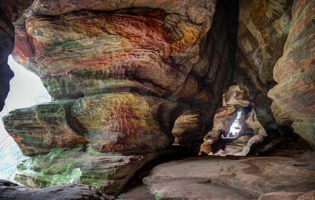
Photo: See1,Do1,Teach1 (Flickr), via Wikimedia Commons, CC BY 2.0 · Wikimedia Commons
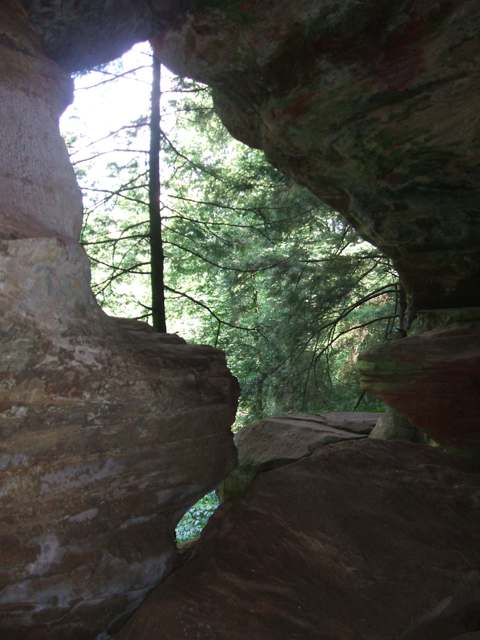
Photo: Photo by Yprahs, Wikimedia Commons, CC BY-SA 3.0 · Wikimedia Commons
Local history sources: en.wikipedia.org · en.wikipedia.org · en.wikipedia.org · en.wikipedia.org · hockinghills.com · commons.wikimedia.org · commons.wikimedia.org · commons.wikimedia.org · archive.org · hockinghills.com
Water
Mostly private wells The water here
- Logan, City Of45% of residentsGroundwater wells (8 wells)
- Old Straitsville-rockbridge27% of residentsGroundwater wells (8 wells)
- Laurelville, Vlg Of15% of residentsGroundwater wells (2 wells)
- Ross County Water Co. Inc13% of residentsTeays Valley Aquifer (buried valley groundwater)
Hospitals, fire stations and more
Inside Laurel Township, Hocking County's boundary: 1 museum and 1 public charging site. Press a pin or a name for its whole record and its source.
Museums, historical societies, gardens and zoos (1)
-
Crane Hollow PreserveArboretum or botanical garden · Rockbridge
- What it is
- Arboretum or botanical garden
- City
- Rockbridge
- Coordinates
- 39.49590, -82.58747
Search Wikipedia ↗ IMLS Museum Data Files (source) ↗ Street map and directions ↗
The museum list is IMLS's 2018 file; a museum may have closed or moved since.
Source: IMLS Museum Data Files, 2018.
Public EV charging (1)
-
Glenlaurel Inn, a Select Registry Property - Tesla Destination2 Level 2 · Rockbridge
- Address
- 14940 Mt Olive Rd, Rockbridge, OH 43149
- Ports
- 2 Level 2
- Plugs
- J1772, Tesla (NACS)
- Network
- Tesla Destination
- Phone
- 877-798-3752
Station Locator (NREL) ↗ Alternative Fuels Data Center (source) ↗ Street map and directions ↗
Source: NREL Alternative Fuels Data Center station list (May 2026), public and open stations, the posts at one address counted as one site.
Its ZIP codes
Each ZIP code that touches Laurel Township, Hocking County, with the share of its residents who live here and the same headline figures as the ZIP page.
| ZIP | Share | Water | Radon | Home value | Schools | Flood |
|---|---|---|---|---|---|---|
| 43149 Good Hope Township and Rockbridge | 36% | Mostly private wells | 15.7 pCi/L average radon | Median year built 1987 | Logan-Hocking Local · 3.5 stars overall | 4.8% of residents in the 1% floodplain |
| 43135 Perry Township and Laurelville | 2% | Mostly private wells | 4.7 pCi/L average radon | Median year built 1989 | Logan Elm Local · 3.5 stars overall | 6.3% of residents in the 1% floodplain |
| 43138 Logan | 1% | Mostly private wells | 3.7 pCi/L average radon | Median year built 1983 | Logan-Hocking Local · 3.5 stars overall | 8.8% of residents in the 1% floodplain |
Local government
Who holds office in Laurel Township, Hocking County, how its elections and ballot issues came out, and the state auditor's record.
Money issues on the ballot since 2016: 4 of 4 passed.
Ballot issues
| Date | Issue | For | Against | Result |
|---|---|---|---|---|
| 2024-03-19 | Issue: Laurel Township Fire Levy (Renewal) | 158 | 95 | Passed (62.45% for) |
| 2022-05-03 | Issue: Laurel Township Road Levy | 152 | 62 | Passed (71.03% for) |
| 2018-11-06 | Issue: Laurel Township 0.3 mill Renewal (0.3 mills, renewal) | 367 | 125 | Passed (74.59% for) |
| 2016-11-08 | Issue: Laurel Township 0.5 mill (Renewal) (0.5 mills, renewal) | 402 | 211 | Passed (65.58% for) |
Elections for office
| Date | Office | Candidates and votes |
|---|---|---|
| 2021-11-02 | Trustee (unofficial count) | Steven C. Hampshire 142, 46.56%; Jeff Hatfield 163, 53.44% |
| 2019-11-05 | Trustee | Luke Horn 137, 43.63%; John T Williams 177, 56.37% |
| 2019-11-05 | Fiscal Officer | Debbie Angle 256, 100.0% |
| 2015-11-03 | Township Trustee | John T. Williams 341, 100.0% |
| 2015-11-03 | Township Fiscal Officer | Debbie Angle 355, 100.0% |
Winners in bold. Results from the county board of elections' official canvass unless marked.
Auditor of State record
- No fiscal caution, watch or emergency on the Auditor of State's lists.
- Agreed Upon Procedures, 2023 to 2024, released 2025-11-06
The county
Hocking County: 8 ZIP codes, 13 cities, villages and townships, 27,033 people.
Nearby places
Quick answers
What county is Laurel Township, Ohio in?
Laurel Township, Hocking County is a township in Hocking County, Ohio, with 1,042 residents.
When was Laurel Township, Ohio founded?
Laurel Township, Hocking County was settled 1812; incorporated 1824-03-02. Founders on record: Smith and the Koons brothers (first settlers); organized by the Hocking County commissioners. Source
How did Laurel Township, Ohio get its name?
Laurel Township was named for the mountain laurel native to the area; it is the only Laurel Township in Ohio. Source
What ZIP code is Laurel Township, Ohio?
Laurel Township, Hocking County is served by ZIP codes 43149 and 43135; 43149 holds the largest share of its residents.
Where does Laurel Township, Ohio get its water?
The main water source for Laurel Township, Hocking County (Logan, City Of): Mostly private wells.
Cite this page
Cite this page as:
Cracked Buckeye, "Laurel Township, Hocking County", https://crackedbuckeye.com/place/laurel-township-hocking-county/, built 2026-10-31, accessed [date].
How to cite · Report a correction · Built 2026-10-31
