Water system
Laurelville, Vlg Of
EPA ID OH3700512 · Hocking County · 586 people served · owned by a local government
Laurelville, Vlg Of treats its own water from Groundwater wells (2 wells).
The system's record
- Active wells
- 2
- Serves
- 586 people · Hocking County
- EPA ID
- OH3700512
About this area's water
Did you know
- Laurelville is named for the mountain laurel that grows in the surrounding Hocking County hills.
- The village was deliberately founded in 1871 as a planned commerce and transportation center along the M&C Railroad, not an organic settlement.
- Three prehistoric Adena burial mounds sit near Laurelville (Karshner, George Deffenbaugh, and Edith Ross); the Karshner Mound is on the National Register of Historic Places.
- Laurelville was historically known as a fair town, hosting regional fairs that drew visitors from western Hocking County.
Source: en.wikipedia.org
History3
- 1871Laurelville was founded by William A. Albin and Jacob Riegel as a planned center for commerce and transportation.
- 1871 onwardArrival of the M&C Railroad made Laurelville a stop for travelers and merchants, spurring sawmills and dry-goods businesses.
- early 2020sThe local elementary school was demolished following school district consolidation.
Source: en.wikipedia.org
Treatment & pressure
How it is treated
Confirmed via EPA's federal Safe Drinking Water Information System (SDWIS): the village's only listed treatment process is post-hypochlorination (chlorine disinfection) of water drawn from its 2 groundwater wells. No filtration, aeration, or other treatment step is on file, and no published…
Source: data.epa.gov
Water pressure
Not published; no source-water assessment, engineering report, or council document describing system pressure could be located.
What it costs
No public rate schedule, ordinance, or utility billing page could be located online for this village of ~586 residents; the village does not appear to have a Municode/American…
Water quality & impurities
EPA compliance record
Lead at the tap: 90th-percentile result 1.6 ppb in 2025 (action level 15 ppb).
EPA health-based violations since 2015:
- 2024Lead and Copper Rule (lead) · treatment technique violation · returned to compliance
7 violations of any kind logged since 2020, 6 of them paperwork (monitoring, reporting, public notice or consumer report).
Supply stress
No source-water assessment, USGS aquifer stress data, or capacity study specific to this 2-well system was retrievable; unable to characterize stress with confidence for this small groundwater system serving under 600 people.
Sewers
Sanitary
Not confirmed whether Laurelville operates a municipal wastewater plant or relies on individual septic systems; no OEPA NPDES permit or council document describing sanitary sewer service was found.
Storm
Not published.
Sourcesverified
Compiled from the utility's own reports and public records, then independently re-checked against primary sources.
Main supplier in 1 ZIP code
Serves
Main water supplier in 2 ZIP codes
- 43101 · Adelphi100% of residents
- 43135 · Perry Township and Laurelville15% of residents
Population-weighted resident shares; a ZIP code can have more than one system on record. Recomputed from each ZIP's own system list, not from the map's cached footprint.
Buys from · Sells to
Laurelville, Vlg Of does not buy water from another system on record; it treats its own source water.
No other system is on record buying water from Laurelville, Vlg Of.
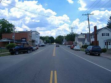
Photograph
On the map
Show this system's territory on the map — 2 ZIP codes in all.
Sources
U.S. EPA SDWIS and Community Water System Service Area Boundaries (v3, 2026), Ohio EPA primacy data, 2020 census blocks: the system serving most residents, traced through purchases to the treating utility; Ohio EPA 2023 Sewer and Water Rate Survey (Ohio State, May 2025) for household bills; Ohio EPA DEFA loan awards since 2016 for the loans paragraph · EPA SDWIS · EPA service area boundaries · Ohio EPA drinking water · Ohio EPA rate survey
Notable facts: en.wikipedia.org
History: en.wikipedia.org
Treatment: data.epa.gov