Local events in Falls Township, Hocking County
Nothing is posted for Falls Township itself yet; here is what is on within 20 miles. All local events in Falls Township, Hocking County
Know a calendar we should watch? Send the link
Checked October 20; the events page is refreshed daily.
How Falls Township, Hocking County began
Falls Township is the pioneer township of Hocking County, with settlement dating to 1798, decades before the county itself was organized in 1818 out of parts of Athens, Fairfield, and Ross counties. It takes its name not from the Hocking Hills show caves but from an actual waterfall on the Hocking River where a mill was built in 1814, before the township's formal creation. The Hocking Valley Railway reached the town of Logan, the county seat that sits in the township's southwestern portion, in 1869, tying the township into the region's 19th-century coal trade. Today Falls Township is a large, two-part township (about 50 square miles, split with a detached northeastern section locally called "The Gore") that surrounds Logan and functions as the county's population and government center. It is not the location of Old Man's Cave, Ash Cave, Cedar Falls, or Rock House, all of which lie in neighboring Benton and Laurel townships.
Settled 1798, per the pioneer-history chapter of an 1883 county history that calls Falls Township "The Pioneer Township", incorporated Organized as a township after 1814 (a mill at the falls on the Hocking River predates the township); Hocking County itself was organized March 1, 1818, by Not established from sources reviewed; the 1883 county history's Falls Township chapter (pp. 884-893) likely names first settlers, but we have not been able to read its full text.
Where the name comes from
The township takes its name from a waterfall on the Hocking River, where a mill had already been built in 1814, prior to the township's formation. This is a distinct, local falls/mill site (the Wikimedia Commons "Falls Mill Bridge" near Logan marks roughly this area today) and should not be confused with the much better-known waterfalls of the Hocking Hills (Old Man's Cave, Cedar Falls, Ash Cave), which are in Benton and Laurel townships, not Falls Township.
Before the town
No source reviewed documents a named Native American village, mound, earthwork, or trail specifically sited within Falls Township's boundaries. The county-level record is broader: the Hocking River's name is usually explained as a Delaware (Lenape) word rendered "Hockhocking," said to mean roughly "bottle river" from a bottle-shaped narrows in the stream, and the wider region was Adena-culture territory in the prehistoric period, with Delaware, Wyandot, and Shawnee people using the area by the 18th century. The documented prehistoric rock-shelter use in the Hocking Hills region -- notably the ash deposits at Ash Cave, read by researchers as centuries of accumulated campfire residue -- is specific to Ash Cave, which sources place in Benton Township, not Falls Township; it should not be attributed to this township. Hocking County's other well-documented mound sites (the George Deffenbaugh, Karshner, and Edith Ross mounds, and the Davis Works) are located in Salt Creek Township, also not Falls Township. We could not confirm any site-specific Native American history within Falls Township itself.
Nations recorded here: Wyandot, Shawnee, Lenape (Delaware), Adena culture.
Timeline
- — Settlement in what became Falls Township begins, making it the pioneer (earliest-settled) township of the future Hocking County.
- — A mill is built at the falls on the Hocking River that later gives Falls Township its name, before the township itself was organized.
- — Hocking County, containing Falls Township, is organized from parts of Athens, Fairfield, and Ross counties.
- — The Columbus and Hocking Valley Railroad's mainline reaches Logan, the county seat within Falls Township's southwestern portion, on August 28, 1869, linking the township to Columbus and the coal trade.
- — A branch line from Logan runs east to the New Straitsville coalfield, extending the railway network that passed through Falls Township.
- — The Hocking Valley Railway Historic District, which runs through Falls Township as well as Green Township, Logan, and Starr Township, is listed on the National Register of Historic Places on May 5.
- — A brick section of Enterprise-Iles Road in Falls Township, part of the historic Inter County Highway 360, is listed on the National Register of Historic Places (listed December 20, 2002).
- — The U.S. Census records 11,886 residents in Falls Township.
Stories
The falls that named the township, not the ones tourists come for
Ask most visitors what "the falls" are in Hocking County and they will point you toward Old Man's Cave or Cedar Falls, deep in the Hocking Hills. But Falls Township's own namesake falls is a different, smaller feature on the main stem of the Hocking River, near where Logan now stands, and it was already doing industrial work -- turning a mill -- by 1814, several years before the township that would carry its name was organized. Settlement in the area had begun even earlier, in 1798, making this the first-settled township in what became Hocking County in 1818. The Hocking Hills show caves that draw the crowds today (Old Man's Cave, Ash Cave, Cedar Falls, Rock House) sit in Benton and Laurel townships to the south and west; Falls Township's claim to the name rests on this older, humbler mill site, not on the sandstone gorges the county is now famous for.
A brick road built for the coal trade
In the early 20th century, Ohio experimented with brick paving on its intercounty highway system, and a stretch of Enterprise-Iles Road west of Logan, part of the old Inter County Highway 360, survives from that era within Falls Township. It was listed on the National Register of Historic Places in 2002 as a rare intact example of the brick roadway type. The road runs through the same corridor that the Hocking Valley Railway had already opened up decades earlier: the railroad reached Logan in 1869 specifically to move coal out of the Hocking Valley coalfield, and its historic district today threads through Falls Township along with Green Township, Logan, and Starr Township. Between the rail line and the brick road, the built landscape of the township still carries the marks of the coal-hauling economy that shaped it in the late 1800s and early 1900s.
Photographs
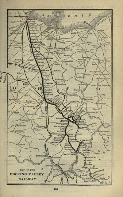
Photo: Poor's Manual of the Railroads of the United States, 1901, public domain · Wikimedia Commons
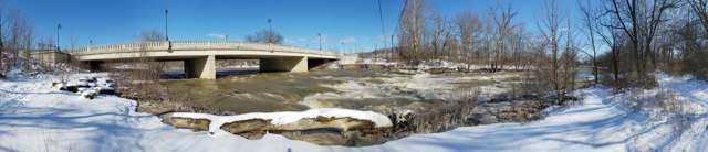
Photo: Dan Keck, CC0 · Wikimedia Commons
Local history sources: en.wikipedia.org · en.wikipedia.org · en.wikipedia.org · en.wikipedia.org · en.wikipedia.org · en.wikipedia.org · en.wikipedia.org · en.wikipedia.org · en.wikipedia.org · en.wikipedia.org · en.wikipedia.org · en.wikipedia.org · archive.org · commons.wikimedia.org · commons.wikimedia.org
Water
Mostly private wells The water here
- Logan, City Of96% of residentsGroundwater wells (8 wells)
- New Straitsville, Village Of3% of residentsHocking River Buried Valley Aquifer (wells)
- Old Straitsville Water Association0% of residentsHocking River Buried Valley Aquifer (wells)
- Old Straitsville-rockbridge0% of residentsGroundwater wells (8 wells)
Hospitals, fire stations and more
Inside Falls Township, Hocking County's boundary: 1 high-hazard dam, 1 public school, 1 museum, 3 shale and injection wells, 1 Toxics Release Inventory facility and 4 spill cases. Press a pin or a name for its whole record and its source.
High-hazard dams (1)
-
Lake Logan Dam PoorClear Fork · condition: poor
- Hazard class
- High: a failure would probably cost a life
- Condition
- Poor (assessed 05/23/2022)
- River or stream
- Clear Fork
- Purpose
- Recreation
- Type
- Earth
- Height
- 43 ft
- Storage
- 9,465 acre-feet
- Completed
- 1954
- Owner type
- State
- County
- Hocking County
- Nearest town (NID)
- West Logan
- Last inspection
- 05/23/2022
- Emergency action plan
- Yes
- NID ID
- OH00260
National Inventory of Dams record ↗ National Inventory of Dams (source) ↗ Street map and directions ↗
Source: U.S. Army Corps of Engineers National Inventory of Dams, August 2026. "High hazard" rates what a failure would cost downstream, not how likely one is; the condition is the state's assessment.
Public schools (1)
-
Chieftain Elementary School5 of 5 stars · Logan
- Address
- 28296 Chieftain Dr, Logan, OH 43138
- School district
- Logan-Hocking Local School District
- Kind (NCES)
- Regular School
- Students, 2023-24
- 363
- Teachers (full-time equivalent)
- 22
- Report card, 2025-26
- 5 of 5 stars
- Performance index
- 93.7%
- Ohio building IRN
- 000384
- NCES school ID
- 390442405282
NCES school record ↗ Ohio School Report Card ↗ Street map and directions ↗
Source: NCES EDGE public school locations 2024-25 and Common Core of Data 2023-24 (type, students, teachers); Ohio School Report Cards 2025-26 (Department of Education and Workforce), matched by name within the district.
Museums, historical societies, gardens and zoos (1)
-
Hocking Canal CompanyHistorical society · Logan
- What it is
- Historical society
- City
- Logan
- Coordinates
- 39.56258, -82.48591
Search Wikipedia ↗ IMLS Museum Data Files (source) ↗ Street map and directions ↗
The museum list is IMLS's 2018 file; a museum may have closed or moved since.
Source: IMLS Museum Data Files, 2018.
Shale and injection wells (3)
-
Cosper Well Service Inc. {Swiw#4} 1 InjectionInjection well (Class II)
- What it is
- Injection well (Class II)
- Operator
- Kilbarger Investments Inc
- County
- Hocking County
- API well number
- 34073215430000
- Coordinates
- 39.50797, -82.43746
ODNR oil and gas wells (source) ↗ Street map and directions ↗
-
Logan Sand & Gravel Co (Erp#14) 1 InjectionInjection well (Class II)
- What it is
- Injection well (Class II)
- Operator
- Hocking Hills Energy and Well Service Llc
- County
- Hocking County
- API well number
- 34073222110000
- Coordinates
- 39.48886, -82.39642
ODNR oil and gas wells (source) ↗ Street map and directions ↗
-
Robertson {Swiw#1} 14 InjectionInjection well (Class II)
- What it is
- Injection well (Class II)
- Operator
- Gaia Exploration Llc
- County
- Hocking County
- API well number
- 34073221610000
- Coordinates
- 39.55644, -82.45342
ODNR oil and gas wells (source) ↗ Street map and directions ↗
Source: ODNR Division of Oil and Gas Resources well inventory (September 2026): drilled Utica, Marcellus and horizontal wells and Class II injection wells not plugged. Older vertical wells are on the full map.
Facilities reporting toxic releases (1)
-
Ge Logan Glass PlantToxics Release Inventory · Logan
- Address
- 12680 State Route 93 North, Logan, OH 43138
- County
- Hocking County
- Status
- Reports to the Toxics Release Inventory (active)
- EPA program ID
- 43138GNRLLROUTE
- EPA registry ID
- 110056971807
EPA facility record ↗ EPA Facility Registry Service (source) ↗ Street map and directions ↗
Source: EPA Facility Registry Service, Toxics Release Inventory reporters. Reporting a release is required of large users of listed chemicals; it is not by itself a violation.
Spills reported since 2021 (4)
-
Sewage Human2025-07-29 · Falls Twp
- Reported
- 2025-07-29
- What spilled
- Sewage Human
- Where
- Falls Twp, Hocking County
- Ohio EPA district office
- SEDO
- Ohio EPA case number
- 2507EPA0001267
Ohio EPA spill reports (source) ↗ Street map and directions ↗
-
Oil Crude Reached water2022-04-07 · Falls Twp
- Reported
- 2022-04-07
- What spilled
- Oil Crude
- Largest amount reported
- 210 gallons
- Reached a waterway
- 37 - Monday Creek
- Where
- Falls Twp, Hocking County
- Ohio EPA district office
- SEDO
- Ohio EPA case number
- 2204EPA0000482
Ohio EPA spill reports (source) ↗ Street map and directions ↗
-
Oil Petroleum Not Otherwise Specified (Nos)2022-01-11 · Falls Gore Twp
- Reported
- 2022-01-11
- What spilled
- Oil Petroleum Not Otherwise Specified (Nos)
- Largest amount reported
- 50 gallons
- Where
- Falls Gore Twp, Hocking County
- Ohio EPA district office
- SEDO
- Ohio EPA case number
- 2201EPA0000031
Ohio EPA spill reports (source) ↗ Street map and directions ↗
-
Sheen Rainbow / Hydrocarbon2026-06-12 · Falls Twp
- Reported
- 2026-06-12
- What spilled
- Sheen Rainbow / Hydrocarbon
- Where
- Falls Twp, Hocking County
- Ohio EPA district office
- SEDO
- Ohio EPA case number
- 2606EPA0001051
Ohio EPA spill reports (source) ↗ Street map and directions ↗
Source: Ohio EPA emergency response spill reports, 2021 to September 2026, one point per case where Ohio EPA placed it. A report is what the caller or responder recorded; amounts are often blank or estimated.
Its ZIP codes
Each ZIP code that touches Falls Township, Hocking County, with the share of its residents who live here and the same headline figures as the ZIP page.
| ZIP | Share | Water | Radon | Home value | Schools | Flood |
|---|---|---|---|---|---|---|
| 43138 Logan | 27% | Mostly private wells | 3.7 pCi/L average radon | Median year built 1983 | Logan-Hocking Local · 3.5 stars overall | 8.8% of residents in the 1% floodplain |
| 43766 New Straitsville | 10% | Mostly private wells | Too few radon tests | Median year built 1968 | Southern Local · 3.5 stars overall | 2.9% of residents in the 1% floodplain |
| 43149 Good Hope Township and Rockbridge | 1% | Mostly private wells | 15.7 pCi/L average radon | Median year built 1987 | Logan-Hocking Local · 3.5 stars overall | 4.8% of residents in the 1% floodplain |
Local government
Who holds office in Falls Township, Hocking County, how its elections and ballot issues came out, and the state auditor's record.
Money issues on the ballot since 2016: 2 of 2 passed.
Ballot issues
| Date | Issue | For | Against | Result |
|---|---|---|---|---|
| 2021-11-02 | Issue: Falls Township Fire Protection | 662 | 308 | Passed (68.25% for), unofficial |
| 2016-11-08 | Issue: Falls Township 1 mill (Renewal) (1.0 mills, renewal) | 1,566 | 693 | Passed (69.32% for) |
Elections for office
| Date | Office | Candidates and votes |
|---|---|---|
| 2021-11-02 | Trustee (unofficial count) | Sam Eggleston 1,240, 44.44%; Scott R. Harden 1,049, 37.6%; Jason Kallimanis 501, 17.96% |
| 2019-11-05 | Trustee | Chuck Hopkins 1,421, 100.0% |
| 2019-11-05 | Fiscal Officer | Kim Edgar 1,339, 100.0% |
| 2015-11-03 | Township Trustee | Charles P. Hopkins 1,852, 60.38%; Hubie Taulbee 1,215, 39.62% |
| 2015-11-03 | Township Fiscal Officer | Kim Edgar 2,559, 100.0% |
Winners in bold. Results from the county board of elections' official canvass unless marked.
Auditor of State record
- No fiscal caution, watch or emergency on the Auditor of State's lists.
- Agreed Upon Procedures, 2024 to 2025, released 2026-07-28
- Agreed Upon Procedures, 2022 to 2023, released 2024-12-26
The county
Hocking County: 8 ZIP codes, 13 cities, villages and townships, 27,033 people.
Nearby places
Quick answers
What county is Falls Township, Ohio in?
Falls Township, Hocking County is a township in Hocking County, Ohio, with 5,120 residents.
When was Falls Township, Ohio founded?
Falls Township, Hocking County was settled 1798, per the pioneer-history chapter of an 1883 county history that calls Falls Township "The Pioneer Township"; incorporated Organized as a township after 1814 (a mill at the falls on the Hocking River predates the township); Hocking County itself was organized March 1, 1818. Founders on record: Not established from sources reviewed; the 1883 county history's Falls Township chapter (pp. 884-893) likely names first settlers, but we have not been able to read its full text. Source
How did Falls Township, Ohio get its name?
The township takes its name from a waterfall on the Hocking River, where a mill had already been built in 1814, prior to the township's formation. Source
What ZIP code is Falls Township, Ohio?
Falls Township, Hocking County is served by ZIP codes 43138 and 43766; 43138 holds the largest share of its residents.
Where does Falls Township, Ohio get its water?
The main water source for Falls Township, Hocking County (Logan, City Of): Mostly private wells.
Cite this page
Cite this page as:
Cracked Buckeye, "Falls Township, Hocking County", https://crackedbuckeye.com/place/falls-township-hocking-county/, built 2026-10-31, accessed [date].
How to cite · Report a correction · Built 2026-10-31