Local events in Laurelville
Nothing is posted for Laurelville itself yet; here is what is on within 20 miles. All local events in Laurelville
Know a calendar we should watch? Send the link
Checked October 20; the events page is refreshed daily.
How Laurelville began
Laurelville was laid out in 1871 by William A. Albin and Jacob Riegel in Perry Township, on Salt Creek in the northwestern corner of Hocking County, as a planned stop on the Marietta and Cincinnati Railroad. It took its name from the mountain laurel that grew thick on the surrounding hills. The railroad turned it into a trading center for western Hocking County, drawing sawmills and dry-goods stores, and it later hosted county fairs. The village sits close to where Hocking, Pickaway, and Fairfield counties meet, and some of its surrounding farm and township history is shared with those neighbors; the village itself has stood in Hocking County's Perry Township since its founding.
Platted 1871-12-23, by John Albin, W. S. Albin and Solomon Riegel (1883 county history); Wikipedia names William A. Albin and Jacob Riegel.
Where the name comes from
The 1883 county history says Laurelville took its name from Laurel Creek, which empties into Salt Creek at the village; Wikipedia says it was named for the mountain laurel that grew on the surrounding hills. The creek and the township to the east are themselves named for the laurel bush.
Before the town
No village-specific accounts of Native villages, trails, or treaty events at Laurelville itself were found. But the immediate vicinity holds two documented Adena burial mounds: the Karshner Mound, on the second terrace above Salt Creek, and the George Deffenbaugh Mound, on a ridge northeast of the village. Both were built by people of the Adena culture (roughly 1000 BC to AD 400), based on their conical shape and terrace/ridge placement, and both were listed on the National Register of Historic Places on July 15, 1974. Neither has been professionally excavated (the Deffenbaugh mound was informally dug into before 1941). Hocking County as a whole was hunted and lived in by the Shawnee, Lenape (Delaware), and Wyandot in the 1600s and 1700s, and the Hocking River's name itself comes from the Delaware (Lenape) word for 'bottle,' after the bottle-shaped falls on the river six or seven miles northwest of Lancaster.
Nations recorded here: Adena culture, Shawnee, Lenape (Delaware), Wyandot.
- Karshner Mound (mound) — second terrace above Salt Creek, near Laurelville, Hocking County, Adena culture, c. 1000 BC - AD 400 (en.wikipedia.org)
- George Deffenbaugh Mound (mound) — ridgeline northeast of Laurelville, Hocking County, Adena culture, c. 1000 BC - AD 400 (en.wikipedia.org)
Timeline
- — William A. Albin and Jacob Riegel laid out Laurelville in Perry Township as a planned commercial and rail stop.
- — The Marietta and Cincinnati Railroad's arrival made Laurelville a stop for travelers and merchants, spurring sawmills and dry-goods businesses.
- — John Albin, W. S. Albin and Solomon Riegel, helped by Rufus Dodson, lay out Laurelville on section 29 at the mouth of Laurel Creek in Perry Township; there are only three houses at first, and Allen Strous adds to it in 1876 and 1882.
- — Solomon Riegel builds the first house and the first hotel, the Laurelville House; Jacob Friend later builds and keeps Friend's Hotel.
- — A post office is established with John Bates as first postmaster, succeeded April 1 by Rufus Dodson.
- — Laurelville has about 200 people, three general stores, a planing mill, a sawing mill, a flour mill of fifty barrels a day, three blacksmith shops and a harness shop, and has been one of the best lumber markets in the county.
- — The village has two churches, a Cumberland Presbyterian and a Baptist, and a school; South Perry, laid out in 1838, and Buena Vista, laid out in 1848, are the township's other villages.
- — The Karshner Mound and the George Deffenbaugh Mound, both near Laurelville, were listed on the National Register of Historic Places on the same day.
- — Laurelville's elementary school was demolished following local school district consolidation.
- — Perry Township, which holds Laurelville, has 2,408 people in the census.
Stories
A mound nobody has ever dug
On a farm terrace above Salt Creek near Laurelville sits the Karshner Mound: 100 feet across and 28 feet high, one of the largest burial mounds left standing in Ohio. Farmers around it have plowed their fields for two centuries but left the mound itself untouched, and the trees and grass that cover it have kept it from washing away. No archaeologist has ever opened it. Its builders are inferred, not proven: its cone shape and its position on a terrace above a small stream match the pattern the Adena culture used elsewhere in the Hocking Valley between roughly 1000 BC and AD 400. A half mile or so northeast, a smaller mound named for George Deffenbaugh was less lucky — someone dug into its crest and sides sometime before 1941, and a stone mound nearby suggests people from the later Fort Ancient culture were still using the same ridge more than a thousand years after the first mound went up.
A railroad village on the edge of three counties
When Albin and Riegel platted Laurelville in 1871, they were betting on a rail line, and the bet paid off. The Marietta and Cincinnati Railroad's stop turned a crossroads into a trading town for western Hocking County: sawmills cut the surrounding hardwood, dry-goods stores served farm families, and the village became social center enough to host its own fairs. Laurelville sits close enough to the Hocking-Pickaway-Fairfield county corner that its farm neighborhood and school district have always drawn from more than one county, even though the platted village itself has stayed inside Hocking County's Perry Township.
Photographs
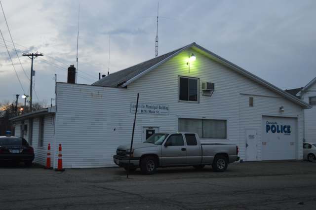
Photo: Nyttend, public domain · Wikimedia Commons
Local history sources: en.wikipedia.org · en.wikipedia.org · en.wikipedia.org · hocking.ohgenweb.org · commons.wikimedia.org · archive.org · en.wikipedia.org
Water
Mostly private wells The water here
- Laurelville, Vlg Of55% of residentsGroundwater wells (2 wells)
- Ross County Water Co. Inc45% of residentsTeays Valley Aquifer (buried valley groundwater)
Hospitals, fire stations and more
Inside Laurelville's boundary: 1 fire or EMS station and 1 library. Press a pin or a name for its whole record and its source.
Fire and EMS stations (1)
-
Laurelville Volunteer Fire DepartmentLaurelville
- Address
- 18751 Main Street, Laurelville, OH 43135
- Coordinates
- 39.47142, -82.73989
USGS National Map structures (source) ↗ Street map and directions ↗
Source: USGS National Map structures (most Ohio records last updated 2019 to 2022), checked against the Columbus and Cleveland station lists. The department that answers a call is set by jurisdiction and mutual aid, not by distance.
Public libraries (1)
-
Laurelville BranchBranch · Laurelville
- Address
- 16240 Maple Street, Laurelville, OH 43135
- What it is
- Branch
- Library system
- Logan-Hocking County District Library
- Open
- 2,228 hours a year, 52 weeks
- Building
- 4,400 sq ft
- System's visits, FY2024
- 63,752
- System's loans, FY2024
- 188,662
- People the system serves
- 26,795
- Phone
- (740) 332-4700
IMLS Public Libraries Survey (source) ↗ Street map and directions ↗
Source: IMLS Public Libraries Survey FY2024 (outlets and their systems). Any Ohio resident can get a free card at any Ohio public library.
Its ZIP codes
Each ZIP code that touches Laurelville, with the share of its residents who live here and the same headline figures as the ZIP page.
| ZIP | Share | Water | Radon | Home value | Schools | Flood |
|---|---|---|---|---|---|---|
| 43135 Perry Township and Laurelville | 12% | Mostly private wells | 4.7 pCi/L average radon | Median year built 1989 | Logan Elm Local · 3.5 stars overall | 6.3% of residents in the 1% floodplain |
Local government
Who holds office in Laurelville, how its elections and ballot issues came out, and the state auditor's record.
Money issues on the ballot since 2019: 2 of 2 passed.
Ballot issues
| Date | Issue | For | Against | Result |
|---|---|---|---|---|
| 2022-05-03 | Issue: Laurelville Village Current Expenses | 35 | 20 | Passed (63.64% for) |
| 2021-11-02 | Issue: Laurelville Village Sensible Marihuana Ordinance | 36 | 49 | Failed (42.35% for), unofficial |
| 2019-11-05 | Issue: Village of Laurelville Tax Levy - Renewal | 52 | 23 | Passed (69.33% for) |
Elections for office
| Date | Office | Candidates and votes |
|---|---|---|
| 2021-11-02 | Member of Council (unofficial count) | Sue Ann Hinton 57, 37.25%; Donald R. Kempton, Jr. 56, 36.6%; Colleen K. Robinette Rife 40, 26.14% |
| 2019-11-05 | Member of Council | Branden Anderson 51, 45.95%; Cindy Anderson 60, 54.05% |
| 2019-11-05 | Mayor | Brent Ebert 66, 100.0% |
| 2019-11-05 | Fiscal Officer | Darcy A Tisdale 66, 100.0% |
| 2017-11-07 | Council (number of seats not on file, so winners are not marked) | Sue Ann Hinton 63, 27.39%; Donald R Kempton Jr. 57, 24.78%; Bobby Platz 61, 26.52%; Colleen Rife 49, 21.3% |
Winners in bold. Results from the county board of elections' official canvass unless marked.
Auditor of State record
- No fiscal caution, watch or emergency on the Auditor of State's lists.
- Agreed Upon Procedures, 2023 to 2024, released 2025-07-22
The county
Hocking County: 8 ZIP codes, 13 cities, villages and townships, 27,033 people.
Nearby places
Rain and snow
How much has actually fallen on Laurelville, day by day, from 1893 to now. Daily totals, not averages.
- rain, last 30 days
- 0.91 in
- 2026-09-30 to 2026-10-29
- rain so far in 2026
- 45.6 in
- 11.0 in above normal for the date
- snow so far in 2026
- 15.6 in
- a normal year brings 16.3 in
- a normal year
- 40.6 in
- average of 30 years, 1991-2020
| Month | Rain (in) | Snow (in) | Days counted |
|---|---|---|---|
| October 2026 | 0.91 | — | 29 |
| September 2026 | 7.97 | — | 30 |
| August 2026 | 8.55 | — | 31 |
| July 2026 | 6.05 | — | 31 |
| June 2026 | 3.30 | — | 30 |
| May 2026 | 5.27 | — | 31 |
| April 2026 | 3.47 | — | 30 |
| March 2026 | 7.27 | 1.2 | 31 |
| February 2026 | 1.12 | 4.2 | 28 |
| January 2026 | 1.65 | 10.2 | 31 |
| December 2025 | 2.14 | 9.9 | 31 |
| November 2025 | 2.83 | 1.7 | 30 |
| Wettest year | 2011 — 61.7 in |
|---|---|
| Driest year | 1987 — 22.3 in |
| Snowiest year | 1910 — 49.7 in |
| Wettest day on record | 10 July 2002 — 5.75 in |
| Heaviest snowfall in a day | 5 April 1987 — 12.01 in |
| Deepest snow on the ground | 5 April 1987 — 19.02 in |
55% of these days are measurements from a gauge inside Laurelville; the rest are estimated from the nearest gauges around it.
48,690 days of records, 1893-01-01 to 2026-10-29. Source: NOAA NCEI GHCN-Daily, 3,240 gauges in and around Ohio. A day is "gauged" when a gauge standing inside the boundary reported it, and the value is the mean of those gauges. Otherwise it is interpolated by inverse distance from every gauge reporting within 50 miles. Nothing is carried forward, back-filled or smoothed. Against NOAA nClimDiv county monthly precipitation over 136,848 complete county-months (checked 2026-10-31): correlation 0.9515, median absolute difference 0.217 in a month. Built 2026-10-31 from the Cracked Buckeye precipitation archive. Snow is the softer number — snowfall is measured by hand with a ruler, no agency publishes a gridded county snowfall series, and blowing snow defeats every observer.
Environmental permits and filings
What Ohio EPA has on file for Laurelville: permits, inspections, violations, cleanups and the state loans behind sewer and water work. Every line links to the agency's own document.
- facilities and sites on file
- 3
- those placed on the map inside Laurelville
| Program | Facilities and sites |
|---|---|
| State sewer loans | 2 |
| Public drinking water | 1 |
| Date | Facility or site | What |
|---|---|---|
| LAURELVILLE, VLG OF PWS | Public drinking water report | |
| LAURELVILLE, VLG OF PWS | Public drinking water notice of violation | |
| LAURELVILLE, VLG OF PWS | Public drinking water compliance letter | |
| LAURELVILLE, VLG OF PWS | Public drinking water plan | |
| LAURELVILLE, VLG OF PWS | Public drinking water inspection | |
| LAURELVILLE, VLG OF PWS | Public drinking water notice of violation | |
| LAURELVILLE, VLG OF PWS | Public drinking water compliance letter | |
| LAURELVILLE, VLG OF PWS | Public drinking water report | |
| LAURELVILLE, VLG OF PWS | Public drinking water warning letter | |
| LAURELVILLE, VLG OF PWS | Public drinking water warning letter | |
| LAURELVILLE, VLG OF PWS | Public drinking water notice of violation | |
| LAURELVILLE, VLG OF PWS | Public drinking water compliance letter | |
| LAURELVILLE, VLG OF PWS | Public drinking water notice of violation | |
| LAURELVILLE, VLG OF PWS | Public drinking water inspection | |
| LAURELVILLE, VLG OF PWS | Public drinking water compliance letter | |
| LAURELVILLE, VLG OF PWS | Public drinking water report | |
| LAURELVILLE, VLG OF PWS | Public drinking water inspection | |
| LAURELVILLE, VLG OF PWS | Public drinking water violation resolved | |
| LAURELVILLE, VLG OF PWS | Public drinking water notice of violation | |
| LAURELVILLE, VLG OF PWS | Public drinking water compliance letter | |
| LAURELVILLE, VLG OF PWS | Public drinking water permit | |
| LAURELVILLE, VLG OF PWS | Public drinking water violation resolved | |
| LAURELVILLE, VLG OF PWS | Public drinking water notice of violation | |
| LAURELVILLE, VLG OF PWS | Public drinking water report | |
| LAURELVILLE, VLG OF PWS | Public drinking water notice of violation |
Source: Ohio EPA eDocument portal (edocpub.epa.ohio.gov), indexed 2026-10-14. Facilities are placed on the map from Ohio EPA's own map layers, EPA's Facility Registry, coordinates written in the filings, or a geocoded street address. A permit filed under a private person's name (most are household septic systems) is counted but never named, placed or linked; licenses for individual workers and open-burning notices are left out entirely.
Quick answers
What county is Laurelville, Ohio in?
Laurelville is a village in Hocking County, Ohio, with 512 residents.
When was Laurelville, Ohio founded?
Laurelville was laid out 1871-12-23. Founders on record: John Albin, W. S. Albin and Solomon Riegel (1883 county history); Wikipedia names William A. Albin and Jacob Riegel. Source
How did Laurelville, Ohio get its name?
The 1883 county history says Laurelville took its name from Laurel Creek, which empties into Salt Creek at the village; Wikipedia says it was named for the mountain laurel that grew on the surrounding hills. Source
What ZIP code is Laurelville, Ohio?
Most of Laurelville is in ZIP code 43135.
Where does Laurelville, Ohio get its water?
The main water source for Laurelville (Laurelville, Vlg Of): Mostly private wells.
Cite this page
Cite this page as:
Cracked Buckeye, "Laurelville, Hocking County", https://crackedbuckeye.com/place/laurelville/, built 2026-10-31, accessed [date].
How to cite · Report a correction · Built 2026-10-31
